Embed Size (px)
Citation preview

Air Transportation Technical Advisory Committee
Michael Mallonee
June 13, 2014
2014-2016 Roster Update and Officer Positions

Roster
• Members of ATTAC are selected on an as-needed basis…
• …shall be approved by NCTCOG’s Executive Board
• Committee members shall be provided for by local governments…
Committee Guidelines
2

Roster
• Voting members shall be technical or staff level, not elected officials…
• Non-voting members may include representatives from industry groups, educational institutions, major regional aviation employers, State and federal aviation officials
Committee Guidelines
3

Roster
• A Chair, Vice Chair, and Secretary for ATTAC shall be designated by NCTCOG staff…
• Chair, Vice Chair, and Secretary are considered for re-election every two years
Committee Guidelines
4

Roster Revisions
• Some voting to non-voting based on representation guidelines
• Some removed due to participation/retirement
• Proposed additions
– Airports, Academic Institutions, Industry Groups
Reference HandoutUpdated Roster
5

Action RequestedApproval of Proposed Roster Revisions
• NCTCOG Executive Board will take action on June 26
• Letters and certifications will be sent after approval to notify members of changes
6

June 13, 2014

Decision
Transition
Tenants / Customers / Employees
McKinney Air Center 2013
McKinney Air Center Comments
McKinney Air Center 2014 / Awards
Aviation Community
Development Continues / Planning for the Future
Gateway to McKinney and Collin County
Agenda

• City Council / Airport Board / Airport Director
• Operations Started November 1, 2013
• Fuel Contracts / supply
• Line equipment / fuel trucks
• IT Department / communications/ software
• Transition went as planned / all customers were handled
with no delays
• Finance handling of leases / payments
• Education of fuel programs
Start Up Operations

10 line technicians 65 years of Aviation FBO experience.
Line Staff all NATA Safety 1st Certified.
5 Customer Representatives 52 years of Aviation FBO
experience.
Education of Staff on FBO expectations
• Dashboard Goals
• Clean Facilities / Image
• On time performance
• Exceeding customers expectations
• Accountability
Employee Staff

• Building trust with current tenants.
• Involvement with flight clubs/ EAA / MHOA /CHOA.
• Becoming involved with our customers. Who are our
customers, what are there needs.
• What services are we providing that are needed.
• FBO model has changed.
• Listen and responding to our employee suggestions.
• Building the synergy, doing what we say.
Tenants / Customers / Employees

McKinney Air Center (Nov 2013)

McKinney Air Center (Nov 2013)

AirNav Comments on 09-Jun-2014
Excellent stopover, service is perfect, these folks do everything they possibly can to make your stay pleasant. A pleasure to do business with these folks!
AirNav Comments on 09-Jun-2014
We were very pleased with the line and desk service for our C182. Rental car was brought to plane for loading. We were fueled up and tied down in less than 10 minutes. Similar experience on departure. Perfect location for visiting Richardson/Plano area. Would definitely use again.
AirNav Comments: on 20-Jan-2014
We stopped in on Sunday after doing practice instrument approaches and were treated very well. They were very courteous, provided a rental car at no cost when they were out of crew cars so we could get lunch and were very responsive to out needs. Erin at the front desk was very nice and responsive. Fuel was reasonably priced. This is a very positive change from how this were when we previously used this FBO. The city has taken over and we were very impressed with the positive changes. We did purchase 100 gallons of Jet A for our King Air and were glad to do some business with these new folks. We will make a point of stopping there more often in light of these positive changes. Best, Dave
McKinney Air Center Comments

McKinney Air Center (June 2014)

McKinney Air Center (June 2014)

Pilot Choice Awards
#1 US FBO 2014

Aviation Community

• November 2013 96 T-hangars at 75% occupancy
• June 2014 96 T-hangars at 98% occupancy
• Signing of Two Major Tenants / Monarch Air/ First
Flight
• Development of new hangars
• New Apron Construction FY 15
• New FBO terminal FY 16-17
• Land Acquisition / Future expansion
Development Continues

Planning for the Future

Corporate Clients / Economic Impact
New Families
New Jobs
Community Involvement
Tax Base
Gateway to McKinney and Collin
County

Air Transportation Technical Advisory Committee
Mike Branum
June 13, 2014
Small Unmanned Aircraft Systems (sUAS)for Planning and Public Safety

Outline
• General UAS Overview
• Context, Background
• UAS Policy, Regulations
• NCTCOG sUAS Projects
– Airport Pilot Project– Department of Justice Grant
2

High Altitude Long Endurance (HALE):
RQ-4 Global Hawk
Wingspan: 116-130 ft.
Length: 44-47 ft.
Ceiling: 60,000 ft.
Speed: 350+ mph
Medium Altitude Long Endurance (MALE):
MQ-1 Predator
Wingspan: 55 ft.
Length: 27 ft.
Ceiling: 25,000 ft.
Speed: Up to 135 mph
Low Altitude Long Endurance:
GNAT 750
Wingspan: 55 ft.
Length: 27 ft.
Ceiling: 25,000 ft.
Speed: Up to 135 mph
Small/Micro UAS:
WASP Block III
Wingspan: 28.5 inches
Length: 15 inches
Range: 3.1 Miles
Speed: Up to 40 mph
General UAS Overview
3

Benefits of UAS
• Low initial and operating costs
• Multiple law enforcement applications helping prevent loss of life
• Commercial growth
– Aerial photogrammetry and surveys
• Less noise than manned aircraft
• Fewer emissions than manned aircraft
4

Local news…
• Drone lost on top of AT&T Stadium
• Broke hobbyist rule and flew over Downtown Dallas
http://www.youtube.com/watch?v=2nu8R5mjFyI#action=share
5

UAS Policy, RegulationsFederal• FAA Modernization and Reform Act (H.R. 658)
– Mandates integration of UAS by September 2015– Selection of six UAS test ranges (including one in Texas)
• FAA Notice 8900.227– Provides policies for review, evaluation of safety, interoperability of UAS flight
operations in the NAS – Utilized when assessing applications for a Certificate of Waiver or Authorization (COA)
• AC 91-57: Guidance for Model Aircraft/Hobbyists– FAA guidance for model aircraft flights should be kept below 400 feet AGL– Should be flown a sufficient distance from populated areas and full-scale aircraft– Not for business purposes
State• Texas House Bill 912
– Outlines 19 lawful means of acquiring imagery with the use of UAS(includes research and law enforcement purposes)
6

System Plan UAS Report Recommendations
• Data collection– Track regional UAS operations
• Planning– Infrastructure, necessary security
enhancements, airspace
• Communication–Organize regional UAS group
– Facilitate public comments on regional UAS activity
7

Arlington Unmanned Systems Consortium (USC)
• Objectives – Education, workforce development, and training
– Research, development, and commercialization
– Industry sector development
– Policy and standards development
– Access to capital
• NCTCOG/ATTAC Participation– Support aviation education, UAS workforce growth
(Wagner Peyser Grant)
– Coordinate with industry partners, educators
– Liaison to ATTAC on any outcomes
August 2012:ATTAC Approved
Continued Participation in USC
8

Potential NCTCOG sUASProjects
9

Pilot Project: Aerial Imagery Collection at Arlington Airport
• Project Partners– TxDOT
– City of Arlington (Airport and Police Department)
– FAA
• Goals– Produce six-inch resolution color digital orthophotography
– Provide completed orthophotography to local governments
– Process, analyze, and summarize collected data
– Refine data collection and processing procedures (including possible enhancements for aviation planning) and monitor progress
10

Project Feasibility
• Arlington City Council approves Arlington Police Department (APD) operation of sUAS
• APD’s COA allows operation within city limits
• HB912 allows for image capture above public property by law enforcement
11

Anticipated Benefits
• Arlington Airport: Gains high resolution aerial imagery and airport GIS data
• APD: Demonstrates additional cost savings, capabilities of a municipal asset
• NCTCOG: Collection of imagery, GIS data complementary to aviation system planning goals
• Will demonstrate ability to capture data for a variety of other transportation projects
12

NCTCOG sUAS Projects
Proposed Project Area
13

Online UAS Flight Data Reporting System Grant
Agency: Department of Justice (National Institute of Justice)
Purpose: Develop, maintain, and host web-based reporting system to collect flight-operations data from law enforcement and other public safety agencies use of sUAS
Goal: More informed analysis, documentation, research of this technology’s use while:
– Complementing FAA UAS integration efforts– Providing access to comprehensive data and reporting of sUAS flight
activities
Objectives: Dynamic website with relevant content and data that promotes safe, effective, lawful use of sUAS
14

Online UAS Flight Data Reporting System Grant
If awarded, work would being next calendar year (2015).
ATTAC may be asked to serve in an advisory role.
Partners:• NCTCOG - LEAD
• UTA Research Institute – Publish research
• Arlington PD – Law Enforcement Advisement and UAS data
15

Discussion
Questions/Comments

Michael W. MalloneePrincipal Transportation Planner
North Central Texas Council of Governments
ATTACJune 13, 2014
FAA Imagery Collection for Aerodrome Mapping

Overview
• GIS and Airports GIS
• NCTCOG Aerial Imagery
• Extracting AGIS Features via AMDB
• Anticipated deliverables
• Questions?
2

Transportation and GIS
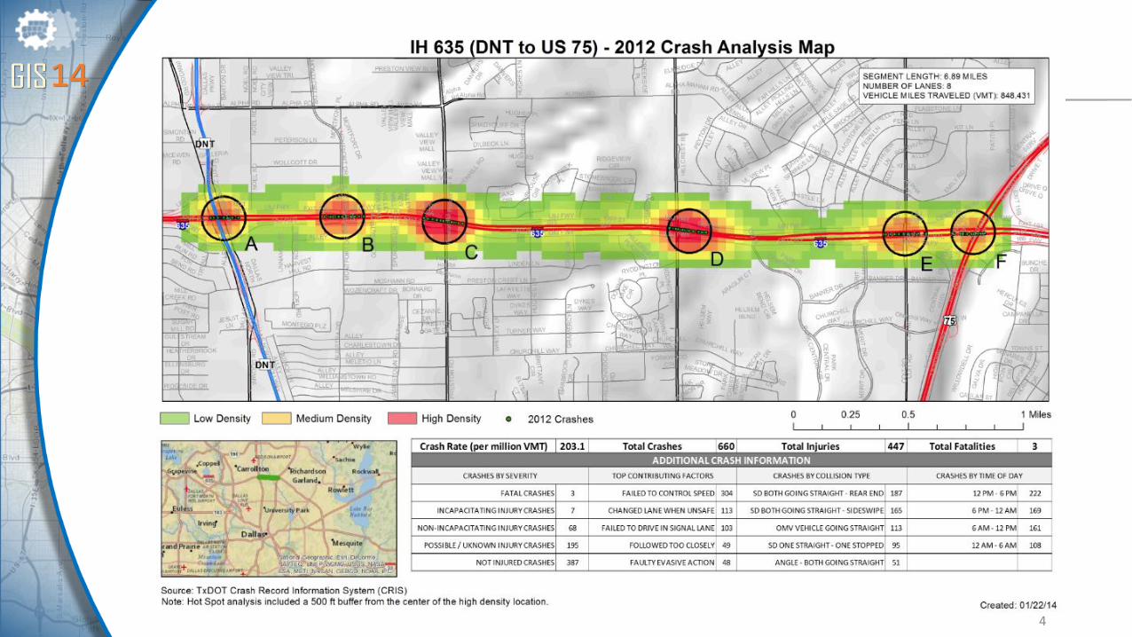
• Crash Density Analysis
• Congestion Management Processes
• Transit/Rail Alignments
• Environmental Justice and Title VI Analysis
• Demographic Traffic Survey Zones
3
4

5

• Helps collect airport and aeronautical data for NextGen
• Guided by AC’s, (150/5300 16-18B) the airport sponsor collects data and uses web application to access airport data and submit changes
• Products • Electronic Airport Obstruction Charts • Electronic Airport Layout Plans
• Integrate multiple versions of airport data • Preliminary• Current• Planned• Temporary
FAA Airports GIS
6

Research and Information Services
• Acts as Texas mandated GIS coordinator for our 16-county region
• Provides• High-quality aerial images (ODD YEARS)
• Digital elevation contours
• Planimetrics (heads-up digitizing)
• ESRI certified training
• Parcel-based land use
7

Regional Ortho Photography• High-quality, color, digital aerial
photography (orthos) for region
• Cost-sharing objective for local governments
• Flown in January, February, and March
• Average savings of 75% compared to purchasing aerial imagery separately
• Images in Tiff (.tif) and Mr. Sid (.sid) format in either six-inch or one-foot resolution
8

Connecting the Dots – AMDB to AGIS
• Aerodrome mapping database (AMDB) is a geographic information system (GIS) database to describe airports
• Commonly used by software companies for Flight Management Systems
• Designed to improve airport situational awareness and/or to supplement surface navigation(moving map in flight deck)
9

Aerodrome Mapping Database (AMD)

Aerodrome Mapping Database (AMD)

Aerodrome Mapping Database (AMD)

Aerodrome Mapping Database (AMD)

RTCA Certification
• Requirements and Technical Concepts for Aviation
• RTCA is a private, not-for-profit association founded in 1935
• Public-Private Partnership for developing consensus among diverse, competing interests on critical aviation modernization issues
• DO-200A Standards for Processing Aeronautical Data
• May help expedite NGS review and control of survey points
14

Phase One: 2D Base Map of NPIAS Airports
• Proof of concept to gain AC 150/5300-18B data from existing AMDB extraction techniques
• AMDB quality process is certified by DO-200A
• Use combination of existing NCTCOG orthoimagery and satellite imagery
• Existing geodetic controls
15

Anticipated Deliverables
• Non-Safety critical features
o Runway
o Airport Boundary
o Fencing
o Taxiway
o Airfield Lighting
o Airport Parcel
• Can we achieve AC 16A-17C-18B accuracy?
• All NPIAS Airports in NCT
• Use for airport development plans, eALP, etc.
16
(will need help from ATTAC to populate some attributes)

ArcGIS for Aviation: Airports
• Spatial analysis with regional Part 77
• Export shapefiles to FAA standards
• Use in ArcScene for 3D representation
• Collect regional wildlife migration patterns
17

Online Web Portal
• Share data with public and/or select airport users (ArcGIS Online)
• Create a regional data clearing house specific to aviation planning
• Implementation tracking
• Land use
• Capital improvements
• Wildlife
www. dfwmaps.com used only as example18

Michael Mallonee
Principal Transportation Planner (Lead)
817-704-2513
Michael Branum
Transportation Planner III
817-704-5642
NCTaviationplan.com
For more information:

Air Transportation Technical Advisory Committee
June 13, 2014
Touch and Goes

• Denton Enterprise Airport
• Fort Worth Meacham Airport
• Lancaster Regional Airport
• McKinney National Airport
• Mid-Way Regional Airport
• Mineral Wells Airport
Airport Updates
2
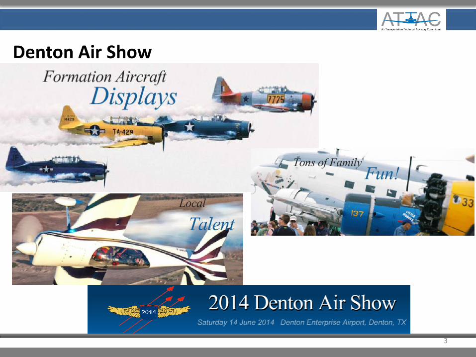
Denton Air Show
3

Fort Worth Meacham – Updates
• RWY 17/35 overlay, new LED runway lights and upgrading the ALCMS computer
• Hangar 12N near completion
• New modern 26,000 sq. ft. hangar facility for Executive Flight Services
• New RTR towers are operational and active; hangar 44N has been allowed to proceed vertical near the old RTR sight
• New Police Air Support Hangar and Fuel Farm
4

Lancaster Regional Airport – Project Updates
• New concrete jet ramp and helicopter landing circles
• Design and engineering for a new terminal building located at the new ramp
5

McKinney National Airport – Project Updates
• Construction of large common hangar(s)
• Re-construction and expansion of an aircraftparking ramp to accommodate a future GA Passenger terminal location in an existing hangar/office facility
• Construction of an airfield equipment and supply storage and maintenance facility (planned)
• Expansion of auto parking that will most likely be a 200-250-car parking garage (planned)
6

McKinney National Airport – News & Achievements
• Air ambulance company, First Flight, selects TKI as new headquarters
• Monarch Air major expansion
• TKI going after Love Field corporate traffic and planes
• McKinney Air Center and Monarch Air joint Grand Opening June 27 & 28
• FltPlan.com Pilots Choice Award for 2014 as Number 1 among top 50 FBO’s in the country
7

Mid-Way Regional Airport – Pancake Breakfast & Fly-In
8

Mid-Way Regional Airport – Pancake Breakfast & Fly-In
• Antique aircraft from all over the state
• Stunt flying teams, parachute group and DC-3 aerial tours over Waxahachie
• Scout Troop 524 made and served pancakes to a record-setting907 people in three hours
9

Mineral Wells Airport – Runway Lighting Project
• Replace runway lighting system on both runways
• LED lamps
• PAPI will be installed on runway 17/35
10

Aviation Infographic Update
New for 2014
• Updated Employment Stats
• Updated Based Aircraft #’s
• Average Freight Value per Metric Ton
• AOPA Summit Stats
• Included TxDOT Planned Capital Improvement Funding for 2013
11

Air Cargo Fact Sheet
12