Embed Size (px)
Citation preview
Agricultural intensification in south-eastern Australia
- 1 -
Agricultural intensification and loss of matrix habitat over
23 years in the West Wimmera, south-eastern Australia
Martine Maron1,* & James A. Fitzsimons
2
1 Australian Centre for Sustainable Catchments & Faculty of Sciences, University of
Southern Queensland, Toowoomba QLD 4350 Australia. Ph: +61 7 4631 1319. Fax
+61 7 4631 1530 Email: [email protected] (Corresponding author)
2 School of Life & Environmental Sciences, Deakin University, 221 Burwood
Highway, Burwood VIC 3125 Australia. Email: [email protected]
Agricultural intensification in south-eastern Australia
- 2 -
Agricultural intensification and loss of matrix habitat over 23 years in the West
Wimmera, south-eastern Australia
Abstract
The global trend toward more intensive forms of agriculture is changing the nature of
matrix habitat in agricultural areas. Removal of components of matrix habitat can
affect native biota at the paddock and the landscape scale, particularly where
intensification occurs over large areas. We identify the loss of paddock trees due to
the proliferation of centre pivot irrigation in dryland farming areas as a potentially
serious threat to the remnant biota of these areas. We used a region of south-eastern
Australia as a case study to quantify land use change from grazing and dryland
cropping to centre pivot irrigation over a 23-year period. We also estimated rates of
paddock tree loss in 5 representative landscapes within the region over the same
period. The total area affected by centre pivots increased from 0 ha in 1980 to nearly
9000 ha by 2005. Pivots were more likely to be established in areas which had
originally been plains savannah and woodlands containing buloke (Allocasuarina
luehmannii), a food source for an endangered bird. On average, 42% of paddock
buloke trees present in 1982 were lost by 2005. In the two landscapes containing
several centre pivots, the loss was 54% and 70%. This accelerated loss of important
components of matrix habitat is likely to result in species declines and local
extinctions. We recommend that measures to alleviate the likely negative impacts of
matrix habitat loss on native biota be considered as part of regional planning
strategies.
Keywords

Agricultural intensification in south-eastern Australia
- 3 -
Paddock trees, matrix habitat loss, centre pivot irrigation, agricultural intensification.
Agricultural intensification in south-eastern Australia
- 4 -
1. Introduction
In many areas that have long been cleared of most native vegetation for agriculture,
relatively recent trends towards declines in biodiversity are becoming evident. Large-
scale shifts to intensive land uses in regions long used for traditional, more extensive
agriculture have been implicated in such declines, particularly in Europe (Fuller et al.,
1995; Chamberlain et al., 2000; Newton, 2004; Eggleton et al., 2005). The ever-
increasing pressure for greater production efficiency in farming systems is continuing
to drive the trend toward more intensive agricultural practices (Mansergh et al.).
At the scale of the individual paddock, agricultural intensification involves a
simplification of the agroecosystem through reduced biodiversity, and increased
inputs in the form of pesticides, fertilisers, or water (Tscharntke et al., 2005). Such
intensification results in the removal of structural elements of the matrix, for example
the removal of paddock trees (Maron, 2005), as well as resulting in direct mortality
for species susceptible to chemical inputs. The impacts of such loss and alteration of
matrix habitat are evident at both the paddock and the landscape scale (Eggleton et al.,
2005; Tscharntke et al., 2005). Simulation studies have demonstrated that matrix
quality can affect the ability of species to traverse the landscape by influencing the
effectiveness of stepping stones and corridors (Baum et al., 2004), and paddock trees
in particular have been shown to provide nesting and feeding habitat (Law et al.,
2000; Lumsden et al., 2002; Manning et al., 2004; Lumsden and Bennett, 2005) and
act as stepping stones between native vegetation remnants (Fischer and Lindenmayer,
2002). Furthermore, they directly and indirectly fulfil important ecological functions
Agricultural intensification in south-eastern Australia
- 5 -
in influencing soil nutrient and moisture levels and harbouring beneficial species such
as predatory invertebrates (Wilson, 2002; Oliver et al., 2006).
As climate becomes increasingly variable and rainfall in many temperate and semiarid
agricultural regions becomes less reliable, reliance on irrigation of crops, even in
dryland farming regions, is likely to increase. Centre pivot and lateral move irrigation
systems, which pump water through a spray arm that can be over 600 m long, require
the removal of all tall native vegetation within the reach of the arm. Despite only
becoming widely used in many countries within the past 15-20 years, it is now one of
the major forms of irrigation in suitable regions and its use is rapidly increasing. For
example, in Mauritius the area under centre pivots reached 3000 ha within six years of
the introduction of centre pivot technology (Teeluk, 1997). Where this proliferation of
centre pivot irrigation replaces less intensive dryland farming practices, the nature of
the matrix habitat is significantly affected, and there is potential for a large-scale
impact on regional biodiversity.
We used an agricultural region of south-eastern Australia as a case study to
investigate the extent of agricultural intensification, namely, introduction of centre
pivot irrigation systems over a 23-year period. The proliferation of centre pivot
irrigation circles is of concern in this region as the matrix areas still being farmed
using less intensive grazing or dryland cropping support paddock trees which are an
important food resource of an endangered taxon, the south-eastern red-tailed black-
cockatoo (Calyptorhynchus banksii graptogyne), and habitat for several other
threatened species (Maron, 2005; Maron et al., 2005). The rate of loss of these trees to

Agricultural intensification in south-eastern Australia
- 6 -
2005, previously only reported for a period early in the history of centre pivot use in
the region (Maron, 2005), is also assessed.
Agricultural intensification in south-eastern Australia
- 7 -
2. Methods
2.1. Study area
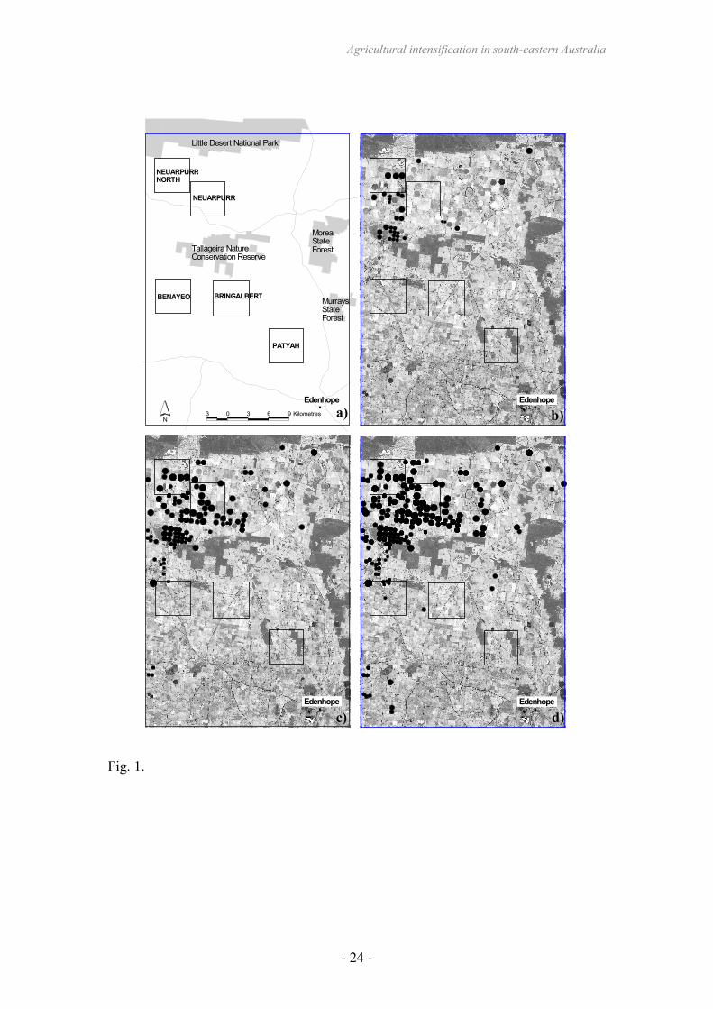
An area of 163,200 ha in the western part of the Wimmera bioregion in Victoria was
selected as a case study for this research (Fig. 1). The soils of the study area are
primarily fertile grey clays interspersed with low-fertility sandy ridges, with native
vegetation on the former soil types substantially modified or removed (Land
Conservation Council, 1985). Within this study area, five focal landscapes were
chosen to determine loss of scattered buloke (Allocasuarina luehmannii) trees
(Maron, 2005), which are of particular interest due to their importance to the
endangered red-tailed black-cockatoo (Maron and Lill, 2004) (Fig. 1).
2.2. Increase in centre pivots
The number and area of centre pivot irrigation areas (centre pivots) was determined
from analysis of satellite imagery and aerial photography for the years 1980, 1993,
1995, 2000, 2001 and 2005. Landsat MSS imagery was used for the 1980 analysis (50
m pixels), Landsat TM imagery (30 m pixels) was used for 1993 and 1995 analysis,
Landsat 7 EMR+ imagery (30 m pixels) was used for the 2000 analysis, SPOT
Panochromatic/Monochromatic imagery (10 m pixels) was used for the 2001 analysis
and ortho-rectified aerial photographs (0.6 m pixels) for the 2005 analysis. All active
pivots and evidence of previous pivots were first calculated from the 2005 images as
they provided the best resolution. The mapped areas were then compared to images
from the previous years and any pivots that were not evident at an earlier time deleted.
Due to the lower resolution of images earlier than 2001 it was not possible to
determine which pivot areas were in use at the time. Thus the calculations are
cumulative and represent the total area that had been used for centre pivots over the
Agricultural intensification in south-eastern Australia
- 8 -
period. Although the satellite imagery and aerial photography were gathered at
different times of the year and often over a time-frame of up to 12 months, for the
purposes of calculating annual increase in pivot numbers and area the data were
treated as though they were collected at the same time of the year. The area affected
by centre pivots in 2005 in relation to the modelled pre-1750 distribution of ecological
vegetation classes was calculated within ArcView GIS 3.3.
2.3. Loss of paddock trees
Rates of loss of paddock buloke trees between 1997-2005 were determined using the
five focal landscapes. Following the methods of Maron (2005), all buloke paddock
trees evident in each focal landscape were counted in the 2005 images and compared
with the number present in 1997. However, although both sets of images used in this
previous study were captured during summer, when grass residue was pale resulting
in a high contrast between trees and pasture/crop stubbles, the 2005 images were
captured at a time when the pasture grasses and crops were still green. This led to
increased difficulty in distinguishing the trees in some images, particularly that
depicting the Patyah landscape. In order to reduce error caused by omitting trees that
were present but poorly visible, transparencies used to mark all trees in the 1997
image were overlain on the 2005 images and each location where a tree was present in
1997 was individually checked for the presence of a tree in 2005. If there was
uncertainty about whether a particular tree was present in 2005, it was considered to
be present; thus, a conservative estimate of loss was made. Rates of loss from each
landscape were compared with those recorded between 1982/82 and 1997 (Maron,
2005).

Agricultural intensification in south-eastern Australia
- 9 -
3. Results
3.1. Changes in land use
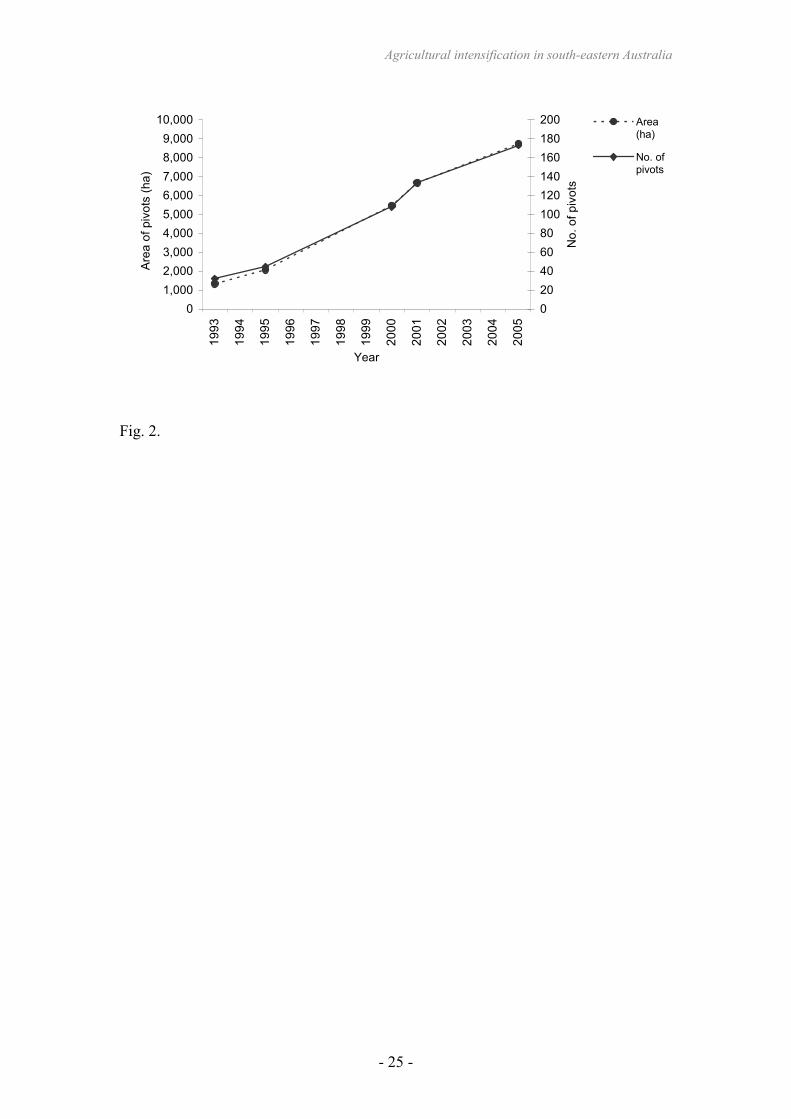
No evidence of centre pivots was visible on the 1980 images. However, several pivots
were present in the area in 1993 and the number of and area affected by centre pivots
increased steadily from 1993 to 2005 (Figs. 1 and 2). On average, 11.75 pivots
totalling 617 ha were established per year from 1993 to 2005, although between 2000
and 2005 13 new pivots at 651 ha were being established per year. Pivot areas
proliferated in the north of the study area, particularly in the region between the
Tallageira Nature Conservation Reserve and Little Desert National Park (Fig. 1). Few
were established in the south. The average size of pivots increased slightly from 41.7
ha in 1993 to 50.5 ha in 2005. By 2005, 8734 ha of the study area had been affected
by centre pivots, representing 5.5% of the area and up to 25% of the area between
Tallageira Nature Conservation Reserve and Little Desert National Park.
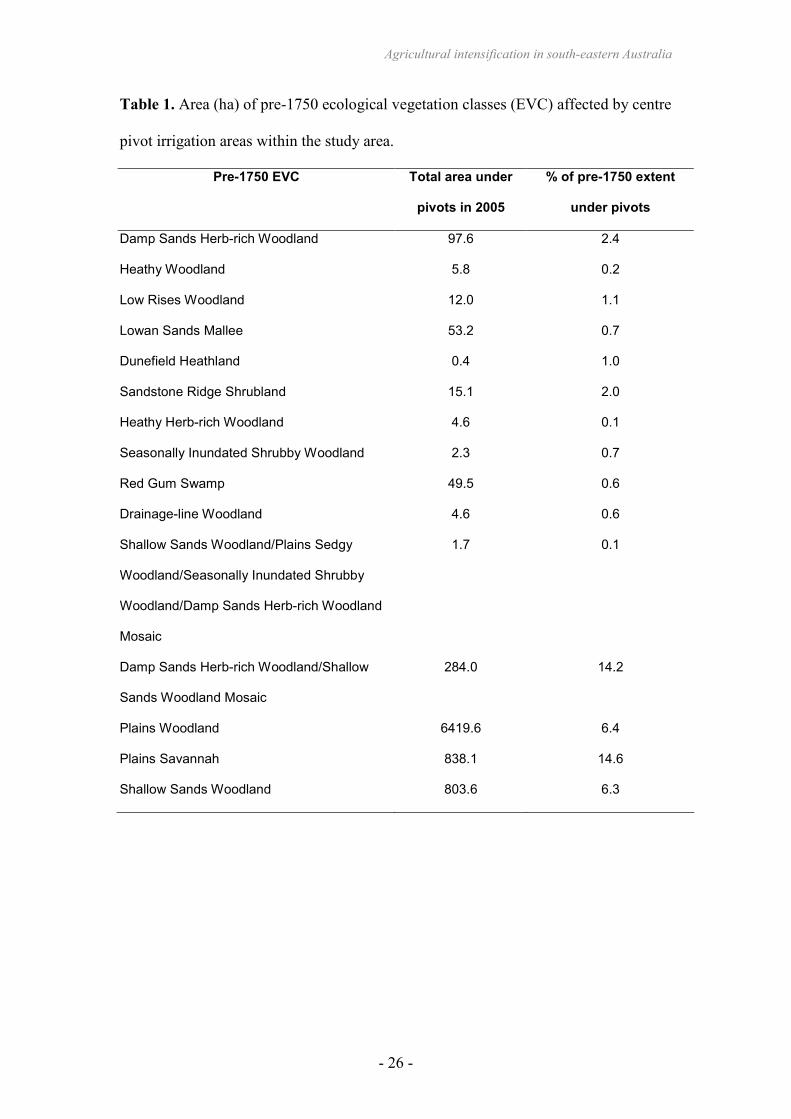
Areas which formerly supported the Plains Woodland ecological vegetation class
were the most heavily utilised for centre pivots, making up almost 75% of the total
area affected by pivots, while Plains Woodland, Plains Savannah and Shallow Sands
Woodland ecological vegetation classes combined made up almost 94% (Table 1). All
of these ecological vegetation classes have buloke as a dominant or co-dominant
overstorey species (Commonwealth and Victorian Regional Forest Agreement
Steering Committee, 2000; White et al., 2003).
3.2. Overall rates of tree loss
Agricultural intensification in south-eastern Australia
- 10 -
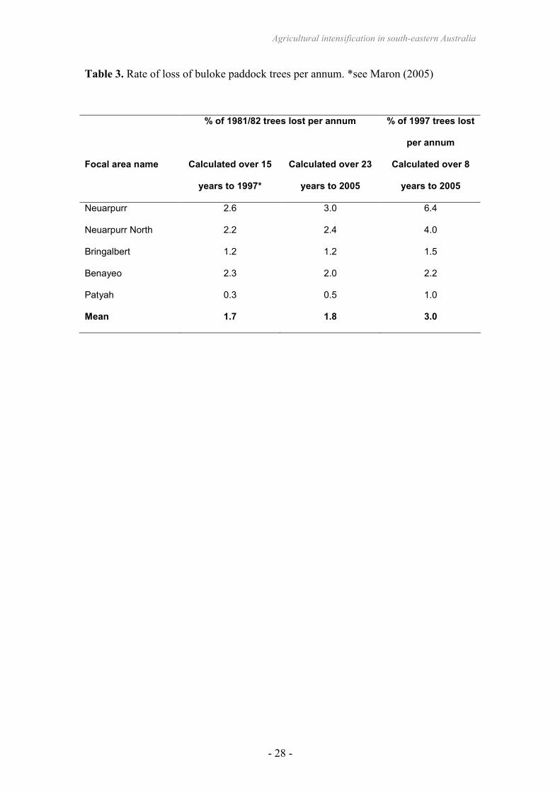
In the 15 years between 1981/82 and 1997, the average rate of loss of buloke trees
from paddocks in the five landscapes analysed had been 26% (Maron, 2005). In the
23 years to 2005, this figure was 42%. In the most affected landscape, 70% of trees
that were present in paddocks in 1981/82 had been lost by 2005 (Table 2).
The per annum rate of loss of paddock buloke trees, expressed as a percentage of trees
present in 1981/82, was higher when calculated over the 23 years to 2005 than over
the 15 years to 1997 (Table 3). While Maron (2005) found an average annual rate of
loss of 1.7%, the rate of loss per annum since 1997 (calculated as a percentage of
1997 trees) was 3.0% (Table 3). This indicates that although the number of trees
remaining in the landscape is decreasing, the number being removed annually is not,
and therefore the annual percentage loss has more than doubled in comparison with
the period 1981/82-1997.
3.3. Impact of land use on tree loss
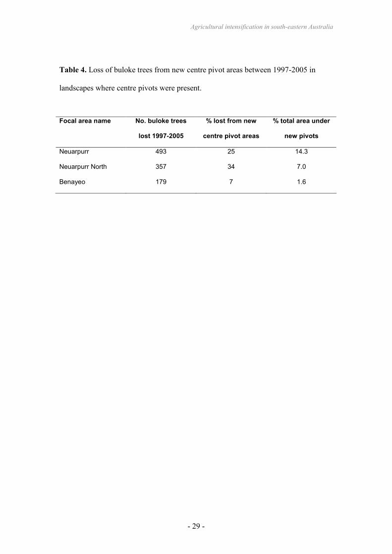
New centre pivot irrigation systems that had not been present in 1997 were evident in
three of the five landscapes in 2005. These developments contributed
disproportionately to the loss of paddock buloke trees. Although these new pivots
affected an average of 7.6% of these three landscapes, they accounted for an average
22% of the bulokes lost since 1997 (Table 4).
Due to the time of year at which the images were taken (spring) pasture could not
always be reliably distinguished from cropland. However, the Neuarpurr and
Neuarpurr North landscapes were predominantly cropland in 1997 and personal
observations in the study area confirm that this remained the case in the five years to
Agricultural intensification in south-eastern Australia
- 11 -
2005. The Benayeo landscape in the five years to 2005 was observed to have become
predominated by dryland cropping. The Patyah landscape consists of pasture with
very little cropping, while the Bringalbert landscape hosts a mix of cropping and
pasture. The mean overall loss of trees from the three cropping landscapes, at 56.8%,
is substantially higher than the Bringalbert (mixed cropping and grazing) landscape
(28%) and the Patyah (grazing only) landscape (11.7%) (Table 2).
Agricultural intensification in south-eastern Australia
- 12 -
4. Discussion
Agricultural intensification, rather than the conversion of new areas to agriculture, has
been responsible for most of the increase in food production over the past 30 years
(United Nations Food and Agriculture Organization, 2006). Such intensification has
resulted in substantial landscape change, and the resultant negative impacts on native
biota are more recently becoming evident (Donald et al., 2001; Soderstrom et al.,
2003). Continuing growth of centre pivot irrigation is likely to result in markedly
changed landscapes, with the removal of the majority of woody native vegetation
from the agricultural matrix. In the current study, the area affected by centre pivots
increased linearly to cover 5.5% of the study area over the 23 years to 2005. At a
more localised scale, centre pivots occupied as much as 25% of the area between the
Tallageira Nature Conservation Reserve and the Little Desert National Park. This
trend appears to be more widespread, as similar increases in centre pivots were
evident in adjoining parts of the Wimmera bioregion in South Australia.
Although the groundwater accessed in the study area has been fully allocated since
1996 there has been no reduction in the rate of increase in area affected by centre
pivots because the pivot arms are frequently moved to new paddocks with the original
site used for the centre pivot returned, temporarily or permanently, to dryland
cropping or grazing (C. Guest, personal communication, 2006). Agricultural practices
such as grazing and tillage prevent the regeneration of native vegetation on sites
cleared for centre pivot irrigators. Therefore, although tree removal at one pivot site
might involve only a few dozen trees, the cumulative impact as centre pivots are
moved represents a substantial loss of matrix habitat on a regional scale.
Agricultural intensification in south-eastern Australia
- 13 -
This alteration in matrix habitat is likely to have had a substantial impact on the
biodiversity of the region. Manning et al. (2006) refer to scattered paddock trees as
‘keystone structures’ due to their disproportionately large contribution to ecosystem
function. In the Wimmera, the scattered buloke trees provide a critical food resource
to an endangered specialist granivore, the south-eastern red-tailed black-cockatoo,
which feeds only on the seeds of three tree species (Joseph, 1982; Maron and Lill,
2004). Scattered trees in agricultural land also act as focal foraging sites for
microchiropteran bats (Lumsden and Bennett, 2005) and their role as host to
mistletoes (including, in the case of buloke, the vulnerable buloke mistletoe Amyema
linophylla) makes them likely nesting sites for a suite of declining bird species and
sources of high-nutrient litter fall (Watson, 2001; Cooney et al., 2006). They also
often represent the remnants of threatened vegetation communities (Gibbons and
Boak, 2002).
In addition to local-scale habitat alteration, changes in the agricultural matrix can
influence landscape-scale processes. The loss of paddock trees and other forms of
matrix homogenisation, such as conversion from native perennial pastures to
introduced annuals, results in an increase in patch/matrix contrast, potentially
influencing use of remnant patches and decreasing the ability of some organisms to
traverse the landscape. Lower genetic diversity in skink populations has been
attributed to attributes of the matrix surrounding habitat patches, suggesting that skink
dispersal through a homogeneous exotic pasture matrix is reduced compared with a
matrix of native tussock grassland (Berry et al., 2005). Castellon and Sieving (2005)
recorded reduced dispersal of an understorey rainforest bird from wooded patches
surrounded by open habitat than those surrounded by shrubby vegetation. Measures
Agricultural intensification in south-eastern Australia
- 14 -
that manage matrix permeability may reduce the influence of fragmentation
(Antongiovanni and Metzger, 2005). Improvements in matrix quality may be similarly
effective at providing landscape connectivity as creation or retention of vegetation
corridors (Castellon and Sieving, 2005).
The introduction of irrigation can itself have a negative effect on birds, especially
those of open grassy habitats (Brotons et al., 2004). Irrigation and intensive
management of areas previously subject to dryland agriculture results in changes to
the spatial and temporal distribution of resources, through reduced prey habitat in the
form of pasture or crop stubbles (McCracken and Tallowin, 2004). In Australia, bird
species such as spotted harrier (Circus assimilis), little button-quail (Turnix velox),
and plains-wanderer (Pedionomus torquatus), which are listed as threatened or near
threatened at national or state levels (Department of Sustainability & Environment,
2003), are likely to be negatively affected by habitat change from previously open
grassy woodland with extensive grazing and cereal cropping to intensive irrigated
cropping.
The increase in centre pivot irrigation is effectively accelerating habitat loss in a
region where tree decline through stubble burning, nutrification and natural
senescence with little regeneration already are occurring (Maron, 2005). In an earlier
study of the five focal areas, Maron (2005) recorded substantially lower annual rates
of tree loss for the fifteen-year period to 1997 than we found in the eight years to
2005, despite native vegetation clearing controls being in place since 1989 with more
recent policy intended to provide some protection for paddock trees introduced in
2002 (State of Victoria, 2002). The rates of tree loss recorded in this study are also
Agricultural intensification in south-eastern Australia
- 15 -
higher than those recorded in other recent studies of agricultural regions (Ozolins et
al., 2001; Carruthers, 2005). For example, Carruthers (2005) reported an annual rate
of loss of 0.5% compared to the average 1.8% over the 23 years of this study. If the
3.0% annual rate of loss detected over the eight years to 2005 continues, paddock
bulokes will be all but absent from the area within approximately 25 years, although it
is likely that trees in some landscapes (such as those in which the predominant land
use is sheep grazing) will be retained longer.
The loss of paddock trees and other matrix habitat has not often been quantified in the
past, with the focus mainly on broadscale clearing of intact native vegetation.
Australian native vegetation legislation does not adequately provide for the loss of
matrix habitat through intensification of land use, yet this is a major threat to
biodiversity. The buloke grassy woodlands of the Wimmera are part of a vegetation
community listed as threatened under the Commonwealth and State legislation.
However, as this once widespread community is now restricted primarily to paddock
trees within a matrix of pastoral and irrigated land with predominantly non-native
understorey, the trees themselves are not afforded the level of protection they would
receive if they occurred within a remnant patch.
In Europe and the United States, agri-environment schemes have been widely used in
attempts to mitigate the negative impacts of agricultural intensification and restore
matrix habitat (Donald and Evans, 2006). Primary producers are paid to employ more
environmentally-friendly practices, which often include maintaining a more
heterogeneous matrix through restoring field margins and reducing herbicide use.
Should such schemes be introduced in Australia, compensation of land managers for
Agricultural intensification in south-eastern Australia
- 16 -
extending matrix management to the protection of scattered paddock trees has the
potential to create benefits for native wildlife on a landscape scale.
We recommend that consideration be given to the impacts of agricultural
intensification on biodiversity in Australia. Although legislation to cease broad-scale
clearing has been introduced in most states and territories, Australia potentially faces
a second wave of local extinctions and species declines due to the continuing loss of
matrix habitat. While centre pivot irrigation is preferable in terms of water efficiency
compared with practices such as flood irrigation, the potential impacts on native biota
of introducing it to previously non-irrigated areas warrant attention. Landscape
planners in affected regions should consider activities to mitigate and offset the
effects of matrix habitat change, potentially through retaining and replanting paddock
trees wherever possible, and utilising the corners of centre pivot paddocks for
revegetation.
Agricultural intensification in south-eastern Australia
- 17 -
Acknowledgements
Initial data collection for this research was part-funded by the Victorian Department
of Sustainability & Environment. The Wimmera Catchment Management Authority
and Department of Sustainability & Environment provided aerial photographs and
satellite images. Peter Menkhorst provided advice and project support. Peter
Menkhorst, Denis Saunders and two anonymous referees provided helpful comments
on earlier drafts. Chris Guest of GWM Water provided information on centre pivot
irrigation practices.
Agricultural intensification in south-eastern Australia
- 18 -
References
Antongiovanni, M., Metzger, J.P., 2005. Influence of matrix habitats on the
occurrence of insectivorous bird species in Amazonian forest fragments.
Biological Conservation 122, 441–451.
Baum, K.A., Haynes, K.J., Forrest, P., Cronin, J.T., 2004. The matrix enhances the
effectiveness of corridors and stepping stones. Ecology 85, 2671–2676.
Berry, O., Tocher, M.D., Gleeson, D.M., Sarre, S.D., 2005. Effect of vegetation
matrix on animal dispersal: genetic evidence from a study of endangered skinks.
Conservation Biology 19, 855–864.
Brotons, L., MaÑosa, S., Estrada, J., 2004. Modelling the effects of irrigation schemes
on the distribution of steppe birds in Mediterranean farmland. Biodiversity and
Conservation 13, 1039–1058.
Carruthers, S., 2005. A Landscape Approach to Determine the Ecological Value of
Paddock Trees. Available from:
<http://www.dwlbc.sa.gov.au/files/NVlandscapeapproachpaddocktrees_2005.pdf>
Castellón, T.D., Sieving, K.E., 2006. An experimental test of matrix permeability and
corridor use by an endemic understorey bird. Conservation Biology 20, 135–145.
Chamberlain, D.E., Fuller, R.J., Bunce, R.G.H., Duckworth, J.C., Shrubb, M., 2000.
Changes in the abundance of farmland birds in relation to in the timing of
agricultural intensification in England and Wales. Journal of Applied Ecology 37,
771–788.
Cooney, S.J.N., Watson, D.M., Young, J., 2006. Mistletoe nesting in Australian birds:
a review. Emu 106, 1–12
Commonwealth and Victorian Regional Forest Agreement Steering Committee, 2000.
West Victoria Comprehensive Regional Assessment: Biodiversity Assessment.
Agricultural intensification in south-eastern Australia
- 19 -
Commonwealth and Victorian Regional Forest Agreement Steering Committee,
Canberra.
Department of Sustainability & Environment, 2003. Advisory List of Threatened
Vertebrate Fauna in Victoria – 2003. Department of Sustainability &
Environment, Melbourne.
Donald, P.F., Evans, A.D., 2006. Habitat connectivity and matrix restoration: the
wider implications of agri-environment schemes. Journal of Applied Ecology 43,
209–218.
Donald, P.F., Green, R.E. Heath, M.F., 2001. Agricultural intensification and the
collapse of Europe’s farmland bird populations. Proceedings of the Royal Society
of London B 268, 25–29.
Eggleton, P., Vanbergen, A.J., Jones, D.T., Lambert, M.C., Rockett, C., Hammond,
P.M., Beccaloni, J., Marriott, D., Ross, E., Giusti, A., 2005. Assemblages of soil
macrofauna across a Scottish land-use intensification gradient: influences of
habitat quality, heterogeneity and area. Journal of Applied Ecology 42, 1153–
1164.
Fischer, J., Lindenmayer, D.B., 2002. The conservation value of paddock trees for
birds in a variegated landscape in southern New South Wales. 2. Paddock trees as
stepping stones. Biodiversity and Conservation 11, 833–849.
Fuller, R.J., Gregory, R.D., Gibbons, D.W., Marchant, J.H., Wilson, J.D., Baillie,
S.R., Carter, N., 1995. Population declines and range contractions among lowland
farmland birds in Britain. Conservation Biology 9, 1425–1441.
Gibbons, P., Boak, M., 2002. The value of paddock trees for regional conservation in
an agricultural landscape. Ecological Management & Restoration 3, 205–210.
Agricultural intensification in south-eastern Australia
- 20 -
Joseph, L., 1982. The red-tailed black-cockatoo in south-eastern Australia. Emu 82,
46–49.
Land Conservation Council, 1985. Report on the Wimmera Area. Land Conservation
Council, Melbourne.
Law, B., Chidel, M., Turner, G., 2000. The use by wildlife of paddock trees in
farmland. Pacific Conservation Biology 6, 130–143.
Lumsden, L.F., Bennett, A.F., 2005. Scattered trees in rural landscapes: foraging
habitat for insectivorous bats in southeastern Australia. Biological Conservation
122, 205–222.
Lumsden, L.F., Bennett, A.F., Silins, J.E., 2002. Location of roosts of the lesser long-
eared bat Nyctophilus geoffroyi and Gould’s wattled bat Chalinolobus gouldii in a
fragmented landscape in south-eastern Australia. Biological Conservation 106,
237–249.
Manning, A.D., Fischer, J., Lindenmayer, D.B., 2006. Scattered trees are keystone
structures – Implications for conservation. Biological Conservation 132, 311-321
Manning, A.D., Lindenmayer, D.B., Barry, S.C., 2004. The conservation implications
of bird reproduction in the agricultural “matrix”: a case study of the vulnerable
superb parrot of south-eastern Australia. Biological Conservation 120, 363–374.
Mansergh, I., Anderson, H., Amos, N., 2006. Victoria’s living Natural Capital –
decline and replenishment 1800–2050. Part 2 – The new millennium:
replenishment. Victorian Naturalist 123, 288–313.
Maron, M., 2005. Agricultural change and paddock tree loss: Implications for an
endangered subspecies of Red-tailed Black-Cockatoo. Ecological Management
and Restoration 6, 206–211.
Agricultural intensification in south-eastern Australia
- 21 -
Maron, M., Burnard, T., Kirkwood, J., 2005. Buloke Woodlands: Flora and Fauna
Guide for the Wimmera. WWF-Australia, Sydney.
Maron, M., Lill, A., 2004. Discrimination among potential buloke (Allocasuarina
luehmannii) feeding trees by the endangered south-eastern red-tailed black-
cockatoo (Calyptorhynchus banksii graptogyne). Wildlife Research 31, 311–317.
McCracken, D.I., Tallowin, J.R., 2004. Swards and structure: the interactions between
farming practices and bird food resources in lowland grasslands. Ibis 146(S2),
108–114.
Newton, I., 2004. The recent declines of farmland bird populations in Britain. An
appraisal of causal factors and conservation actions. Ibis 146, 579–600.
Oliver, I., Pearce, S., Greenslade, P.J.M., Britton, D.R., 2006. Contribution of
paddock trees to the conservation of terrestrial invertebrate biodiversity within
grazed native pastures. Austral Ecology 31, 1–12.
Ozolins A., Brack C., Freudenberger, D., 2001. Abundance and decline of isolated
trees in the agricultural landscapes of Central New South Wales. Pacific
Conservation Biology 7, 195–203.
Söderström, B., Kiema, S., Reid, R.S., 2003. intensified agricultural land-use and bird
conservation in Burkina Faso. Agriculture, Ecosystems and Environment 99, 113–
124.
State of Victoria, 2002. Victoria’s Native Vegetation Management - A Framework for
Action. State of Victoria, Melbourne.
Teeluk, M., 1997. Development of the centre pivot irrigation system in Mauritius.
Food and Agriculture Research Council, Reduit, Mauritius. Available from:
<http://www.gov.mu/portal/sites/ncb/moa/farc/amas97/pdf/msiri06.pdf>
Agricultural intensification in south-eastern Australia
- 22 -
Tscharntke, T., Klein, A.M., Kruess, A., Steffan-Dewenter, I., Thies, C., 2005.
Landscape perspectives on agricultural intensification and biodiversity –
ecosystem service management. Ecology Letters 8, 857–874.
United Nations Food and Agriculture Organization, 2006. FAOSTAT. United Nations
Food and Agriculture Organization. Available from: <http://faostat.fao.org>,
accessed 29 Sept 2006.
Wilson, B., 2002. Influence of scattered paddock trees on surface soil properties: a
study of the Northern Tablelands of NSW. Ecological Management and
Restoration 3, 211–219.
Watson, D.M., 2001. Mistletoe – a keystone resource in forests and woodlands
worldwide. Annual Review of Ecology and Systematics 32, 219–249.
White, M., Oates, A., Barlow, T., Pelikan, M., Brown, J., Rosengren, N., Cheal, D.,
Sinclair, S., Sutter, G., 2003. The Vegetation of North-West Victoria. A Report to
the Wimmera, North Central and Mallee Catchment Management Authorities.
Department of Sustainability and Environment, Melbourne.
Agricultural intensification in south-eastern Australia
- 23 -
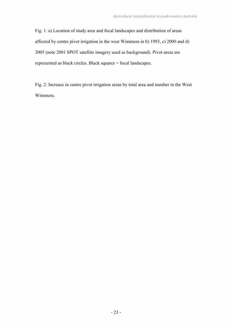
Fig. 1. a) Location of study area and focal landscapes and distribution of areas
affected by centre pivot irrigation in the west Wimmera in b) 1993, c) 2000 and d)
2005 (note 2001 SPOT satellite imagery used as background). Pivot areas are
represented as black circles. Black squares = focal landscapes.
Fig. 2. Increase in centre pivot irrigation areas by total area and number in the West
Wimmera.
Agricultural intensification in south-eastern Australia
- 24 -
Fig. 1.
L i t t l e D e s e r t N a tio n a l Pa r k
T a l la g e i r a N a t u r e C o n s e r v a ti o n
R e s e r v e
M o r e a St a t e F o r e s t
M u r r a y s S t a t e
F o r e s t
% E d e n h o p e
P A TY A H
B R I N GA L B E RTB E N A Y E O
N E U A R P U R R
N E U A R P U R R N O RTH
3 0 3 6 9 Kil o me tr e s N
% E d e n h o p e
% E d e n h o p e % E d e n h o p e
a) b)
c) d)
Agricultural intensification in south-eastern Australia
- 25 -
Fig. 2.
0
1,000
2,000
3,000
4,000
5,000
6,000
7,000
8,000
9,000
10,000
1993
1994
1995
1996
1997
1998
1999
2000
2001
2002
2003
2004
2005
Year
Area of pivots (ha)
0
20
40
60
80
100
120
140
160
180
200
No. of pivots
Area(ha)
No. ofpivots
Agricultural intensification in south-eastern Australia
- 26 -
Table 1. Area (ha) of pre-1750 ecological vegetation classes (EVC) affected by centre
pivot irrigation areas within the study area.
Pre-1750 EVC Total area under
pivots in 2005
% of pre-1750 extent
under pivots
Damp Sands Herb-rich Woodland 97.6 2.4
Heathy Woodland 5.8 0.2
Low Rises Woodland 12.0 1.1
Lowan Sands Mallee 53.2 0.7
Dunefield Heathland 0.4 1.0
Sandstone Ridge Shrubland 15.1 2.0
Heathy Herb-rich Woodland 4.6 0.1
Seasonally Inundated Shrubby Woodland 2.3 0.7
Red Gum Swamp 49.5 0.6
Drainage-line Woodland 4.6 0.6
Shallow Sands Woodland/Plains Sedgy
Woodland/Seasonally Inundated Shrubby
Woodland/Damp Sands Herb-rich Woodland
Mosaic
1.7 0.1
Damp Sands Herb-rich Woodland/Shallow
Sands Woodland Mosaic
284.0 14.2
Plains Woodland 6419.6 6.4
Plains Savannah 838.1 14.6
Shallow Sands Woodland 803.6 6.3
Agricultural intensification in south-eastern Australia
- 27 -
Table 2. Loss of paddock buloke trees since 1981/82 in the five focal landscapes
* after Maron (2005)
No. buloke trees
Focal area
name
Area (ha) 1981/82* 2005 No. lost % loss since
1981/82
Neuarpurr 2320 1586 476 1110 70.0
Neuarpurr North 2060 1662 759 903 54.3
Bringalbert 1440 4257 3064 1193 28.0
Benayeo 1500 1554 837 717 46.1
Patyah 530 411 363 48 11.7
Mean±SD 42.0±10.2
Total 7850 9470 5499 2503
Agricultural intensification in south-eastern Australia
- 28 -
Table 3. Rate of loss of buloke paddock trees per annum. *see Maron (2005)
% of 1981/82 trees lost per annum % of 1997 trees lost
per annum
Focal area name Calculated over 15
years to 1997*
Calculated over 23
years to 2005
Calculated over 8
years to 2005
Neuarpurr 2.6 3.0 6.4
Neuarpurr North 2.2 2.4 4.0
Bringalbert 1.2 1.2 1.5
Benayeo 2.3 2.0 2.2
Patyah 0.3 0.5 1.0
Mean 1.7 1.8 3.0
Agricultural intensification in south-eastern Australia
- 29 -
Table 4. Loss of buloke trees from new centre pivot areas between 1997-2005 in
landscapes where centre pivots were present.
Focal area name No. buloke trees
lost 1997-2005
% lost from new
centre pivot areas
% total area under
new pivots
Neuarpurr 493 25 14.3
Neuarpurr North 357 34 7.0
Benayeo 179 7 1.6