Embed Size (px)
Citation preview

1
WEST AREA PLANNING COMMITTEE 13th March 2018
Application Number: 17/02537/FUL
Decision Due by: 26th December 2017
Extension of Time: 23rd March 2018
Proposal: Proposed demolition of existing buildings and redevelopment comprising: erection of new building to provide student accommodation (59 bedrooms), porters lodge, middle common room, fellows' accommodation and academic and administrative offices; erection of new pavilion building; removal of existing porch to old hall building and provision of replacement; creation of new pedestrian access from Cowley Place; replacement bin and bicycle parking.
Site Address: St Hilda's College, Cowley Place (site plan: appendix 1)
Ward: St Marys Ward
Case Officers N Dobraszczyk /A Murdoch
Agent: JPPC Applicant: St Hilda's College
Reason at Committee: Major Application
1. RECOMMENDATION
1.1. West Area Planning Committee is recommended to:
(a) Approve the application for the reasons given in the report and subject to the required planning conditions set out in section 11 of this report and grant planning permission subject to:
(b) Agree to delegate authority to the Head of Planning, Sustainable Development and Regulatory Services to:
1. Finalise the recommended conditions as set out in this report including such refinements, amendments, additions and/or deletions as the Head of Planning, Sustainable Development and Regulatory Services considers reasonably necessary;
11
Agenda Item 3

2
2. EXECUTIVE SUMMARY
2.1. This report considers an application for the demolition of existing buildings within the college campus, and the erection of a new building to provide student accommodation (59 bedrooms), porters lodge, middle common room, fellows' accommodation and academic and administrative offices; erection of new pavilion building; removal of existing porch to old hall building and provision of replacement; creation of new pedestrian access from Cowley Place; replacement bin and bicycle parking.
2.2. The key matters for assessment set out in this report include the following: Principle of development; Design & Impact upon Designated Heritage Assets; Impact on Neighbouring Amenity; Landscaping Transport Sustainability Flooding; Biodiversity Other Matters – Land contamination, archaeology, and air quality
2.3. The application has been developed following pre-application discussions with officers, including two reviews by the Oxford Design Review Panel. Copies of their comments are included within Appendix 2 of this report. The panel were supportive of the scheme and considered that the proposals would integrate well with the context and would improve the quality of the campus environment.
2.4. Officers consider that the proposal would accord with the policies of the development plan when considered as a whole and the range of material considerations on balance support the grant of planning permission.
2.5. The scheme would also accord with the aims and objectives of the National Planning Policy Framework would constitute sustainable development, and, given conformity with the development plan as a whole, paragraph 14 advises that the development proposal should be approved without delay. Furthermore there are not any material considerations that would outweigh the compliance with these national and local plan policies.
3. COMMUNITY INFRASTRUCTURE LEVY (CIL)
3.1. The proposal is liable for a CIL contribution of £53,750.18.
4. SITE AND SURROUNDINGS
4.1. The St Hilda’s College site is located within the St Clement’s and Iffley Road Conservation Area. The Central Conservation Area borders the college site to the north-west with its boundary following the line of the River Cherwell which itself forms the western boundary. Cowley Place forms its eastern boundary.
12
3
4.2. The site of St Hilda’s College comprises five grade II listed structures; The Old Hall, Library and the wall and gate piers which run parallel to Cowley Place, the piers and gates to the South Building, and the Garden Building sited to the south of the South Building. The other principle buildings on the site, namely the South Building, Milham Ford building and Porters Lodge are considered buildings of local significance which make a positive contribution to the conservation area.
4.3. Other surrounding listed buildings include 2 & 3 Cowley Place and the grade II listed Magdalen College School building on the corner of Cowley Place and The Plain.
4.4. The Grade I registered park and gardens of Christ Church and the Oxford Botanic Garden are situated to the north and west of St Hilda’s. The site is highly visible and prominent in views from these registered park and gardens, with views afforded across the open landscapes and rivers, interrupted only by the frequently broken line of trees along the river banks. Views of the site in the context of Magdalen Tower are seen from the Broad Walk in Christ Church. Glimpses of the site are also visible from the grade II* listed Magdalen Bridge. The site is visible in wider / more long distant views from key viewing points within the city, including St Mary’s Tower, where it is viewed in the context and setting of the grade I listed church, St John the Evangelist on Iffley Road.
4.5. Most of the application site is located within Flood Zones 1 with the exception of the proposed Pavilion Building which is located within Flood Zone 3.
4.6.A site location plan is included below:
© Crown Copyright and database right 2011.Ordnance Survey 100019348
13

4
5. PROPOSAL
5.1. The application proposes the demolition of the Milham Ford building, Porters Lodge, MCR, storage buildings, entrance gates and the existing porch to the Hall Building. It also proposes the redevelopment of this area comprising:
Erection of a part 4 storey, part 5 storey building on Cowley Place to provide student accommodation (59 bedrooms); new porters lodge; new middle common room; Fellows' accommodation and academic and administrative offices (‘The Boundary Building’);
Replacement porch to the Hall Building; Erection of new pavilion building; Creation of new pedestrian access from Cowley Place; Replacement bin and bicycle parking; Landscaping.
5.2. The proposed development will include 50 standard student bedrooms, 2 accessible student bedrooms and 7 visiting student bedrooms. The Gross Internal Area (GIA) of the existing Milham Ford Building is 885m2 and the GIA of the existing MCR/ Porters’ Lodge/ Lodge Manager’s Apartment is 369m2. The proposed Boundary Building development will demonstrate a GIA of 3,213m2. There are currently 293 cycle parking spaces provided on site. The application proposes the loss of 175 spaces with 118 covered cycle parking spaces will be provided within the red line boundary.
5.3. The College has currently 585 students of which 192 are graduates and 393 undergraduates. It currently provides accommodation for 246 undergraduate students in various properties both within the main site and in outlying areas, primarily the Iffley and Cowley Roads. The proposed development would enable the College to provide on-site accommodation for a further 32 undergraduate students who would otherwise take up accommodation in the City’s private housing stock.
5.4. The Boundary Building also includes a proposed tower element to be located on the eastern boundary of the site along Cowley Place. The tower element would stand at a height of 19.3 metres above street level with an additional 1.5 metre high decorative metal element sitting above the tower.
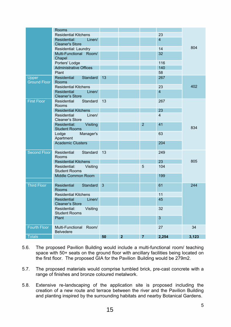
5.5. For clarity the proposed accommodation schedule for the Boundary Building is included below:
QuantityFloor Type
Stan
dard
R
oom
s
Acce
ssib
le
Roo
ms
Visi
ting
Stud
ent
Roo
ms
Area Per Type (m2)
Area Per Floor (m2)
Residential Standard Rooms
8 165Ground Floor
Residential Accessible 2 52
14
5
RoomsResidential Kitchens 23Residential: Linen/ Cleaner's Store
4
Residential: Laundry 14Multi-Functional Room/ Chapel
32
Porters' Lodge 116Administrative Offices 140Plant 58
804
Residential Standard Rooms
13 267
Residential Kitchens 23
Upper Ground Floor
Residential Linen/ Cleaner’s Store
4402
Residential Standard Rooms
13 267
Residential Kitchens 23Residential Linen/ Cleaner’s Store
4
Residential: Visiting Student Rooms
2 41
Lodge Manager's Apartment
63
First Floor
Academic Clusters 204
834
Residential Standard Rooms
13 249
Residential Kitchens 23Residential: Visiting Student Rooms
5 104
Second Floor
Middle Common Room 199
805
Residential Standard Rooms
3 61
Residential Kitchens 11Residential Linen/ Cleaner’s Store
45
Residential: Visiting Student Rooms
32
Third Floor
Plant 3
244
Fourth Floor Multi-Functional Room/ Belvedere
27 34
Totals 50 2 7 2,254 3,123
5.6. The proposed Pavilion Building would include a multi-functional room/ teaching space with 50+ seats on the ground floor with ancillary facilities being located on the first floor. The proposed GIA for the Pavilion Building would be 279m2.
5.7. The proposed materials would comprise tumbled brick, pre-cast concrete with a range of finishes and bronze coloured metalwork.
5.8. Extensive re-landscaping of the application site is proposed including the creation of a new route and terrace between the river and the Pavilion Building and planting inspired by the surrounding habitats and nearby Botanical Gardens.
15
6
5.9. Up-lighting of the tower element and a new tree along Cowley Place is proposed as well as external lighting along surface pathways and at entrances.
5.10. The application proposes to move the existing vehicle access from its location on Cowley Place further south west through the listed gates. This access would be used for emergency vehicles. The 18 existing car parking spaces provided on site would be lost with no re-provision as a result of the proposed development.
6. RELEVANT PLANNING HISTORY
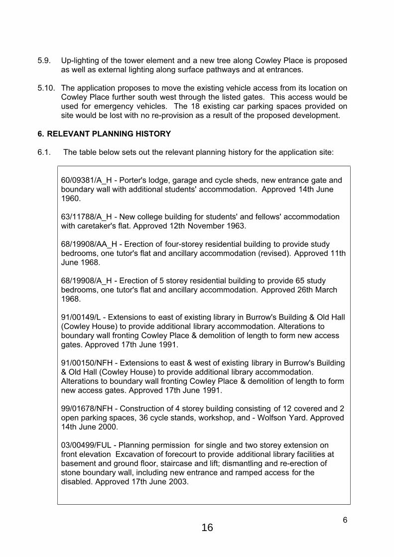
6.1. The table below sets out the relevant planning history for the application site:
60/09381/A_H - Porter's lodge, garage and cycle sheds, new entrance gate and boundary wall with additional students' accommodation. Approved 14th June 1960.
63/11788/A_H - New college building for students' and fellows' accommodation with caretaker's flat. Approved 12th November 1963.
68/19908/AA_H - Erection of four-storey residential building to provide study bedrooms, one tutor's flat and ancillary accommodation (revised). Approved 11th June 1968.
68/19908/A_H - Erection of 5 storey residential building to provide 65 study bedrooms, one tutor's flat and ancillary accommodation. Approved 26th March 1968.
91/00149/L - Extensions to east of existing library in Burrow's Building & Old Hall (Cowley House) to provide additional library accommodation. Alterations to boundary wall fronting Cowley Place & demolition of length to form new access gates. Approved 17th June 1991.
91/00150/NFH - Extensions to east & west of existing library in Burrow's Building & Old Hall (Cowley House) to provide additional library accommodation. Alterations to boundary wall fronting Cowley Place & demolition of length to form new access gates. Approved 17th June 1991.
99/01678/NFH - Construction of 4 storey building consisting of 12 covered and 2 open parking spaces, 36 cycle stands, workshop, and - Wolfson Yard. Approved 14th June 2000.
03/00499/FUL - Planning permission for single and two storey extension on front elevation Excavation of forecourt to provide additional library facilities at basement and ground floor, staircase and lift; dismantling and re-erection of stone boundary wall, including new entrance and ramped access for the disabled. Approved 17th June 2003.
16

7
17/02538/LBC - Removal of porch to Hall Building, MCR, Storage Buildings and Porters Lodge; erection of new bin and bicycle store and replacement porch to Hall Building. Connection of new boundary building to South Building Entrance gate piers. Pending Consideration.
6.2. On 18th May 2016 following a screening request, the Local Planning Authority issued confirmation that the proposed development would be classed as an “urban development project” under paragraph 10 (b) of Schedule 2 of the Environmental Impact Assessment (EIA) Regulations (2015). The site was not found to be within a “sensitive area” and the site area is below the 1ha threshold for this type of development. As such, Officers concluded that the development would not constitute Schedule 2 development which required screening as to whether an EIA should be required.
7. RELEVANT PLANNING POLICY 7.1. The following policies are relevant to the application:
Topic National Planning Policy Framework (NPPF)
Local Plan Core Strategy
Sites and Housing Plan
Other Planning Documents
Design 7(Paragraphs 56 – 68)
CP1, CP8, CP9,
CS18_, HP9_,
Conservation/ Heritage
(Paragraphs 126 – 141)
HE2, HE3, HE7, HE8, HE9, HE10,
Housing 6(Paragraphs 47 – 55)
CP6, CP10, CS2_, CS25_,
HP5_, HP6_,
Natural Environment
11(Paragraphs 79 -92); 11 (Paragraphs 109 – 125)
CP11, CP17, CP18, NE15, NE16, NE21, NE23, CP23,
CS9_, CS11_, CS12_,
Social and community
8(Paragraphs 69 – 78)
CS19_, CS29_,
Transport 4(Paragraphs 29 – 41)
TR1, TR2, TR12
CS13_, HP15_, Parking Standards SPD
17
8
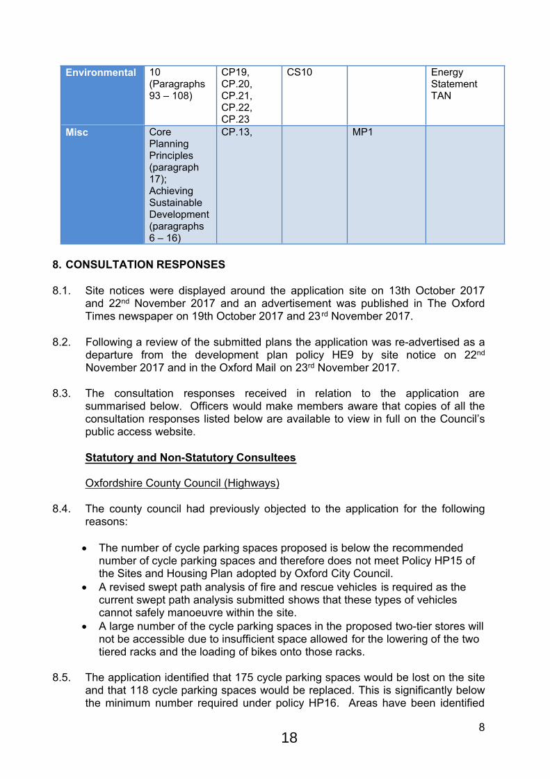
Environmental 10(Paragraphs 93 – 108)
CP19,CP.20, CP.21, CP.22, CP.23
CS10 Energy Statement TAN
Misc Core Planning Principles (paragraph 17); Achieving Sustainable Development (paragraphs 6 – 16)
CP.13, MP1
8. CONSULTATION RESPONSES
8.1. Site notices were displayed around the application site on 13th October 2017 and 22nd November 2017 and an advertisement was published in The Oxford Times newspaper on 19th October 2017 and 23 rd November 2017.
8.2. Following a review of the submitted plans the application was re-advertised as a departure from the development plan policy HE9 by site notice on 22nd November 2017 and in the Oxford Mail on 23rd November 2017.
8.3. The consultation responses received in relation to the application are summarised below. Officers would make members aware that copies of all the consultation responses listed below are available to view in full on the Council’s public access website.
Statutory and Non-Statutory Consultees
Oxfordshire County Council (Highways)
8.4. The county council had previously objected to the application for the following reasons:
The number of cycle parking spaces proposed is below the recommended number of cycle parking spaces and therefore does not meet Policy HP15 of the Sites and Housing Plan adopted by Oxford City Council.
A revised swept path analysis of fire and rescue vehicles is required as the current swept path analysis submitted shows that these types of vehicles cannot safely manoeuvre within the site.
A large number of the cycle parking spaces in the proposed two-tier stores will not be accessible due to insufficient space allowed for the lowering of the two tiered racks and the loading of bikes onto those racks.
8.5. The application identified that 175 cycle parking spaces would be lost on the site and that 118 cycle parking spaces would be replaced. This is significantly below the minimum number required under policy HP16. Areas have been identified
18
9
for the re-provision of the lost spaces, raising the total provision to 316 cycle parking spaces. The county council would welcome such a provision and is agreeable to the approach that the development should not commence until details of such a provision have been approved in writing and the schemes implemented.
8.6. Further details have also been submitted to demonstrate that the specific type of two-tier cycle parking racks to be installed within the proposed bicycle store can be accommodated within the dimensions of that store according to the manufacturer’s specifications.
8.7. An updated site plan showing a swept path analysis for the manoeuvring of fire and refuse vehicles within the site has been submitted. This demonstrates that such a vehicle can safely enter and turn within the site and reach a point within 45m of the pavilion.
8.8. For these reasons the county council no longer objects to the application.
Historic England
8.9. This application has been submitted following extensive pre-application discussions with Oxford City Council, CABE and ourselves.
8.10. The proposals involve rationalising the College’s entrance, teaching and student accommodation by dramatically altering the central portion of the riverside buildings. To do this three existing buildings, The Lodge, MCR and the 19th
century Milham Ford building would be demolished. None are of any great architectural merit; though the lodge by Richardson and Houfe is a competent neo-classical design but it is not outstanding. Their loss would cause some harm to the significance of the conservation area because the story of St Hilda’s occupation of the site and the way they appropriated earlier buildings would be compromised. However, we assess the level of harm entailed by their demolition to be low and think this is justified by the very real need to rationalise the space to meet the College’s needs.
8.11. In their place two larger buildings are proposed. The first would be a three/four storey building containing a porters lodge, student and fellows sets, an MCR and a function room in a tower. The building would have a kinked footprint which followed the line of Cowley Place with the tower placed on the east side beside the porters’ lodge. The scale of this building would be would be on a par with the adjacent riverside villas, though the tower would be higher. The second building is a riverside pavilion with function and teaching rooms.
8.12. The design of the new buildings has been refined during the pre-application process and is now an elegant and attractive set of buildings which is well adapted to its context. Particular attention has been given to the tower, which has been reduced in bulk and the elevational treatments have become much more coherent. We now are content that has assumed an appropriate form and could be a welcome addition to Oxford’s skyline.
19
10
8.13. The decorative treatment on the top of the tower needs further refinement. Topping the tower with sculptural decoration of a diaphanous nature that would catch the light has great potential and could make this building truly distinctive but the form it takes in current illustrations is not wholly satisfactory. It feels a little too insubstantial and does not relate well enough to the rest of the elevation, making the composition as a whole appear a little incoherent. We are aware that this aspect of the design is still in development. As this is the only element of the proposals we are concerned about and it is the form rather than the principle of a decorative cap that needs resolving we would be content with this issue to be dealt with by condition should the Council resolve to grant planning permission.
8.14. Historic England has no objection to the applications on heritage grounds and consider the applications meet the requirements of the NPPF, in particular paragraph numbers 17, 131, 132 and 134. In determining these applications you should bear in mind the statutory duty of sections 16(2) and 66(1) of the Planning (Listed Buildings and Conservation Areas) Act 1990 to have special regard to the desirability of preserving listed buildings or their setting or any features of special architectural or historic interest which they possess and section 72(1) of the Planning (Listed Buildings and Conservation Areas) Act 1990 to pay special attention to the desirability of preserving or enhancing the character or appearance of conservation areas.
Environment Agency
8.15. No objections to the proposal in terms of flood risk subject to a condition requiring the proposal to be carried out in accordance with the submitted Flood Risk Assessment.
8.16. The Agency has raised an objection on ecological grounds as the proposals offer no ecological buffer between the River Cherwell and development. It has advised that the objection may be overcome if the development was moved back from the bank to provide a small high value buffer.
8.17. NB: It is understood that the Environment Agency have removed their objection following discussions with the applicant regarding the provision of some biodiversity enhancements within the river. A copy of their updated response has not been provided at the time of publishing this report. Officers will update members verbally at the meeting.
Natural England
8.18. Natural England has raised no objection to the proposal.
Public representations
Twentieth Century Society
8.19. Expressed concerns at the loss of the Milham Ford buildings, especially the river elevation. It was felt that the porch on the Hall Building should be retained in situ as it ties different periods of development together across the College site.
20

11
Victorian Group of the Oxford Architectural and Historical Society
8.20. Objected to the proposals on the basis that they would contrast with the existing buildings and would be at odds with the sensitive nature of the site. It was felt that the existing Porter’s Lodge and Milham Ford Building represent attractive and significant works by Sir Albert Richardson. The comments also state that the existing porch on the Hall Building should be retained and not removed as proposed.
Oxford Preservation Trust
8.21. Commented that the application needed to be advertised as a departure from the development plan due to the height of the proposed tower element which would conflict with Local Plan Policy HE.9 (High Buildings).
8.22. The Trust understand and support St Hilda’s aspiration to having a better presence and sense of arrival, and have reviewed the documentation in a positive way to assess the impact of what is proposed. The Trust is not opposed to the principle of new spires or towers being added to the Oxford skyline, but any such addition needs to be handled with greatest care. It should be of an exceptional design; it should also make a positive contribution to the views of the dreaming spires of Oxford when viewed from anywhere within and outside Oxford and should also enhance the setting of the Central Conservation Area.
8.23. The existing towers and spires of Oxford are solid stone and robust structures in character, bell towers and spires. If they are lit then they are done so externally. The St Hilda’s tower differs in design to Magdalen Tower. The latter is a bell tower akin to a church tower, and has external lighting and no internal accommodation. St Hilda’s appears to be designed as a ‘beacon’ to shine out. It is different in character and therefore a full assessment of the night time impact within the view is needed and whether this would harm the view which forms the setting of the Central Conservation Area. The Trust is also concerned that this Tower will adversely impact on the character and public’s enjoyment of Christ Church Meadows and the Botanic Gardens in the day and into evening.
8.24. The Heritage Statement has underestimated the impact upon the highly significant heritage assets. For the college to create a greater presence and sense of arrival, requires a significant and bold piece of architecture which, no matter how sympathetic and acceptable the proposals might be of themselves, will have a significant impact on heritage assets located in close proximity to the site. The Trust are concerned that the LVIA assesses the impact of the development from a landscape and not a heritage viewpoint. The assessment should have been based on the Assessment of the Oxford View Cones (2015) document, which provides a better methodology to assess visual effects of new development.
8.25. The NPPF para 132 states that the more important the asset, the greater weight should be given to its conservation. Significance can be harmed or lost through alteration or destruction of the heritage asset or development within its setting.
21

12
The PPG provides more detailed advice as to how the assessment of the level of harm impacts upon the significance of the asset, rather than the size of the development. In this case we would advise the Council of case law (Barnwell Manor) which drew attention to the importance and significance of the setting of a heritage asset.
8.26. The LVIA suggests that the proposed development will not be visible from South Park. This is not correct. The description on Page 35 of the LVIA does not seem to accord with View 7, as it refers to ‘The Christ Church group of buildings is seen as an uninterrupted view’, yet this is not visible in the photo. The words describe the view as having an overall rating of ‘Very High’ Visual Sensitivity, yet it is not possible to see the trio of Christ Church Towers and therefore assess the impact that the proposals may have on this important cluster. We are concerned that the proposed tower may well sit in the middle of this cluster but without this proper assessment and view, it is impossible to determine whether this is the case and, if it is, what the impact it will have in heritage terms. We ask that this view is redone.
8.27. Christ Church Meadows and the Botanic Gardens are Grade I registered Park and Gardens of national importance which the City Council endeavour to protect in the current Oxford Local Plan, 2001-2016 through Policy HE.8 (Important Parks and Gardens) which states planning permission will not be granted for any development that will adversely affect the visual, historical or horticultural character of an historic park or garden, or its setting.’ It is clear from photo visual View 9 through to View 15 and subsequently View 23 from the LVIA photography, that there will be varying degrees of impact on these designated heritage assets. However, in the views chosen, the development is diminished in height and bulk. In OPT’s view, these proposals will sit up prominently and appear as a large block in the back drop of both of these registered park and gardens. In order for any adverse effects to be fully considered, we ask for these views to be retaken and to depict what the eye truly sees in these locations.
8.28. View 28 (Appendix 3) from St Mary’s on the High is also concerning. The proposed view depicts these buildings as a large mass, sitting up prominently. The tower does not appear as a standalone structure; it is lost in the continuous line of buildings which adjoin to the tower at a high level, but below the 18.2m threshold. While the rather bright MCS roof is now obscured from this view, this is not justification for such a solid mass of buildings in such a prominent position.
8.29. We now turn to the decorative treatment proposed on the top of the tower. We note the design is yet to be finalised. If a tower of this height is to be considered, above the Local Plan height limits, and is designed to be seen in the view of the dreaming spires, then nothing must be left to chance. Full details of the design are needed in order to make a full assessment of its impact in the view, and the setting of the Central Conservation Area. It is not satisfactory to leave such an important and potentially prominent detail to be decided later.
8.30. With the questions that remain over this application, OPT have no option but to object to this application in its current form.
22
13
8.31. NB: Following clarification from officers that the Trusts comments regarding the assessment of View 7 (South Park) within the LVIA were not correct and that the document does provide an assessment of the view, the following further representations were made on the 8th February 2018.
8.32. Thank you for highlighting that you will be able to see the proposed tower at St Hilda’s from South Park, as demonstrated in LVIA Appendix 4 View 7. However, it is rather hidden due to its colour and is also some way from the central cluster of towers in the Oxford skyline which is why we missed it.
8.33. Unfortunately this has not allayed our fears, but rather magnified them as the Tower stands up and away from the cluster. The towers are a set piece and to allow this to be built set apart would be to profoundly change the way in which the dreaming spires relates each to one another, particularly when viewed from South Park where the towers are easily read as a tight cluster around the central medieval city. This is highlighted in the Local Plan Para 5.7 High Buildings and View Cones as one of the three main characteristics. The LVIA, Page 74 highlights that ‘The new tower extends the characteristic Oxford skyline of towers, dreamy spires and domes further south, creating a new vertical element.’ Is this really the right thing to do and how does this impact and harm the character of the older set piece? How will the City defend the issue of the precedent as other colleges will surely seek to follow? We debated here, the Radcliffe Observatory but of course that was deliberately built away from other buildings due to its function so that it’s character and position and closely related which would not be the case here.
8.34. We are disappointed that the City Council is not asking the applicants to provide more information on the effect of the internal illumination of the tower. For instance, long vertical glazed areas are a feature of the eastern side of the development which will surely be visible from South Park a very different character to existing towers and spires and something that surely needs to be taken into account in assessing the application, as the distraction of an isolated bright light shining high up and away from the main cluster of towers will distract and harm the enjoyment of the view, not add to it.
Oxford Civic Society
8.35. The first phase of the proposed St Hilda’s redevelopment has been the subject of public exhibition and significant City and neighbour consultation. Although we applaud the proposals in general, we have reservations regarding what is described as the ‘atrium’ above the lodge area, the design of which does little for the scheme.
Christ Church College
8.36. Christ Church College is a close neighbour of St Hilda’s. It comprises an important collection of 33 listed buildings and structures, of which 10 are Grade I, 3 Grade 2*, and 2- Grade 2 listed buildings and structures. The proposal will have significant implications for the setting of the college.
23

14
8.37. The redevelopment, especially the Tower, will have an impact on the setting of the Grade I Christ Church registered park and garden. The site is protected by a great many statutory and non-statutory designations. The built areas, the meadow and Merton Field are within the Grade I landscape included in the English Heritage Register of Historic Parks and Gardens of special historic interest in England. Registration is a material consideration in the planning process and the impact of the development that could affect the special character of the area must be considered. The NPPF is clear on how to assess the impact on this importance.
8.38. The college believe that the proposed structure is inelegant and bulky. In its current form, it will spoil the view from the path along the Cherwell over Milham Mede as well as from the end of the Botanic Garden. In addition, it will intrude into longer views to the east from the New Walk, which leads down to the Isis from the Meadow Building. The impact on view cones including Christ Church, such as from South Parks, is not adequately explored in the application and should be the subject of additional examination.
8.39. Moreover, the proposed Tower, which would be lit internally, will represent significant light pollution of the Meadow after dusk. The Tower exceeds current high building’s guidance in Oxford as it is 19.6m or 8% higher than the guidance (18.2m). It would seem sensible for the council to complete its current review of high buildings in Oxford and, following public consultation, decide on its policy rather than pre-empt and undercut such a review by approving at this stage an application to erect a non-compliant building in an extremely sensitive setting. The development will conflict with the historic environment policies of the Local Plan and Core Strategy.
8.40. Christ Church is acutely aware of the problems faced by colleges with small footprints in providing appropriate facilities. However we are also aware of our role as custodians of a special landscape, which we have successfully maintained and defended for many centuries, for example against plans 50 years ago to put a road across it. The application should not be approved in its current form.
Cyclox
8.41. Cyclox objects to this development as designed on grounds that the cycle parking is grossly inadequate for students and college staff; the rise to safety of cycle users at the junction of Cowley Place with the plain whether they are travelling to or from St Hilda’s specifically, or simply using The Plain passing the mouth of the junction; a wholly inadequate Transport Statement; retention of on-street parking on the St Hilda’s side of Cowley Place; the absence of any proposals significantly to reduce motor vehicle trip generation to the St Hilda’s site.
24

15
9. PLANNING MATERIAL CONSIDERATIONS
9.1. Officers consider the determining issues to be:
i. Principle of development;ii. Design & Impact upon Designated Heritage Assets;iii. Impact on Neighbouring Amenity;iv. Landscapingv. Transportvi. Sustainabilityvii. Flooding;viii. Biodiversityix. Other Matters – Land contamination, archaeology, and air quality
i. Principle of Development
9.2. The National Planning Policy Framework (NPPF) sets out a presumption in favour of sustainable development (paragraph 14) and the Core Principles (paragraph 17) encourage the efficient use of previously developed (brownfield) land, as well as the importance of high quality design.
9.3. Core Strategy Policy CS2 also supports the use of brownfield land while Policy HP5 (Location of Student Accommodation) of the Sites and Housing Plan sets out the locations where student accommodation would be appropriate. The policy states that proposals for additional accommodation would be acceptable on or adjacent to an existing university/ college campus.
9.4. As the proposal would be located on the existing campus of St. Hilda’s College the proposal is found to comply with paragraph 17 of the NPPF, Core Strategy Policy CS2 and Policy HP5 of the Sites and Housing Plan. Therefore, the principle of development is considered to be acceptable.
ii. Design & Impact upon Designated Heritage Assets
9.5. The NPPF requires proposals to be based upon an informed analysis of the significance of all affected heritage assets and expects applicants to understand the impact of any proposal upon those assets with the objective being to sustain their significance (paragraphs 128 & 131). In making any such assessment great weight should be given to the asset’s conservation. While there is a general presumption that development proposals should not substantially harm, or result in total loss of the significance of a designated heritage asset, Paragraph 134 of the NPPF advises that where development proposals will harm the significance of a designated heritage asset but that harm would be less than substantial then this harm should be weighed against any public benefits the proposed development may offer, including securing its optimum viable use.
9.6.Section 66 and 72 of the Planning (Listed Buildings and Conservation Areas) Act 1990 requires local planning authorities to have special regard to the desirability of preserving a listed building or its setting or any features of special architectural or historic interest which it possesses. In the Court of Appeal, Barnwell Manor
25

16
Wind Energy Ltd v East Northants District Council, English Heritage and National Trust, 18th February 2014, Sullivan LJ made clear that to discharge this responsibility means that decision makers must give considerable importance and weight to the desirability of preserving the setting of listed buildings when carrying out the balancing exercise (of weighing harm against other planning considerations).
9.7.Oxford Local Plan Policies HE3, HE7, and HE8 which seek to seek to preserve or enhance the special character and appearance of Conservation Areas and their settings; the settings of Listed Buildings; and the settings of historic parks and gardens. Whilst the wording of these policies does not include the balancing exercise identified in paragraphs 134 of the NPPF and that they would therefore be deemed to be out-of-date with the framework, they would be consistent with the above-mentioned legal requirements of Section 66 and 72, and they must therefore carry considerable weight in the determination of this application.
9.8. The NPPF requires that local authorities seek high quality design and a good standard of amenity for all existing and future occupants of land and buildings. It suggests that opportunities should be taken through the design of new development to improve the character and quality of an area and the way it functions. Policies CP1, CP6 and CP8 of the Oxford Local Plan, together with Policy CS18 of the Core Strategy and Policies HP9, HP13 and HP14 of the Sites and Housing Plan in combination require that development proposals incorporate high standards of design and respect local character.
9.9. Published guidance by Historic England on ‘The Setting of Heritage Assets (Oct 2011) provides a methodology for understanding the setting of an asset and how it contributes to the heritage significance of that asset and explains how to assess the impact of development. Historic England explains that the setting of a heritage asset is the surrounding in which it is experienced. Furthermore the setting is not fixed and may change as the surrounding context changes. The Landscape Institute has also published guidance in’ Landscape and Visual Impact Assessment’ (2013) to help identify the significance and effect of change resulting from development. Finally the Council published their own ‘View Cones Assessment’ in 2015, a document that was drawn up in partnership with Oxford Preservation Trust and Historic England which also references the Landscape Institute 2013 guidance and sets out its own guidance on how to assess development in views both from within and outside of Oxford.
9.10. The Design and Access Statement sets out clearly that the application has been developed following pre-application discussions with officers and the Oxford Design Review Panel. The design of the scheme has been informed throughout its development by an understanding of the historic environment which provides the context for the proposal in a Heritage Statement. This heritage statement has considered the significance of the heritage assets within and surrounding the site. The design has also been informed by the findings of a Landscape and Visual Impact Assessment which considers the impacts of the proposed design on significant views.
26

17
Designated Heritage Assets
9.11. St Hilda’s College lies to the east of the River Cherwell, within the St Clement’s and Iffley Road Conservation Area. The Conservation Area Appraisal document states that ‘the variety of architecture, the railings and greenery, together with the strong sense of learning, characterise Cowley Place, contrasting with the more commercial and vibrant nature of the Plain.’ The Central Conservation Area borders the college site to the north-west, with its boundary following the line of the river.
9.12. The college site comprises five grade II listed structures; The Old Hall, Library and the wall and gate piers which run parallel to Cowley Place, the piers and gates to the South Building, and the Garden Building sited to the south of the South Building. The other principle buildings on the site, namely the South Building, Milham Ford building and Porters Lodge are considered to be buildings of local significance which make a positive contribution to and are evidence of the historic development of the conservation area and the college.
9.13. Other surrounding listed buildings include the grade II listed 2 & 3 Cowley Place and Magdalen College School building which sits on the corner of Cowley Place and The Plain.
9.14. The grade I registered parks and gardens of Christ Church and the Oxford Botanic Gardens are situated to the north and west of St Hilda’s, across the River Cherwell. The site is clearly visible and will appear as a distinct element in views from both of these registered park and gardens. Open views are afforded across both historic landscapes and the various streams of the Cherwell only interrupted by the frequently broken line of trees that border both the banks of the streams. Views to the site from Christ Church’s Broad Walk include the grade I listed Magdalen Tower and the site can be glimpsed from standing on the grade II* listed Magdalen Bridge.
9.15. The site can be seen in both panoramic and more focussed long views from key public viewing places within the city including from St Mary’s Tower and South Park.
Demolition
9.16. The proposed development will result in the removal of the Milham Ford building and the JCR & Porters Lodge (c.1960 by Richardson and Houfe). However, the selection of these buildings for removal is considered to be logical and justified in facilitating the comprehensive redevelopment of this constrained campus.
9.17. These buildings comprise local significance and contribute to the special interest of the conservation area, due to their architectural interest (particularly the Porters Lodge), and their historic interest in demonstrating the development and evolution of this part of the conservation area and the college. Historic England has concluded that these buildings are not of great architectural merit, with the lodge by Richardson and Houfe being a competent but not outstanding neo-classical design. They have concluded that level of harm entailed by their
27

18
demolition would be low and justified by the very real need to rationalise the space to meet the College’s needs.
9.18. Having considered this, officers are also of the view that the loss of these buildings would cause a degree of harm to the character, appearance and special interest of the conservation area but that this would be assessed as less-than-substantial harm.
9.19. It is also noted that a concurrent application has been submitted to the Local Planning Authority (LPA) for Listed Building Consent (17/02538/LBC) which seeks consent for the demolition of the buildings on the application site. This application is currently pending consideration.
Site Layout
9.20. The Design and Access Statement sets out that the vision for the development is to connect the north and south parts of the Campus into a single, continuous landscape, while at the same time providing a more legible main entrance onto Cowley Place. The development can be separated into a number of elements. Firstly there is the ‘Boundary Building’ which provide a new main entrance and Porters Lodge onto Cowley Place, and administrative and academic offices, middle common room and 59 ensuite residential rooms for students in a structure that links the north and south parts of the campus. A riverside ‘Pavilion Building’ which provides a multi-functional space, for teaching and events. A ‘Curved Wall Building’ which accommodates cycle and refuse storage and forms part of the entrance from Cowley Place.
9.21. In developing this vision it is recognised that the campus is a constrained and narrow plot, sandwiched between the River Cherwell on one side and Cowley Place on the other. The grouping of buildings largely follow a linear pattern along the line of Cowley Place, and facing onto the mature landscaped garden that leads to the River Cherwell to the west. The proposal has sought to reinforce the relationship between these buildings and their landscaped garden setting and also to Cowley Place.
9.22. In terms of site layout, officers consider that the creation of two separate buildings two of which are orientated to follow the line of Cowley Place (Boundary Building, Curved Wall Building) and another directly fronting onto the river (Pavilion Building) is an appropriate and well-informed approach for the site. It allows benefits to the street scene of Cowley Place through the creation of a more legible and active entrance to the street, which is enhanced through the creation of a tower to provide prominence to the entrance and site the college within the university and city. It would also help to enhance the garden setting of the college grounds, by improving circulation and permeability around the college site. The riverside pavilion building would then act as focal point for the campus linking the gardens on either side in a more active manner than the current Milham Ford building which acts as a barrier between the two parts of the site.
28

19
Scale and Massing
9.23. The proposed boundary building would be predominately four storeys, but include a smaller scale roof top extension and tower. It would be larger in scale and massing than the existing buildings on the plot and would introduce a new element of built form into the linear plot, including a tower, which would have a visual impact on the character and appearance of the conservation area and settings of the surrounding listed buildings and registered parks and gardens. However, officers consider that the positioning of the Boundary Building would continue the historic linear form of development of the campus and be comparable in scale to the existing villas (Hall and South Buildings) on the site, and positioned in front of the existing Magdalen College buildings when viewed from the west and north west. Therefore the form of development is not considered inappropriate within this location.
9.24. The proposed Pavilion Building is considered to be of an appropriate siting, scale, massing and high quality design that it would not cause harm to the character and appearance of the conservation area and setting of the surrounding heritage assets.
9.25. The curved wall building would be sited alongside the Boundary building and would be of a comfortable size and scale alongside the main boundary building.
Appearance/Materials
9.26. The proposed buildings appearance has been refined throughout the pre-application process with more detailing provided to the third and fourth floors of the boundary building, the tower design, and also riverside pavilion, in order to better integrate the building into the site and help reduce the scale of the structures. They would have a contemporary appearance that would sit comfortably alongside the adjoining college buildings.
9.27. The building would utilise a range of materials including tumbled brick, pre-cast
concrete with a range of finishes and bronze coloured metalwork. The material pallete borrows from the adjoining buildings in order to better integrate the building into their setting.
Impact upon Views
9.28. The Oxford Local Plan recognises the importance of views of Oxford from surrounding high places, both from outside its boundaries but also in shorter views from prominent places within Oxford. Local Plan Policy HE9 (High Building Area) states that planning permission will not be granted for developments which exceed 18.2 metres (or ordnance datum height of 79.3 metres) within a 1,200 metre radius of Carfax Tower. The exception to this policy is where there are minor elements of “no great bulk”. In addition to this the View Cones Policy (HE10) protects views from 10 recognised viewpoints on higher hills surrounding the City to the east and west and also within the City. There are also a number of public view points within the city centre that provide views across and out of it, for example Carfax Tower, St Georges Tower and St
29

20
Marys Church.
9.29. The application site is approximately 915 metres from Carfax, and the scheme proposes a tower element measuring 20.8 metres in height, thereby making Policy HE9 applicable. The application site does not fall within any of the designated View Cones and therefore Policy HE10 does not strictly apply. Nevertheless, Oxford City itself is nationally important and a significant heritage asset and the views of the city from the view cones are kinetic and need to be considered in a broader sense than the view cone drawn within the local plan. It is worth reiterating the NPPF which states that significance can be harmed or lost through alteration or destruction of a heritage asset or development within its setting and also Historic England advice that ‘…setting is not fixed and may change as the surrounding context changes’.
9.30. The application proposes a tower to the boundary building in order to provide a marker for the colleges’ entrance onto Cowley Place, and also to orientate the college amongst the others within the city. Prior to submission the application proposals were subject to extensive pre-application review, including input from Historic England, and the Oxford Design Review Panel (ODRP). These reviews recognised the merits of including a tower as part of the development, both in making a positive contribution to the wider context and to aid wayfinding.
9.31. The design advice given through the pre-application process resulted in amendments to the visual appearance and massing of the tower structure in long and medium distance views from across the river and to make the tower’s proportions more slender than as shown previously to fit more comfortably within the skyline. Amendments to make the structure more slender subsequently resulted in slight increases in the structure’s height. However, in this instance Officers consider that the decreased footprint and increased height results in a structure which adds to the variety of towers within the City, ranging from smaller gate towers to taller examples with increased richness in decoration and devices such as pinnacles. Officers note Historic England’s pre-application advice which supported the principle of having a taller element to the College building, as long as it would contribute positively to the quality and variety of the City’s roofscape. Historic England has reiterated their support in comments provided for the application stating “we now are content that has assumed an appropriate form and could be a welcome addition to Oxford’s skyline.”
9.32. The most recent guidance from the Oxford Design Review Panel (issued on 30th May 2017, following the review of the amendments to the proposal on 25th May) also supported the scale and massing. The panel identified that:
“The proposed tower is on its way to becoming a successful and distinctive element within the Oxford skyline…and an identifying marker for the College at roof level. Its scale and proportions work well with the surrounding buildings, particularly when viewed from the Christ Church Meadows”.
9.33. A Landscape and Visual Impact Assessment has been submitted with the application which assesses the impact of the proposal upon a range of views both into and out of the city along with views from within heritage assets such as
30

21
the. It is also recognised that concerns have been raised during the consultation process by Christ Church College and Oxford Preservation Trust about the impact of the development upon a number of these views and also the significance of the Grade I registered parks and gardens of Christ Church and Oxford Botanic Gardens.
9.34. As is evidenced by the LVIA, the Boundary and Pavilion Building would be visible in views from the grade I registered parks and gardens of the Botanic Gardens and Christ Church Meadow. The scheme would introduce more prominent built form into the views from these designated heritage assets, however due to the Boundary Building being situated along the building line of the college site, and being of an comparable scale and massing to the neighbouring buildings with its impact mitigated by the variation in its roofscape and high quality design, it is considered that it would be subsumed into the existing backdrop of college buildings within St Hilda’s campus and as such the level of harm caused would be less-than-substantial.
9.35. The Boundary Building and its tower would also be visible in longer distance views from key viewing locations within the city, including St Mary’s Tower and South Park, along with other more private views such as Magdalen and Merton Tower. It is evident that from these key viewing points the development would not be a substantial addition to the skyline which would detract from the more prominent, historically and architecturally significant cluster of spires within the city. In the case of the view from South Park, the LVIA identifies that the tower would be set well away from the cluster of main cluster of spires including those of Christ Church and is bedded into a tree line that disrupts a number of rooftops of buildings that lie in between the park and the central core of the city. Oxford Preservation Trust has commented that the image within he LVIA is not taken from the official view point which is further up the hill. Having reviewed views from this location it confirms the point that views of the skyline change considerably dependant on where they are viewed. In views from further up the hill, the collection of spires within the skyline are more spread out than seen in the LVIA image. Nevertheless the Design and Access Statement includes an image from this point in South Park which again highlights that the tower would be sited well away from the main skyline, and considerably lower than the other spires so as not to compete with the main skyline but still assist in marking the college within the view. It is clear that from this image that the towers and spires within the main skyline would still be read as a set piece across the view, and the proposed tower would not alter that perception to any demonstrable degree, and certainly not in profoundly change the way in which the dreaming spires relate to each other as suggested through the public consultation process. Therefore, officers consider that the visual impact of the tower is relatively low and would not cause harm to the significance of these, and other views identified in the LVIA.
9.36. The tower does exceed the 18.2m height limit as prescribed by policy HE9, and cannot reasonably be considered a 'minor element' and thus exempt from the policy. However, the solid element of the tower, to the top of the concrete fins, would breach the 18.2m limit by only 1.1m measuring 19.3m in height, with the lighter decorative metal crown on top adding a further 1.5m in height measuring
31

22
20.8m high in total. As discussed above it is considered the tower would not be an intrusive element within the conservation area or the view cones, and would not detract from the significant views of the surrounding taller city spires, which would remain the prominent features within the views, thereby according with policies HE10 and CS18, and chapter 12 of the NPPF.
9.37. Whilst it is considered that the tower in its overall form would be an elegantly designed piece with high quality detailing, officers recognise that the impact of the tower and boundary building at night needs to be considered further due to the large amounts of proposed glazing. The Design and Access Statement has confirmed that the tower would be illuminated, and that an external lighting scheme has been developed mindful of the need to mitigate the potential impact to the wider environment. It goes on to state that although a potentially prominent night time feature, the strategy for the tower is intended to have a more subtle glow from within, lantern-like, rather than externally lit. It recognises that this would be in contrast to Magdalen College tower which has brighter floodlighting.
9.38. Having regards to the potential impact upon night time views, officers note that the LVIA work has not provided an assessment of night time views of the tower from the chosen locations. However, in the case of the views from Christ Church Meadow it is clear from the LVIA that the boundary building and pavilion is largely screened by the mature trees throughout the setting, and would be viewed alongside the existing college campus buildings. It is also clear that the tower is not easily viewable from these locations which reduce the extent of impact in the night time. In other locations where the boundary building and its tower, and pavilion building are more visible such as from closer views from the Botanic Gardens across the Magdalen College Sports Ground, or views from St Marys, Magdalen, and Merton Towers’ the illumination from the windows in the buildings and also the Tower would be viewed against the existing college buildings on either side which all have significant windows and openings that have the potential for illumination at night. Similarly when considering the view from South Park, it is clear that any illumination of the tower would be seen alongside the street lighting and buildings in St Clements, Morrell Avenue etc. As such it is unlikely that subtle illumination of the boundary building and its tower would have a significant impact on the character and appearance of the conservation area, the setting of the surrounding designated heritage assets and the view cones. Nonetheless while it would be unreasonable to object to some form of lighting from the boundary building, its tower, and the riverside pavilion, the exact design of this illumination needs further development and refinement and as such could be dealt with by condition.
Balancing Public Benefits
9.39. As the proposal will result in less than substantial harm this will need to be justified against the public benefits, including the optimum viable use, in accordance with Section 12 paragraph 134 of the NPPF.
9.40. In redeveloping the site the proposal would make a positive contribution to Oxford’s significant housing need by effectively releasing existing housing stock
32
23
back into circulation for the general population. This would constitute a public benefit. Additionally, the proposed redevelopment would create a more flexible and logical site arrangement which has the potential to facilitate future site improvements and increasing the potential for further student accommodation to be provided on the wider campus (also complying with Policy HP5 (Location of Student Accommodation)).
9.41. In accordance with Historic England’s ‘Good Practice Advice in Planning Note 2: Managing Significance in Decision-Taking in the Historic Environment’, it is considered that the less-than-substantial harm has largely been adequately mitigated by the high quality contextual design response, which has been refined through the pre-application advice and design review process, and the proposed landscaping scheme which would be an enhancement to the college site.
9.42. The proposal would significantly improve the street frontage along Cowley Place, increasing the amount of active frontage and street scene adjacent to the public highway. Likewise, the proposals are not considered to harm views from Christchurch Meadows and the Botanical Gardens which are important vistas when viewed from the public footpaths. Officers consider that while the site itself will not include public access the improvements to Cowley Place would demonstrate a public benefit.
9.43. Officers consider that the combined weight of the public benefits arising from the development would outweigh the less than substantial harm created by the proposals. The proposals therefore accord with relevant policies of the Local Development Framework and in balancing the less than substantial harm that has been identified against any public benefits that the development proposal offers the local planning authority would meet the requirements of policy set out in paragraph 134 of the NPPF.
9.44. In assessing the impact of the development, officers have attached great weight and importance to the desirability of preserving or enhancing the character and appearance of the conservation area, and the settings of the surrounding listed buildings and registered parks and gardens as designated heritage assets. It is considered that the less than substantial harm that would be caused by the proposed development including a departure from the high buildings policy (HE9) has been adequately mitigated by high quality design and is justified by the public benefits that would result, namely the need of the college to expand, grow and rationalise the space to provide additional on-site student accommodation, the improvements to the street scene and college entrance along Cowley Place, and the improvements to the setting of the grade II listed Hall Building. Subject to conditions, the proposal is considered to comply with sections 16(2), 66(1) and 72(1) of the Planning (Listed Buildings and Conservation Areas) Act 1990, paragraphs 132 and 134 of the NPPF, policies CP1, CP8, HE3, HE7, HE8 and HE10 of the Oxford Local Plan 2001-2016 and policy CS18 of the Oxford Core Strategy.
9.45. To ensure that the detailed design of the buildings is of a suitably high quality conditions have been included to secure the following Historic Building Recording – level 2
33
24
Schedule of work and method statement for work to the retaining river wall External material samples and details Brickwork sample panels Tower:
Large scale detailed design Details of internal and external lighting type / luminance levels
Further design details: Large scale joinery details for all new windows, doors and glazing panels Large scale sections of roof junctions (eaves, fascias, soffits etc) Large scale details of roof railings and external stair
External lighting strategy, including architectural lighting and roof terrace lighting
iii. Impact on Neighbouring Amenity
9.46. National Planning Practice Guidance explains that in order to achieve good design consideration should be given to buildings and the spaces between them. The layout of developments whether existing or new should be considered in relation to adjoining buildings to ensure that new and existing buildings relate well to each other (Paragraph 24).
9.47. The Oxford Local Plan Policy seeks to safeguard the amenities of the occupiers of properties surrounding any proposed development. As a result Policy CP10 requires development to be sited in a manner which ensures that the amenities of the occupiers of properties surrounding any proposed development are safeguarded.
9.48. There are no private residential properties in close proximity to the site. The application site is situated within an area that is surrounding by other academic institutions, such as Magdalen School to the north, east and south-east respectively. As such the development would not have an adverse impact upon any adjoining residential properties.
iv. Landscaping
9.49. A landscape strategy for the development has been submitted with the application, and forms an integral part of this scheme given it seeks to better redress the manner in which the buildings on site respond to the garden setting. The strategy attempt to build upon the relaxed and naturalistic planting within the College grounds, employing a seasonal palette of species to offer year-round enjoyment for all College users and visitors, including winter interest. Extensive new planting areas are proposed to complement the new communal space, connect the existing gardens of the College to north and south, and to views out across the Cherwell. The planting has been selected to find a balance between the exposed south-facing planters and the more sheltered, north-facing areas. The influence of the Cherwell is extended with a tree characteristic of the riverside brought to the entrance of the College from Cowley Place. Elsewhere, the greater species variety will add interest and enhance the biodiversity of the river edge and offer a range of landscape experiences for the user. A drier
34

25
landscape approach is proposed for intensive roofscapes. The planting is designed for all year interest, with a maintenance regime to suit. The species choices are influenced by College’s historic association with the collections of the botanic garden nearby, celebrating the garden’s importance, at the same time enhancing the sense of space and identity.
9.50. The proposals require the removal of several existing trees as identified in the submitted arboricultural report. Other retained trees will require careful pruning, most significantly the large mature cedar no. 2863. Due to their location and the presence of other trees these works will not have a significant detrimental effect on public visual amenity in the area.
9.51. The proposals include a landscape strategy which includes outline planting proposals. New tree planting, which includes a cut-leaved alder that will feature in public views along Cowley Place, is appropriate to the existing landscape character and will add interest to the college gardens and help provide an attractive setting for the new and existing buildings to the benefit of public visual amenity in the area.
9.52. The landscape strategy also identifies a long term need to plant new cedar and willow trees in order to eventually replace the existing retained trees of these species that are in late-maturity within the garden. However, these plantings appear not to have been included on the various plans that show new tree planting and should be included in detailed planting plans and schedules that should be required for approval by condition if planning permission is granted.
9.53. It will be important to ensure that retained trees are adequately protected during the demolition and construction phases of development. The application includes detailed Tree Protection Plans and an Arboricultural Method Statement which are appropriate to ensure trees are adequately protected and these should be strictly implemented. Some new constructed elements encroach within the Root Protection Areas of the retained cedar and lime but the application includes details that show that designs include special measures that are intended to minimise root damage. An Arboricultural Clerk of Works should be appointed to oversee tree protection including construction activities within the RPAs. Details of underground utility services and drainage should be required for approval to ensure that the roots of retained trees are not damaged.
9.54. The Landscape Strategy is considered to be appropriate for the site, and subject to appropriate conditions listed in this report, would not conflict with Oxford Local Plan Policies CP1, CP11 and NE15.
v. Transport
9.55. A Transport Statement has been submitted with the application that considers the highway impacts of the proposal.
9.56. The site is considered to be in a sustainable location, within 2km of the city centre and all the shops and services that this has to offer. Likewise the Cowley Road District Centre is only 1.4km to the west of the site which provides a
35

26
number of shops and services. There are also excellent public transport links to the city centre and beyond in close proximity.
Transport Sustainability
9.57. There are currently 221 students residing on the application site which will increase to 259 students under the proposed development. In addition, there are currently 116 full time staff and 39 part time staff. The application does not propose an increase in the number of staff and therefore would not increase the number of staff journeys to site.
9.58. The application proposes that the 18 on-site staff car parking spaces within the red line boundary are to be removed. A further 22 spaces are provided elsewhere on site and include a minimum of 2 disabled parking spaces. Officers and the Local Highways Authority support the reduction in the number of car parking spaces in accordance with Local Plan Policy TR.3 (Car Parking Standards). The area is within a Controlled Parking Zone and therefore any potential for over-spill parking from the site will be restricted and students would not be eligible for parking permits. Therefore, any potential increase in on-street parking resulting from the additional number of students will be restricted.
9.59. Therefore, given that students would not be permitted to bring cars onto the site and that there would be a reduction in the number of staff car parking spaces it is not considered that the development will lead to an increase in vehicular trips.
9.60. The submitted Transport Statement states that temporary car parking arrangements are proposed to cater for end of term drop offs and collections. Students will be permitted to park within the College Estate at the start and end of terms to facilitate with the delivery and removal of belongings. To prevent any adverse impacts on the operation of the highway a condition has been included to secure the submission of a Student Accommodation Plan to ensure that the movement of vehicles associated with the transport of student belongings are appropriately staggered.
Cycle Parking
9.61. The Transport Statement identifies that the development would result in the loss of 175 cycle parking spaces from the site. The college has confirmed that these are of a poor quality with only 25% of these spaces within the colleges’ estate being covered.
9.62. The proposal is seeking a more holistic response to providing cycle parking throughout the campus as a whole. It is intending to provide a total of 316 covered spaces, with 118 provided as part of the proposed development. A further two spaces will be provided with two stores providing 94 and 104 spaces. No objection would be raised to this level of provision which would accord with the minimum standards.
9.63. A condition should be imposed which seeks approval of the cycle parking provision.
36
27
Refuse and Access Arrangements
9.64. It is proposed that delivery and refuse vehicles would utilise a new restricted on-street parking area opposite the proposed pedestrian access to the west of the site which would measure 18 metres in length. The application proposes to change to the parking bays from ‘permit holders only / 3 hours no return’ to ‘20 minutes no return’. The proposed ‘20 minutes no return’ parking bays cannot be enforced. Therefore the parking bays can only be changed to a minimum ‘30 minutes no return’. These changes would require a change to the Traffic Regulation Order and Officers note that a change to the TRO will be subject to consultation with the Local Highways Authority and would be at the expense of the applicant.
9.65. An updated site plan showing a swept path analysis for the manoeuvring of fire and refuse vehicles within the site has been submitted. This demonstrates that such a vehicle can safely enter and turn within the site and reach a point within 45m of the pavilion.
9.66. In addition, the application proposes dropping the kerb next to the parking bays, to aid with deliveries and wheelchair users. No details have been provided relating to the location and length of the dropped kerb so a condition has been included to secure the submission of a plan showing the location and length of the proposed dropped kerb.
9.67. The submitted Design and Access Statement outlines that an existing lamppost will be relocated. An informative has been included to advise the applicant to contact the Street Lighting team to arrange this.
vi. Sustainability and Energy
9.68. Core Strategy Policy CS9 (Energy and Natural Resources) states that all developments should seek to minimise their carbon emissions and should demonstrate sustainable design and construction methods and energy efficiency through design, layout, orientation, landscaping and materials. Qualifying developments, i.e. 10 or more dwellings or developments for over 2000m2, should be energy efficient, deliver a proportion of renewable or low-carbon energy and incorporate recycled or reclaimed materials.
9.69. The proposed development would meet the definition of qualifying development and the applicant has submitted an Energy Statement in support of the application.
9.70. The submitted document sets out that energy reduction would be secured through passive initiatives, PV panels and Combined Heat and Power (CHP). the proposal would utilise south facing bedrooms as well as the building positioning of the Atrium and the Pavillion to take advantage of solar gains in winter, with blinds and suitable glazing mitigating against overheating in the summer months. PV Panels are proposed to provide 2.5% of the total energy requirements and CHP 20.8%.
37
28
9.71. Considering the measures taken through the construction of the building that would contribute towards energy efficiency and sustainability and the site wide improvements gained through the replacement boilers Officers consider that the proposal would minimise the carbon emissions resulting from the development and does demonstrate sustainable design and construction methods and energy efficiency through design and materials. As such, Officers do not consider the proposal to conflict with the aims of Core Strategy Policy CS9.
vii. Flooding
9.72. The NPPF states that when determining planning applications, Local planning authorities should ensure that flood risk is not increased elsewhere and only consider development appropriate in areas at risk where informed by a site specific flood risk assessment following the Sequential Test, and if required an Exception Test which aims to make the development safe without increasing flood risk elsewhere (paragraph 103).
9.73. At a local level, Oxford Core Strategy Policy CS11 states that permission will not be granted for development in the functional flood plain (Flood Zone 3b) except for water compatible uses and essential infrastructure. It requires Flood Risk Assessments from developments over 1ha and in any area of flood risk from rivers (Flood Zone 2 and above) and other sources, and that such assessments shall show how the proposed development will not increase flood risk. That mitigation measures must be implemented to mitigate risk and that schemes should incorporate sustainable urban drainage measures to limit run off, and preferably reduce the existing rate of run-off. Development will also not be permitted that will lead to increased flood risk elsewhere, or where the occupants will not be safe from flooding.
9.74. A Site Specific Flood Risk Assessment has been submitted with the application, which identifies that the site is bordered by the River Cherwell to the west. The FRA sets out that the boundary building is located within Flood Zone 1, and that a small part of the pavilion building is within Flood Zone 3a.
9.75. In terms of flood risk vulnerability, the Boundary Building would be classified a ‘more vulnerable’ use which would be appropriate within Flood Zone 1. The pavilion building would be a ‘less vulnerable use’ compared to the Milham Ford Building which is already sited in this location and would be classed as a ‘more vulnerable use’, thereby reducing the extent of flood risk vulnerability. A less vulnerable use is considered to be appropriate use within Flood Zone 3a. The FRA has demonstrated that both uses are considered appropriate within the flood zones.
9.76. The FRA has identified that the Pavilion Building which has part of its footprint within the area of most risk, will employ flood resilient measures such as setting the ground floor above the flood levels (plus climate change allowance) so as to ensure that the internal areas of the building do not flood. The scheme will also provide Flood Compensation within a void under the pavilion building, cutting into the footprint of the existing Milham Ford buildings foundations, and lowering the
38
29
ground in the Punt area. The FRA identifies that the site currently provides flood storage of 260.8m³, while the new building layout and layout will provide 284.9m³. Therefore the flood storage will be increased by 24m³ as a result of the development. The void below the pavilion building will allow water in through a hit-and-miss stone wall.
9.77. The Environment Agency sought further clarification on the void below the pavilion building to ensure that it could provide satisfactory flood compensation. Having reviewed further details relating to the hit and miss wall, they are satisfied that the void below the building will perform as intended. Moreover they are also satisfied that the finished floor levels within the pavilion building will prevent flood risk. The Environment Agency has not objected on grounds of flood risk subject to a condition requiring the recommendations of the flood risk assessment being carried out.
9.78. The Flood Risk Assessment also proposes a sustainable drainage system for surface water which will achieve a reduction of 20% compared to existing brownfield runoff rates. For a previously developed site, officers would expect a reduction as close as possible to greenfield runoff rates, or 50% reduction if this is not possible.
9.79. This notwithstanding, the principle of the drainage strategy is considered reasonable at this stage of the design process, as acknowledged in the FRA, the strategy is subject to detailed design. Given this, full details of the drainage strategy should be provided prior to commencement of the development. It should also be noted that the discharge to the river in times of raised water/flood levels should be considered, and modelled as a ‘surcharged outfall’, with attenuation volumes taking this into consideration.
viii. Biodiversity
9.80. The NPPF states that development proposals should conserve and enhance biodiversity by applying the certain principles. These include, if significant harm resulting from a development cannot be avoided (through locating on an alternative site with less harmful impacts), adequately mitigated, or, as a last resort, compensated for, the permission should be refused. Opportunities to incorporate biodiversity in and around developments should be encouraged (paragraph 118)
9.81. Oxford Core Strategy Policy CS12 states that development will not be permitted that result in a net loss of sites or species of ecological value. Where there is opportunity, development will be expected to enhance Oxford’s biodiversity.
9.82. A Phase 1 Habitat Survey and Bat Survey Report (EcoConsult, September 2107) have been submitted, along with the Design and Access Statement and planting plans which also consider the impact of the proposal on biodiversity.
9.83. In terms of statutory designations the site is 5km away from the Oxford Meadows Special Area of conservation, and 1km from the Magdalen Grove Site of Scientific Interest. There are also a number of non-statutory designated sites
39

30
within 1km of the site – St Hilda’s College, Magdalen Meadow, Long Meadow, and Great Meadow Local Wildlife Sites, and Sites of Local Importance of Astons Eyot and The Kidneys and St Cross Cemetery. The development would not have an adverse impact upon these sites.
9.84. The Habitat Survey and Bat Survey Report identified bat roosts in one building, plus otter activity along the river nearby. In addition, trees and shrubs, plus buildings may be used as nest sites for birds. In order to provide mitigation for their loss two bat boxes are to be installed in trees. In addition, the proposed landscaping would primarily be native or nectar-producing species, and green and brown roofs are proposed to the main building, which are welcomed in order to provide replacement habitat.
9.85. With regards to external lighting the Design and Access Statement describes a generally low-key approach but does intimate that there would be some landscape and planting lighting. Officers consider that trees and buildings away from the main entrance and particularly those facing the river should not be lit to minimise disturbance to wildlife (bats and otters). The new buildings are unlikely to provide bat roost opportunities, and officers would suggest that there would be scope to provide more mitigation / species enhancements than is proposed. Additional bat boxes of similar type could be installed in the stone wall (to be rebuilt) facing the river, where they would stand a good chance of being relatively undisturbed and used. This location would be less likely to compromise building design, and built-in box types may be considered to be less obtrusive. The new buildings also provide an opportunity to install swift nest boxes within north-facing brickwork, which would provide a good contribution to Oxford Swift City. An example might be the low-cost Manthorpe box which is available in a range of brick colours; other boxes may be customised to match exactly. This should be secured by condition.
9.86. The Environment Agency had objected to the proposal on the grounds that the development did not offer an ecological buffer zone to the River Cherwell. In doing so reference was made to Oxford Local Plan NE6 should seek to provide a wildlife buffer alongside water courses. They suggested that the development provided an opportunity to restore, enhance and protect this degraded part of the Cherwell and provide more habitat connectivity.
9.87. The applicant has subsequently provided a further drawing which shows how the River bank will be softened in front of the Riverside Pavilion in order to provide more connectivity. It is proposed to use Coir rolls fixed to the stone wall in order to provide planting and habitat that can link the two sides of the river bank together. At the time of preparing this report, it is understood that these plans for additional planting on the River Bank have addressed the Environment Agency’s concerns.
40

31
ix. Other
9.88. Air Quality: An Air Quality Assessment has been submitted which concludes that the site is already below the key long and short term levels and is therefore suitable for residential use.
9.89. The transport assessment states that development proposals shall not result in an increase in staff numbers. It also states that the proposed development trip generation is unlikely to increase the existing vehicular traffic movements associated with the site, and that will be a reduction of 18 parking places on site.
9.90. The energy statement also seeks to minimise emissions from nitrogen oxides (NOx) from the new gas-fired heating systems and new boilers which have high class minimum emissions. An appropriate target of <40 mgNOx/kWh has been set. Ventilation exhausts from catering kitchens, WCs and laundries are routed to roof level to avoid contamination of air local to occupants and neighbours.
9.91. Emissions during the construction phase were also considered, and a dust assessment has been conducted following EPUK IAQM guidelines, and site specific mitigation measures have been developed and proposed according to the level of significance of the impact risks discovered.
9.92. Officers are satisfied that the development will not have an adverse impact on Air Quality in accordance with Local Plan Policy CP23.
9.93. Land Quality: A Ground Investigation Report has been submitted. Having reviewed this document and the historic records for the site, officers are satisfied that the risk of any significant contamination being present on site is low. A condition should be attached requiring further phased risk assessment and any necessary remediation strategy to be secured.
9.94. Archaeology: This site is of interest because it is located near the historic crossing point of the Cherwell where there is potential for prehistoric, Saxon, Viking, medieval and post-medieval activity including Civil War remains. The site has specific interest because it is close to the likely location of the medieval Boys Mill, medieval and post medieval farm buildings, the post medieval Milham Bridge, a ford and Royalist Civil War defensive outworks.
9.95. The field evaluation at this site was restricted in scope by standing structures and existing services. It recorded several pits of indeterminate date, a large deep 17th century pit and several natural tree boles on an area of higher gravel in the eastern part of the site. A trench located closer to the river further down the gravel slope failed to identify and mill or bridge remains but encountered a stone lined culvert of post-medieval/ modern date probably associated with the former school building in the area of the existing Milham ford building.
9.96. In this case, bearing in mind the constraints placed on field evaluation by existing structures and services and the results of the evaluation trenching officers would recommend that, in line with the advice in the National Planning Policy Framework, a condition should be imposed securing further archaeological
41

32
investigation. The archaeological investigation should consist of 1) careful demolition to ground level 2) targeted strip and record excavation (the extent of which will be subject to the details of the foundation design and ground reduction works) and 3) a targeted watching brief. The archaeological investigation should be undertaken by a professionally qualified archaeologist working to a brief issued by ourselves
10. CONCLUSION
10.1. Having regards to the matters discussed in the report, officers would make members aware that the starting point for the determination of this application is in accordance with Section 38 (6) of the Planning and Compulsory Purchase Act 2004 which makes clear that proposals should be assessed in accordance with the development plan unless material considerations indicate otherwise.
10.2. The NPPF recognises the need to take decisions in accordance with Section 38(6) but also makes clear that it is a material consideration in the determination of any planning application (paragraph 2). The main aim of the NPPF is to deliver Sustainable Development, with Paragraph 14 the key principle for achieving this aim. The NPPF also goes on to state that development plan policies should be given due weight depending on their consistency with the aims and objectives of the Framework. The relevant development plan policies are considered to be consistent with the NPPF despite being adopted prior to the publication of the framework.
Compliance with Development Plan Policies
10.3. Therefore in conclusion it would be necessary to consider the degree to which the proposal complies with the policies of the development plan as a whole and whether there are any material considerations, such as the NPPF, which is inconsistent with the result of the application of the development plan as a whole.
10.4. In summary, the proposed development would seek to make an efficient use of previously developed land in accordance with Oxford Core Strategy Policy CS2. The redevelopment of additional accommodation for the college within their own campus is also supported by Sites and Housing Plan Policy HP5. The site layout and built form has been developed in a comprehensive and thoughtful manner following an extensive pre-application process which has considered the impact upon designated heritage assets, and results in a development which would mitigate the less than substantial harm to these assets by high quality design and a number of public benefits would be derived that would outweigh said harm. As such it would accord with Local Plan Policies CP1, CP6, CP8, HE3, HE7, HE8 and HE10 along with Core Strategy Policy CS18. It has also been designed in a manner that would preserve the amenities of the adjoining residential properties in accordance with Local Plan Policy CP10. In transport terms, it is considered that the proposal would be acceptable in terms of access, parking, highway safety, traffic generation, and pedestrian and cycle movements in accordance with Local Plan Policy CP1, and HP15. While part of the proposed expansion would be located within Flood Zone, officers consider that it has been designed in a manner that would not increase flood risk as supported by Core
42

33
Strategy Policy CS11. The development would not have an adverse impact upon biodiversity and would secure appropriate mitigation measures in order to ensure that there is no net loss of biodiversity in accordance with Core Strategy Policy CS12. The proposed landscaping would accord with Local Plan Policies CP1, CP11, and NE15. The development would also be acceptable in terms of archaeology (Local Plan Policy HE2), Air Quality (Local Plan Policy CP23), Land Quality (Local Plan Policy CP22). Where there are any adverse impacts in relation to these matters officers consider that these could be mitigated through appropriately worded conditions.
10.5. The main policy where there could be considered a departure from development plan policy would be with regard to Oxford Local Plan Policy HE9 which states that permission will not be granted for developments which exceed 18.2m (or ordnance datum height of 79.3m within a 1,200m radius of Carfax Tower). While it is accepted that the proposed tower would exceed the 18.2m height limit as prescribed by the policy and cannot reasonably be considered a 'minor element', and thus exempt from the policy. The solid element of the tower, to the top of the concrete fins, would breach the 18.2m limit by only 1.1m measuring 19.3m in height, with the lighter decorative metal crown on top adding a further 1.5m in height measuring 20.8m high in total. The LVIA submitted with the application has demonstrated that the tower would not be an intrusive element within the skyline or detract from the significant views of the surrounding taller city spires, that Policy HE9 seeks to protect and which would remain the prominent features within the views, thereby according with policies HE10 and CS18, and chapter 12 of the NPPF. Therefore the high quality contextual design approach for the tower which has been informed by a Landscape Visual Impact Assessment considerably reduces the weight to be attached to the conflict with this policy.
10.6. Therefore officers consider that the proposal would accord with the development plan as a whole.
Material Considerations
10.7. The principal material considerations which arise are addressed below, and follow the analysis set out in earlier sections of this report.
10.8. National Planning Policy: The NPPF has a presumption in favour of sustainable development which should be viewed as the golden-thread running through decision taking.
10.9. NPPF paragraph 14 states that proposals that accord with the development plan should be approved without delay, or where the development plan is absent, silent, or relevant plans are out of date, granting permission unless any adverse impacts would significantly and demonstrably outweigh the benefits when assessed against the policies in the Framework taken as a whole; or specific policies in the framework indicate development should be restricted.
10.10. Officers consider that the proposal would accord with the overall aims and objectives of the NPPF for the reasons set out within the report. Therefore in such circumstances, Paragraph 14 is clear that planning permission should be
43

34
approved without delay. This is a significant material consideration in favour of the proposal.
10.11. Officers would advise members that having considered the application carefully including all representations made with respect to the application, that the proposal is considered to be acceptable in terms of the aims and objectives of the National Planning Policy Framework, and relevant policies of the Oxford Core Strategy 2026, and Oxford Local Plan 2001-2016, when considered as a whole, and that there are no material considerations that would outweigh these policies.
10.12. Therefore it is recommended that the Committee resolve to grant planning permission for the development proposed subject to the conditions set out in Section 11 of this report.
11. CONDITIONS
1 The development to which this permission relates must be begun not later than the expiration of three years from the date of this permission.
Reason: In accordance with Section 91(1) of the Town and Country Planning Act 1990 as amended by the Planning Compulsory Purchase Act 2004.
2 The development permitted shall be constructed in complete accordance with the specifications in the application and approved plans listed below, unless otherwise agreed in writing by the local planning authority.
Reason: To avoid doubt and to ensure an acceptable development as indicated on the submitted drawings in accordance with policy CP1 of the Oxford Local Plan 2001-2016.
3 (i) Samples of the exterior materials to be used shall be submitted to and approved in writing by the Local Planning Authority before the start of work on (excluding demolitions) the site.
(ii) Sample panels of the stonework/brickwork demonstrating the colour, texture, face bond and pointing shall be erected on site and approved in writing by the Local Planning Authority before relevant parts of the work are commenced.
The development shall be completed in accordance with the approved details.
Reason: In the interests of the visual appearance of the St Clements and Iffley Road Conservation Area in which it stands in accordance with policies CP1, CP8 and HE7 of the Adopted Oxford Local Plan 2001-2016.
4 (i) The student accommodation hereby permitted shall only be occupied during term time by students in full time education on courses of an academic year or more.
(ii) Outside term time the permitted use may be extended to include accommodation for cultural and academic visitors and for conference and summer school delegates.
The buildings shall be used for no other purpose without the prior written approval of the Local Planning Authority.
44

35
Reason: In order to maintain the availability of appropriate student accommodation in accordance with policy CS25 of the Adopted Oxford Core Strategy 2026 and HP5 of the Sites and Housing Plan..
5 The student study bedrooms comprised in the development shall not be occupied until the wording of a clause in the tenancy agreement under which the study bedrooms are to be occupied restricting students resident at the premises (other than those registered disabled) from bringing or keeping a motor vehicle in the city has been submitted to and approved by the local planning authority; and the study bedrooms shall only be let on tenancies which include that clause or any alternative approved by the local planning authority.
Reason: To ensure that the development does not generate a level of vehicular parking which would be prejudicial to highway safety, or cause parking stress in the immediate locality, in accordance with policies CP1 of the Adopted Oxford Local Plan 2001-2016 and Policy HP5 of the Sites and Housing Plan 2011-2026
6 The development shall not be occupied until a Student Management Plan has been submitted to and approved in writing by the Local Planning Authority. The plan should also include the control measures for ensuring that the movement of vehicles associated with the transport of student belongings at the start and end of term are appropriately staggered to prevent any adverse impacts on the operation of the highway. The management plan shall be implemented upon first occupation of the development and remain in place at all times thereafter unless otherwise agreed in writing beforehand by the Local Planning Authority.
Reason: To avoid doubt and in order to ensure the development is appropriately managed so as to protect the amenities of neighbouring occupiers, in accordance with policy CS25 of the Oxford Core Strategy 2026.
7 No development shall take place until the applicant, or their agents or successors in title, has secured the implementation of a programme of archaeological work including historic building recording in accordance with a written scheme of investigation which has been submitted by the applicant and approved by the Local Planning Authority. All works shall be carried out and completed in accordance with the approved written scheme of investigation, unless otherwise agreed in writing by the Local Planning Authority.
The historic building recording should consist of a level II building survey (Historic England, Understanding Historic Buildings: A Guide to Good Recording Practice, 2016) undertaken prior to the demolition works. The recording should be undertaken by a professionally qualified archaeologist working to a brief issued by ourselves.
Reason: Because the development may have a damaging effect on known or suspected elements of the historic environment of the people of Oxford and their visitors, in accordance with policies HE3 and HE4 of the Adopted Oxford Local Plan 2001-2016.
8 Notwithstanding the details submitted with the application, further large scale design details of the following shall be submitted to, and approved in writing by, the Local Planning Authority prior to the commencement of works above ground.
- Large scale joinery details for all new windows, doors and glazing panels- Large scale sections of roof junctions (eaves, fascias, soffits etc)- Large scale details of roof railings and external stair
45

36
The development shall be carried out in accordance with these approved details
Reason: For the avoidance of doubt and so that the Local Planning Authority can agree these details in the interests of preserving the character and appearance of the conservation area, and in accordance with Policies CP1, CP8, and HE7 of the adopted Oxford Local Plan 2001-2016
9 Notwithstanding the details submitted with the application, further large scale design details of the Tower shall be submitted to, and approved in writing by, the Local Planning Authority prior to the commencement of works above ground. The details shall include the following
- Large scale detailed design of the Tower including sections and details- Details of internal and external lighting type / luminance levels
The development shall be carried out in accordance with these approved details
Reason: For the avoidance of doubt and so that the Local Planning Authority can agree these details in the interests of preserving the character and appearance of the conservation area, and in accordance with Policies CP1, CP8, and HE7 of the adopted Oxford Local Plan 2001-2016
10 Details of any proposed floodlighting or external lighting for the development (including architectural lighting and roof terrace lighting) shall be submitted to, and approved in writing by, the Local Planning Authority before the building(s) is occupied.
The lighting design strategy shall also consider the impact on biodiversity for buildings, trees and frontage of River Cherwell shall be submitted to and approved in writing by the local planning authority. The strategy shall:
a) identify those areas/features on site that are particularly sensitive for bats and otter and that are likely to cause disturbance in or around their breeding sites and resting places or along important routes used to access key areas of their territory, for example, for foraging; and
b) show how and where external lighting will be installed (through the provision of appropriate lighting contour plans and technical specifications) so that it can be clearly demonstrated that areas to be lit will not disturb or prevent the above species using their territory or having access to their breeding sites and resting places.
All external lighting shall be installed in accordance with the specifications and locations set out in the strategy, and these shall be maintained thereafter in accordance with the strategy. Under no circumstances should any other external lighting be installed without prior consent from the local planning authority.
Reason: In the interests of amenity and in the absence of information, in accordance with policies CP1, HE3 and HE11 of the Adopted Oxford Local Plan 2001-2016 and policy CS18 of the Oxford Core Strategy 2026 and to in the interests of improving the biodiversity of the City in accordance with NPPF and policy CS12 of the Oxford Core Strategy 2026.
11 A landscape plan shall be submitted to, and approved in writing by, the Local Planning Authority before development starts. The plan shall include a survey of
46

37
existing trees showing sizes and species, and indicate which (if any) it is requested should be removed, and shall show in detail all proposed tree and shrub planting, treatment of paved areas, and areas to be grassed or finished in a similar manner. The detailed planting plans and schedules should include the provision of new cedar and willow trees as eventual long-term replacements for the retained trees of these species that are now in late maturity;
Reason: In the interests of visual amenity in accordance with policies CP1, CP11 and NE15 of the Adopted Local Plan 2001-2016.
12 The landscaping proposals as approved by the Local Planning Authority shall be carried out upon substantial completion of the development and be completed not later than the first planting season after substantial completion.
Reason: In the interests of visual amenity in accordance with policies CP1 and CP11 of the Adopted Local Plan 2001-2016.
13 Prior to the start of any work on site including site clearance, details of the design of all new hard surfaces and a method statement for their construction shall be submitted to and approved in writing by the Local Planning Authority. Details shall take into account the need to avoid any excavation within the rooting area of any retained tree and where appropriate the Local Planning Authority will expect "no-dig" techniques to be used, which might require hard surfaces to be constructed on top of existing soil levels using treated timber edging and pegs to retain the built up material.
Reason: To avoid damage to the roots of retained trees. In accordance with policies CP1, CP11 and NE16 of the Adopted Local Plan 2001-2016.
14 The development shall be carried out in strict accordance with the approved tree protection measures contained within the planning application details unless otherwise agreed in writing by the LPA.
Reason: To protect retained trees during construction. In accordance with policies CP1, CP11 and NE16 of the Adopted Local Plan 2001-2016.
15 The development shall be carried out in strict accordance with the approved methods of working and tree protection measures contained within the planning application details unless otherwise agreed in writing by the LPA.
Reason: To protect retained trees during construction. In accordance with policies CP1, CP11 and NE16 of the Adopted Local Plan 2001-2016.
16 Prior to the start of work on site a Tree Protection Monitoring Plan shall be submitted to and approved in writing by the Local Planning Authority which includes details of:
(i) The role and responsibilities on site of an arboricultural clerk of works (ACoW) or similarly competent person;
(ii) Responsible persons and lines of communication and reporting including with the LPA Tree Officer;
(iii) The times during construction when ACoW will be present on site to oversee works;
The approved monitoring plan shall be implemented before the start of work on site and maintained throughout the construction phase of the development.
47

38
Reason: To protect retained trees during construction. In accordance with policies CP1, CP11 and NE16 of the Adopted Local Plan 2001-2016.
17 No development shall take place (including demolition, ground works, vegetation clearance) until a construction environmental management plan (CEMP: Biodiversity) has been submitted to and approved in writing by the local planning authority. The CEMP (Biodiversity) shall include the following.
a) Risk assessment of potentially damaging construction activities.b) Identification of "biodiversity protection zones", specifically River Cherwell.c) Practical measures (both physical measures and sensitive working practices) to
avoid or reduce impacts during construction, for example silt pollution to river (may be provided as a set of method statements).
d) The location and timing of sensitive works to avoid harm to biodiversity features.e) The times during construction when specialist ecologists need to be present on
site to oversee works.f) Responsible persons and lines of communication.g) The role and responsibilities on site of an ecological clerk of works (ECoW) or
similarly competent person.The approved CEMP shall be adhered to and implemented throughout the
construction period strictly in accordance with the approved details, unless otherwise agreed in writing by the local planning authority.
Reason: In the interests of improving the biodiversity of the City in accordance with NPPF and policy CS12 of the Oxford Core Strategy 2026.
18 Prior to the commencement of the development, details of biodiversity enhancement measures including at least 10 x bird nesting and 5 x bat roosting devices shall be submitted to and approved in writing by the local planning authority. The approved measures shall be incorporated into the scheme and be fully constructed prior to occupation of the approved dwellings and retained as such thereafter.
Reason: In the interests of improving the biodiversity of the City in accordance with NPPF and policy CS12 of the Oxford Core Strategy 2026.
19 Prior to the commencement of the development a phased risk assessment shall be carried out by a competent person in accordance with relevant British Standards and the Environment Agency's Model Procedures for the Management of Land Contamination (CLR11) (or equivalent British Standards and Model Procedures if replaced). Each phase shall be submitted in writing and approved by the local planning authority.
Phase 1 shall incorporate a desk study and site walk over to identify all potential contaminative uses on site, and to inform the conceptual site model and preliminary risk assessment. If potential contamination is identified in Phase 1 then a Phase 2 investigation shall be undertaken.
Phase 2 shall include a comprehensive intrusive investigation in order to characterise the type, nature and extent of contamination present, the risks to receptors and to inform the remediation strategy proposals.
Phase 3 requires that a remediation strategy, validation plan, and/or monitoring plan be submitted to and approved by the local planning authority to ensure the site will be suitable for its proposed use.
48
39
Reason- To ensure that any ground and water contamination is identified and adequately addressed to ensure the site is suitable for the proposed use in accordance with the requirements of policy CP22 of the Oxford Local Plan 2001-2016.
20 The development shall not be occupied until any approved remedial works have been carried out and a full validation report has been submitted to and approved by the local planning authority.
Any contamination that is found during the course of construction of the approved development that was not previously identified shall be reported immediately to the local planning authority. Development on that part of the site affected shall be suspended and a risk assessment carried out by a competent person and submitted to and approved in writing by the local planning authority. Where unacceptable risks are found remediation and verification schemes shall be submitted to and approved in writing by the local planning authority. These approved schemes shall be carried out before the development (or relevant phase of development) is resumed or continued.
Reason- To ensure that any ground and water contamination is identified and adequately addressed to ensure the site is suitable for the proposed use in accordance with the requirements of policy CP22 of the Oxford Local Plan 2001-2016.
21 Prior to the commencement of development, plans, calculations and drainage details to show how surface water will be dealt with on-site through the use of sustainable drainage methods (SuDS) shall be submitted to and approved in writing by the Local Planning Authority. The plans, calculations and drainage details will be required to be completed by a suitably qualified and experienced person in the field of hydrology and hydraulics The plans, calculations and drainage details shall be undertaken in accordance with the following document;
- Solid Structures - Flood Risk Assessment and SUDS Statement - Project Number 1180m - 22/09/17
The plans, calculations and drainage details submitted shall demonstrate that;
(i) The drainage system must has been designed to control surface water runoff for all rainfall up to a 1 in 100 year storm event + 40% allowance for climate change
(ii) A betterment to the brownfield runoff rate should be agreed with the Local Planning Authority
(iii) The rate at which surface water is discharged from the site may vary with the severity of the storm event but must not exceed the agreed betterment to brownfield runoff rate for a given storm event.
(iv) Excess surface water runoff must be stored on site and released to receiving system at the rates as agreed.
Reason: To ensure compliance with Policy CS11 of the Oxford Core Strategy 2011-2026.
22 Prior to commencement of the development, details of a Sustainable Drainage (SuDS) Maintenance Plan shall also be submitted to and approved in writing by the Local Planning Authority, and adhered to for the lifetime of the development. The
49

40
Sustainable Drainage (SuDS) Maintenance Plan will be required to be completed by a suitably qualified and experienced person in the field of hydrology and hydraulics, and will be required to provide details of the frequency and types of maintenance for each individual sustainable drainage structure proposed and ensure the sustainable drainage system will continue to function in perpetuity
Reason: To ensure that the proposed development is maintained in perpetuity and to avoid increasing surface water run-off and thereby attenuating flood risk in accordance with Policy CS11 of the Oxford Core Strategy 2011-2026.
23 Prior to the occupation of the development the drainage infrastructure shall be constructed in accordance with the approved details and thereafter retained. The development is to be maintained in accordance with the approved Sustainable Drainage (SUDs) Maintenance Plan.
Reason: To ensure compliance with Policy CS11 of the Oxford Core Strategy 2011-2026.
24 The development permitted by this planning permission shall be carried out in accordance with the Flood Risk Assessment & SUDS Statement (FRA) produced by Solid Structures, dated September 2017 and the following mitigation measures detailed within the FRA:
(i) The finished floor levels will be at no less than 58.28 AOD as per section 5.6 Pavilion Building Design in the FRA.(ii) A void is provided in the form of a hit and miss stone wall as per section 5.10 of the FRA.
Reasons 1. To reduce the risk of flooding to the proposed development and future occupants, 2. To prevent flooding elsewhere by ensuring that the flow of flood water is not impeded and the proposed development does not cause a loss of flood plain storage.
25 No development shall take place until a written scheme of investigation (WSI) has been [submitted to and] approved by the local planning authority in writing. For land that is included within the WSI, no development shall take place other than in accordance with the agreed WSI, which shall include the statement of significance and research objectives, and
(i) The programme and methodology for demolition of the existing structures and subsequent site archaeological recording and the nomination of a competent person(s) or organisation to undertake the agreed works. The archaeological investigation should consist of (1) careful demolition to ground level, ( 2) targeted strip and record excavation (the extent of which will be subject to the details of the foundation design and ground reduction works) and (3) a targeted watching brief. The archaeological investigation should be undertaken by a professionally qualified archaeologist working to a brief issued by ourselves
(ii) The programme for post-investigation assessment and subsequent analysis, publication & dissemination and deposition of resulting material. This part of the condition shall not be discharged until these elements have been fulfilled in accordance with the programme set out in the WSI.
Reason: Because the development may have a damaging effect on known or suspected elements of the historic environment of the people of Oxford and their
50

41
visitors, including Saxon, medieval and post-medieval remains (Local Plan Policy HE2).
26 A full Travel Plan shall be submitted to and approved in writing by the Local Planning Authority prior to occupation of the development. The approved Travel Plan shall be implemented on occupation and maintained thereafter.
Reason: To encourage the use of sustainable modes as a means of transport.
27 No work shall commence until details of the refuse and cycle storage for the development have been submitted to and approved in writing by the Local Planning Authority. These details shall include the method of storage to ensure that they are safe, secure, and sheltered. The refuse and cycle storage shall be provided in accordance with these approved details prior to the development being first occupied, and shall be retained thereafter unless otherwise agreed in writing by the Local Planning Authority.
Reason: In the interests of residential amenity, and in accordance with Policies CP1, and CP10 of the Oxford Local Plan 2001-2016 and Policy HP13 of the Sites and Housing Plan 2011-2026
28 (i) A Plan showing location and length of the proposed dropped kerb should be submitted to and approved by the Local Planning Authority.
(ii) The existing access will be closed by the applicant prior to occupation and the dropped kerb reinstated. A highway drawing showing the closure must be submitted to and agreed by the Planning Authority.
Any alterations to the public highway will be at the applicant's expense and to Oxfordshire County Council's standards and specifications the works shall be completed before the development herby permitted is brought into use.
Reason: In the interest of highway safety in accordance with Oxford Local Plan Policy CP1
29 A Construction Traffic Management Plan should be submitted to the Local Planning Authority and agreed prior to commencement of works. This should identify;- The routing of construction vehicles and management of their movement into and out of the site by a qualified and certificated banksman,- Access arrangements and times of movement of construction vehicles (to minimise the impact on the surrounding highway network),- Details of wheel cleaning / wash facilities to prevent mud, etc from migrating on to the adjacent highway,- Contact details for the Site Supervisor responsible for on-site works,- Travel initiatives for site related worker vehicles,- Parking provision for site related worker vehicles,- Details of times for construction traffic and delivery vehicles, which must be outside network peak and school peak hours,- Engagement with local residents, including the adjacent care home.
Reason: In the interests of highway safety and to mitigate the impact of construction vehicles on the surrounding network, road infrastructure and local residents, particularly at peak traffic times.
51
42
12. APPENDICES
Appendix 1 – Site PlanAppendix 2 - Oxford Design Review Panel Letters
13. HUMAN RIGHTS ACT 1998
13.1. Officers have considered the implications of the Human Rights Act 1998 in reaching a recommendation to grant planning permission for this application. They consider that the interference with the human rights of the applicant under Article 8/Article 1 of Protocol 1 is justifiable and proportionate for the protection of the rights and freedom of others or the control of his/her property in this way is in accordance with the general interest.
14. SECTION 17 OF THE CRIME AND DISORDER ACT 1998
14.1. Officers have considered, with due regard, the likely effect of the proposal on the need to reduce crime and disorder as part of the determination of this application, in accordance with section 17 of the Crime and Disorder Act 1998. In reaching a recommendation to grant planning permission, officers consider that the proposal will not undermine crime prevention or the promotion of community.
52