Embed Size (px)
Citation preview

May 31, 2010
ACTIVITY OF CATASTROPHIC WINDSTORM EVENTS IN EUROPE IN THE 21ST CENTURY
Activity of Catastrophic Windstorm Events in Europe in the 21st Century ii EQECAT, Inc.
Copyright Notice
This manual is copyrighted 2010 by EQECAT, Inc. All Rights Reserved. No part of this manual may be reproduced or transmitted, in any form or by any means, electronic, mechanical, photocopying, recording or otherwise, or stored in any retrieval system of any nature, without the prior written consent of EQECAT, Inc.
Licenses and Trademarks
A number of trademarks and registered trademarks appear in this manual. EQECAT, Inc. acknowledges all trademarks and the rights in the trademarks owned by the companies referred to herein. EQECAT™ is a trademark of EQECAT, Inc.
Limitation of Liability
THIS DOCUMENT WAS PREPARED TO ASSIST USERS OF WORLDCAT ENTERPRISE, A PRODUCT OF EQECAT, INC. INFORMATION IN THIS DOCUMENT IS SUBJECT TO CHANGE WITHOUT NOTICE AND DOES NOT REPRESENT A COMMITMENT ON THE PART OF EQECAT, INC. THE MATERIAL CONTAINED HEREIN IS SUPPLIED WITHOUT REPRESENTATION OR WARRANTY OF ANY KIND. EQECAT, INC. ASSUMES NO RESPONSIBILITY AND SHALL HAVE NO LIABILITY OF ANY KIND ARISING FROM THE SUPPLY OR USE OF THIS DOCUMENT OR MATERIAL CONTAINED HEREIN. IN ADDITION, THIS DOCUMENT IS PROVIDED PURSUANT TO A SOFTWARE LICENSE AGREEMENT EXECUTED BETWEEN EQECAT, INC. AND THE AUTHORIZED USER, AND IS SUBJECT TO THE TERMS, INCLUDING ALL LIMITATIONS ON LIABILITY, CONTAINED THEREIN.
| Table of Contents
Activity of Catastrophic Windstorm Events in Europe in the 21st Century iii EQECAT, Inc.
Table of Contents
LIST OF FIGURES IV
PREFACE 1
Introduction 1
Background 1
LATEST SCIENTIFIC FINDINGS 3
SCOPE OF THE STUDY 5
CHANGES IN FREQUENCY OF SEVERE EVENTS 8
Storm Severity Index 8
Background Information 8
Findings 11
Cyclical Influence/Value of the North Atlantic Oscillation Index 11
Background Information 11
Findings 12
Storm Clustering 14
Background Information 14
Findings 14
CHANGES IN CHARACTERISTICS OF SEVERE EVENTS 16
Maximum Wind Speed 16
Background Information 16
Findings 16
Storm Area 19
Background Information 19
Findings 19
Storm Duration 22
Background Information 22
Findings 22
CHANGES IN STORM LOCATION 24
Storm Location 24
Background Information 24
Findings 24
SUMMARY OF RESULTS 26
SELECTED REFERENCES 29
List of Figures
Activity of Catastrophic Windstorm Events in Europe in the 21st Century iv EQECAT, Inc.
List of Figures Figure 1: Ensemble Mean Climate Change Signal (IPCC SRES A1B) of the Cyclone Track Density 3
Figure 2: Schematic Presentation of the Investigation Area 7
Figure 3: Storm Frequencies for Various SRES Scenarios and Classes of Storm Severity 10
Figure 4: Storm Frequencies for Various SRES Scenarios and Ranges of the North Atlantic Oscillation Index 13
Figure 5: Frequencies of Observed and Modeled Storm Clusters and Various SSI Sums 15
Figure 6: Storm Frequencies for Various SRES Scenarios and Groups of Storm Maximum Wind Speed 18
Figure 7: Storm Frequencies for Various SRES Scenarios and Classes of Storm Area 21
Figure 8: Storm Frequencies for Various SRES Scenarios and Classes of Storm Duration 23
Figure 9: Storm Frequencies for Various SRES Scenarios and Bands of Latitudes 25
| Preface
Activity of Catastrophic Windstorm Events in Europe in the 21st Century 1 EQECAT, Inc.
Preface
Introduction
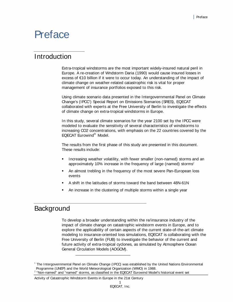
Extra-tropical windstorms are the most important widely-insured natural peril in Europe. A re-creation of Wndstorm Daria (1990) would cause insured losses in excess of €10 billion if it were to occur today. An understanding of the impact of climate change on weather-related catastrophic risk is vital for proper management of insurance portfolios exposed to this risk.
Using climate scenario data presented in the Intergovernmental Panel on Climate Change’s (IPCC1) Special Report on Emissions Scenarios (SRES), EQECAT collaborated with experts at the Free University of Berlin to investigate the effects of climate change on extra-tropical windstorms in Europe.
In this study, several climate scenarios for the year 2100 set by the IPCC were modeled to evaluate the sensitivity of several characteristics of windstorms to increasing CO2 concentrations, with emphasis on the 22 countries covered by the EQECAT Eurowind® Model.
The results from the first phase of this study are presented in this document. These results include:
Increasing weather volatility, with fewer smaller (non-named) storms and an approximately 10% increase in the frequency of large (named) storms2
An almost trebling in the frequency of the most severe Pan-European loss events
A shift in the latitudes of storms toward the band between 48N-61N
An increase in the clustering of multiple storms within a single year
Background
To develop a broader understanding within the re/insurance industry of the impact of climate change on catastrophic windstorm events in Europe, and to explore the applicability of certain aspects of the current state-of-the-art climate modeling to insurance-oriented loss simulations, EQECAT is collaborating with the Free University of Berlin (FUB) to investigate the behavior of the current and future activity of extra-tropical cyclones, as simulated by Atmosphere Ocean General Circulation Models (AOGCM).
1 The Intergovernmental Panel on Climate Change (IPCC) was established by the United Nations Environmental Programme (UNEP) and the World Meteorological Organization (WMO) in 1988.
2 “Non-named” and “named” storms, as classified in the EQECAT Eurowind Model’s historical event set
| Preface
Activity of Catastrophic Windstorm Events in Europe in the 21st Century 2 EQECAT, Inc.
This work is a continuation of past collaborative work with the FUB, which led to the development of EQECAT’s hybrid hazard methodology incorporated in the EQECAT Eurowind Model. Furthermore, this multi-year collaboration is a precursor of an upcoming investigation aimed at low-mode, near-term oscillations of climate and their significance for insurance-loss oriented modeling.
This study focuses on the anthropogenic climate change aspect and investigates the activity of extra-tropical cyclones over Europe during the 20th and 21st
centuries, as modeled by AOGCMs. The run for the 20th century is driven by the actual observed anthropogenic gas concentrations, whereas the 21st century investigation is based on several runs using SRES scenarios prepared by the IPCC (IPCC, 2007).
Findings of existing research studies show that the cyclone activity is driven by the natural variability of the current climate and that, in a longer term, it is a function of the signal of anthropogenic climate change, superimposed on these natural climatic cycles.
This document presents the results of a first stage of this project, which involves multiple models, runs, and scenarios. In this first stage, one model (ECHAM5/OM1) was used to perform several runs to capture gas concentrations during the 20th century, as well as two different future CO2 concentration scenarios (SRES scenarios A1B and A2).
To allow for a more comprehensive interpretation of results, wherever possible, the analysis of modeled storms is put into the perspective of historical events, which are well-known within the insurance industry. Consequently, some modeled results are put into the perspective of Windstorm Daria and a group of the 90 most severe storms that have occurred over Europe during the last 50 years. These storms include all named storms in EQECAT’s Eurowind Model historical event set.
| Latest Scientific Findings
Activity of Catastrophic Windstorm Events in Europe in the 21st Century 3 EQECAT, Inc.
Latest Scientific Findings While regional simulations of the future activity of extra-tropical cyclones show a relative large spread of results due to several factors, such as the physics of various AOGCMs, model resolution, the climate change scenario or the storm tracking algorithm used, the latest findings from AOGCM simulations indicate two major trends:
a decrease in the total number of extra-tropical cyclones
an increase in the number of severe cyclones
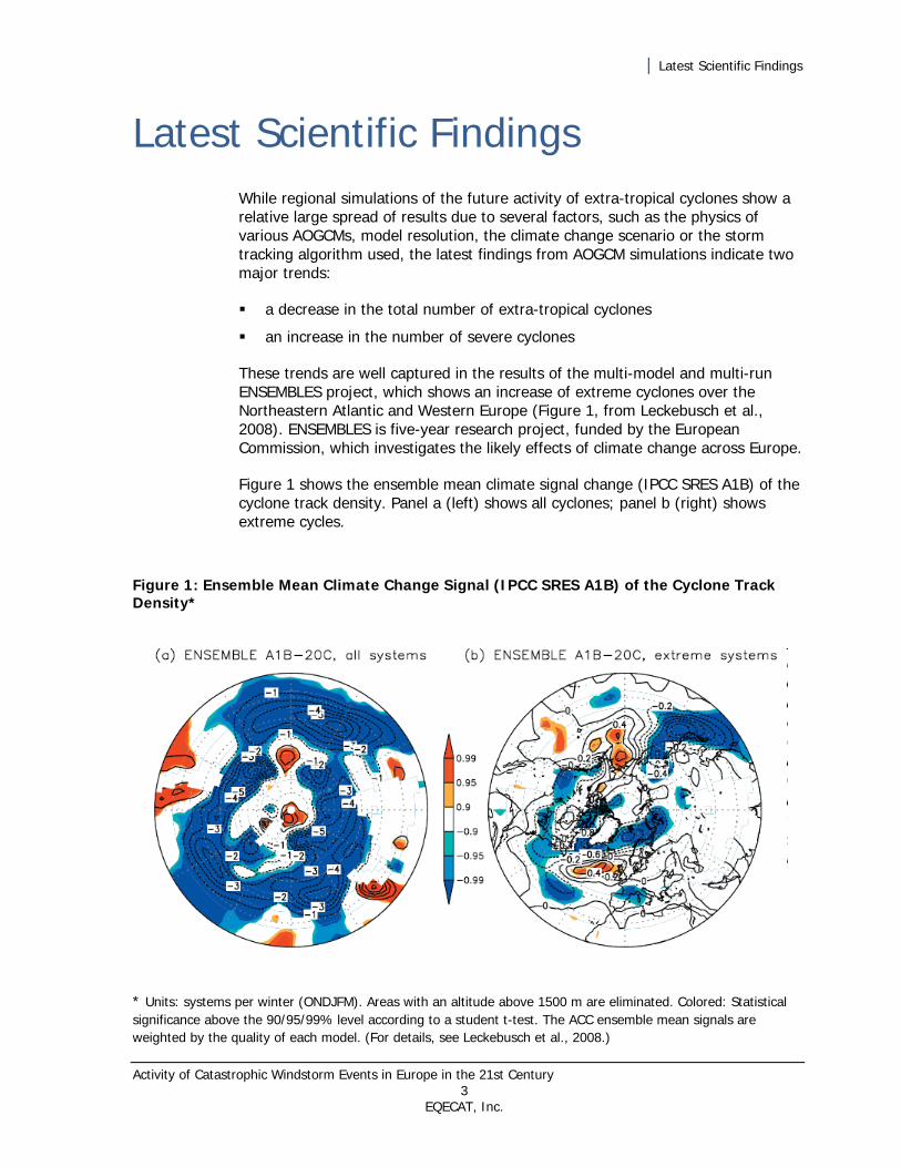
These trends are well captured in the results of the multi-model and multi-run ENSEMBLES project, which shows an increase of extreme cyclones over the Northeastern Atlantic and Western Europe (Figure 1, from Leckebusch et al., 2008). ENSEMBLES is five-year research project, funded by the European Commission, which investigates the likely effects of climate change across Europe.
Figure 1 shows the ensemble mean climate signal change (IPCC SRES A1B) of the cyclone track density. Panel a (left) shows all cyclones; panel b (right) shows extreme cycles.
Figure 1: Ensemble Mean Climate Change Signal (IPCC SRES A1B) of the Cyclone Track Density*
* Units: systems per winter (ONDJFM). Areas with an altitude above 1500 m are eliminated. Colored: Statistical significance above the 90/95/99% level according to a student t-test. The ACC ensemble mean signals are weighted by the quality of each model. (For details, see Leckebusch et al., 2008.)

| Latest Scientific Findings
Activity of Catastrophic Windstorm Events in Europe in the 21st Century 4 EQECAT, Inc.
The results and trends of the EQECAT/FUB study are in agreement with the findings of earlier academic studies. The added value to this area of research comes from EQECAT’s catastrophe modeling expertise and its analyses of storm parameters and features, for example, storm severity indices or storm clustering, which are of special relevance to the estimation of insurance losses,
| Scope of the Study
Activity of Catastrophic Windstorm Events in Europe in the 21st Century 5 EQECAT, Inc.
Scope of the Study Our study is based on several AOGCM runs for two different 100-year greenhouse gas forcing periods (1901-2000 and 2001-2100) and a comparative analysis of the modeled output with regard to changes in values of the following parameters:
storm severity index
storm wind speed
storm area
storm duration
storm location
value of the North Atlantic Oscillation Index
degree of temporal clustering of storms
The first five parameters provide information regarding the damage potential and thus, the impact, of individual storms. The last two parameters are important in terms of annual loss aggregates. For the purposes of presenting the results of this study in a context relevant to loss modeling, these parameters can be grouped into the following three categories:
frequency of severe events
characteristics of severe events
location of severe events
Impact and general storm activity have been evaluated for countries covered by EQECAT’s Eurowind Model, as shown in Figure 2.
Wherever possible, the modeled results are described from the perspective of historical observational storm data. Normalization of both data sets, which is the basis of the Eurowind Model’s “hybrid hazard” approach, allows for such a comparison.
Analysis of 100-year periods has been given preference over comparisons of 30-year segments, which are typically used in IPCC-type of investigations. This is to better account for the full scope of climatic oscillations, whose development in time tends to vary in the differently initiated runs and which may not necessarily be fully captured in the last 30 years of the respective centuries.
The AOGCM used in this part of the study is the ECHAM5/OM1 model from the Max Planck Institute of Meteorology with a resolution of 1.8 degrees and 6-hourly result output.
The emission scenarios used are those of CO2 levels measured during the 1901-2000 period run (called the “present day reference run”, referred to hereafter in this document as “control run”) and the SRES scenarios A1B and A2 for the 2001-
| Scope of the Study
Activity of Catastrophic Windstorm Events in Europe in the 21st Century 6 EQECAT, Inc.
2100 simulations. One control run, three differently initiated A1B scenario runs (hereafter referred to in this document as “A1B_1”, “A1B_2”, and “A1B_3”) and one A2 run have been evaluated so far. The single control run is backed up by statistics from two other control runs (not analyzed or shown here), which indicate a mean inter-run variability of the mean number of events of approximately 3% and a mean inter-run variability of the standard deviation of the number of events of approximately 11%.
Impacts of two different SRES scenarios, namely those of A1B and A2, have been investigated. The A1B scenario assumes an increase of CO2 concentrations up to the middle of the 21st century and a gradual leveling off afterward, while the A2 scenario uses a continuously increasing level of concentrations throughout the entire 21st century (IPCC, 2007)
A storm tracking algorithm developed by Leckebusch et al. (2008) using the 98th percentile value of the local wind speed as a threshold has been applied to the 10-meter wind speed field of the ensemble of AOGCM model simulation. The cyclones responsible for the storms are identified by applying a modified Murray and Simmonds cyclone tracking algorithm (Murray and Simmonds, 1991) to the mean sea level pressure field and extracting the storm causing cyclones. This filter yields modeled storms, which are approximately equivalent to real storm events with wind speeds of approximately 20 meters per second over Germany (Klawa and Ulbrich, 2003).
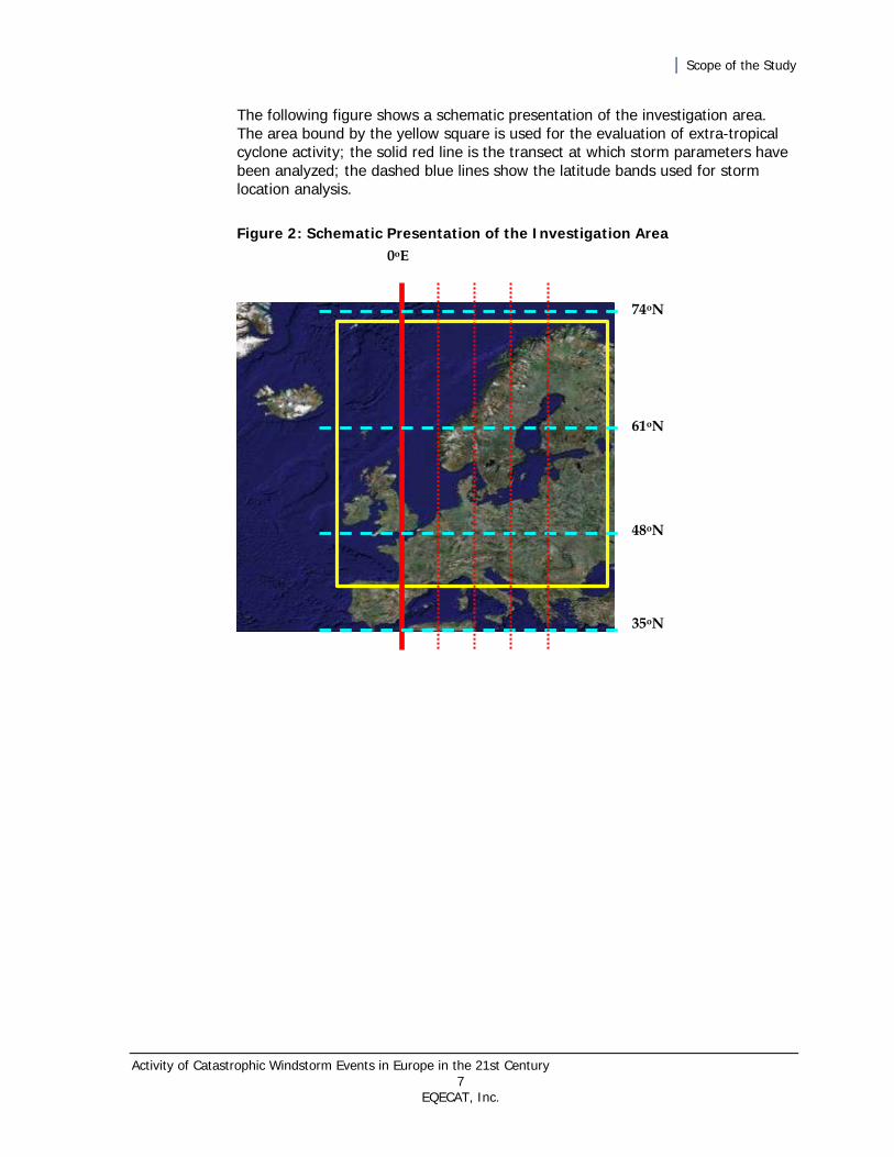
The storm characteristics are evaluated at five different meridional European transects spread evenly across the longitudes of 0oE to 20oE (Figure 2). Twenty- five different parameters (such as storm severity, wind speed, area, duration, atmospheric pressure, etc.) have been calculated for each transect. The seven most important ones (listed at the beginning in this section) extracted at the Greenwich meridian have so far been analyzed.
Furthermore, the storm tracks have been analyzed with regard to their location using three latitudinal bands of equal width (Figure 2). Although the accuracy of AOGCM results is known to generally decrease on regional levels, this is believed to be partially offset by the use of the ECHAM5/OM1 model and the storm tracking method, especially calibrated for the European region.
All results are presented in the form of ratios relative to the control run (1901-2000) simulation.
Results based on one AOGCM and several scenario runs cannot capture the full spectrum of uncertainties associated with climate change simulations. Consequently, the intermediate results, presented here, must be seen as one possible, although reasonably likely, climate change outcome (ECHAM5 results lie in the middle of all ENSEMBLES simulations). In this respect we chose to take a pragmatic approach to this issue and provide the most up-to-date results from one of the most respected state-of-the-art atmospheric models and scientific knowledge currently available. This is accompanied by a continuous monitoring of the newest research developments and refinement or updating of our results once the newest findings warrant it.
| Scope of the Study
Activity of Catastrophic Windstorm Events in Europe in the 21st Century 7 EQECAT, Inc.
The following figure shows a schematic presentation of the investigation area. The area bound by the yellow square is used for the evaluation of extra-tropical cyclone activity; the solid red line is the transect at which storm parameters have been analyzed; the dashed blue lines show the latitude bands used for storm location analysis.
Figure 2: Schematic Presentation of the Investigation Area
0oE
74oN
61oN
48oN
35oN

| Changes in Frequency of Severe Events
Activity of Catastrophic Windstorm Events in Europe in the 21st Century 8 EQECAT, Inc.
Changes in Frequency of Severe Events
This section provides a comparative analysis of the modeled output with regard to changes in the frequency of severe events.
Storm Severity Index
Background Information
Meteorological severity of a storm is a strong indicator of its loss potential. The two parameters show a very strong correlation over densely populated areas. Meteorological severity is best described in terms of the storm severity index (SSI).
In the first part of this study we investigate the differences between the SSIs of storms of the control run (1901-2000) with those from the climate change driven simulations for the 21st century. To allow for an easier interpretation of the changes in storm damage potential, the differences are explained in terms of the severity of selected real historical storms, which the insurance sector tends to be familiar with.
The SSI it is expressed as the sum of cubed wind speeds (above a certain threshold) integrated over the area and duration of the storm. Only wind speeds over land grid points are considered. The SSIs have been calculated for all modeled storms generated in the respective 100-year runs. They have also been compiled for all observed storms in the EQECAT Eurowind Model’s set of historical events.
The analysis has been performed for four separate groups of storm severity covering different SSI ranges. They are labeled “all,” “unnamed,” “named,” and “Daria-strength-like” storms, respectively (Figure 3).
The labels of the four storm groups are related to the nomenclature used in EQECAT’s Eurowind Model. The category of “named storms,” for example, gets its name from the SSI range roughly covered by the 90 most severe events in the Eurowind Model’s event set of 355 historical storms. Among these 90 storms are many events that have caused substantial damage and are well-known to the insurance sector by name. To facilitate their identification within EQECAT’s data set, their identification code also includes the storm name. The modeled equivalents of these storms are thus to be seen as having a similar damage potential as their historical counterparts. The historical “named” storms have typically caused economic damage of at least several hundred million euros. Anna (2002) or Jan (2003) can be seen as typical reference examples located close to
| Changes in Frequency of Severe Events
Activity of Catastrophic Windstorm Events in Europe in the 21st Century 9 EQECAT, Inc.
the lower SSI bounds of this storm group. The upper bounds of this group are demarcated by Vivian (1990).
All storms that reach at least the meteorological severity of Daria are also analyzed separately. The results of this analysis are summarized in the group of “Daria-strength-like” storms.
Finally, the group of “unnamed” storms comprises modeled events, which typically correspond to historical storms that have caused economic losses smaller than several hundred million euros.
The SSI thresholds used for demarcation of individual groups are based on normalized SSI values of selected historical storms, such as Daria.
It must be noted that the link between the observed and modeled storms cannot be made in terms of the dates of occurrence, as the AOGCM control run (with the exception of observed concentrations of anthropogenic gases and radiative forcing) has been driven by climatological and not real meteorological conditions. The AOGCM can successfully generate Daria-like, or Wiebke-like systems in terms of their severity and frequency, but it does not reproduce Windstorm Daria exactly as it occurred on January 25, 1990, or Windstorm Wiebke, which followed on February 28, 1990.
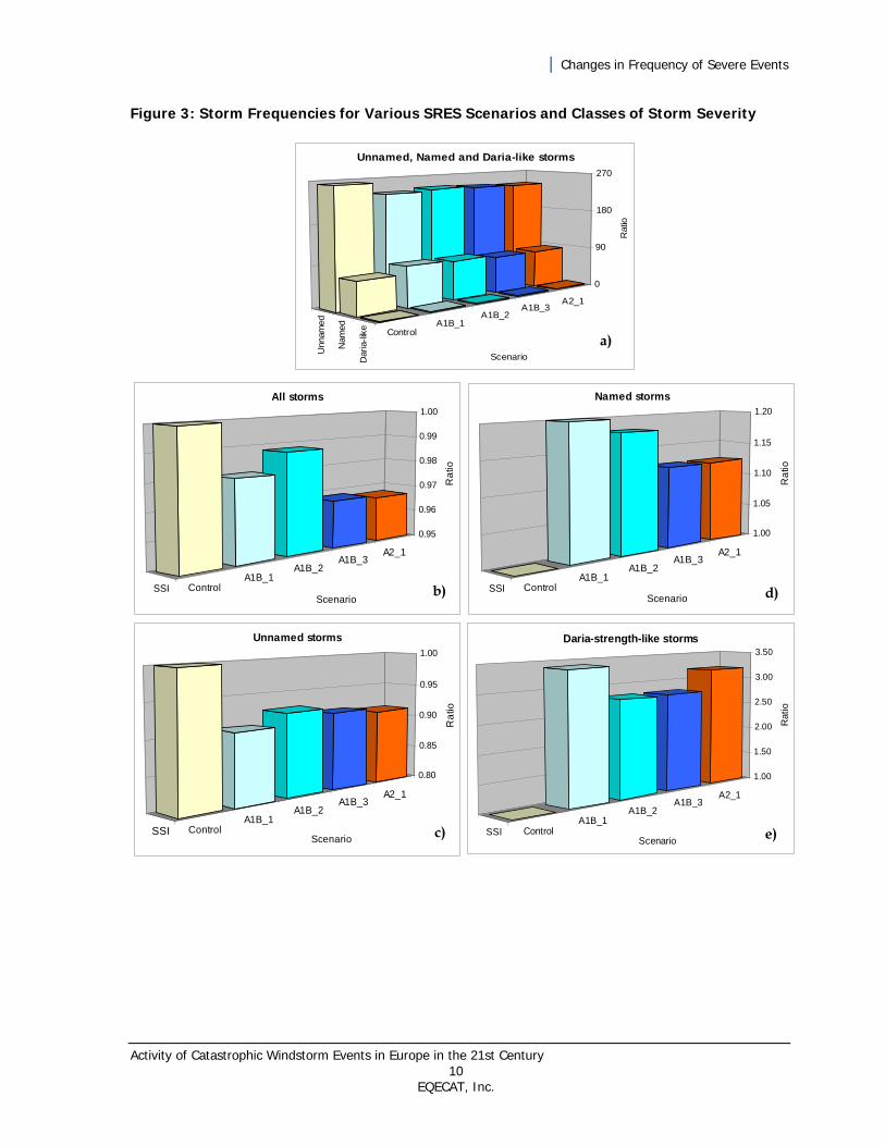
Figure 3 shows storm frequencies for various SRES scenarios and classes of storm severity in terms of SSI expressed as the ratio to the number of storms in the 1901-2000 control run (that is, the present day reference run). Panel a in the figure shows the three different groups of storm severity and the ratios of their frequencies relative to the value of the “Daria-strength-like” category of the control run. Panel b shows “all” modeled storms. Panels c, d, and e show modeled equivalents of “unnamed” storms within the Eurowind Model’s historical event set, “named” storms within the Eurowind Model’s historical event set, and “Daria-strength-like” or stronger storms, respectively.
| Changes in Frequency of Severe Events
Activity of Catastrophic Windstorm Events in Europe in the 21st Century 10 EQECAT, Inc.
Figure 3: Storm Frequencies for Various SRES Scenarios and Classes of Storm Severity
SSI ControlA1B_1
A1B_2A1B_3
A2_1
1.00
1.50
2.00
2.50
3.00
3.50
Rat
io
Scenario
Daria-strength-like storms
SSI ControlA1B_1
A1B_2A1B_3
A2_1
0.95
0.96
0.97
0.98
0.99
1.00
Ra
tio
Scenario
All storms
SSI ControlA1B_1
A1B_2A1B_3
A2_1
0.80
0.85
0.90
0.95
1.00
Ra
tio
Scenario
Unnamed storms
SSI ControlA1B_1
A1B_2A1B_3
A2_1
1.00
1.05
1.10
1.15
1.20
Ra
tio
Scenario
Named storms
Unn
amed
Nam
ed
Dar
ia-li
ke ControlA1B_1
A1B_2A1B_3
A2_1
0
90
180
270
Rat
io
Scenario
Unnamed, Named and Daria-like storms
a)
b) d)
c) e)
| Changes in Frequency of Severe Events
Activity of Catastrophic Windstorm Events in Europe in the 21st Century 11 EQECAT, Inc.
Findings
Regardless of the SRES scenario, the distributions of the three storm severity groups are highly skewed toward the weaker (but still important) events, or the “unnamed” storms. Storms in this category are three to four times more frequent than the “named” storms. In comparison, “Daria-severity-like” or stronger events account for less than 1% of all modeled events (Figure 3a).
When analyzed from the perspective of the total number of storms, all SRES scenarios show a clear decrease of about 3% in the number of storms compared to the control run (present day reference run). This decrease in total number of storms is somewhat stronger in the A2 than in the A1B scenarios (Figure 3b).
When analyzed separately, the “unnamed” storms (the group with a lower damage potential) show a decrease of around 10% in all SRES scenarios, compared to the control run numbers (Figure 3c).
This trend is reversed in the analysis of the “named” storms group (those storms that have a substantial catastrophic potential). The respective SRES scenarios show an increase of between 10% (A2 scenario) and 20% (A1B scenario runs) in the number of storms of this severity (Figure 3d).
The increase in the number of storms in the SRES scenarios becomes even more pronounced when the extreme, “Daria-severity-like” or stronger systems are investigated. As shown in Figure 3e, all SRES scenarios show a two- to three-fold increase in the number of extreme storms over the next century.
Cyclical Influence/Value of the North Atlantic Oscillation Index
Background Information
The interplay between the strength of a core of atmospheric high pressure over the Azores and a core of atmospheric low pressure over Iceland is described as the North Atlantic Oscillation (NAO). It is expressed in terms of the North Atlantic Oscillation Index, which describes the degree of the pressure gradient anomaly between these two poles. The magnitude of this pressure gradient anomaly is often seen as one of the steering factors of storm activity in the North Atlantic-West European region.
Enhanced storm development has often been observed during positive phases of the NAO (Pinto et al., 2009). For example, some the most severe historical storms, like Daria (NAO: 1.04), Vivian (NAO: 1.41), or Lothar and Martin (NAO: 1.61) have developed during periods of positive (monthly) NAO values.
Bearing this relationship between storm development and the various phases of NAO in mind, we have analyzed future storm frequencies with regard to the
| Changes in Frequency of Severe Events
Activity of Catastrophic Windstorm Events in Europe in the 21st Century 12 EQECAT, Inc.
corresponding values of the monthly NAO Index. The NAO indices have been subdivided into four categories named “highly negative NAO,” “moderately negative NAO,” “moderately positive NAO,” and “highly positive NAO.” They are delineated by the following NAO values: -5.0 to -1.5, -1.5 to 0, 0 to +1.5 and +1.5 to +5.0.
Findings
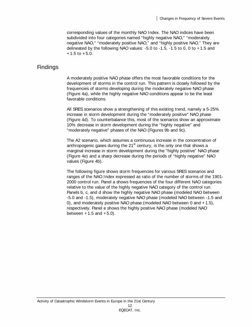
A moderately positive NAO phase offers the most favorable conditions for the development of storms in the control run. This pattern is closely followed by the frequencies of storms developing during the moderately negative NAO phase (Figure 4a), while the highly negative NAO conditions appear to be the least favorable conditions.
All SRES scenarios show a strengthening of this existing trend, namely a 5-25% increase in storm development during the “moderately positive” NAO phase (Figure 4d). To counterbalance this, most of the scenarios show an approximate 10% decrease in storm development during the “highly negative” and “moderately negative” phases of the NAO (Figures 9b and 9c).
The A2 scenario, which assumes a continuous increase in the concentration of anthropogenic gases during the 21st century, is the only one that shows a marginal increase in storm development during the “highly positive” NAO phase (Figure 4e) and a sharp decrease during the periods of “highly negative” NAO values (Figure 4b).
The following figure shows storm frequencies for various SRES scenarios and ranges of the NAO Index expressed as ratio of the number of storms of the 1901-2000 control run. Panel a shows frequencies of the four different NAO categories relative to the value of the highly negative NAO category of the control run. Panels b, c, and d show the highly negative NAO phase (modeled NAO between -5.0 and -1.5), moderately negative NAO phase (modeled NAO between -1.5 and 0), and moderately positive NAO phase (modeled NAO between 0 and +1.5), respectively. Panel e shows the highly positive NAO phase (modeled NAO between +1.5 and +5.0).
| Changes in Frequency of Severe Events
Activity of Catastrophic Windstorm Events in Europe in the 21st Century 13 EQECAT, Inc.
Figure 4: Storm Frequencies for Various SRES Scenarios and Ranges of the North Atlantic Oscillation Index
NAO ControlA1B_1
A1B_2A1B_3
A2_1
0.85
0.90
0.95
1.00
1.05
Ra
tio
Scenario
Highly negative NAO
NAO ControlA1B_1
A1B_2A1B_3
A2_1
0.70
0.80
0.90
1.00
Ra
tio
Scenario
Moderately negative NAO
NAO ControlA1B_1
A1B_2A1B_3
A2_1
1.00
1.05
1.10
1.15
1.20
1.25
Ra
tio
Scenario
Moderately positive NAO
NAO ControlA1B_1
A1B_2A1B_3
A2_1
0.85
0.90
0.95
1.00
1.05
Ra
tio
Scenario
Highly positive NAO
b)
c)
d)
e)
-5 to
-1.
5
-1.5
to 0
0 to
+1.
5
1.5
to +
5 ControlA1B_1
A1B_2A1B_3
A2_1
0.851.001.151.301.451.601.751.902.05
Ra
tio
Scenario
All four NAO bands
a)
| Changes in Frequency of Severe Events
Activity of Catastrophic Windstorm Events in Europe in the 21st Century 14 EQECAT, Inc.
Storm Clustering
Background Information
The 1990 storm season, with a sequence of six severe storms affecting Europe in a six-week span, has, for the first time, drawn the attention of insurers to the phenomenon of storm clustering. Having a strong influence on the annual loss aggregates, this phenomenon has been investigated in several studies since then (for example, Vitolo et al., 2009)
In this analysis we have first compared the clustering characteristics of the AOGCM control run (1901-2000) with the frequency of storm clustering, as observed during the last 49 years.
Subsequently, the storm clustering of the control run has been compared with clustering frequencies generated by the individual SRES scenarios. The focus here has been on changes in frequency of clusters with three severe storms per year, as observed, for example, during the 1999 winter season. The analysis has been based on the 90 most severe (or “named”) storms and their equivalents only.
In parallel to that, we have also analyzed the changes in selected SSI sums, namely those corresponding to the severity of three Darias occurring within one year, as well as the total 100-year SSI sums for the individual SRES scenarios. This part of the study was based on all modeled storms.
Findings
The results of the control run simulation of clusters of three severe storms per season are in reasonably good agreement with the observational data for the past 49 years. The model generates approximately twice as many three-storm clusters per century, as shown in the historical data for the past 49 years (Figure 5a). The comparison of five- to seven-storm clusters yields more noisy results with somewhat higher frequency of observed five-storm clusters (during the last 49 years) counterbalanced by the occurrence of a not yet observed seven-event cluster in the 100-year long modeled data.
Control run simulation of five severe storms per season yields approximately three clusters per century. In contrast to that, the SRES scenarios show a two- to threefold increase in the occurrence of these phenomena (Figure 5b).
Similarly, the SRES scenarios also show a two- to four-fold increase in the frequency of annual SSI sums equaling to the strength of three Darias occurring within one and the same year (Figure 5c). One A1B scenario even generates one year in which the annual SSI sum equals to the strength of four Darias (regardless of the number of storms, which contributes to this SSI sum).

| Changes in Frequency of Severe Events
Activity of Catastrophic Windstorm Events in Europe in the 21st Century 15 EQECAT, Inc.
Finally, a similar pattern can also be depicted in the comparison of the 100-year SSI sums for the five individual runs. Despite overall lower numbers of all extra-tropical storms over Europe, all SRES scenarios runs show an increase (of approximately 50 percent) in the 100-year SSI sums (Figure 5d).
In the following figure, panel a shows frequencies of observed and modeled storm clusters of three or more named storms per year (observations [labeled as History] based on the 1960-2008 period; modeled [labeled as AOGCM] on the 1901-2000 reference control run). Panel b shows frequencies of storm clusters with various numbers of storms per year for the control run and various SRES scenarios. Panel c shows storm frequencies for various SRES scenarios and SSI sum equivalents of three and four Darias per year (expressed as ratio of the 1901-2000 control run). Panel d shows 100-year SSI sums for various SRES scenarios (expressed as ratio of the SSI sum of the 1901-2000 control run).
Figure 5: Frequencies of Observed and Modeled Storm Clusters and Various SSI Sums
3 4 5 67
89
10
AOGCM (100y)
History (49y)
0
5
10
15
20
Fre
quency
Number storms / year
Frequency of clustering (3+ Named storms per year)
3 4 5 6 7 8 910 Control
A1B_1A1B_2
A1B_3A2_1
0
5
10
15
20
Fre
quen
cy
Storms / yearScenario
Frequency of clustering (3+ named storms per year)
SSI ControlA1B_1
A1B_2A1B_3
A2_1
1.00
1.25
1.50
1.75
Ra
tio
Scenario
100 year SSI sum
3 4 ControlA1B_1
A1B_2A1B_3 A2_1
0
1
2
3
4
Rat
io
Darias Scenario
Frequency of the annual SSI equivalent of 3 and 4 Darias per year
a)
b)
c)
d)

| Changes in Characteristics of Severe Events
Activity of Catastrophic Windstorm Events in Europe in the 21st Century 16 EQECAT, Inc.
Changes in Characteristics of Severe Events
This section provides a comparative analysis of the modeled output with regard to the characteristics of severe events—maximum wind speed, storm area and duration, of storms. All of these factors are strong contributors to damage and insured loss.
Maximum Wind Speed
Background Information
Changes in maximum wind speed are important for insurance-oriented loss modeling as they entail exponential changes to losses.
In this part of the study we investigate the maximum wind speeds over land of all storms, generated in the five individual ECHAM5/OM1 runs. The analysis pertains to those storms whose tracks cross the Greenwich meridian only between 41oN and 71oN.
AOGCM generated storm wind speeds tend to be systematically lower than observed wind speeds. This is partially due to the varying resolution of AOGCMs and calculation of atmospheric conditions at specific model grid points. In such a mesh of grid points it is not always possible to represent certain aspects of the topography or the entire continuum of atmospheric processes. This makes a direct comparison between the two types of variables difficult. For this reason, no direct inter-comparison with wind speeds of historical events has been attempted.
The analysis is performed for three different wind speed ranges, hereafter referred to as “low-range,” “medium-range,” and “high-range” wind speeds. The ranges correspond to three adjacent, equally-wide, wind speed bins that together cover the entire range of modeled maximum storm wind speeds. The group of “high-range” wind speeds corresponds approximately to the upper 10% of all modeled wind speeds.
Findings
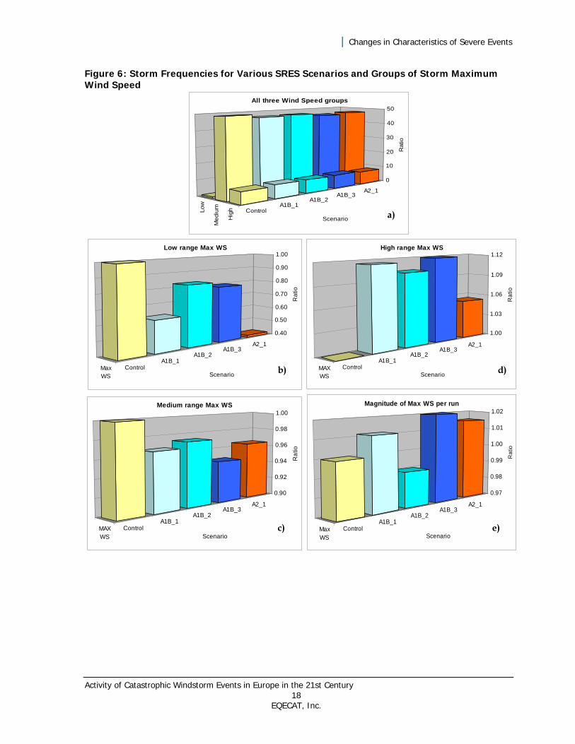
About 80% of all tracked storms can be found in the “medium-range” wind speed category and approximately 15% in the “high-range” wind speed values. This distribution is a function of the storm tracking algorithm threshold, which has been chosen in such a way as to eliminate all weaker systems (Figure 6a).

| Changes in Characteristics of Severe Events
Activity of Catastrophic Windstorm Events in Europe in the 21st Century 17 EQECAT, Inc.
Compared to the control run, all SRES scenarios display a decrease in the number of storms in the “low-range“ and “medium-range” wind speed categories and an increase in the “high-range” wind speed group. The decrease is especially pronounced in the “low-range” category, ranging from 20% to 60% (Figure 6b). It is only marginal in the “medium-range” group (Figure 6c). In contrast to that, the SRES scenarios show approximately 10% more storms in the “high-range” wind speed category than the control run (Figure 6d).
The comparison of the overall maximum wind speed of the individual century runs (one value, which can be more prone to randomness than the entire distribution of results), does not show any significant differences between the control run and the SRES scenario simulations (Figure 6e).
Figure 6 shows the storm frequencies for various SRES scenarios and groups of storm maximum wind speed expressed as ratio of the number of storms of the 1901-2000 control run (present day reference run), Panel a shows three groups of storms with different maximum wind speeds and the ratios of their frequencies relative to the value of the “low-range” wind speed category of the control run. Panels b, c, and d show groups of storms with “low-range,” “medium-range,” and “high-range” maximum wind speeds, respectively. Panel e shows the ratios pertaining to overall maximum wind speed.
| Changes in Characteristics of Severe Events
Activity of Catastrophic Windstorm Events in Europe in the 21st Century 18 EQECAT, Inc.
Figure 6: Storm Frequencies for Various SRES Scenarios and Groups of Storm Maximum Wind Speed
MaxWS
ControlA1B_1
A1B_2A1B_3
A2_1
0.97
0.98
0.99
1.00
1.01
1.02
Rat
io
Scenario
Magnitude of Max WS per run
MaxWS
ControlA1B_1
A1B_2A1B_3
A2_1
0.40
0.50
0.60
0.70
0.80
0.90
1.00
Ra
tio
Scenario
Low range Max WS
MAXWS
ControlA1B_1
A1B_2A1B_3
A2_1
0.90
0.92
0.94
0.96
0.98
1.00
Ra
tio
Scenario
Medium range Max WS
MAXWS
ControlA1B_1
A1B_2A1B_3
A2_1
1.00
1.03
1.06
1.09
1.12
Ra
tio
Scenario
High range Max WS
b)
c)
d)
e)
Low
Mediu
m
Hig
h ControlA1B_1
A1B_2A1B_3
A2_1
0
10
20
30
40
50
Ratio
Scenario
All three Wind Speed groups
a)

| Changes in Characteristics of Severe Events
Activity of Catastrophic Windstorm Events in Europe in the 21st Century 19 EQECAT, Inc.
Storm Area
Background Information
The spatial extent of storms is of special importance for market portfolios spanning several countries. Changes in storm area and changes in losses tend to show a linear relationship.
In this study the modeled storm area is calculated through an integration of the area of all grid boxes having a storm severity over a certain threshold during the life span of the system. Thus, it is a function of the resolution of the ECHAM5/OM1 model grid point mesh and the threshold value used by the storm tracking algorithm.
Similar to the treatment of modeled wind speeds, the areas of the individual storms have not been normalized. Thus, in contrast to the inter-comparison of observed and modeled storm severity indices, a direct comparison with the areas of historical storms is not attempted here.
The comparison has been performed for three different storm groups, hereafter referred to as “smaller–size,” “medium–size,” and “large-size” storms. The “smaller-size” storm typically span over one to three countries, whereas the “large-size” storms affect at least half the 22 countries covered by EQECAT’s Eurowind Model. The delineation of the groups is based on an a priori segregation of two large outlier values and subdivision of the remaining range of modeled storm areas over land into equally-spaced bins (the two outlier values are counted as belonging to the category of large size storms).
Findings
The distribution of all storms categorized according to their area is strongly skewed toward the group of “smaller-size” storms so that a very large proportion of all events can be found in this category (Figure 7a). The extremely large storms are roughly 100 times less frequent than the “smaller-size” storms.
All SRES scenarios for the smaller size storm category show only a small (up to 7%) decrease in the respective storm numbers, compared with the control run (Figure 7b).
The trend is reversed in the category of “medium-size” storms, where the SRES scenarios show a 20-40% larger number of respective events than the control run (Figure 7c).
Analysis of the group of “large-size” storms displays a similar trend with a majority of SRES scenarios showing a larger number of storms than the control run. The slightly lower A1B_2 result is likely to be due to randomness associated with the small sample of storms in this category (Figure 7d).
| Changes in Characteristics of Severe Events
Activity of Catastrophic Windstorm Events in Europe in the 21st Century 20 EQECAT, Inc.
Comparison of the absolute storm area maxima generated by the individual SRES scenarios displays a more uniform pattern with similar maximum magnitudes. An exception to that is the A1B_1 run, which contains one of the outlier values.
Figure 7 shows storm frequencies for various SRES scenarios and classes of storm area expressed as a ratio of the number of similarly-sized storms of the 1901-2000 control run. Panel a compares all three classes of storm areas and the ratios of their frequencies relative to the value of the “large-size” storm category of the control run. Panels b, c, and d show the results for “smaller-size,” “medium-size,” and “large-size” storms, respectively. Panel e shows the ratios pertaining to the overall maximum storm area per run.

| Changes in Characteristics of Severe Events
Activity of Catastrophic Windstorm Events in Europe in the 21st Century 21 EQECAT, Inc.
Figure 7: Storm Frequencies for Various SRES Scenarios and Classes of Storm Area
Small
MediumLarge Control
A1B_1A1B_2
A1B_3A2_1
-
30
60
90
120
150
Rat
io
Scenario
All three Storm Size groups
a)
Area ControlA1B_1
A1B_2A1B_3
A2_1
0.75
1.00
1.25
1.50
Rat
io
Scenario
Large size storms
Area ControlA1B_1
A1B_2A1B_3
A2_1
1.00
1.10
1.20
1.30
1.40
1.50
Rat
io
Scenario
Medium size storms
Area ControlA1B_1
A1B_2A1B_3
A2_1
0.90
0.92
0.94
0.96
0.98
1.00
Rat
io
Scenario
Smaller size storms
MaxArea
ControlA1B_1
A1B_2A1B_3
A2_1
0.90
1.00
1.10
1.20
1.30
1.40
Ra
tio
Scenario
Maximum Storm Area per run
b)
c)
d)
e)
| Changes in Characteristics of Severe Events
Activity of Catastrophic Windstorm Events in Europe in the 21st Century 22 EQECAT, Inc.
Storm Duration
Background Information
The changes in storm duration and changes in storm losses tend to be linked through a linear relationship. Definitions of storm duration within the industry do vary, but some modeling studies indicate that prolonged storm duration can add up to 20% to the final storm losses.
In this study the storm duration is derived from the number of six-hourly time steps at which the storm tracking algorithm detects a storm over any land grid point within the modeled area. For the purpose of this study, the duration of individual modeled storms has not been normalized and therefore is not directly comparable with the data of observed historical storms.
In parallel to the analysis of other parameters, the entire range of modeled storm durations has been subdivided into three equally-long time period bins. Hereafter, they are referred to as “short-duration,” “medium-duration,” and “long-duration” storms. These categories correspond to storm life spans of up to two model days, up to four model days, and up to six model days, respectively.
Findings
Regardless of the scenario, “short-duration” storms tend to be three times more frequent than “medium-duration” events, and about 100 times more frequent than “long-duration” events (Figure 8a).
The SRES scenario results for the “short-duration” category and those for the “medium-duration” category show only small differences in the number of respective storms. In the case of the “short-duration” group, the SRES results are consistently lower than those of the control run (Figure 8b), while they consistently yield higher numbers in the analysis of “medium-duration” storms (Figure 8c).
The real differences can be found in the category of “long-duration” storms, in which the SRES scenarios yield 30-100% higher storm numbers than the control run (Figure 8d). This trend is confirmed by the comparison of the overall maximum storm duration obtained during the individual 100-year runs. All SRES scenarios generate longer-lasting storms than the maximum storm duration obtained during the control run, even though in the case of the A2 scenario run this difference is only marginal (Figure 8e).
Figure 6 shows storm frequencies for various SRES scenarios and classes of storm duration expressed as ratio of the number of storms of the 1901-2000 reference control run. Panel a shows all three classes of storm duration and the ratios of their frequencies relative to the value of the “long-duration” category of the control run. Panels b, c, and d show “short-duration,” “medium-duration,” and “long–duration” storms, respectively. Panel e shows the ratios pertaining to the overall maximum storm duration per run.

| Changes in Characteristics of Severe Events
Activity of Catastrophic Windstorm Events in Europe in the 21st Century 23 EQECAT, Inc.
Figure 8: Storm Frequencies for Various SRES Scenarios and Classes of Storm Duration
Time ControlA1B_1
A1B_2A1B_3
A2_1
0.90
0.92
0.94
0.96
0.98
1.00
Ra
tio
Scenario
Short Duration Storms
Time ControlA1B_1
A1B_2A1B_3
A2_1
1.00
1.05
1.10
1.15
1.20
1.25
Ra
tio
Scenario
Mamimum Duration per run
Time ControlA1B_1
A1B_2A1B_3
A2_1
1.00
1.02
1.04
1.06
1.08
1.10
Ra
tio
Scenario
Medium Duration Storms
Time ControlA1B_1
A1B_2A1B_3
A2_1
1.00
1.30
1.60
1.90
2.20
Ra
tio
Scenario
Long Duration Storms
b)
c)
d)
e)
Short
Medium
Long ControlA1B_1
A1B_2A1B_3
A2_1
0
30
60
90
120
Ra
tio
Scenario
All three Duration groups
a)

| Changes in Storm Location
Activity of Catastrophic Windstorm Events in Europe in the 21st Century 24 EQECAT, Inc.
Changes in Storm Location This section provides a comparative analysis of the modeled output with regard to changes in storm location.
Storm Location
Background Information
Maximum wind speed, storm area, and storm duration are the driving factors behind the damage potential of a storm. It is, however, the storm track and the risk density beneath that track, which determine the final storm loss. The most damaging storms tend to have a zonal track extending from southern parts of the United Kingdom over the Benelux countries and Northern France to Germany.
The storm track analysis is performed for three different, equally-wide European latitude bands, shown in Figure 2. Thereafter, they are referred to as the “southern latitude,” central latitude,” and “northern latitude” bands. Their boundaries are demarcated by the following latitude circles: 35oN-48oN, 48oN-61oN, and 61oN-74oN, respectively. The underlying data pertains to the latitude of storm tracks of all storms with damage potential over land as recorded at the Greenwich meridian. Storms with zonal tracks crossing the southern parts of the United Kingdom and the Benelux countries, as mentioned above, would fall into the “central latitude” band.
Findings
The distribution of storm tracks is skewed toward higher latitudes. In the control run (present day reference run), the majority of storm tracks are found in the “northern latitude” band, closely followed by the “central latitude” band (Figure 9a). This distribution is partly a function of the selection of the boundaries of the respective bands and the use of the winter half of the year data only, which serves as the basis of this investigation.
Compared to the control run, all SRES scenarios display a shift in storm tracks from the “southern latitude” band to the “central latitude” band of Europe (Figure 9b and Figure 9c). The shift is most pronounced in the A1B_1 run. This shift is also partially observable between the “northern” and “central” bands (Figures 9d and 9c).
| Changes in Storm Location
Activity of Catastrophic Windstorm Events in Europe in the 21st Century 25 EQECAT, Inc.
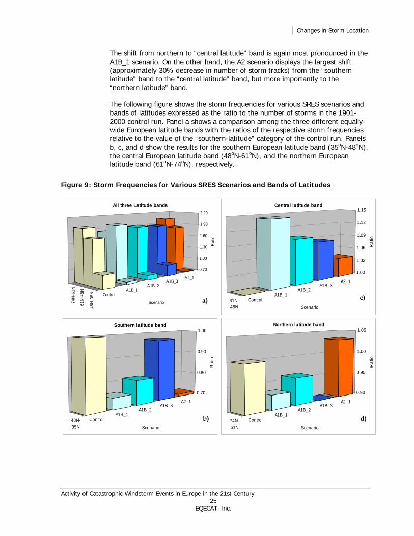
The shift from northern to “central latitude” band is again most pronounced in the A1B_1 scenario. On the other hand, the A2 scenario displays the largest shift (approximately 30% decrease in number of storm tracks) from the “southern latitude” band to the “central latitude” band, but more importantly to the “northern latitude” band.
The following figure shows the storm frequencies for various SRES scenarios and bands of latitudes expressed as the ratio to the number of storms in the 1901-2000 control run. Panel a shows a comparison among the three different equally-wide European latitude bands with the ratios of the respective storm frequencies relative to the value of the “southern-latitude” category of the control run. Panels b, c, and d show the results for the southern European latitude band (35oN-48oN), the central European latitude band (48oN-61oN), and the northern European latitude band (61oN-74oN), respectively.
Figure 9: Storm Frequencies for Various SRES Scenarios and Bands of Latitudes
48N
-35N
61N
-48N
74N
-61N
ControlA1B_1
A1B_2A1B_3
A2_1
0.70
1.00
1.30
1.60
1.90
2.20R
atio
Scenario
All three Latitude bands
a)
48N-35N
ControlA1B_1
A1B_2A1B_3
A2_1
0.70
0.80
0.90
1.00
Ra
tio
Scenario
Southern latitude band
61N-48N
ControlA1B_1
A1B_2A1B_3
A2_1
1.00
1.03
1.06
1.09
1.12
1.15
Ra
tio
Scenario
Central latitude band
74N-61N
ControlA1B_1
A1B_2A1B_3
A2_1
0.90
0.95
1.00
1.05
Ra
tio
Scenario
Northern latitude band
b)
c)
d)
| Summary of Results
Activity of Catastrophic Windstorm Events in Europe in the 21st Century 26 EQECAT, Inc.
Summary of Results This document summarizes the intermediate results of a collaborative study undertaken by EQECAT and the Free University of Berlin. It focuses on possible future changes in severity, frequency, and location of severe extra-tropical storms over Europe, as simulated by various climate change scenarios for the 21st century. The results presented here are based on one AOGCM model (ECHAM5/OM1) and several versions of various SRES scenarios (A1B and A2) only.
The results do not cover the entire spectrum of uncertainties associated with climate change simulations, but have to be interpreted as one possible, although, considering the current state of scientific knowledge, reasonably likely climate change outcome.
The modeled results are presented from the perspective of well-known severe historical storms (such as Daria), which are of importance to the insurance sector. They are investigated in terms of changes to the damage potential of individual storms, as well as from the perspective of annual loss aggregates.
The findings of this investigation are in general agreement with the results of major academic studies. The key findings pertaining to changes in damage potential of individual storms point to the following:
Storm Frequency and Cyclical Influence
a 3-5% decrease in the total number of all potentially damaging storms
a 10% decrease in the number of storms with (current) damage potential of less than several hundred million euros (previously labelled as “unnamed” storms)
a 10-20% increase in the number of storms with a current damage potential of more than several hundred million euros (previously labelled as “named” storms)
a two- to three-fold increase in the frequency of extreme, “Daria-like” severity, or stronger, storms (with a damage potential of more than €10 billion)
for all SRES scenarios, an increase of storm development during moderately positive NAO phases and a decrease in storm development during negative NAO phases
Wind Speed, Storm Area, and Duration
20-60% decreases in the maximum wind speed of weak storms; small (~5%) decreases in the maximum wind speed of “medium-strength storms”; and small (~10%) increases in the maximum wind speed of very strong storms

| Summary of Results
Activity of Catastrophic Windstorm Events in Europe in the 21st Century 27 EQECAT, Inc.
Marginal decreases in the number of “smaller-size” systems, but 20-40% increases in the frequency of “medium-size” and “large-size” events
Marginal changes in the number of storms with short-duration and medium-duration” life span, but an increase of about 50% percent in the number of long-lasting events
Storm Track
A pronounced shift of storm tracks from southern (and somewhat from northern) Europe to central European latitudes (48oN-61oN)
As indicated by the magnitudes of positive correlations between the storm severity index and other major storm parameters (listed in Table 1) increases in the storm damage potential are likely to be driven by increased spatial extent and duration of storms events, rather than by a substantial increase in maximum storm wind speed. Nevertheless, the small increases in wind speeds are still of importance, as wind speed and loss increments tend to show an exponential relationship (as opposed to a more linear relationship between the changes in storm area or storm duration and changes in losses).
The following table shows correlations between the storm severity index and various storm parameters based on SSI values over land of all modeled storms of the A1B_2 run. Highly significant correlation coefficients—those larger than +0.5 and lower than -0.5—are highlighted in orange and blue, respectively. (Note that the correlation coefficients of the other runs differ only marginally from these results).
Table 1: Correlations Between the Storm Severity Index and Various Storm Parameters
SSI
(Lan
d)
Max
. Win
d S
peed
(L
and)
Max
. Win
d S
peed
(O
cean
)
Are
a (L
and)
Du
rati
on
(Lan
d)
Pre
ssu
re
(Lan
d)
NA
O
SSI (Land) -
Max. Wind Speed (Land) 0.48 -
Max. Wind Speed (Ocean) 0.62 0.59 -
Area (Land) 0.75 0.41 -0.14 -
Duration (Land) 0.68 0.52 0.59 0.73 -
Pressure (Land) -0.53 -0.59 -0.56 -0.40 -0.32 -
NAO 0.14 0.23 0.19 0.06 0.06 -0.21 -

| Summary of Results
Activity of Catastrophic Windstorm Events in Europe in the 21st Century 28 EQECAT, Inc.
Storm Clustering and 100-year Storm Severity Sums
Results specific to potential changes in annual loss aggregates and changes in total storm energy are a function of two major factors: the arrival frequencies of storms with severe damage potential and the clustering of storms.
Investigation of the future characteristics of these two features revealed:
A 50-70% increase in the total 100-year storm damage potential in terms of 100-year SSI sums of all storms occurring during one century
A two- to four-fold increase in annual SSI sum equivalents of three Darias occurring within the same year. One A1B scenario even yields one annual SSI sum equivalent of four Darias. In contrast, results of the control run and observational storm data for the past 49 years show only one such scenario
A two- to three-fold increase in the frequency of clusters with five severe storms per season (previously labeled as “named” storms)
| Selected References
Activity of Catastrophic Windstorm Events in Europe in the 21st Century 29 EQECAT, Inc.
Selected References Intergovernmental Panel on Climate Change, 2007: The Emission Scenarios of the IPCC Special
Report on Emission Scenarios (SRES), WMO&UNEP, 2007
Klawa, M. and U. Ulbrich. “A model for the estimation of storm losses and the identification of severe winter storms in Germany.” Natural Hazards and Earth System Sciences 3, no. 6 (2003): 725-732.
Leckebusch, G.C., M. Donat, U. Ulbrich, and J.G. Pinto. “Mid-latitude cyclones and storms in an
ensemble of European AOGCM under ACC.” CLIVAR Exchanges, Vol. 13, No. 3, July 2008 Murray R.J. and I. Simmonds. “A numerical scheme for tracking cyclone centres from digital data. Part
I: Development and operation of the scheme.” Australian Meteorological Magazine, 39, (1991): 155-166.
Pinto, J.G.; S. Zacharias, A. Fink, G. Leckebusch, U. Ulbrich, “Factors contributing to the development
of extreme North Atlantic cyclones and their relationship with the NAO.” Clim Dyn 32, (2009): 711-737
Vitolo, R., D.B. Stephenson, I.M.Cook, and K. Mitchell-Wallace. “Serial clustering of intense European
storms.” Meteorologische Zeitschrift, Vol. 18, No. 4, (2009) 411-424