Embed Size (px)
Citation preview
A Postglacial Chronology For Some Alluvial Valleys In WyomingBy LUNA B. LEOPOLD and JOHN P. MILLER
GEOLOGICAL SURVEY WATER-SUPPLY PAPER 1261
UNITED STATES GOVERNMENT PRINTING OFFICE, WASHINGTON : 1954

UNITED STATES DEPARTMENT OF THE INTERIOR
Douglas McKay, Secretary
GEOLOGICAL SURVEY
W. E. Wrather, Director
For sale by the Superintendent of Documents, U. S. Government Printing Office Washington 25, D. C. - Price 35 cents (paper cover)

PREFACE
This report is one of a series of studies of relations between land and water being made in the Water Resources Division un der the general direction of Royal W. Davenport, chief, Technical Coordination Branch.
Particular acknowledgment is made to C. B. Schultz who identified collections of vertebrate fossils and gave his time freely in many helpful discussions, and to W. J. Clench who identified the invertebrate fossils.
L. B. L.
Ill


CONTENTS
PageAbstract................................................................................................................................ 1Introduction.......................................................................................................................... 2Nomenclature for alluvial terraces.................................................................................... 3General relations of terraces and alluvial fills in Wyoming.......................................... 6
Arvada formation.................................................................................................. 8Ucross formation.................................................................................................. 10Kaycee formation................................................................................................ 10Lightning formation............................................................................................ 11
Criteria for correlating terraces......................................................................................... 12Continuity and height.................................................................................................. 12Physiographic relations to other land forms............................................................ 15Stratigraphic relations of terrace fills...................................................................... 15
Relations of terraces and alluvial fills in various river basins.................................. 17Powder River basin.................................................................................................... 17
Powder River near Arvada, Wyo........................................................................ 18Powder River near Sussex, Wyo........................................................................ 21Clear Creek south of Ucross, Wyo.................................................................... 23Clear Creek at Buffalo, Wyo.............................................................................. 26
Belle Fourche River basin........................................................................................ 30Bighorn River basia................................................................................................... 33Shoshone River basia................................................................................................. 33Fivemile and Muddy Creeks...................................................................................... 35Little Bighorn River basia....................................................................................... 39Popo Agie River basin................................................................................................ 39Cheye'nne River basin................................................................................................ 40North Platte River basin............................................................................................ 44
Regional correlation and its problems.............................................................................. 46Terraces and glacial features in Clear Creek basin.............................................. 47Climatic implications of the paleosol...................................................................... 50The chronology of climatic events............................................................................ 53
Pal eohydrology.................................................................................................................... 60Stream gradients, past and present, and their hydrologic significance.............. 61Rate of accumulation of valley alluvium and comparison with modern rivers.... 66
Recent physiographic history and the problem of modern soil erosion........................ 75Relative ages of erosion features of the present topography................................ 76The erosion problem in the West.............................................................................. 83
References cited.................................................................................................................. 86Index...................................................................................................................................... 89
ILLUSTRATIONS
Page Figure 1. Block diagrams of cut and fill terraces.......................................................... 4
2. Examples of stratigraphic relations in valley alluvium................................ 53. "Inset" and "overlapping" relations of two alluvial fills.......................... 64. Location map showing area discussed in this report.................................... 75. Generalized relations of alluvial fills in valleys of eastern Wyoming...... 96. Cross sections of valley of Powder River showing extension of wash-
slope profiles.................................................................................................. 147. Terraces along the Powder River, Wyo.......................................................... 17
, 8. Cross section of valley of Powder River near Arvada, Wyo........................ 189. Congeliturbate in alluvial terrace near Arvada, Wyo.................................... 19
VI CONTENTS
Page Figure 10. Cross section of valley of Powder River near Sussex, Wyo...................... 21
11. Exposure near top of high terrace near Sussex, Wyo.................................. 2212. Cross section of valley of Clear Creek near Ucross, Wyo........................ 2313. Changes in content of calcium carbonate and in pH with depth in
Kaycee terrace alluvium near Ucross, Wyo.............................................. 2414.. Section through Kaycee and Moorcroft terraces near Clearmont, Wyo...... 2615. Cross section of valley of Clear Creek near Buffalo, Wyo........................ 2716. Changes in calcium carbonate content with depth at three positions
on the Kaycee terrace near Buffalo, Wyo.................................................. 2817. Cross sections of the valley of the Belle Fourche River, Wyo................ 3018. Cross sections showing stratigraphic and physiographic relations of
alluvial fills in valleys in the Bighorn River basin................................ 3619. Cross sections of valleys in the Cheyenne River basin............................ 4120. Valley of Lance Creek near Lance Creek, Wyo.......................................... 4221. Cross sections showing stratigraphic and physiographic relations of
alluvial fills in valleys in the upper North Platte River basin............ 4522. Longitudinal profiles of Powder River and Clear Creek............................ 6123. Cross-sectional area of Kaycee alluvial fill in relation to stream
order, Powder River basin.......................................................................... 7024. Topographic map, cross section, and block diagram of Revision Draw,
Twentymile Creek, Wyo.............................................................................. 7825. Topographic map, section, and longitudinal profile of Neardark Draw
near Arvada, Wyo.......................................................................................... 81
TABLES
PageTable 1. Chronology of events indicated by the alluvial terraces and under
lying deposits in Wyoming.......................................................................... 112. Heights of terraces on Powder River and tributaries.................................. 293. Heights of terraces along Belle Fourche River, Wyo.................................. 334. Heights of terraces in Bighorn River basin.................................................. 405. Heights of terraces in Cheyenne River basin.............................................. 436. Terrace heights along upper reaches of Clear Creek and North Fork
Clear Creek, Wyo.......................................................................................... 487. Tentative regional correlation of alluvial deposits.................................... 588. Number and length of streams of various orders, Powder River basin
above Arvada, Wyo...................................................................................... 689. Computation of volume of alluvium in Kaycee and Lightning fills.......... 71
A POSTGLACIAL CHRONOLOGY FOR SOME ALLUVIAL VALLEYS IN WYOMING
By LUNA B. LEOPOLD and JOHN P. MILLER
ABSTRACT
Alluvial terraces were studied in several major river basins in eastern Wyoming. Three terraces are present along nearly all the streams and large tributaries. There are several extensive dissected erosion surfaces in the area, but these are much older than, and stand well above, the recent alluvial terraces with which this report is concerned.
The three alluvial terraces stand respectively about 40, 10, and 5 feet above the pres ent streams. The uppermost and oldest is a fill terrace comprised of three stratigraphic units of varying age. The oldest unit is Pleistocene and the youngest unit postdates the development of a soil zone, or paleosol, which is characterized by strong accumulation of calcium carbonate and gypsum. This paleosol is an important stratigraphic marker. The middle terrace is generally a cut terrace and is developed on the material making up the youngest alluvium of the high terrace. The lowest is a fill terrace, the surface of which is only slightly higher than the present flood plain.
The oldest terrace can tentatively be traced into mountain valleys of the Bighorn Range on the basis of discontinuous remnants. The terrace remnants occur far upstream from the youngest moraine in the valleys studied. On this basis, the terrace sequence is considered to postdate the last Wisconsin ice in the Bighorn Mountains. The paleosol is tentatively correlated with Altithermal time, called in Europe the Climatic Optimum. The terrace sequence is very similar to that suggested by various workers in the southwest ern United States.
Two streams, Clear Creek and the Powder River, deposited comparable silty alluvium, the surface of which now comprises the highest alluvial terrace. The gradients of these former flood plains differed markedly between the two streams despite the comparability in size of material deposited. This difference in gradient is believed to have required different relative contributions of water from mountain and plain areas than now exist.
Knowledge of Recent physiographic history of the area is the basis of determining the relative ages of some gully features. Certain vertical-walled channels or arroyos that might appear to be attributable to postsettlement grazing or other man-induced influences are shown to be Recent but pre-Columbian in age. Such differentiation in age of erosion features is necessary for proper understanding of present-day soil erosion problems.
1

2 POSTGLACIAL CHRONOLOGY FOR ALLUVIAL VALLEYS IN WYOMING
INTRODUCTION
There is abundant proof of large-scale climatic changes which resulted in the several advances and retreats of Pleistocene ice. The erosional and depositional phenomena associated with that epoch profoundly affected the landscape, and in many areas were primary determinants of present topography.
Since the last retreat of the ice, climatic changes have con tinued to take place, though of smaller magnitude. Variations in climate are even now being experienced, as indicated by recent retreats of glacial fronts in many parts of the world, and as shown by temperature and precipitation records of historic time.
The changes in climate of the postglacial period have also left their marks upon the landscape, and there are many small-scale, but nevertheless significant features whose origin can be traced to these changes. There are prominent alluvial terraces which border the majority of the streams, large and small, in areas adjacent to the Rocky Mountains. These terraces are the rem nants of former valley floors. Their formation is due to climatic changes which produced fluctuations in runoff and in conditions of vegetation. These, in turn, caused the streams alternately to fill and erode their valleys.
One of the important lines of evidence indicating that the river terraces are ultimately due to climatic causes is the similarity of the terrace sequence over large areas of the Rocky Mountain re gion. The present report describes in some detail the alluvial terraces of several rivers in Wyoming, and in a less detailed manner, of certain rivers in southern Montana, southwestern South Dakota, and western Nebraska. There is a remarkable sim ilarity in the sequence of events in river history in Wyoming and adjacent areas, and that sequence is comparable to the one worked out for streams in the southwestern United States.
Not only do widely separated areas exhibit similar sequences of aggradation and degradation, but there is evidence that the re spective periods were nearly correlative in time throughout the region. Variations in climate provide a logical explanation for similar, apparently concordant, alternations of alluviation and degradation, and in fact, climatic change is the only agent suffi ciently widespread in its effect to account for the observed features.
There is evidence that the series of climatic changes which left its imprint as well-marked alluvial terraces was quite recent in deed. The youngest alluvial fill in the Southwest contains artifacts of Indian cultures which have been dated as only a few centuries

NOMENCLATURE FOR ALLUVIAL TERRACES 3
before the discovery of the New World. The oldest terrace built of alluvium, and therefore included in the sequence considered here, appears to be related to one of the minor episodes of glacial advance at the end of Wisconsin time. It is necessary, then, to realize at the outset that climatic changes which characterized the Pleistocene have continued even to the present time to play an important role in the development of the landscape. Though the climatic fluctuations which have occurred since the last major ice advance are relatively small in magnitude, they are evidently similar in nature to those larger variations which caused the ad vance and retreat of glaciers.
The arid or semiarid Western States are now undergoing a pe riod of erosion or gully formation. Valleys are now being trenched by arroyos, and the alluvial terrace deposits constitute the source of much of the sediment carried. This epicycle of erosion has widespread and important physical, economic, and social conse quences. Because the results of the present erosion are similar in many respects to those of past periods of degradation, it is in structive to work out the sequence of climatic and geomorphic changes which have marked the late Pleistocene and Recent epochs as a background for studying the current erosion problem.
NOMENCLATURE FOR ALLUVIAL TERRACES
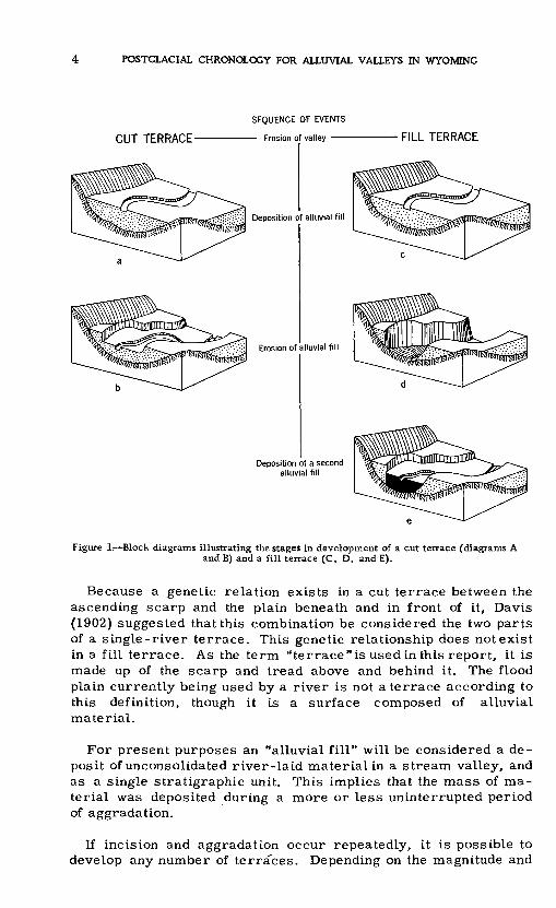
By common usage, the terms "cut terrace" and "fill terrace" apply to remnants of former floors of alluvial valleys. Terraces cut into bedrock are generally called "strath terraces. " The latter do occur in the area studied, but this paper is concerned primarily with recent alluvium and with cut and fill terraces.
The development of a cut terrace is indicated in diagrams A and B of figure 1. It is distinguished from a fill terrace for which the developmental stages are indicated in diagrams C, D, and E of figure 1.
In C, the initial stage is exactly the same as A of the cut ter race. The stream incised itself into the alluvial valley fill as il lustrated in D, which corresponds closely to the final stage B of a cut terrace except that the stream is pictured as having cut a deeper trench. If, thereafter, degradation ceases and the stream deposits material in its valley trench, it may attain the condition shown in E, in which the outward form of the terrace may be iden tical to B of the cut-terrace sequence. Despite the possibility of complete similarity in form, the example illustrated by diagrams C, D, and E required for its formation an additional change in regimen; that is, an aggradational, as well as the degradational, phase.
POSTGLACIAL CHRONOLOGY FOR ALLUVIAL VALLEYS IN WYOMING
CUT TERRACE-
SEQUENCE OF EVENTS
Erosion of valley FILL TERRACE
Deposition of alluvial fill
Erosion of alluvial fill
Deposition of a second alluvial fill
Figure 1. Block diagrams illustrating the stages in development of a cut terrace (diagrams A and B) and a fill terrace (C, D, and E).
Because a genetic relation exists in a cut terrace between the ascending scarp and the plain beneath and in front of it, Davis (1902) suggested that this combination be considered the two parts of a single-river terrace. This genetic relationship does not exist in a fill terrace. As the term "terrace"is used in this report, it is made up of the scarp and tread above and behind it. The flood plain currently being used by a river is not a terrace according to this definition, though it is a surface composed of alluvial material.
For present purposes an "alluvial fill" will be considered a de posit of unconsolidated river-laid material in a stream valley, and as a single stratigraphic unit. This implies that the mass of ma terial was deposited during a more or less uninterrupted period of aggradation.
If incision and aggradation occur repeatedly, it is possible to develop any number of terraces. Depending on the magnitude and

NOMENCLATURE FOR ALLUVIAL TERRACES 5
the sequence of deposition or erosion, any number of fills or dif ferent stratigraphic units could be deposited. The number of fills and terraces constitutes part of a logical classification of alluvial valleys.
Figure 2 presents nine possible examples representing differ ent numbers of terraces developed in valleys having various num bers of alluvial fills. The three examples in the group marked A show no terraces in valleys having one, two, and three alluvial fills. Similarly, the possibilities for valleys with one and two terraces are pictured in groups B and C, respectively.
A. NO TERRACE
B. ONE TERRACE
1 ONE ALLUVIAL FILL
C. TWO TERRACES
TWO ALLUVIAL FILLS THREE ALLUVIAL FILLS
Figure 2. Examples of valley cross sections showing some possible stratigraphic relations invalley alluvium.
Example 1A will be called a "1-fill, no-terrace alluvial valley, " and example 3C will be a "3-fill, 2-terrace alluvial valley. " The nomenclature can be extended to include any combination of numbers.
Another set of words is needed in order to designate the strati- graphic relations of the alluvial deposits. During the later two periods of alluviation, the gully or valley cut in the earlier allu vium may be only partly filled, as pictured in figure 3, cross section A, in which the later alluvial fill is "inset" in relation to the earlier. In cross section B, the later alluvial fill has an "overlapping" relationship to the earlier one; that is, the second fill was of sufficient volume to overflow the valley cut into earlier alluvium.

POSTGLACIAL CHRONOLOGY FOR ALLUVIAL VALLEYS IN WYOMING
ASecond fill "inset" Second fill 'overlapping"
Figure 3. Valley cross sections illustrating "inset" and "overlapping" relations of twoalluvial fills.
Both of the examples in figure 3 represent. 2-fill, 1-terrace alluvial valleys. In such a valley, the condition of an inset fill implies that following deposition of the first fill there was erosion, followed again by deposition which only partly filled the valley. In the development of an overlapping second fill, the first deposition was followed by erosion, after which occurred a second period of deposition, followed again by erosion.
In places where there are several fills and several terraces, the permutations possible become large because of the fact that any given fill could be either inset or overlapping the preceding one. Thus, in figure 2, the stratigraphic relations shown are not the only ones which would provide the combinations of multiple terraces and multiple fills.
GENERAL' RELATIONS OF TERRACES AND ALLUVIAL FILLS IN WYOMING
The several river basins discussed in this report are shown in the map, figure 4. The most detailed work was done in the basins of the Powder, Belle Fourche, and upper Cheyenne Rivers, and somewhat less detailed work in the Little Bighorn, the middle reaches of the Bighorn, and the North Platte Rivers.
The rivers drain, for the most part, undulating plains where rainfall is relatively low, 12 to 16 inches a year, and where vege tation is sparse. Semidesert shrub and short-grass prairie asso ciations dominate much of the area, and woodland is next in areal extent. The headwaters of nearly all of these rivers are in high mountains, but the high country constitutes only a small part of the total area.
On the undulating plains remnants of extensive pediment surfaces can be seen. Near the mountains particularly, these surfaces, generally covered with gravel, are distinct and from a distance appear as giant staircases leading spectacularly down toward the

GENERAL RELATIONS OF TERRACES AND ALLUVIAL FILLS IN WYOMING
Figure 4. Location map showing area discussed in this report.
present river bottoms. These surfaces in some areas have been described in detail (Blackwelder, 1914; Mackin, 1937) and are not considered here.
The present study deals with much younger and smaller features, the alluvial terraces which border the present streams. In all of the river basins studied, there are generally three such terraces, and all three are present so consistently that they are indeed a characteristic feature of the valleys. The general aspect of these terraces and the sequence of deposits underlying them are pictured diagramatically in figure 5. Their topographic characteristics will be discussed first.
The highest and oldest alluvial terrace, called the Kaycee, stands 20 to 50 feet above the present streams. From the scarp of the Kaycee terrace, wash-slopes characteristically sweep in gentle upward curves toward the drainage divides.

8 POSTGLACIAL CHRONOLOGY FOR ALLUVIAL VALLEYS IN WYOMING
A middle terrace, called here the Moorcroft, stands commonly 8 to 12 feet above the streams. It is generally somewhat narrower than the lowest terrace and is separated from it by an abrupt scarp.
The lowest terrace, called here the Lightning, stands 4 to 7 feet above the streams, and at first glance appears to be the flood plain. In some reaches it probably is the modern flood plain, but generally there is present a slightly lower, narrow, and relatively incon spicuous flat bordering the stream, which is actually the present flood plain. In most reaches the Lightning terrace does not appear to be overflowed by modern floods.
These topographic characteristics are shown in the generalized cross section of figure 5. In certain places, one or more of the features just described are missing, but despite the exceptions, the relations are so amazingly consistent that they would attract the attention of most observers. There is also a consistency in the sequence of deposits forming the respective terraces.
The Kaycee terrace is underlain by more than one stratigraphic unit, as can be seen in figure 5, and as will presently be described. The surface has a definite soil profile characterized by a columnar or cloddy structure and a recognizable B horizon slightly mottled with whitish calcium carbonate.
The Moorcroft, the middle of the three terraces, is in most places a cut terrace underlain by the same silty formation that constitutes the top stratum of the highest, or Kaycee, terrace. No soil profile is developed on the Moorcroft terrace, although in places some humic darkening can be seenin the upper few inches.
The Lightning terrace is generally composed of an inset fill con sisting of silt and fine sand. No evidence of soil formation is present near the surface.
A summary of the physical characteristics of these alluvial materials follows. It provides a generalized and composite picture of the various exposures Which are discussed individually later.
ARVADA FORMATION
The oldest alluvial material found in the valleys which were studied is named here the Arvada formation. The material consists of highly weathered gravel or gravelly sand, generally stained red but containing many cobbles stained with a yellow or yellow-brown of limonite. The beds present ample evidence of frost action, in cluding fossil ice wedges and contortions. The formation contains bones of late Pleistocene extinct mammals. Where the next younger alluvial formation, the Ucross is absent, the carbonate-rich pale- osol may be imposed on the upper part of the Arvada formation.

GENERAL RELATIONS OF TERRACES AND ALLUVIAL FILLS IN WYOMING

10 POSTGLACIAL CHRONOLOGY FOR ALLUVIAL VALLEYS IN WYOMING
The type locality for the Arvada formation is at the west abutment of the highway bridge across the Powder River on Highway 16, 3 miles north of Arvada, Wyo.
UCROSS FORMATION
The gravelly deposits of Recent age discomformably overlying the Arvada formation are here designated the Ucross formation. Its type locality is in Clear Creek valley, 1 mile south of Ucross, Wyo. The deposits consist of fresh, rounded gravel including a variety of rocks, mostly igneous and metamorphic, derived from mountain areas. The pebbles in the gravel average 1 to 2 inches in diameter. The formation contains occasional deeply weathered yellow-stained and red-stained pebbles. The upper few feet of the formation may locally be composed of silt and may contain lenses of clay.
The upper 2 to 3 feet of Ucross formation is characteristically impregnated with large amounts of calcium carbonate and gypsum in the form of strong white mottlings, concentrically-filled tubules, and hard nodules 1/8 to 1 inch in diameter. The carbonate and gypsum concentrations on the lower side of cobbles in fibrous or crystalline masses are as much as 3/4 of an inch thick. The accumulation of carbonate and gypsum is sufficiently great to give the zone a whiteness that can be seen even from a distance. The carbonate and gypsum are considered to be analogous to a caliche crust which accumulates at the ground surface where evaporation concentrates the salts brought to the locality by ground water or lateral movement of vadose water. A caliche crust by its mode of formation will not be associated with a leached A horizon. Though such a crust is not a typical soil profile, it is a zone of surface weathering and if it were formed at some time in the past rather than under present conditions, it would be called paleosol.1
The paleosol is absent in places and the next younger formation, the Kaycee, lies unconformably on fresh gravel that is believed to be Ucross in age. This sequence is explained by the fact that a period of erosion followed the formation of the Ucross and during it the carbonate zone was in places removed.
KAYCEE FORMATION
The formation underlying the Moorcroft terrace and comprising the upper part of the alluvium of the Kaycee terrace is here called the Kaycee formation. As indicated in figure 5, the Kaycee terrace characteristically sweeps in smooth wash slopes toward the inter- stream divides. Slope wash and colluvium interfinger with the
iPaleosol is a term introduced by Hunt and Sokoloff (1950) to describe an ancient soil one formed under climatic conditions different from the present.

GENERAL RELATIONS OF TERRACES AND FILLS IN WYOMING 11
contemporaneous river-laid deposits, and both colluvium and river alluvium are considered in the Kaycee formation. The type locality is designated as the left bank in the reach of the Powder River from Kaycee to Sussex, Wyo.
The Kaycee formation is of Recent age. Its surface has a clearly defined soil profile characterized by humic darkening through a depth of 1 to 2 feet. The soil tends to be columnar or cloddy in structure and its B horizon is mottled white by a concentration of calcium carbonate. Nodules of calcium carbonate are absent.
The Kaycee formation consists of uniform tan or light-brown silt consisting of moderately well sorted grains, predominantly quartz. The grains are subrounded but not pitted. The large amount of silt suggests the possibility of an aeolian source, but the material is not sufficiently well sorted or pitted to assign ae olian processes a major role in its origin. Lenses of sand or fine gravel are locally present. In places there is a thin basal gravel. Bones of Bison bison are common, and no extinct animal remains have been found.
LIGHTNING FORMATION
An alluvial fill of Recent age consisting of light-brown to tan, silty, fine or medium sand containing occasional lenses of fine gravel or coarse sand but generally devoid of bedding is here named the Lightning formation. No bones or artifacts have been found in this formation. No soil profile exists at its surface. Thickness varies from 3 to 10 feet. The type locality is designated as the reach of Lance Creek in the immediate vicinity of the town of Lance Creek, Wyo.
The sequence of events leading to the development of the various stratigraphic units and the terraces is summarized in table 1.Table 1. Chronology of events indicated by the alluvial terraces and under/ying deposits
in Wyoming
[Events arranged in order from oldest to youngest]
Bedrock eroded to form river valleys, strath terraces, pediments, and other features.
Deposition of gravels: Arvada formation. Weathering of Arvada formation to deep red. Erosion of Arvada formation.
Deposition of gravels near mountains and fine-grained alluvium at distance from mountains:Ucross formation.
Development of soil (strong calcium carbonate accumulation). Erosion.
Deposition of fine-grained alluvium: Kaycee formation.Trenching of the Kaycee formation, forming the Kaycee terrace and the tread of the Moorcroft
terrace, cut on Kaycee formation.
Period of stability during which streams flowed at height of Moorcroft terrace tread, which is acut terrace.
Erosion; incision of stream forming the Moorcroft terrace.
Deposition of fine-grained alluvium: Lightning formation.Slight trenching of Lightning formation forming the Lightning terrace.

12 POSTGLACIAL CHRONOLOGY FOR ALLUVIAL VALLEYS IN WYOMING
CRITERIA FOR CORRELATING TERRACES
The principles of terrace correlation are generally understood, and have been utilized by geomorphologists and archeologists in such problems as dating culture horizons and interpreting the al pine glacial sequence. Application of these principles, however, involves so many problems that the techniques and criteria are by no means uniform. In fact, the differences are so apparent in the literature that it seems necessary to consider the problems here, and to develop the reasoning which underlies the terrace corre lations proposed herein.
Alluvial terraces must be correlated on the basis of terrace morphology and stratigraphic characterictics of the alluvial ma terials of which the terrace is composed. Morphologic charac teristics which may be useful in correlation are the continuity and .height of terraces, and the physiographic relation of the terrace to other land forms, such as higher hills and lower terraces. Stratigraphic methods may be employed to determine the deposi- tional characteristics and lithology of the alluvial fills, and the relation of the fills to certain horizon markers, such as uncon formities, fossil zones, and buried soils. Each criterion used for correlation purposes in this report will now be discussed briefly.
CONTINUITY AND HEIGHT
The most important criterion for identifying a stream terrace is based on the premise that during a period of relative stability the stream cut a surface or built a flood plain, either of which was more or less continuous along the valley. When the stream cut down below this surface, thus forming a terrace, erosion by lateral swinging of the main stream and down-cutting by tribu taries partly or completely eliminated the original surface. If such erosion has been slight, the terrace remnants will b*e rela tively continuous along the valley and will be at a uniform or uni formly changing height above the present stream bed. Terrace remnants, furthermore, will in places be of essentially the same height on both sides of the streams, or, in other words, paired. The continuity of a surface along the valley and a tendency for it to have a uniform height above the present stream thus become primary criteria for a terrace system.
In contradistinction, a progressively down-cutting stream will leave along the valley sides isolated flats which are never paired, and are of irregular height because they are not remnants of a single continuous surface (Davis, 1902).
A river plain sufficiently continuous to be called a terrace tread after the down-cutting of the river usually remained the active flood plain for a long enough period of time to form the local base

CRITERIA FOR CORRELATING TERRACES 13
level to which side tributaries and ephemeral washes from the valley sides were graded. Mackin (1937) has described how slope wash from the valley sides splays over the flood plains of the main river and may build a continuous surface sloping toward the valley axis» In the Bighorn Basin near Cody, Wyo., where this process was described by Mackin, stream-bed gravel covered by a thin layer of fine-grained alluvium, -characteristically repre sents the original flood plain. The difference in texture between the gravel and the overlying slope wash was so distinctive that differentiation presented no problem. The elevation of the top of the gravel was used by Mackin as the height of the river terrace.
Alluvial terraces, generally of more recent origin than those described by Mackin, characteristically do not exhibit a sharp textural break between deposits of the main stream and slope wash. In fact, the materials are generally so nearly identical that the criteria usable in the Bighorn Basin cannot be applied. The heights of terrace remnants above the present stream are not everywhere uniform, but show a range of values, because the height measured includes an unknown thickness of slope wash.
It is necessary, then, to restrict measurement of terrace height to sections of the valley where a cross profile will provide an in tersection of the extension of the wash-slope surfaces. This method has been used by Peltier (1949).
Topographic profiles representing three sections across the valley of the Powder River near Arvada, Wyo., are presented in figure 6. In cross section A, a gently sloping surface extends from the hills nearby toward the valley axis and is cut off by a scarp near the valley axis. In the field, this scarp is prominent and at many places vertical. The top of this scarp stands 60 feet above the river. The dashed line representing the projection of the wash-slope surface of the left side of the valley intersects the right bank well above the present stream level. This example demonstrates that the river level to which the wash slope was graded stood no less than 35 feet above the present stream at this point.
Cross section B of figure 6 is 1.8 miles downstream from cross section A. The top of the gently rounded scarp on the left bank stands 60 feet above the river and, from field indications, is a remnant of the same terrace shown in cross section A. Yet, pro jecting the wash-slope surface down to intersection with the right bank shows that the surface on the left bank could have been de veloped when the river stood at the level of a lower terrace about 20 feet above the present stream.
In cross section C a scarp appear son both banks of the river. Each wash-slope surface is shown extended toward the valley axis by dotted lines which intersect 35 to 40 feet above the present stream.

14 POSTGLACIAL CHRONOLOGY FOR ALLUVIAL VALLEYS IN WYOMING
3700
3600
3700*^*
MILE 10.6'* """- xx"V X- ^
3600
B
3800'
_ =x_ - MILE 24-°3700' ~~~'"
500 0 1500 Feet1 I
Figure 6. Cross sections of the valley of the Powder River near, Arvada, Wyo., showing how the extension of the profile of wash slopes to intersection fixes the minimum elevation of the master stream to which the wash slopes were graded. (River miles refer to U. S. Geological Survey maps, Powder River above Moorhead, Wyo., 1947.)
In two cross sections (A and C) it appears that the river to which this particular terrace surface was graded stood at least 35 feet above the present stream. If many cross sections are considered, and if a preponderance of them shows an intersection of the extended surfaces well above the present river, one must believe that the terrace treads were developed during a time when the main stream flowed at a higher elevation than it does at pre sent. If, furthermore, there is a consistency in the height of in tersection of the extended surfaces above the present stream, it is reasonable to believe that those remnants belong to the same terrace and were developed at the same time.
In the present study, considerable reliance was placed on height of the terrace remnants as a basis for correlation, but terrace height was used in conjunction with other criteria, as will now be explained.

CRITERIA FOR CORRELATING TERRACES 15
PHYSIOGRAPHIC RELATIONS TO OTHER LAND FORMS
Many western stream valleys typically show several alluvial terraces standing at different heights above the present stream. The highest terrace is oldest and the lower terraces are progres sively younger, this being the only age relation possible which would result in the preservation of the terrace features.
When the stream stood at the level represented by a particular^ terrace, it constituted the local base level to which side tribu taries were graded. The longer the period represented by a par ticular terrace, the better developed should be the drainage pat tern graded to that surface. In a valley exhibiting two or three alluvial terraces, side tributaries would dissect the terraces while the governing" base level (the main stream) was being low ered. It would be expected that the lower and younger terraces would have a smaller area graded to them than the higher and older ones.
The relative amount of area graded to each of the three ter races studied was useful as corroborative evidence in correlation.
STRATIGRAPHIC RELATIONS OF TERRACE FILLS
Distinguishing alluvial fills of different ages and determination of stratigraphic sequence of the fills, as indicated in figure 2, follow ordinary stratigraphic principles. The fills may differ in color, lithology, texture, consolidation, in contained shells, bones, or other vertebrate remains. Actually, however, alluvial ma terials in any given western valley are amazingly similar. In the area described in the present report, uniformity of texture and color is a striking characteristic of the fine-grained alluvial de posits. Though local variations in both texture and color may be found, fine sand and silt of tan color are most common. Bedding is generally not apparent because of uniformity of texture and color. The fills are composed largely of detrital quartz grains and minor amounts of other minerals. The color varies much more in a given fill depending on temporal conditions of moisture than between fills of different ages. The color of dry alluvium is ordinarily a buff or tan, and wet alluvium is reddish to chocolate.
The degree of consolidation also depends primarily on moisture content. When perfectly dry, the alluvium is not only hard but tough, and a pick or chisel point penetrates only a fraction of an inch, even with a hard blow. When moderately moist, silty allu vium is soft. For this reason, consolidation was not a useful cri terion for correlation in this study.

16 POSTGLACIAL CHRONOLOGY FOR ALLUVIAL VALLEYS IN WYOMING
The banding of many alluvial fills is due either to slight varia tions in texture in the vertical direction or to varying amounts of humic stain. In the area studied, however, these prevalent bands are characterized by a lack of continuity in the horizontal direc tion and were seldom useful for correlation purposes.
Thus, the identification of the different stratigraphic units in alluvial deposits along western rivers is difficult, and even a good exposure, as for example where the terrace deposits are dis sected, may or may not provide conclusive proof of whether the terrace was formed by cutting or filling.
Characteristics such as rounding of gravels, size and sorting of particles, and nature of bedding aid in determining whether allu vial fills were deposited by the major stream, by slope wash, by aeolian action, or by some other means. Because of the interfin- gering of slope wash with the flood-plain deposits, however, these characteristics do not provide a definite field criterion for differ entiating alluvium of different ages.
Faunal and floral zones were rare in the alluvium studied, the most common fossils being vertebrate bones (Bison especially) and snail shells. Such zones, where found, are not useful for corre lation purposes because the ranges of species represented have not been established. In fact, dating of faunas in alluvial deposits at the present time depends on dating of the alluvial terraces by whatever methods are available. In general, extinct species of vertebrates are not reported in deposits younger than Mankato (see Schultz, Lueninghoener, and Frankforter, 1951, table 1; Bryan, 1950, p. 122-123).
A horizon useful for correlation in the area studied was the paleosol previously mentioned. Where present in materials un derlying a terrace, it invariably lay stratigraphically below the youngest alluvial fill comprising the high terrace, the Kaycee formation.
In summary, correlation in this study depended primarily on a combination of three factors: 1. Height of terrace remnants above the present stream. 2. Physiographic and topographic relation of the terraces to one another and to other land features. 3. The ex istence of a zone in which there is a concentration of carbonate and gypsum, which is interpreted as a paleosol.
No single criterion was sufficient to identify a particular alluvial formation or a given terrace or to permit correlation over a wide area, but these criteria consisting of topographic andstratigraphic relations used in combination allowed correlation with reasonable confidence.

RELATIONS OF TERRACES AND ALLUVIAL FILLS IN VARIOUS RIVER BASINS
The authors are well aware of the many possible sources of error in such correlation and of the shortcomings of the recon naissance type of work discussed here. The correlations are for that reason considered tentative.
RELATIONS OF TERRACES AND ALLUVIAL FILLS IN VARIOUS RIVERVALLEYS
POWDER RIVER BASIN
The Powder River basin will be discussed first because more detailed work was done in this basin than in any other. Also, many of the sites whose names are used for various parts of the alluvial sequence discussed herein are along the Powder River or its tributaries. The excellent topographic maps of the Powder River basin greatly facilitate geologic investigation of this river as compared with the other river basins for which relatively few maps are available.
There are three prominent terraces along the Powder River, which are pictured in figure 7. As will be shown in the following description, this is a 4-fill, 3-terrace alluvial valley in which the three oldest fills are successively overlapping and now make up the deposits of the high terrace.
Figure 7. Terraces along the Powder River, Wyo.
18 POSTGLACIAL CHRONOLOGY FOR ALLUVIAL VALLEYS IN WYOMING
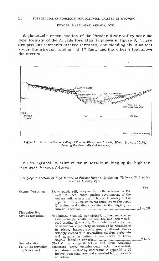
POWDER RIVER NEAR ARVADA, WYO.
A planetable cross section of the Powder River valley near the type locality of the Arvada formation is shown in figure 8. There are present remnants of three terraces, one standing about 55 feet above the stream, another at 17 feet, and the other 7 feet above the stream.
3700-
3600-
3500'-1
U.S.G.S. datum
'Bedrock is Fort Union formation
Based on planetable survey
Figure 8. Cross section of valley of Powder River near Arvada, Wyo. , (at mile 10.6), showing the three alluvial terraces.
A stratigraphic section of the materials making up the high ter race near Arvada follows:
Stratigraphic section of high terrace of Powder River at bridge on Highway 16, 3 milesnorth of Arvada, Wyo.
Kaycee formation:
Disconformity. Arvada formation:
Unconformity. Ft. Union formation:
(Pal eocene)
Brown sandy silt, comparable to the alluvium of the lower terraces; shows profile development of the modern soil, consisting of humic darkening of the upper 6 to 8 inches, columnar structure in the upper 24 inches, and caliche mottling in the slightly in durated B horizon.............. ..... ....
Feet
..1 to 10
Red-brown, rounded, iron-stained, gravel and coarse sand, strongly weathered near top and less weath ered grading downward. Many cobbles of siltstone or sandstone completely uncemented by weathering in place. Igneous rocks greatly altered. Rocks Strongly coated with crystalline calcium carbonate and gypsum on bottom sides. Tooth of horse (Eguus) found in gravels...............................................
(Marked by congeliturbation and frost wedges.) Sandstone, gray, noncalcareous, soft, uncemented,
and stained yellow by weathering in upper 20 to 30 inches, becoming gray and somewhat better cement ed below.
.2 to 5
RELATIONS OF TERRACES AND ALLUVIAL FILLS IN VARIOUS RIVER BASINS 19
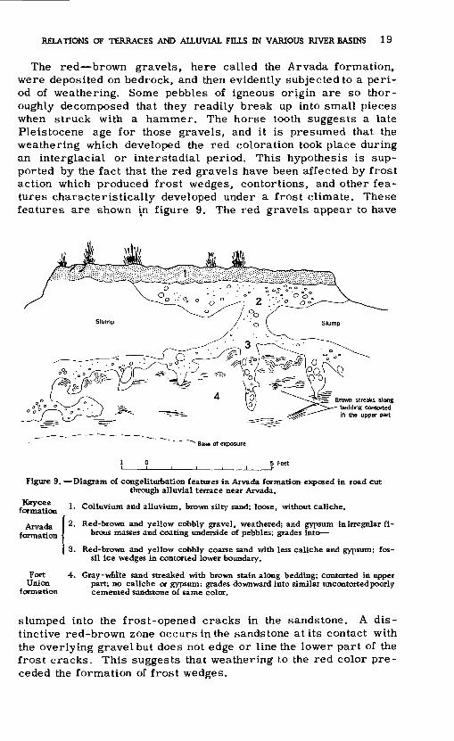
The red brown gravels, here called the Arvada formation, were deposited on bedrock, and then evidently subjected to a peri od of weathering. Some pebbles of igneous origin are so thor oughly decomposed that they readily break up into small pieces when struck with a hammer. The horse tooth suggests a late Pleistocene age for those gravels, and it is presumed that the weathering which developed the red coloration took place during an interglacial or interstadial period. This hypothesis is sup ported by the fact that the red gravels have been affected by frost action which produced frost wedges, contortions, and other fea tures characteristically developed under a frost climate. These features are shown in figure 9. The red gravels appear to have
rown streaks along bedding contorted in the upper part
Base of exposure
Figure 9. Diagram of congeliturbation features in Arvada formation exposed in road cut through alluvial terrace near Arvada.
Kaycee formation
Arvada formation
FortUnion
formation
1. Colluvium and alluvium, brown silty sand; loose, without caliche.
2. Red-brown and yellow cobbly gravel, weathered; and gypsum in irregular fi brous masses and coating underside of pebbles; grades into
3. Red-brown and yellow cobbly coarse sand with less caliche and gypsum; fos sil ice wedges in contorted lower boundary.
4. Gray-wnite sand streaked with brown stain along bedding; contorted in upper part; no caliche or gypsum; grades downward into similar uncontortedpoorly cemented sandstone of same color.
slumped into the frost-opened cracks in the sandstone. A dis tinctive red-brown zone occurs in the sandstone at its contact with the overlying gravel but does not edge or line the lower part of the frost cracks. This suggests that weathering to the red color pre ceded the formation of frost wedges.

20 POSTGLACIAL CHRONOLOGY FOR ALLUVIAL VALLEYS IN WYOMING
Widespread erosion followed, as indicated by the fact that the Arvada formation is preserved as small, widely separated rem nants. This erosion was generally followed by deposition of the Ucross formation, but as will be noted in figure 8, at this expo sure (mile 10. 6) the Ucross formation which is the formation next younger than the Arvada, (see fig. 5), is absent. In most other areas the Arvada formation is absent, but the Ucross formation in places contains weathered, iron-stained fragments which are pre sumed to have been derived from the Arvada formation. The exact amount of erosion that occurred is unknown because later depo sition buried most remnants of the Arvada formation and very few of these have been reexposed.
The marked concentration of calcium carbonate and gypsum in the gravelly Arvada formation at mile 10. 6 is interpreted as the result of soil-forming processes later than and different in char acter from those which produced the red color. The carbonate and gypsum are characteristic of the post-Ucross paleosol, a soil formed earlier than the deposition of the fine-grained Kaycee formation. The concentration of carbonate and gypsum extends through the entire thickness of the Arvada formation, including the frost-heaved zone. The cobbles in and above the frost cracks are coated on their lower sides with carbonate and gypsum in the form of coarsely crystalline crusts as much as three-quarters of an inch thick. There is no evidence of disturbance by frost after the ac cumulation of carbonate and gypsum. From this it is concluded that the carbonate and gypsum deposition occurred after the period of frost action. Samples were taken from the site at Arvada and analyzed in the laboratory for calcium carbonate. It was found that calcium carbonate was essentially absent in the Kaycee allu vium. The amount of it at the top of the Arvada formation was 6.4 percent, and it decreased downward to none at the gravel and sandstone contact. Examination with the petrographic microscope and by X-ray techniques showed that gypsum was even more abun dant than carbonate, and it also decreased in amount downward from the top of the Arvada.
At the end of or after the period of carbonate and gypsum ac cumulation just described, erosion removed a part of the soil in many places and in others destroyed the soil completely. Subse quent deposition of the Kaycee formation buried the ancient soil at Arvada and other places where it had not previously been de stroyed by erosion. Since deposition of the Kaycee formation, suf ficient time has elapsed for a shallow soil profile to develop on the smoothly sloping surface of the Kaycee terrace at Arvada. The two lower terraces show no distinct soil profile development.
An additional type of evidence regarding age of the high-terrace surface was found at the Arvada site. Abundant chips of flint of heterogeneous kinds were found scattered over the surface of the Kaycee terrace. Most showed definite evidence of having been

RELATIONS OF TERRACES AND ALLUVIAL FILLS IN VARIOUS RIVER BASINS 21
chipped by man, partly by a percussion technique. These worked flakes were conspicuously absent from the surface of the middle terrace and might pre-date construction of that terrace.
POWDER RIVER NEAR SUSSEX, WYO.
The cliffs along the left to Sussex, Wyo., provide for the Kaycee formation, is reproduced in figure 10. 53 feet above the stream,
bank of the Powder River from Kayceean exposure which is the type locality
The valley cross section at this pointRemnants of the Kaycee terrace standand projection of the sloping terrace
4300-1 U.S.G.S datum
/Paleosol Kaycee formation ^ -Ucross formation
Lightning formation t^S^r.
Bedrock is - Wasatch formation
Based on planetable survey
Figure 10. Cress section of valley of Powder River near Sussex, Wyo., showing the threealluvial terraces.
surface shows that it was graded to the Powder River when the channel was at least 40 feet higher than at present. Relations of the deposits that make up the high terrace are shown in the strati- graphic section which follows, and by the photograph in figure 11.
The bulk of the Kaycee formation consists of alluvium laid down by the stream as valley fill. Colluvial deposits and slope wash that interfinger and were graded to the river deposits are contem porary and are, therefore, included in the Kaycee formation.
The whitened calcareous zone distinctly shown in figure 11 lying beneath the Kaycee alluvium and at the top of the Ucross formation is interpreted as a paleosol. The paleosolat Sussex differs some what in character from the one at Arvada in that no significant quantity of gypsum was found. Analysis of the whitened zone showed 15. 5 percent calcium carbonate in the upper foot and grad ually decreasing concentrations downward in the section. In places

22 POSTGLACIAL CHRONOLOGY FOR ALLUVIAL VALLEYS IN WYOMING
Figure 11. Exposure near top of Mgh terrace near Sussex, Wyo.
Stratigraphic section of high terrace on Powder River cliff one-quarter miles westof Sussex, Wyo.
Kaycee formation:
Ucross formation:
Unconformity. Wasatch formation:
(Eocene)
FeetFine, tan, silty alluvium consisting primarily of
quartz grains. Surface soil profile characterized by well-developed columnar structure to a depth of about 3 feet; no distinct humus zone near the sur face; slightly calcareous from a depth of about 10 inches. Grades downward into Ucross formation...........3 to 6
Gray or white silt, with some gravel in the lower part, containing a high concentration of calcium carbonate. (Grades into next bed).........................................! to 2Gravel and sand, calcium carbonate crusts on the bottom sides of cobbles and pebbles. Gravel and sand, mostly unweathered, except in upper parts, but there are a few iron-stained rocks. Grades downward into 2 to 3 feet of fine, gray sand con taining clay lenses. Shows strongly developed red- brown layers due to iron concentration................................ 7 to 10
Gray to light-green shale.

RELATIONS OF TERRACES AND ALLUVIAL FILLS IN VARIOUS RIVER BASINS 23
where the Kaycee alluvium has been removed, the modern surface soil has developed on the paleosoland has in the upper 6 to 8 inches partially destroyed the strongly calcareous characteristics of the paleosol. Such a soil profile is polygenetic.
In the Sussex area, the two lower terraces stand at 23 feet and 5 feet, and are composed of light-tan, fine-grained alluvium.
Two important sites on Clear Creek, a tributary of the Powder River, will now be discussed. Though there are some differences in detail, these two sites indicate a sequence similar to that sug gested by the two areas on the Powder River previously described.
CLEAR CREEK SOUTH OF UCROSS, WYO.
A planetable cross section of Clear Creek valley, 1 mile south of Ucross, Wyo., (at the ranch of Ike Thomas) is shown in figure 12. At this point the Kaycee terrace stands 17 feet above the
^Section in figure 13 at this point 100' i
Ucross formation
Bedrock is Wasatch formation' N Lightning formation
Arbitrary datum
Based on planetable survey
Figure 12. Cross section of valley of Clear Creek at Thomas's ranch near Ucross, Wyo. The three alluvial terraces can be seen.
stream, and is composed of gravel and fine-grained alluvium. The upper 50 inches consists of tan, silty alluvium, the upper part of which has a columnar structure and a brown color typical of the modern soil on the Kaycee formation. Below this depth is a se quence of silt and unweathered gravel which are the type materials of the Ucross formation. The stratigraphic relation is inter preted as a calcareous paleosol developed on the upper part of

24 POSTGLACIAL CHRONOLOGY FOR ALLUVIAL VALLEYS IN WYOMING
the Ucross formation. Overlying the paleosol is the Kaycee formation.
Samples taken in the Kaycee and Ucross formation making up the 17-foot terrace were studied in the laboratory, with results summarized in figure 13. It should be noted that the Kaycee alluvium itself is calcareous, but there is a zone of markedly increased calcium carbonate concentration at 60 to 75
40
60
120
0 30 PERCENT CaCO, pH
Figure 13. Changes in cqptent of calcium carbonate and in pH with depth in the Kaycee ter race alluvium at Thomas's ranch near Ucross Wyo. The stratigraphic units are shown in the profile at the right of the figure.

RELATIONS OF TERRACES AND ALLUVIAL FILLS IN VARIOUS RIVER BASINS 25
inches. In this zone, which is interpreted as the paleosol layer, the carbonate is present as soft, irregular masses dispersed through the silt, and also as-hard nodules as much as 1 centimeter in diameter and containing as much as 45 percent carbonate. As was true at the sites on the Powder River, the paleosol. is an im portant stratigraphic marker and provides in this section the log ical basis for distinguishing the Ucross and Kaycee formations.
The samples consisted of a material dug from a thin horizontal groove made with a knife. They were taken every few inches ver tically so that the changing relations with depth from the terrace surface could be determined. Parts of each sample were ex amined by the Rolfe technique (Rolfe and Jeffries, 1952) to ascer tain the relative amount of weathering with depth.
The results of the analysis indicated moderate hydration of micas (an indication of weathering) at the surface, gradually decreasing with depth. At a depth of 50 inches the hydration of micas abruptly increased to a degree even greater than existed at the surface. The indication of weathering provided by the Rolfe technique and the coincident stratigraphic evidence of the paleosol provide con vincing confirmation of the existence of the paleosol.
Detailed mechanical analyses of the entire sequence of fine al luvium above the basal formation of the Ucross were made. The median diameter ranges from 0. 028 to 0. 050 millimeter, and averages 0. 037 millimeter. The Trask sorting coefficient ranges from 2. 1 to 3. 2 and averages 2. 5. There are no significant dif ferences in size and sorting of the silt above, below, or in the paleosol horizon.
Mineral composition was determined by petrographic and X-ray techniques. Sixty to 90 percent of the fine alluvium is quartz, and the rest is dominantly calcite, though with minor amounts of bio- tite, chlorite, and clay minerals. The clay size fraction of 2 mi crons was separated from each sample and analyzed with the X- ray spectrometer. Illite and montmorillonite are the most com mon clay minerals and are present in nearly equal quantities throughout the fine alluvial sequence. Kaolinite is present only as traces, except in the lower part of the paleosol horizon, where it appears in significant quantities.
The sequence at Ucross seems to be the same as that at Sussex and conforms to the generalized section in figure 5 except that the Arvada formation is missing. The many highly iron stained peb bles and cobbles in the Ucross formation suggest that strongly- weathered material (Arvada (?) formation) was mixed with relatively unweathered gravels during deposition of the Ucross formation. The Ucross here and at Sussex consists of basal gravels overlain by silt, and the paleosol is developed on the silt. In many places the Ucross consists of gravel without any silty strata.

26 POSTGLACIAL CHRONOLOGY FOR ALLUVIAL VALLEYS IN WYOMING
The middle and low terraces are fairly prominent in the vicinity of Ucross and stand 7 feet and 3 feet alSove the stream, respec tively. As shown in figure 12, the middle terrace bears a cut rath er than a fill relationship to the high terrace.
This cut relationship is well demonstrated by an exposure about 1 mile upstream from Clearmont, Wyo., pictured in figure 14. The terraces shown in the photograph are the Kaycee and Moorcroft sur faces. In figure 14, the gravels of the Ucross formation underlie silt of the Kaycee formation, but any soil developed on the gravel apparently had been eroded away before the deposition of the silt of the Kaycee.
"* II « sa*-.
Figure 14. Section through Kaycee and Moorcroft terraces near Clearmont. Wyo.
CLEAR CREEK AT BUFFALO, WYO.
A planetable cross section of Clear Creek valley 1 mile east of Buffalo, Wyo. , is shown in figure 15. At this point remnants of the Kaycee, or high, terrace stand 19 to 23 feet above the stream. The stratigraphic section of the Kaycee terrace comprises a gravel layer, considered equivalent to the Ucross formation, overlain by

RELATIONS OF TERRACES AND ALLUVIAL FELLS IN VARIOUS RIVER BASINS 27
a fine grained alluvium consisting of a combination of stream de posits and slope wash, both of Kaycee age.
Figure 16 refers to this zone
r
Lightning formation
-- ........................................ Wasatch formation
Kaycee formation Arbitrary datum
^^H 500 0 1000 Feet Paleosol ' ' ' ' ' ' ' '
Ucross formation
____ Based on planetable survey
15. Cross section of Clear Creek valley near Buffalo, Wyo. The three alluvial terraces arewell developed.
The Lower terraces are also present at Buffalo, standing 12 feet and 4 feet, respectively, above the present stream. The middle terrace is composed locally of either fine grained alluvium or small gravel or both, whereas the low terrace is made up of sand and silt except for a short reach near the mountain where it is gravel. Here again the paleosol is a conspicuous feature, and its relationships are easily recognized.
Laboratory analyses of soil samples collected at three points chosen in aline perpendicular to the axis of the valley demonstrate the relation of the paleosol to the bedrock and alluvium. Figure 16 includes a more detailed cross section at the same locality shown in generalized form in figure 15. The Kaycee terrace slopes toward Clear Creek and ends in an abrupt scarp which rises 23 feet above the present stream. River valley silt is indistinguish able from slope wash which thins upslope. The slope is a smooth, unbroken slightly concave, curve which passes upslope from the silty slope wash to bedrock.
As the cross section in figure 16 indicates, the paleosol is de veloped on the original bedrock surface and passes underneath the silt of the Kaycee formation, but is present on the top of the wedge of gravel of the Ucross formation. In the upper part of the figure
303189 0-54-3
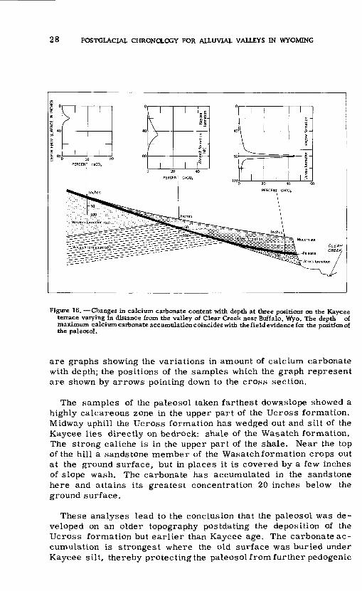
28 POSTGLACIAL CHRONOLOGY FOR ALLUVIAL VALLEYS IN WYOMING
Figure 16. Changes in calcium carbonate content with depth at three positions on the Kaycee terrace varying in distance from the valley of Clear Creek near Buffalo, Wyo. The depth of maximum calcium carbonate accumulation coincides with the field evidence for the position of the paleosol.
are graphs showing the variations in amount of calcium carbonate with depth; the positions of the samples which the graph represent are shown by arrows pointing down to the cross section.
The samples of the paleosol taken farthest downslope showed a highly calcareous zone in the upper part of the Ucross formation. Midway uphill the Ucross formation has wedged out and silt of the Kaycee lies directly on bedrock: shale of the Wasatch formation. The strong caliche is in the upper part of the shale. Near the top of the hill a sandstone member of the Wasatch formation crops out at the ground surface, but in places it is covered by a few inches of slope wash. The carbonate has accumulated in the sandstone here and attains its greatest concentration 20 inches below the ground surface.
These analyses lead to the conclusion that the paleosol was de veloped on an older topography postdating the deposition of the Ucross formation but earlier than Kaycee age. The carbonate ac cumulation is strongest where the old surface was buried under Kaycee silt, thereby protecting the paleosol from further pedogenic
RELATIONS OF TERRACES AND ALLUVIAL FILLS IN VARIOUS RIVER BASINS 29
action. Uphill, where the old surface was covered by little or no silt of the Kaycee, the paleosol was exposed to processes differ ent from those which formed it, and as a result, the carbonate was leached out in part and the present soil is polygenetic. This implies that the climate which followed the development of the paleosol was more humid than that under which the carbonate was originally deposited.
Terrace heights in the Powder River basin are summarized in table 2. Except for sections designated as made in the field by plane table mapping or visual estimates, these data represent heights determined by cross sections drawn on the Geological Survey topographic maps of the Powder River, scale 1:24, 000, contour intervals, 10 feet and 5 feet. The terrace heights taken from maps are corrected for slope wash by the intersection meth od discussed in relation to figure 6. Other values are uncorrected.
There is obviously considerable variation in height of remnants of a given terrace, but the three terraces are so consistently present and so different in average height that height as a basis of correlation is useful when combined with other criteria discussed.
Table 2. Heights of terraces, in feet, on Powdet River and tributaries
[Metnods of determining height: A, measured by telescopic alidade; E, estimated; M, fromtopographic maps]
Middle Fork Powder at mile 210Red Fork at mile 206. 5Middle Fork Powder at mile 203North Fork Powder, north of Kaycee
at bridge on Hwy. 87................Sftuth Fork Powder, south of Kaycee
at bridge on Hwy. 87...............Tributary to South Fork Powder,
south of Kaycee on Hwy. 87.......Tributary to Salt Creek, 3 miles
east Edgerton, Wyo. , on Rt. 387Powder River %mile west of Sussex,
Wyo.Dry Fork Powder RiverMiddle Fork Crazy Woman Creek,
north of Kaycee on Hwy. 87.......Poison Creek north of Kaycee on
Hwy. 87 (tributary of CrazyWaman Creek)
Powder River at mile 19. 4Powder River at mile 12. 4Powder River at ArvadaPiney Creek below KearneyPiney Creek at Ucross (mouth)Clear Creek at soil site east of
BuffaloClear Creek at Thomas ranchClear Creek near ClearmontClear Creek at Leiter
Method of determin
ation
MMM
E
E
E
E
ME
E
EMMAEE
AAAA
Kaycee (high) terrace
92520
22
35
30
55
5325
20
23X3233651213
20171425
Moorcroft (middle)terrace
57
10
10
10
10
30
2312
8
1212121754
12767
Lightning (low)
terrace
45
5
3
7
12
5?
3
74
7
2
5333
1 Minimum.

30 POSTGLACIAL CHRONOLOGY FOR ALLUVIAL VALLEYS IN WYOMING
BELLE FOURCHE RIVER BASIN
The alluvial terraces of the Belle Fourche River were studied from Carlile, Wyo., upstream about 85 miles to the headwater area-near the Pumpkin Buttes, which lie about 45 miles southeast of Gillette, Wyo.
Although there are three prominent alluvial terraces along the Belle Fourche River (see fig. 17), they are appreciably lower than
60-,
Kaycee formation i Paleosol
iia Arvada formation
20
20
140-
Arbitrary datum
300 FeetJ___I
A. NEAR BRIDGE ON U. S. HIGHWAY 14, 7 MILES DOWNSTREAM FROM MOORCROFT, WYO.
B. MOORCROFT BRIDGE ON U. S. HIGHWAY 16 (Based on planetable survey)
C. CARLILE, WYO. (Based on planetable survey)
D. STATE ROUTE 59, SOUTH OF GILLETTE, WYO. (Based on planetable survey)
Figure 17. Cross sections of the valley of the Belle Fourche River.
RELATIONS OF TERRACES AND ALLUVIAL FILLS IN VARIOUS RIVER BASINS 31
those on the Powder River. The reason for this difference is not well understood but may in part stem from the fact that the Belle Fourche is a small stream which rises on the plains east of the mountains, whereas the Powder is a major river with its sources in the strongly glaciated high mountains.
Figure 17, cross section A, shows the terrace relationships ob served near the bridge where Highway 14 crosses the Belle Fourche River about 7 miles downstream from Moorcroft, Wyo. The exposure is a steep bank 40 feet high, carved by lateral swinging of the stream against a slightly rounded hill adjacent to the valley. The present surface of the hill slopes smoothly downward and is apparently graded to the level of the 20 foot terrace. De tails of the stratigraphy at this exposure are given in the following stratigraphic section:
Stratigraphic section of exposure of the high terrace along the Belle Fourche River in 40- foot bijnk neat bridge on Highway 14, 7 miles downstream from Moorcroft, Wyo,
Feat Kaycee formation: Brown, sandy silt, slightly stained near the sur
face (grading into next bed).............................................................ViLight-brown silt, columnar structure of modern soil profile extends approximately to the bottom of this zone. A very small amount of caliche is present as small, soft nodules (grades downward into next bed)...................................................................................^1/^Fine, horizontally bedded, olive-colored sandwith no caliche apparent................................................................^1/!
Disconformity.Arvada formation: Reddish-brown, iron-stained sand in which the
bedding is markedly contorted. Considerable quantities of caliche and gypsum are present as large, soft nodules and irregular masses. The caliche and gypsum at this depth in the section are interpreted as a remnant of an ancient soil profile superimposed on the iron-stained Arvada
Unconformity.Pierre shale: Black clay, with many large white masses of cal-
(Cretaceous) iche and gypsum, grading downward into unaltered bedrock which is brown and black shalealternating with thin brown sandstone; bedrockdips about 15° S.
This high terrace, 20 feetabove the present stream, is well de fined along the river valley. Because it shows a similar strati- graphic sequence and stands as the third terrace above the stream level, it is considered equivalent to the Kaycee terrace in the Powder River basin. The Kaycee formation in this section is pre sumed to have been derived largely by slope wash, and this col- luvium overlies a layer of reddish brown sand, here correlated with the Arvada formation which in turn rests on weathered bed-

32 POSTGLACIAL CHRONOLOGY FOR ALLUVIAL VALLEYS IN WYOMING
rock. It would appear that the Ucross formation, which is rep resented in the Kaycee terrace along the Powder River, has no counterpart in the high terrace deposits of the Belle Fourche River basin. The distinctive paleosol known to occur at the top of the Ucross formation in the Powder River basin, however, is apparently present in the Belle Fourche high terrace deposits where it is superimposed on the red sand of the Arvada formation.
Near the bridge on Highway 16, 1 mile west of Moorcroft, three extensive alluvial terraces stand 18, 12 and 3 feet, re spectively, above the level of the river (fig, 14, section B). At this locality, however, the stratigraphic sequence in the high terrace is different from that described above. Only Kaycee al luvium is exposed in the high terrace, and no exposure showing bedrock could be found. The surface soil on the Kaycee alluvium at this site had the characteristics of the modern soil described for other localities, and neither field examination nor laboratory study gave evidence of the existence of a paleosol.
The same stratigraphic sequence was noted at Carlile and near Gillette, Wyo., (cross sections C and D), and also at the ex posures studied in the headwaters area. At all these localities there was no evidence for either the presence of the Arvada and Ucross formations or for the .existence of a paleosol. Rather, all the terraces were composed of uniform, massive textured silt or sandy silt, with no marked textural or compositional variations.
No artifacts were found anywhere in the Belle Fourche River basin. Several bones of Dison fcfsonwere collected from the Kaycee formation of the high terrace at Carlile and at the site below Moorcroft.
Absence of one or more parts of the sequence noted for the Powder River basin in several of the exposures studied in the Belle Fourche River basin does not necessarily preclude the pos sibility that these stages occurred. The fact that unequal num bers of stages are shown in various exposures merely empha sizes the role of erosion in eliminating much evidence which would otherwise be available. It also shows the dependence on raw or unvegetated banks for adequate exposures. The Belle Fourche River has very few raw banks, but in the Powder River drainage basin they are exceedingly common.
Heights of terrace remnants along the Belle Fourche River are summarized in table 3.

RELATIONS OF TERRACES AND ALLUVIAL FILLS IN VARIOUS RIVER BASINS 33
Table 3. Heights of terraces, in ieet, along the Delle Fourche River, Wyo.
[Methods of determining height: A, measured by telescopic alidade; E, estimated]
About 10 miles northeast of Pine
Near bridge on Hwy. 59 , about 30 miles south of Gillette, Wyo.
Near Bridge on Hwy. 16 , 1 mile
Near bridge on Hwy. 14, 7 miles downstream from Moor croft, Wyo....................................
Method of determin
ation
E
A
A
EA
Kaycee (high)
terrace
11
34
18
2017
Moorcroft (middle) terrace
6
19
12
1012
Lightning (low)
terrace
9
3
53
BIGHORN RIVER BASIN
The alluvial deposits of the Bighorn River and its tributaries were studied at several localities from the headwaters down stream as far as Hardin, Mont. Alluvial terraces are exception ally well developed. The terrace heights and stratigraphic re lations of the fills are very similar to those already described for other drainage basins. There are, however, differences in detail, especially in the lithology of the various fills and the char acter of buried soil layers in the fills. Also, dunes associated with the fills are much more common in this basin than in the ones previously described.
SHOSIIONE RIVER BASIN
Terraces in the western part of the Bighorn Basin, and espe cially those along the Shoshone River, have been described by Mackin (1937). The fine grained slope wash overlying gravels of the terrace designated by Mackin as Cody is tentatively correlated with the Kaycee formation in other river basins. This assignment is based primarily on the stratigraphic sequence of basal gravels, a buried soil layer, and overlying fine grained alluvium.
Short gullies tributary to the Shoshone River have in several places cut headward into the Cody terrace. In a typical gully 10 miles northeast of Cody, Wyo., and crossed by Highway 14, a 30 foot cliff exposes the sequence described in the following stratigraphic section:
34 POSTGLACIAL CHRONOLOGY FOR ALLUVIAL VALLEYS IN WYOMING
Stratigraphic section in unnamed gully, tributary to the Shoshone River, 10 miles northeast of Cody, Wyo. on Highway 14.
FeetKaycee formation: Well-sorted, slightly calcareous, fine sand and silt
which is light tan in color. Bones of Bison bison occur at the base of this deposit. Modern soil, developed on upper 2 feet, consists of a slight humus darkening at the surface, and caliche mot tling in the B horizon............................................................12 to 15
Disconformity.Ucross formation: Gray zone, composed of about 32 percent calcium
carbonate and the rest fine quartz sand with some organic matter containing many shells............'/2 to 1%Highly calcareous gray, fine sand and silt (grad ing downward into next bed)............................................. ...}/2 to 1%Well-rounded, unaltered stream gravels contain ing no caliche......................................................................... 8 to 10
Unconformity.Wasatch formation: Black shale (bedrock).
The areal extent of the bed containing the high concentration of calcium carbonate and the snail shells is not great. It pinches out a few hundred feet upstream and downstream from the section just described, but is exposed along another tributary several hundred yards away. The snails were identified in the laboratory of W. J. Clench, Museum of Comparative Zoology, Harvard University, as species of the genera Oxyloma andSuccina. These are land snails which typically live in wet environments, such as are afforded by river flood plains. Nearly all members of the assemblage are be lieved to have been killed in place, but there are a few species which must have lived elsewhere and were presumably transported by flood water. This leads to the surmise that the snail and car bonate zone probably represents an ephemeral flood-plain pond or swamp environment. During floods, a pond or swampy area de veloped and the snails thrived, but between floods the pond dried up completely, killing the snails and causing concentration and deposition of calcium carbonate.
About 100 yards downstream from the stratigraphic section just described, the snail zone is not present, and the silty Kaycee for mation lies in contact with uncalichified gravels. A Bison bison skel eton, complete except for the skull, was found just above the grav el and silt contact. Material composed almost entirely of grass stems lay between the rib bones, and was tentatively interpreted as stomach remains, pending further study. Laboratory exami nation by William Spackman, Pennsylvania State University, con firms this belief, though identification of the plants has not been attempted. The plant remains are essentially unaltered chemi cally, and this fact, together with complete absence of pollen and spores and the association of the plant remains with the skeleton, seems to eliminate the possibility that the plant remains represent a peat deposit.
RELATIONS OF TERRACES AND ALLUVIAL FILLS IN VARIOUS RIVER BASINS 35
FIVEMILE AND MUDDY CREEKS
Fivemile Creek, a minor tributary which enters the Bighorn River near River ton, has been studied in detail by R. F. Hadley (1950 2 ). This valley and that of Muddy Creek nearby differ from others described in the present study in that the earliest fine grained alluvial fill does not overlap ifhe channel previously cut into bedrock as does the Kaycee formation in the Powder River basin, for example. Hadley recognizes four surfaces which he designated as Slt S2 , S3 , S4 , with average heights above the pres ent stream level of 25 to 30, 15 to 20, 8 to 10, and 2 to 4 feet, re spectively (see fig. 18, section A).
The 25 to 30-foot surface (S^ of Hadley) is cut on sandstones and shales of Cretaceous and Tertiary age and covered with 2 to 15 feet of gravel and sand which are considerably calichified in the upper parts. This surface is the lowest of a series of gently sloping gravel capped terraces, or pediments, which occur in the Bighorn Basin. It apparently corresponds to the Lenore terrace, named and described by Blackwelder (1914), who believes it to have formed during the Bull Lake Pinedale interstadial (late Wisconsin). Later, the Lenore surface was dissected and the val ley filled with a series of fine grained alluvial deposits.
The 15 to 20 foot surface (S8 ) forms an extensive flat in places more than a quarter mile wide. It is composed predominantly of light tan, slightly calcareous, fine sand and silt. There are scat tered lenses of coarse sand and small gravel which attest to the water laid origin of this deposit. The contact of the base of this fill and the underlying bedrock is exposed in many places. Hadley (personal communication) states that basal gravels can be found in some places. The authors found no soil layers or other evidences of weathering at the contact or within the alluvium. Soil develop ment at the surface of the fill is of skeletal character, consisting of a darkened zone in the top 2 inches and columnar structure ex tending to depths of 12 to 15 inches. Sand dunes, 6 to 8 feet high and now stabilized by salt sage (Ata'p/exsp. ), are common on this terrace, especially in the lower course of Fivemile Creek (see fig. 18, section B). Also there are channels as much as 13 feet deep which were cut into the alluvium of this terrace and later were filled with windblown sand. Many bones of Bison Wsonwere obtained from this earliest alluvium. About a quarter mile below the knickpoint known as Little Niagara, a hearth associated with bones was found near the base of this S2 fill, but there were no artifacts.
A channel about as deep as the present arroyo and averaging about 200 feet wide was cut in the earlier alluvium. Subsequent aggradation to a depth of 8 to 10 feet formed a surface (S2 of
zRecent sedimentation and erosional history of Fivemile Creek, Fremont County, Wyo.: Master's thesis, Univ. Minnesota.
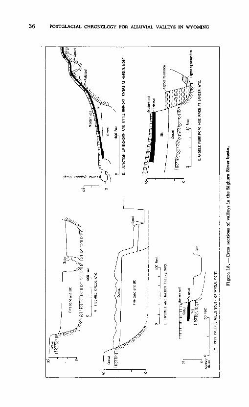
36 POSTGLACIAL CHRONOLOGY FOR ALLUVIAL VALLEYS IN WYOMING
a£0) B a
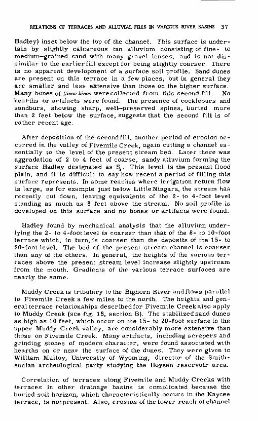
RELATIONS OF TERRACES AND ALLUVIAL FILLS IN VARIOUS RIVER BASINS 37
Hadley) inset below the top of the channel. This surface is under lain by slightly calcareous tan alluvium consisting of fine- to medium grained sand with many gravel lenses, and is not dis similar to the earlier fill except for being slightly coarser. There is no apparent development of a surface soil profile. Sand dunes are present on this terrace in a few places, but in general they are smaller and less extensive than those on the higher surface. Many bones of Bison bison were collected from this second fill. No hearths or artifacts were found. The presence of cockleburs and sandburs, showing sharp, well preserved spines, buried more than 2 feet below the surface, suggests that the second fill is of rather recent age.
After deposition of the second fill, another period of erosion oc curred in the valley of Fivemile Creek, again cutting a channel es sentially to the level of the present stream bed. Later there was aggradation of 2 to 4 feet of coarse, sandy alluvium forming the surface Hadley designated as S4 . This level is the present flood plain, and it is difficult to say how recent a period of filling this surface represents. In some reaches where irrigation return flow is large, as for example just below Little Niagara, the stream has recently cut down, leaving equivalents of the 2- to 4-foot level standing as much as 8 feet above the stream. No soil profile is developed on this surface and no bones or artifacts were found.
Hadley found by mechanical analysis that the alluvium under lying the 2- to 4-foot level is coarser than that of the 8- to 10-foot terrace which, in turn, is coarser than the deposits of the 15- to 20-foot level. The bed of the present stream channel is coarser than any of the others. In general, the heights of the various ter races above the present stream level increase slightly upstream from the mouth. Gradients of the various terrace surfaces are nearly the same.
Muddy Creek is tributary to the Bighorn River andflows parallel to Fivemile Creek a few miles to the north. The heights and gen eral terrace relationships described for Fivemile Creek also apply to Muddy Creek (see fig. 18, section B). The stabilized sand dunes as high as 10 feet, which occur on the 15- to 20-foot surface in the upper Muddy Creek valley, are considerably more extensive than those on Fivemile Creek. Many artifacts, including scrapers and grinding stones of modern character, were found associated with hearths on or ne.ar the surface of the dunes. They were given to William Mulloy, University of Wyoming, director of the Smith- sonian archeological party studying the Boysen reservoir area.
Correlation of terraces along Fivemile and Muddy Creeks with terraces in other drainage basins is complicated because the buried soil horizon, which characteristically occurs in the Kaycee terrace, is not present. Also, erosion of the lower reach of channel
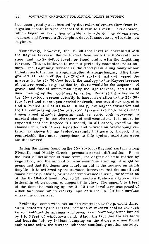
38 POSTGLACIAL CHRONOLOGY FOR ALLUVIAL VALLEYS IN WYOMING
has been greatly accelerated by diversion of return flow from ir rigation canals into the channel of Fivemile Creek. This erosion, which began in 1926, has considerably altered the downstream reaches and formed a flood plain deposit associated with this new regimen.
Tentatively, however, the 15- 20-fopt level is correlated with the Kaycee terrace, the 8- 10-foot level with the Moorcroft ter race, and the 2- 4-foot level, or flood plain, with the Lightning terrace. This is believed to make a perfectly consistent relation ship. The Lightning terrace is the flood plain along many minor tributaries to the main streams in other drainage basins. If the fine grained alluvium of the 15- 20-foot surface had overlapped the gravels on the 25- 30-foot level, the analogy to the Kaycee terrace elsewhere would be good; that is, there would be the sequence of gravel and fine alluvium making up the high terrace, and silt and sand making up the two lower terraces. Because the alluvium of the 15- 20-foot terrace actually is inset in relation to the 25- 30- foot level and rests upon eroded bedrock, one would not expect to find a buried soil at its base. Finally, the Kaycee formation and the fill comprising the 15- to 20-foot terrace are both the earliest fine grained alluvial deposits, and, as such, both represent a marked change in the character of sedimentation. It is not to be expected that the Kaycee fill should, in all cases, overflow the channel in which it was deposited and provide an overlapping re lation as shown by the typical example in figure 5. Indeed, it is remarkable that more exceptions to this typical condition were not discovered.
Dating the dunes found on the 15- 20-foot (Kaycee) surface along Fivemile and Muddy Creeks presents certain difficulties. From the lack of definition of dune form, the degree of stabilization by vegetation, and the amount of brown-surface staining, it might be presumed that the dunes are nearly as old as the terrace on which they lie. It is believed by the authors, however, that the stabilized dunes either postdate, or are contemporaneous with, the formation of the 8- 10-foot level. Figure 18, section B,shows a typical re lationship which seems to support this view. The upper 1 to 4 feet of the deposits making up the 8- 10-foot level are composed of windblown sand which clearly laps onto the 15- 20-foot surface where the dunes are.
Evidently, some wind action has continued to the present time, as is indicated by the fact that remains of modern habitation, such as old automobile springs and pans, are commonly found buried by 1 to 3 feet of windblown sand. Also, the fact that the artifacts and hearths left by Indians camping on the dunes are now found both at and below the surface indicates continuing aeolian activity.

RELATIONS OF TERRACES AND ALLUVIAL FILLS IN VARIOUS RIVER BASINS 39
LITTLE BIGHORN RIVER BASIN
The Little Bighorn River was studied in the reach from Hardin, Mont., where it enters the Bighorn River, upstream to Pass Creek near Wyola, Mont. On Pass Creek, 3 miles south of Wyola, Mont., are two prominent terraces standing 11 and 4 feet above the strccim (see fig. 18, section C). The higher surface, which is very extensive, is underlain by 4 feet of fine, gray sand. This sand is separated by a disconformity from an organic zone 3 inches thick, below which are nearly 4 feet of salmon pink silt. The upper part of the silt is strongly calichified and contains hard nodules as much as one half inch in diameter which are composed of about 65 percent calcium carbonate, the rest being mostly sand grains. Many shells of land snails OreoheHx sabradis (identification by W. J. Clench) were found in the pink zone. A few partly dis integrated bones, probablyd'sonwere also collected from this zone. On the basis of physiographic relations and the presence of the highly calichified layer, the 11-foot level is tentatively cor related with the Kaycee terrace. The 4 foot level, then, probably corresponds to the Moorcroft terrace, and the flood plain of Pass Creek with the Lightning terrace.
A-t the junction of the Little Bighorn with the Bighorn River, the larger river has impinged on a hill, the summit of which is a gravel covered terrace or pediment remnant. The cliff exposed by the river's lateral cutting provides a cross section of the ma terials deposited by the Little Bighorn River and shows their re lation to bedrock. The cross section (D) presented in figure 18 is a composite diagram based on planetable mapping and soil studies. In the lower reaches of the Little Bighorn valley the highest and most prominent alluvial terrace stands about 20 feet above the stream level. It is tentatively correlated with the Kaycee terrace on the basis of its physiographic relationship to the hills nearby, and by the fact that a paleosol typical of the sequence in other areas occurs in the deposits of this terrace. The only other terrace level found near the mouth of the Little Bighorn River is one which stands 5 to 7 feet above the stream and forms a broad flat. The authors believe that this level corresponds to the Moor- croft surface in other drainage basins. The present flood plain of the stream then would be the equivalent of the Lightning terrace.
POPO AGIE RIVER BASIN
Along the Middle Fork Popo Agie River near the eastern limits of the city of Lander, Wyo., cross section E of figure 18 was studied. There are three alluvial surfaces standing 35 to 40, 20, and 3 feet above the stream, respectively. Because of the se quence including gravel, sand and silt, paleosol, and fine allu vium, the high level is correlated with the Kaycee terrace. The
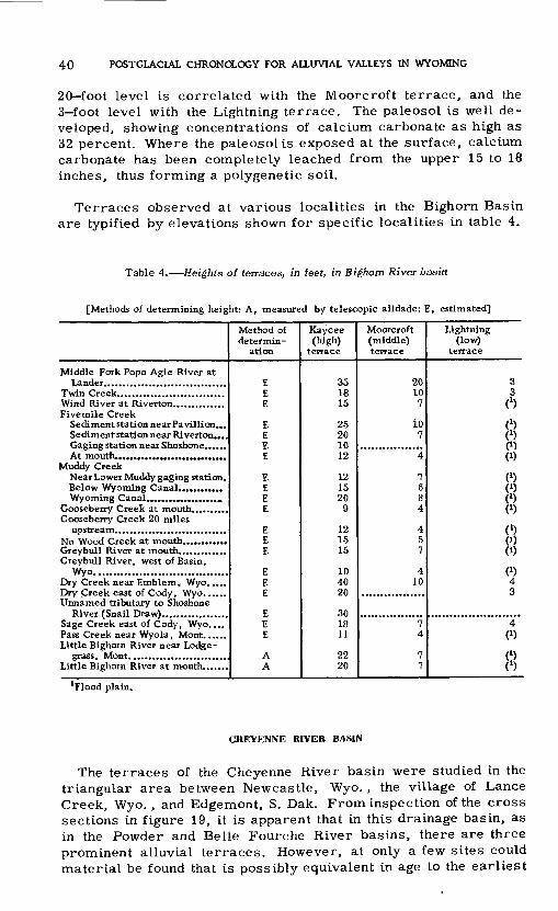
40 POSTGLACIAL CHRONOLOGY FOR ALLUVIAL VALLEYS IN WYOMING
20 foot level is correlated with the Moorcroft terrace, and the 3 foot level with the Lightning terrace. The paleosol is well de veloped, showing concentrations of calcium carbonate as high as 32 percent. Where the paleosolis exposed at the surface, calcium carbonate has been completely leached from the upper 15 to 18 inches, thus forming a polygenetic soil.
Terraces observed at various localities in the Bighorn Basin are typified by elevations shown for specific localities in table 4.
Table 4. Heights of terraces, in feet, in Bighorn River basin
[Methods of determining height: A, measured by telescopic alidade; E, estimated]
Middle Fork Popo Agie River at
Fivemile Creek Sediment station near Pavillion... Sediment station near Riverton....
Muddy Creek Near Lower Muddy gaging station.
Gooseberry Creek 20 miles
Greybull River, west of Basin, Wyo. ...................................
Dry Creek near Emblem, Wyo. ....
Unnamed tributary to Shoshone
Sage Creek east of Cody, Wyo. ... Pass Creek near Wyola, Mont. ..... Little Bighorn River near Lodge-
Little Bighorn River at mouth.......
Method of determin
ation
EEE
E E EE
E EEE
EEE
EE£
EE E
AA
Kaycee (high)
terrace
351815
25 20 1012
12 1520
9
121515
1040 20
3018 11
2220
Moorcroft (middle) terrace
2010
7
107
4
7 684
457
410
7 4
77
Lightning (low)
terrace
33
ft
(J)0C1)
(1)
O (*)
0«
(')
(1)(1)
«4 3
4 «
(t>(*)
Flood plain.
CHEYENNE RIVER BASIN
The terraces of the Cheyenne River basin were studied in the triangular area between Newcastle, Wyo., the village of Lance Creek, Wyo., and Edgemont, S. Dak. From inspection of the cross sections in figure 19, it is apparent that in this drainage basin, as in the Powder and Belle Fourche River basins, there are three prominent alluvial terraces. However, at only a few sites could material be found that is possibly equivalent in age to the earliest
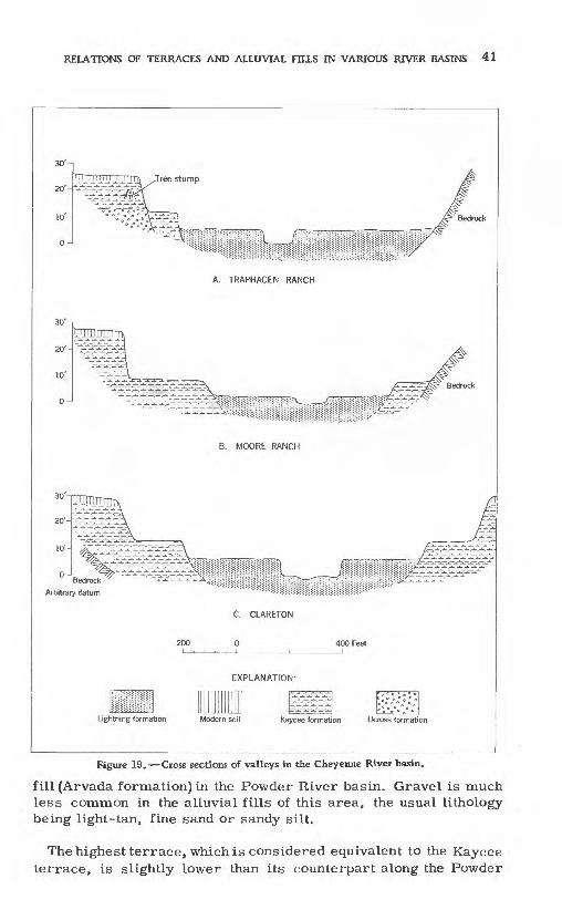
RELATIONS OF TERRACES AND ALLUVIAL FILLS IN VARIOUS RIVER BASINS 41
Tree stump
Bedrock
A. TRAPHAGEN RANCH
B. MOORE RANCH
Bedrock
Arbitrary datum
C. CLARETON
EXPLANATION
Lightning formation Modern soil Kaycee formation Ucross formation
Figure 19. Cross sections of valleys in the Cheyenne River basin.
fill (Arvada formation) in the Powder River basin. Gravel is much less common in the alluvial fills of this area, the usual lithology being light-tan, fine sand or sandy silt.
Thehighest terrace, which is considered equivalent to the Kaycee terrace, is slightly lower than its counterpart along the Powder
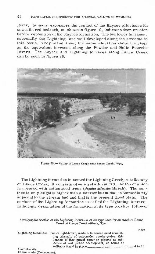
42 POSTGLACIAL CHRONOLOGY FOR ALLUVIAL VALLEYS IN WYOMING
River. In many exposures the contact of the Kaycee alluvium with unweathered bedrock, as shown in figure 19, indicates deep erosion before deposition of the Kaycee formation. The two lower terraces, especially the Lightning, are well developed along the streams in this basin. They stand about the same elevation above the river as the equivalent terraces along the Powder and Belle Fourche Rivers. The Kaycee and Lightning terraces along Lance Creek can be seen in figure 20.
Figure 20. Valley of Lance Creek near Lance Creek, Wyo.
The Lightning formation is named for Lightning Creek, a tributary of Lance Creek. It consists of an inset alluvial fill, the top of which is covered with cottonwood trees (Populus deltoides Marsh). The sur face is only slightly higher than a narrow berm that is immediately adjacent to the stream bed and that is the present flood plain. The surface of the Lightning formation is called the Lightning terrace. Lithologic description of the formation at its type locality follows:
Stratigraphic section of the Lightning formation at its type locality on reach of Lance Creek at Lance Creek village, Wyo.
Lightning formation:
Unconformity.Pierre shale (Cretaceous).
Tan or light-brown, medium to coarse sand consist ing primarily of subrounded quartz grains; thin lenses of fine gravel occur in places; no evi dence of soil profile development; no bones or artifacts found in place........................................
Feet
4 to 10
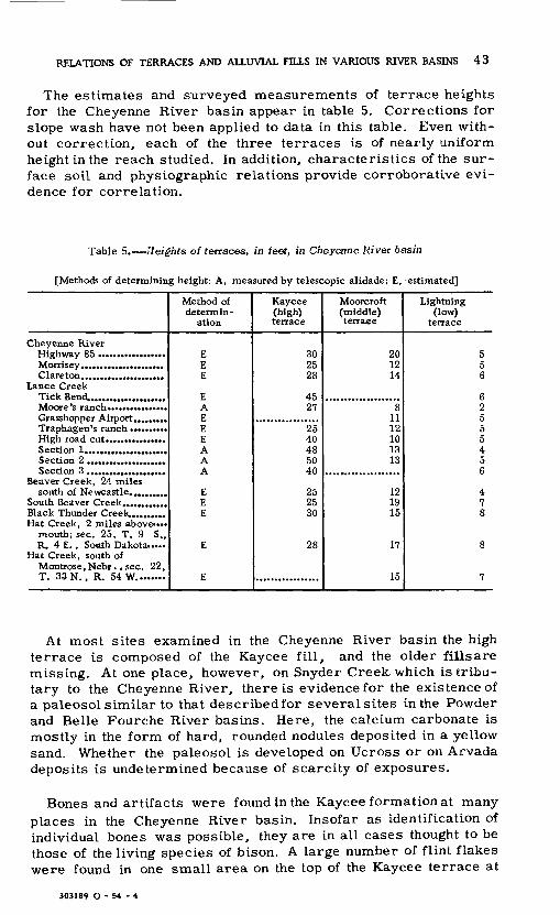
RELATIONS OF TERRACES AND ALLUVIAL FILLS IN VARIOUS RIVER BASINS 43
The estimates and surveyed measurements of terrace heights for the Cheyenne River basin appear in table 5. Corrections for slope wash have not been applied to data in this table. Even with out correction, each of the three terraces is of nearly uniform height in the reach studied. In addition, characteristics of the sur face soil and physiographic relations provide corroborative evi dence for correlation.
Table 5. Heights of terraces, in feet, in Cheyenne River basin
[Methods of determining height: A, measured by telescopic alidade; E, estimated]
Cheyenne River
Lance Creek Tick Bend.....................
Traphagen's ranch ..........
Beaver Creek, 24 miles
Black Thunder Creek..........Hat Creek, 2 miles above....
mouth; sec. 25, T. 9 S., R. 4 E. , Sooth Dakota.....
Hat Creek, south of Montrose , Nebr . , sec. 22 , T. 33 N. , R. 54 W. .......
Method of determin
ation
EEE
EAEE£
AAA
EEE
E
E
Kaycee (high) terrace
Tn2528
4597
25 40485040
252530
28
Moorcroft (middle) terrace
901214
1112 101313
121915
17
15
Lightning (low)
terrace
556
6255 5456
478
8
7
At most sites examined in the Cheyenne River basin the high terrace is composed of the Kaycee fill, and the older fills are missing. At one place, however, on Snyder Creek, which is tribu tary to the Cheyenne River, there is evidence for the existence of a paleosol similar to that describedfor severalsites in the Powder and Belle Fourche River basins. Here, the calcium carbonate is mostly in the form of hard, rounded nodules deposited in a yellow sand. Whether the paleosol is developed on Ucross or on Arvada deposits is undetermined because of scarcity of exposures.
Bones and artifacts were found in the Kaycee formation at many places in the Cheyenne River basin. Insofar as identification of individual bones was possible, they are in all cases thought to be those of the living species of bison. A large number of flint flakes were found in one small area on the top of the Kaycee terrace at
303189 O - 54 - 4

44 POSTGLACIAL CHRONOLOGY FOR ALLUVIAL VALLEYS IN WYOMING
Moore's ranch (about Smiles south of Lance Creek, Wyo.), and are of some significance. Many different kinds of flint, some clearly worked by man, are represented. No pottery was present. One flint flake was found buried in the surface soil of the Kaycee terrace and was considered in place. Chipped flakes of flint were also found on the scarp of the Kaycee terrace, but none on the lower Moorcroft terrace. This great difference in the number of artifacts on the two terraces suggests that they were worked by man on the upper terrace before the lower terrace was formed. This is the same relation noted at the artifact site on the Powder River at Arvada. None of the chipped flint artifacts are sufficiently diagnostic to be used for fixing dates, but it cart be inferred that they belonged to a prepottery culture.
NORTH PLATTE RIVER BASIN
Alluvial terraces are prominent features along the North Platte River and its tributaries. In the upper part of the valley in south- central and southeastern Wyoming, the several alluvial terraces are high enough to be easily recognized, but downstream in western and central Nebraska, terrace heights decrease and are less easily recognized. Moreover, in the wide valley the terraces are so widely separated that recognition is difficult.
Work in the North Platte River basin was of reconnaissance nature and was confined principally to the polygonal area bounded by Douglas, Sweetwater Crossing, and Laramie, all in Wyoming, and Scottsbluff, Nebr. The area covered is considerably upstream from that discussed by Lueninghoener (1947), and no correlation of the terraces of the two areas is attempted here.
From the cross sections in figure 21, it is apparent that alluvial terrace relationships in the upper North Platte River basin are similar in many respects to those described in this report for other river basins. At many places in the upper North Platte basin there are only two alluvial terraces. The information now available is, however, too limited to permit more than a tentative correlation with other areas studied. Some possible evidence for correlation of North Platte terraces with those of other rivers is found at Signal Butte near Scottsbluff, Nebr., figure 21, section M. Three well-developed terraces are present on Kiowa Creek, but on Spring Creek, a tributary of Kiowa Creek, in the vicinity of the Scottsbluff bison quarry (Barbour and Schultz, 1932; Schultz and Eiseley, 1935), there are only two terraces. In the un- weathered gravels at the base of the 15-foot terrace on Spring Creek, bones of an extinct species of bison were found by Barbour and Schultz. At the top of the silt overlying the bison zone, there is a 2- to 3-foot heavily calichified zone which possibly represents a buried soil. The top 8 feet of the terrace, consisting of fine, buff, sandy silt, with a dark humic zone at the top, contains mol- lusks which are not extinct but are found in upper Pleistocene

RELATIONS OF TERRACES AND ALLUVIAL FILLS IN VARIOUS RI\ER BASINS 45

46 POSTGLACIAL CHRONOLOGY FOR ALLUVIAL VALLEYS IN WYOMING
deposits. Tentatively, the calichified zone is considered the equiv- alentof the paleosol found in the Powder River basin, and the over lying material of the higher terrace is correlated with the Kaycee formation. If this is correct, the bison-bearing gravel might be correlated with either the Ucross or Arvada formation. Because these gravels are unweathered and show no sign of having been affected by a warm, moist period, it is supposed more likely that they are Ucross equivalents.
REGIONAL CORRELATION AND ITS PROBLEMS
Terraces observed in the valleys of several Wyoming rivers and their tributaries are strikingly similar in a number of aspects. There are generally three terraces, and in fewer sections, two. In nearly all localities where the three are present, the relative heights are similar. The highest stands above the river at about twice the height of the middle terrace, which is in turn about twice the height of the low one (see typical relations, fig. 5).
Remnants of the high terrace are composed of important amounts of slope wash, and the remnants slope upward to the adjacent hills in long, sweeping curves. The two lower terraces, in contrast, are nearly flat and slope wash appears to have contributed so little to the form of the terraces that one can characterize the materials as having been deposited entirely by the main stream.
These generalizations apply without exception to all the basins studied, which include nearly half the State of Wyoming, and it is believed that the respective terraces correlate approximately in time over the whole area. This belief is strengthened by the close analogy to similar sequences throughout a still larger region, as will be demonstrated. It becomes important, then, to examine the relationship between the sequence of river regimen indicated by the alluvial terraces of the plains, and the sequence of events in the mountains where a changing climate has left its record in gla cial and periglacial phenomena.
The argument for regional correlation will be developed in the following sequence^. First, it will be demonstrated that the highest alluvial terrace (Kaycee) has, in the mountain valleys, a correlative that appears to postdate the youngest moraine. Second, ;the climatic implication of the pedocalic paleosol will be examined, and it will be argued that the only known climatic period which would account for the physical characteristics of the paleosol and for its strati- graphic position is the Altithermal (Antevs, 1948), called in Europe the Climatic Optimum. Third, these facts will be compared with the sequences in the late Wisconsin and Recent epochs described for Texas, New Mexico, Arizona, and Nebraska.

REGIONAL CORRELATION AND ITS PROBLEMS 47
TERRACES AND GLACIAL FEATURES IN CLEAR CREEK BASIN
In Western United States, Bryan and Ray (1940), Bryan (1950), and Moss (1951), have correlated river terraces with alpine gla cial moraines in order to provide dates for archeological remains associated with the terraces. In Eastern United States, Peltier (1949) has related the terraces of the Susquehanna River to con tinental glacial stages in northern Pennsylvania and New York. Each terrace is interpreted as the surface of an outwash train de veloped during the maximum advance of a" glacial stage or sub- stage. Theoretically, then, correlation is rather simple and con sists of tracing a terrace upstream into the mountains until it ends at some terminal moraine. In practice, however, this procedure may be anything but easy, because (1) the terrace is not a con tinuous surface but, rather, occurs as dissected remnants; (2) the terrace disappears completely in narrow canyons and must be picked up again above the canyon on the basis of height, lithology, and degree of weathering; (3) the terrace may not show definite outwash relations to any terminal moraine.
The present investigation did no-t include extensive work on gla cial deposits at the headwaters of the streams studied. Terraces were traced headward along several tributaries of Clear Creek, itself a tributary to the Powder River. Clear Creek has well- defined alluvial terraces through the length of its reach on the plains. Because its headwater area in the Bighorn Mountains has been strongly glaciated, it was hoped that by tracing the alluvial terraces upstream, the alluvial chronology could be more defi nitely tied into the glacial sequence than on the basis of general argument alone.
In table 6 the terrace heights measured at various points along Clear Creek are shown. At the mouth of Clear Creek the three terraces along its valley were observed to merge into the three terraces already described along the Powder River. Table 6 shows that the heights of all three terraces above the present Clear Creek decrease in the direction of the headwaters. The character of the terraces has been described in figures 12 and 15, and these descriptions are typical for the whole reach from the mountain front to the creek mouth.
In the mouth of the mountain valley the flood plain narrows head- ward, and there is a marked change in the character of the terrace materials. One may walk from the town of Buffalo, which is built on the high, or Kaycee, terrace on both sides of Clear Creek, up stream on a continuous flat into the mountain valley.
About 3 miles east of Buffalo a drainage ditch dug in the Moor- croft terrace,*which here is more than one-quarter mile wide, ex poses an instructive stratigraphic section. Three to 5 feet of silt

48 POSTGLACIAL CHRONOLOGY FOR ALLUVIAL VALLEYS IN WYOMING
Table 6. Terrace heights, in feet, along the upper reaches of Clear Creek and NorthFork Clear Creek, Wyo.
[All terrace heights measured with hand level]
Clear Creek: Soil site, 1 mile east of
Buffalo.... ...................2. 4 miles west of Buffalo..
North Fork Clear Creek:
Above Old Lake upstream from Medicine Park......
Kaycee (high)
terrace
2012 12
810
810
78
108
3
Moorcroft (middle) terrace
124 45644
43
Lightning (low)
terrace
52 12212
11
Miles upstream from mouth of Sand
Creek near Buffalo
2.4 3.74.65.86.3
12.1
13.318.225.226.2
27.3'
and sand containing gravel lenses overlies disconformably a poorly sorted gravel ranging in size from sand to rounded boulders a foot in diameter. The gravel is generally stained a yellowish color. The upper surface of the gravel is markedly undulating. At the edge of the Moorcroft terrace the gravel can be traced under the Kaycee terrace. That the Moorcroft terrace is here cut on ma terial of Kaycee age and older is well demonstrated. The gravel underlying Kaycee formation must represent a relation similar to that shown in figures 14 and 15, and is considered Ucross in age.
At Buffalo, the Kaycee terrace is predominantly silt, at least in the upper few feet, as indicated in figure 15. The present stream- bed is covered with gravel, probably a thin veneer only. A mile upstream from Buffalo, where the width of the Kaycee terrace is about one-quarter mile, a long, deep trench excavated for a pipe line provided a good temporary exposure for study. In the trench 2 to 3 feet of fine sand was interspersed with lenses of sand and clay,underlain by gravel. At Fort McKinney, only a mile farther upstream, the Kaycee terrace decreases in width to about 100 yards, and is composed of coarse gravel, including some sub- rounded boulders as much as 1 foot in diameter. At that point, two distinct surfaces stand at levels lower than the Kaycee terrace, which is there 12 feet above the stream. Farther upstream the terraces, where present, are generally gravel. This transition in texture from silt to gravel near the mountain front takes place without any break in the topographic continuity of the Kaycee ter race. Whether these relationships are attributable to wedging out of the silty Kaycee formation could not be determined from the exposures available.

REGIONAL CORRELATION AND ITS PROBLEMS 49
In the narrow canyon the terraces are present only as rem nants, and correlation must be based primarily on height above the stream and physiographic position relative to other terraces, because there are no significant differences inlithology and weath ering on the various terraces. Adding to the difficulty of corre lation, the terraces themselves are quite low.
Glacial deposits are extremely well developed along Clear Creek. Above an altitude of 8, 000 feet (about 20 miles upstream from Buffalo) typical glacial forms, including both terminal and lateral moraines, kettles, ponds and lakes, are very well pre served. Boulders are strewn over the surface and there is little evidence of soil development or weathering. There are two sets of we 11-developed lateral moraines; a clearly defined terminal moraine is associated with the more extensive and older of the two laterals. The older, or higher, lateral moraine rises about 500 feet above North Fork Clear Creek, and the younger, or lower, one stands about 150 feet above the creek.
Just below Florence Lake near the headwater divide, at alti tudes of 10, 300 to 11,000 feet (28 miles upstream from Buffalo) there are striking deposits of large, angular rock rubble forming short ridges which rise 100 to 200 feet above the floor of the val ley. These are protalus ramparts of the type described by Bryan (1934). Those described by Bryan occur in cirques and form a barrier trending normal to the valley. The features in the valley of North Fork Clear Creek are composed of blocks frost-riven off the cliffs bordering the narrow valley, and for this reason the ramparts are essentially parallel to the valley axis.
Individual, boulders in the ramparts are as much as 40 feet in the largest dimension, and many of them measure in tens of feet. They are fresh in appearance, without lichen coverings, but are somewhat darker than the modern talus slopes behind the ram parts. The modern talus is characteristically composed of un- weathered angular blocks less than one-fourth the size of those in the ramparts.
The relative position of the Kaycee terrace with respect to the glacial sequence of Clear Creek will now be discussed. Table 6 contains datafrom 12 localities along Clear Creek and North Fork Clear Creek at which terrace heights were estimated. The 12 points are designated according to their distance upstream from Buffalo. The third locality, Fort McKinney, represents the change from the silty surface of the Kaycee terrace, characteristic of the plains, to the gravel surface of the mountain valley. The Clear Creek localities are arranged in order upstream toward the head water. The height of the Clear Creek terraces decreases more or less continuously upstream, becoming roughly half as high in the headwaters as at Buffalo. Terrace remnants occur far up-
50 POSTGLACIAL CHRONOLOGY FOR ALLUVIAL VALLEYS IN WYOMING
stream from the youngest terminal moraine seen in the valley, but disappear downstream from the protalus ramparts. The whole length of valley train deposits within the moraine have been sub ject to surface reworking, at least near the stream.
It will be understood that the remnants of terraces are poorly preserved in the mountain valley, and absent in the narrow, steep canyon sections. Each of the measured sections presented in table 6, however, represents clearly developed terrace flats with distinct risers. The problem of interpretation is less concerned with the existence of terrace remnants, which in the field seemed valid, than with the correlation of the remnants. In table 6 assignment of the observed remnants to the columns designating age Kaycee, Moorcroft, and Lightning is based entirely on the height of the remnants above the stream. This assignment derives its primary support from the relatively close accordance in height and the more or less progressive decrease of height upstream.
By such correlation, the highest terrace in the mountain valley is equivalent to the Kaycee terrace downstream. Because there are remnants of this terrace upstream from the youngest moraine, the Kaycee terrace must postdate the latest phase of glaciation in this valley.
Study of two drainage basins adjacent to North Fork Clear Creek French Creek and South Piney Creek showed consider able difference in the glacial features. Detailed description of these features is considered inappropriate for inclusion in this report.
Because of the differences in the valleys studied, the authors believe that correlation of moraines in the Bighorn Mountains with the glacial sequence of Bryan (1950) and others would be unwar ranted in the present state of knowledge. Yet, the existence of evidence indicating that the Kaycee terrace postdates the youngest moraine is important to an under standing of the alluvial sequence.
CLIMATIC IMPLICATIONS OF THE PALEOSOL
Any series of events proposed to explain the terrace sequence and related features must include a period of soil development after the deposition of the Ucross formation and before that of the Kaycee formation.
Modern surface pedocalic soils are widely distributed geograph ically and occur in several distinctly different climatic environ ments. They are commonly characterized by a zone leached of soluble salts in the upper part of the profile and concentration of these salts, especially calcium carbonate, in a lower layer.

REGIONAL CORRELATION AND ITS PROBLEMS 51
Nikiforoff (1936, 1937) has questioned the pedologic character of calcium carbonate accumulations on the grounds that many soils that show this feature are derived from lime-rich parent materials; however, it is generally agreed (see Robinson, 1949) that soil- forming processes are involved. The depth of the zone of accum ulation is related to the amount of precipitation; a greater depth of the zone is associated with high precipitation, and the zone of accumulation is nearer the surface under more arid conditions. Furthermore, the largest accumulation of calcium carbonate in soils seems to be associated with conditions of aridity. So far as the clay complex of pedocal soils is concerned, there would appear to be no vertical differentiation due to eluviation and illuviation.
Bryanand Albritton (1943) consider apedocal-type soil, whether modern or ancient, to be associated with climatic conditions con siderably more arid than those under which pedalfer-type soils (in which aluminum and iron are concentrated in the B layer) are developed. They point out that climate is one of the most important factors in soil formation and that, therefore, a change from a relatively arid to a relatively humid climate would cause a change in the type of soil produced.
The conspicuous pedocalic paleosol, characterized by a high concentration of calcium carbonate, has been described in this report at several localities. Were one to rely entirely on the mere presence of the calcium carbonate zone, it might be questionable whether this zone should be considered of pedologic origin, owing to the fact that in no place was a well-defined A horizon of an ancient soil found. However, the calcium carbonate zone can be traced continuously along buried erosion surfaces which cut across several lithic types, as shown in figure 16, a circumstance which argues strongly for a pedologic origin. The calcium carbonate zone is in some places exposed at the surface, and wherever it is, the surface part of the zone is apparently being leached under the present climatic regime.
If paleosols are to be interpreted as indicators of periods of subaerial weathering, it is the contention of the authors that there should be present definite characteristics of profile development. Dark bands in alluvial deposits exposed along raw banks of arroyos may be mistaken for buried soils. In many places, the dark bands, often interpreted as buried carbonaceous A horizons, are merely due to textural differences which cause a band of fine-grained ma terial to retain moisture, and hence appear darker in color. Chem ical analysis of the dark bands may show no organic matter to be present. Unless a particular band shows evidence of profile devel opment that is, horizons of leaching and accumulation no partic ular stratigraphic significance could be attributed to such a zone nor could the zone be considered to represent any appreciable

52 POSTGLACIAL CHRONOLOGY FOR ALLUVIAL VALLEYS IN WYOMING
period of time during which sedimentation ceased and weathering occurred.
In identifying zones of illuviation, it was noted during this in vestigation that accurate field estimation of amounts of calcium carbonate in a soil is very difficult. The authors have not had great experience in such matters, but visual estimates of relative amounts, whether large or small, often proved wrong, and even the use of an acid bottle in the field did not completely eliminate this difficulty. Therefore, the soils and paleosols were sampled and analyzed for calcium carbonate in the laboratory by a volumetric technique depending on liberation of carbon dioxide gas by addition of hydrochloric acid. Such an analysis took about 5 minutes a sample, and gave results reproducible to within 5 percent. The difficulty with estimating relative amounts of calcium carbonate in the field, even using an acid, is that the carbonate may be well distributed in a particular part of the soil profile, or it may be concentrated in nodules, concretions, fibrous threads, and irreg ular soft masses. Furthermore, in many places the white material at first thought to be calcium carbonate was shown actually to in clude considerable amounts of gypsum.
Another difficulty in the interpretation of buried pedocalic soils is the effect of texture. It was noted in many places that the con centration of calcium carbonate in a layer of fine silt or clay was much greater than in an overlying or underlying layer of coarser material. Such concentrations of calcium carbonate might easily be mistaken for significant profile zones.
It may be argued that the position of the ground-water table was the critical factor in producing the carbonate soils and crusts described. Certainly where carbonate-rich zones are concentrated in noncalcareous materials, it must be concluded that those areas were under the control of ground water. Also, it might be argued that these carbonate zones are being produced under present ground- water conditions. It can be conclusively shown that at Sussex, Buffalo, Ucross, and other places, the present water table is far below the zone of carbonate concentrations. Furthermore, X-ray analysis showed the most weathered mica in the stratum where the carbonate accumulation was greatest.
Field examination and laboratory data prove the existence of a carbonate-rich zone buried beneath the surface of the Kaycee ter race in many localities. This zone is interpreted as pedogenic, despite the fact that no example of a well-defined A horizon has been discovered. Under arid conditions, it seems likely that a carbonate zone could develop essentially at the surface of the ground.
REGIONAL CORRELATION AND ITS PROBLEMS 53
It seems necessary, then, to postulate a period of aridity later than the deposition of the Ucross formation and before deposition of the Kaycee silt, during which the carbonate-rich zone was developed.
High gravel-capped surfaces are present in many of the areas studied, but, are not within the scope of this report. These surfaces, older than the alluvial terraces, characteristically have thick- surface crusts of calcium carbonate, which may have developed in part or wholly during the period when the carbonate zone buried beneath alluvium was formed (see fig. 16).
THE CHRONOLOGY OF CLIMATIC EVENTS
A sequence of events which appears to explain the observed facts in Clear Creek valley and in the other streams of the area will now be postulated.
In late Wisconsin time, glaciers advanced in places in the Rocky Mountains. In the Bighorn Range at least two such advances can be recognized by moraines. During the earlier of these, large volumes of gravel were carried by the streams emanating from glaciers out into the valleys of the plains where they were in part deposited. The recession from the terminal moraine at an altitude of 8, 000 feet was reversed by another advance somewhat less strong. More gravel was carried out into the river valleys of the plains, but present exposures do not allow a determination of any differences in the gravel deposits of these two glacial advances. The gravels of the Ucross formation are considered to be related in age to one or both of the glacial advances indicated by these moraines.
During the glacial period, sedimentary rocks of the plains were eroded, and possibly this erosion was accelerated by frost proc esses; however, the silt derived from the plains could easily have been carried by sti earns which were fed by glacial melt water and were capable of transporting gravel. For this reason the fine material tended to be carried far downstream and the coarser gravels were deposited to form the Ucross formation.
During the glacial retreat, the production of gravel by ice abra sion decreased, and the melt waters of the waning ice reworked the ground moraine and the valley gravel deposits, eroding some of the deposited gravel and carrying it away. When the ice had mostly melted under the ameliorated climate, the melt water be came a relatively unimportant source of water in the plains streams. It is postulated that the trend toward aridity increased the importance of summer rainstorms as an agent of erosion on

54 POSTGLACIAL CHRONOLOGY FOR ALLUVIAL VALLEYS IN WYOMING
the plains, for the Bermuda anticyclone moved northward and in summer brought Gulf air into the Middle West much as it does at the present time. A condition even more continental than the present climate of the area had been reached as the Altithermal time approached. Such a climate increased the importance of an anti cyclone over the Rocky Mountain area in winter, which gave rise to frequent storm passages and accompanying wind, but without high precipitation owing to .the lack of development of deep cyclones. Such a winter situation is typical of a high-index-pressure pattern; that is, one in which there is a large difference in pressure from midlatitudes to northerly latitudes.
Summer in the Altithermal time was marked by low pressure over the continent, with a strong anticyclonic flow of air aloft around the upper air extension of the Bermuda high-pressure cell. As at present in the Southwest, considerable moisture derived from the Gulf of Mexico passed over the desert aloft, but the dearth of strong wave -troughs aloft precluded the precipitation of that moisture except as infrequent but intense thunderstorms. Under such a climate, flash floods punctuating the hot, dry summers of the plains provided a period characterized by erosion of the valleys in the plains, but in the form of gullying rather than extensive sheet erosion Chemical weathering of the sediments making up the plains was not intense, and the flash floods trenched the valleys but did not preclude the development of an arid-type soil on the uplands. The gravel of the Ucross formation was, therefore, eroded from the valleys except in isolated patches, and on these areas paleosol developed.
It is postulated that Altithermal time was characterized by an increase in the zonal index;*that is, rapidly moving,and frequent but weak cyclones in winter and a decrease in the meridional exchange of air. This is the concept held by Willett (1949). Such a condition would lead to frequent periods of wind during the passage of weak fronts. A high-index-circulation pattern is associated with intensification of the major anticyclones, and it is agreed by most workers that during a period of interglacial climate, the permanent high-pressure cells move northward somewhat and expand as well as intensify. Such a situation is envisaged as implying a geographic expansion of the summer synoptic pattern of New Mexico and Arizona in which Gulf moisture aloft is carried northward and thence eastward in the anticyclonic flow of high levels. During the in frequent pas sages of low-pressure troughs aloft, strong eonvective thunderstorms can break out over a wide area.
It need not be assumed that during Altithermal time the semiarid and desert areas experienced a large reduction in the present low annual rainfall. Rather, the Altithermal is visualized as a time of
'Mean pressure gradient between two chosen latitudes, usually 35° N. and 50° N.

REGIONAL CORRELATION AND ITS PROBLEMS 55
slight intensification of the conditions which characterized the period 1850 70 in New Mexico in which there was a significant deficiency in the number of small rains as compared with large rains (Leopold, 1951a). Leopold demonstrated that the differential change in frequency of large and small rains has characterized the present climatic fluctuation in New Mexico without a significant change in annual rainfall. He argued that the reduction in frequency of small rains, which are important in supporting the vegetal cover, and a concomitant increase or lack of decrease of great rains, promote gully erosion and the degradation of alluvial valleys.
This conception of the Altithermal in the West would account for the general degradation of valley alluvium, the observed efficacy of wind action, and the development of an arid-type soil profile over large areas adjacent to the Rocky Mountains.
Altithermal time gave way to a period of climate somewhat more cold and wet than the present, but only intense enough to cause patches of ice to accumulate in the highest mountain valleys. The alternation of snow and no snow, typical of present winters but slightly intensified, was accompanied by frost action in the moun tains and probably to a lesser extent on the plains. The same change caused a summer climate more typical of the Middle Western than of the Southwestern States, with a decrease in the importance of flash storms. Thus, winter conditions were conducive to rapid disintegration of the rocks of the plains and the production of large amounts of silt and fine sand, but there was insuf fie ient flood volume from the mountain streams or from summer storms to carry the silt away. The fine-grained materials then accumulated in the valleys and Kaycee deposition was in progress. It was mostly during such a cold period that the protalus ramparts were formed in the mountains.
This post-Altithermal period was marked by two minor fluctua tions in climate during Moorcroft and Lightning time. The mecha nism of shift was comparable in character, but not in intensity, to that which caused the change from the last glacial stage to the Altithermal.
These climatic shifts were of a type which must perforce have affected wide areas. The climatic mechanism necessary for the various shifts in one locality lay in the general atmospheric cir culation whose effects were regional.
Some idea of the minimum area which would be affected in a similar way by a shift of climate may be gained by study of the recent climatic variation for which meteorologic records are available.

56 POSTGLACIAL CHRONOLOGY FOR ALLUVIAL VALLEYS IN WYOMING
Utilizing the Daily Synoptic Map Series of the U. S. Weather Bureau covering the period 1899 1939, Petterssen (1949) studied changes in certain indices of the general circulation and compared winter conditions of the first and second halves of the period. A major temperature rise, particularly in northern latitudes, has characterized the second half of the 40-year period. Some of his conclusions may be summarized as follows:
1. There has been an intensification of the meridional and a reduction in the zonal circulation. 2. Over Europe and the Bay of Biscay there has been a fairly uniform decrease in the number of cyclone centers, with particularly marked decrease over Scandi navia and the Norwegian sea. At the same time, cyclonic activity has increased substantially over the Mediterranean and the Balkan areas, and also over an area south and east of Newfoundland north ward to Greenland.
No cursory discussion can replace actual inspection of Lysgaard' s (1949) anomaly maps for the world, presenting summary informa tion on geographic distribution of changes in weather elements between 1910 and 1940. In discussing these summary maps of temperature variation, Lysgaard says:
The great (January) temperature rises (1910 1940) of more than 3° [C] has taken place in Greenland, but Spitzbergen, North Asia and the northern part of North America can also show appreciable rises of more than 2°. ***The most extensive [temperature] fall appears to faave taken place in East Asia and Australia.
The greatest temperature rise [for July] which is more than 1° [C], has taken place in Finland, North Scandinavia and central parts of Canada and the United States. ***The most extensive fall has occurred in Central Asia and the Monsoon district of South Asia. (P- 33)
Discussing similar charts of precipitation change in the 1910 40 period, Lysgaard says, in January, the precipitation has increased
***over the greatest part of Algiers, Tunis, North America and Indonesia, while***de- creasing in Greenland, Spain, Portugal, West Africa and the Nile.
In July the variation has been positive in the areas around the North Sea, at the Gulf of ?<lexico, in South America, South Africa and South East Asia, while it has been nega tive in most of Europe, the United States [and] West Africa. ***(p. 49).
These climate variations in a 30-year period provide some per spective of the areas of positive and negative anomalies. It need not be supposed that variations in climate begin and end simultane ously over large geographic areas. It appears that a lag in the effects of recent fluctuations was of such a nature that it caused the anomalies to spread geographically in a consistent pattern.
Schove (1950) presents evidence which indicates that between 1880 and 1915 a zonal ring of high pressure moved progressively from the Arctic Arch to the Tropic of Cancer. Preceding and following this ring were rings of high rainfall, low pressure, and
REGIONAL CORRELATION AND ITS PROBLEMS 57
high temperature-gradient, suggesting that at any given latitude, five phases progressively occur in sequence during a period of climatic shift.
Maps showing progressive averages of annual runoff prepared by Hoyt (1936) and later by Harbeck and Langbein (1949) indicate decreasing runoff for the period of streamflow records (about 50 years) in the United States. Deer easing runoff was concurrent with the generally increasing temperatures. These studies indicate that, with many local exceptions, runoff trends tend to be generally similar for an area as large as half the United States.
Studies of the present climatic fluctuation indicate an order of magnitude of the area over which*similar direction of change is probable. Faegri (1950) states as a principle that "the shorter the duration of a climatic fluctuation, the smaller is the area similarly affected; the longer the cycle, the greater the area within which it is felt in the same way. "
It appears, therefore, that an area as large as four or six Western States is of the minimum order of magnitude which might be expected to react similarly in a given climatic fluctuation. Where the boundary of such auniformily affected area might be is another question. Also, the effects of altitude might make changes in the mountains somewhat different from those of the plains.
A general argument based on meteorologic evidence makes it seem probable that streams in the Rocky Mountain area should have experienced generally similar sequences of alluviation and degradation under the influences of a varying climate. Even if a general similarity exists over a region, the same meteorologic considerations allow a measure of variability, even within short geographic distances.
The major part of a late glacial and Recent regional correlation has already been worked out by Bryanin a number of papers (1941^. 1950, and others). These are summarized with a few additions in table 7. The sequence postulated in the present report is tentative, but it appears to fit well into that developed for the Southwest, as can be seen in the table. In nearly all instances the climatic sequence derived from studies of alluvial terraces has been worked out for the purpose of dating a particular archeological site. In the present study, reconnaissance methods were applied to several adjacent major stream systems and, therefore, a somewhat larger area was studied than in previous similar investigations.
Reference to table 7 shows that the Jeddito formation (Hack, 1942), which is correlated with the Ucross formation of the present report, is characterized in all localities by a relatively large pro portion of gravel, cementation of gravel by carbonate, and by the

58 POSTGLACIAL CHRONOLOGY FOR ALLUVIAL VALLEYS IN WYOMING
Table 7. Regional correlation
Alluvial chronology (Bryan,1941)
Modern erosion.
Deposition 3.
Erosion.
Deposition 2b.
Erosion.
Deposition 2a.
Erosion.
Deposition 1.
Glacial chronology
Post- Altithermal.
Altithermal
Late Wisconsin (substage unknown).
Wyoming ^Leopold
and Miller)
Modern erosion.
Lightning deposi - tion.
Erosion.
Moorcroft deposi tion or stability.
Erosion.
Kaycee deposi tion; modern fauna.
Erosion; well- devel- oped paleosol.
Ucross gravel.
White water Draw, Ariz.
(Savles and ^ntevs,1941J
Modern arroyo.
Upper silts; pottery after A. D. 1300.
Erosion after A. D. 1200.
i
San Pedro deposition; radiocarbon age of 2,500 years.
Erosion.
Chiricahua stage; modern fauna; radiocarbon age of4,OOC years.
Erosion
Sulphur Springs stage; Ele phant , Equus, Camelops, hickory; radiocarbon age of 78- 7200 years.
Hhaco Canyon , N. M.
(Byran, 1941)
Modern erosion.
Channel deposit; pot tery circa A. D. 1200.
Erosion.
Main fill; pot tery dated A. D. 500- 700
Large arroyo.
San Jon site, N. M.
(Judson, 1953)
Modern dunes and channel cutting.
Wheatland formation; after circa A. D. 1400.
Channel cut ting on streams; de flation of some depres sions; circa A. D.13- 1400.
Upper Sand Canyon for mation; in part later than A. D. 1.
Channel cut- ting; wind action.
Lower Sand Canyon for mation; "Collateral Yum a" pro jectile point.
Channel cut ting; sand dunes; defla tion of de pressions.
San Jon forma tion; San Jon, Folson (?), Plainview (?) projectile points; extinct fauna.
Grants, N. M. (Bryan and
VfcCann, 1943)
Modern arroyo; dunes.
Upper part of '"Late Alluvi um."
Erosion; late dunes; pottery.
Late Alluvium,"
San Jose complex; pottery.
"Old Dunes"; broad arroyo.
"Intermediate Alluvium."1
Following Judson's rearrangement. 2Along eastern margin of plains.

REGIONAL CORRELATION AND ITS PROBLEMS 59
of alluvial terrace sequence
. Gallup, N. M. (Leopold and
Snyder, 1951)
Modern arroyo.
Late fill in channels.
Erosion.
Upper Nakaibito for mation; pottery dated A. D. 900-1100.
Erosion.
Lower Nakaibito forma tion.
Erosion; paleosol.
Gamerco formation.
Hopi country, Ariz.
(Hack. 1942)
Modern dimes and channel cutting.
Naha forma tion; after A. D. 1300.
Erosion and possibly some wind action; after A. D. 1200, before A. D. 1500.
Tsegi forma tion (B).
Possible erosion.
Tsegi forma tion (A).
Channel cut* ting and dunes.
Jeddito forma tion; probos cidian.
Big Bend area, Tex. (AlbrittonandBryan, 1939. and Kelley, Campbell, anc
Lehmer, 1941)
Modern channel cutting.
Kokernot formation.
Channel cutting.
Upper Calamity formation.
Erosion (?).
Lower Calamity formation.
Wind action; broad channels.
Neville formation;£/ep/ias and IT guns.
High Plains area, Tex. (Huffington and
Albritton, 1941, and Evans and Meade, 19451)
Modern channel cutting;2 Monahans formation (upper part) .
Low terrace and recent fill.
Channel cutting;2 Monahans formation (main body).
Intermediate terrace and Recent fill.
Channel cutting;2 Judkins formation.
High terrace; 2 late Pleisto- fill and Tahoka clay; Plainview projectile point; extinct fauna.
303189 O - 54 - 5

60 POSTGLACIAL CHRONOLOGY FOR ALLUVIAL VALLEYS IN WYOMING
inclusion of an extinct fauna and a stone culture (prepottery). This deposition was followed by a period of wind action, erosion, and soil formation during Altithermal time.
The second depositional phase, or phase 2a of Bryan (1941), appears to correspond to the Kaycee deposition in valleys in a very large area in Wyoming. It is characterized by a generally silty or sandy fill, annodern soil, lack of the strong calcification imposed on the top of the earlier Deposition 1, by the absence of extinct fauna, and by the inclusion of a prepottery culture.
The erosion at the end of this deposition was less marked in most areas than that following Deposition 1. Wind action accom panied this erosion in some places.
The third phase (2b of Bryan, 1941) may be represented by a period of downcutting only, as indicated by the Moorcroft terrace in Wyoming, or it maybe a fill terrace which it appears to be in eastern New Mexico (Judson, 1953), on the Puerco River, New Mexico (Leopold and Snyder, 1951), in the Hopi country (Hack, 1942), and in the Big Bend area of Texas (Albritton and Bryan, 1939). This time unit to which the Moorcroft in Wyoming appar ently belongs is characterized by practically no soil development, a modern fauna, a pottery culture at least in the upper part of the alluvial fill, including pottery types of the Christian era and prob ably as late as A. D. 1200. It was followed by a period of erosion of variable magnitude.
The last phase appears everywhere to represent an alluvial fill, the deposition of which began between A. D. 1200 and 1500. Dep osition was interrupted by the erosion period which began about 1880 and was at least partly a result of land use by man. The Lightning formation is believed to relate to this phase.
PALEOHYDROLOGY
Consideration of the alluvial chronology brings to mind a host of questions concerning a comparison of the present with conditions which prevailed in the past. These questions are concerned not so much with past climate itself, but with the interaction of climate, vegetation, stream regimen and runoff which obtained under cli mates different from that of the present. That is, with hydrologic rather than merely climatic factors. To describe this general subject the word "paleohydrology" is introduced.
Two lines of evidence will be explored in the discussion. The first concerns the gradients of present and past channels of the Powder River and one of its tributaries, Clear Creek. The second
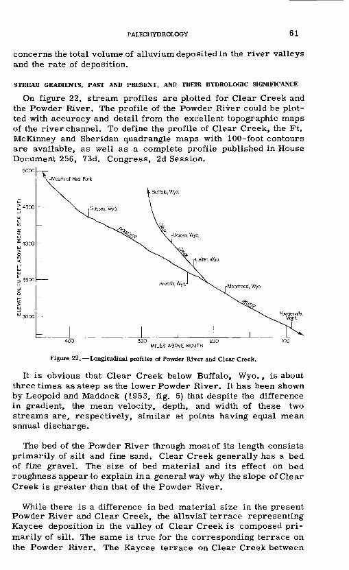
PALEOHYDRQLOGY 6 1
concerns the total volume of alluvium deposited in the river valleys and the rate of deposition.
STREAM GRADIENTS, PAST AND PRESENT, AND THEIR HYDROLOGIC SIGNIFICANCE
On figure 22, stream profiles are plotted for Clear Creek and the Powder River. The profile of the Powder River could be plot ted with accuracy and detail from the excellent topographic maps of the river channel. To define the profile of Clear Creek, the Ft. McKinney and Sheridan quadrangle maps with 100 -foot contours are available, as well as a complete profile published in House Document 256, 73d. Congress, 2d Session.
alo, Wyo,
\ \> 4500
3000
300 200 MILES ABOVE MOUTH
Figure 22. Longitudinal profiles of Powder River and Clear Creek.
It is obvious that Clear Creek below Buffalo, Wyo., is about three times as steep as the lower Powder River. It has been shown by Leopold and Maddock (1953, fig. 5) that despite the difference in gradient, the mean velocity, depth, and width of these two streams are, respectively, similar at points having equal mean annual discharge.
The bed of the Powder River through most of its length consists primarily of silt and fine sand. Clear Creek generally has a bed of fine gravel. The size of bed material and its effect on bed roughness appear to explain in a general way why the slope of Clear Creek is greater than that of the Powder River.
While there is a difference in bed material size in the present Powder River and Clear Creek, the alluvial terrace representing Kaycee deposition in the valley of Clear Creek is composed pri marily of silt. The same is true for the corresponding terrace on the Powder River. The Kaycee terrace on Clear Creek between

62 POSTGLACIAL CHRONOLOGY FOR ALLUVIAL VALLEYS IN WYOMING
the towns of Ucross and Leiter slopes 16 feet per mile, as com pared with the present stream gradient of 16.4 feet per mile. The Kaycee terrace of the Powder River between Sussex and Arvada falls 5. 4 feet per mile, compared with the present stream gradient of 5. 5 feet per mile. In other words, Clear Creek deposited in Kaycee time the same size of material as the Powder River but at a much higher gradient, and both streams have gradients at present only slightly different from their respective gradients in Kaycee time.
Now it might be supposed that during a period of widespread alluviation in a river flowing on a bed composed of its own trans ported sediment and in a self-formed channel, there would be ample opportunity for the longitudinal profile to be adjusted to conform to the size of the material being carried. If this were so, the present Clear Creek, whose bed consists of fine gravel, should be far steeper than its channel formed at the end of Kaycee dep osition when the stream flowed on an alluvial fill composed pri marily of silt. Yet, the gradient of the surface of the silty terrace is nearly identical with the gradient of the present stream. It is necessary to suppose that when Clear Creek filled its valley with tens of feet of silt nearly devoid of gravel it must have had a channel bed composed primarily of silt in contrast to the gravel bed ob served in the stream today.
Further, it might be expected that for a given discharge, the gradient «of the Powder River in Kaycee time was nearly equal to that of Clear Creek of Kaycee time because both were carrying and depositing nearly the same size of material; however, the Kaycee terrace along the Powder River slopes much less steeply than the comparable terrace on Clear Creek.
An attempt will be made to account for these apparently anomalous facts. Valid comparisons of the gradients of two streams maybe made only when the effect of discharge is considered. It is recog nized that slopes of rivers are less steep for rivers of large than for those of small discharges, sediment sizes remaining the same. It will be argued here that in Kaycee time Clear Creek must have discharged a much smaller amount of water relative to the dis charge of the Powder River than it does today. From this relation it would follow that the mountain contribution of water was much lower relative to the plains contribution during Kaycee time than is observed today. The reasoning supporting this conclusion will now be developed.
At a given stage in the physiographic history of a river, the elevation of its mouth is essentially fixed by the master stream or other base level to which the stream is graded. Also, the elevation of the uppermost watershed divide is fixed. That is, the difference in elevation between mouth and headwaters is the result

PALEOHYDROLOGY 63
of physiographic history. Between these elevations the stream might be considered as adjusting its profile. In the case of the Powder River, physiographic events determined that its mouth should be a long distance from its headwaters, and for this reason the mean gradient is relatively small. In the case of Clear Creek, the difference in elevation from mouth to watershed divide is con siderable, and the distance relatively short. Its overall slope must, perforce, have been steeper than that of the Powder River.
Physiographic history before Kaycee time had seen particular profiles developed on the two streams. The Powder River profile was characterized by a very long reach of nearly uniform, gentle slope. Clear Creek was characterized by a somewhat steeper, more concave profile. With these profile conditions existing at the beginning of Kaycee time, both streams received an increase of sediment of silt size from the plains area, and both began to aggrade.
Consider now a point on the Powder River at which the mean annual discharge is at present equal to 200 cfs. This point lies between the towns of Sussex and Arvada, Wyo. Between these towns the Powder River slope is nearly uniform, and has a value of 5. 5 feet per mile.
Now consider a point on Clear Creek where the present mean discharge is also 200 cfs. This point is somewhere below Ucross but upstream from Leiter. In this reach the slope of Clear Creek is 16.4 feet per mile.
It has already been stated that the shape factors for Clear Creek and the Powder River are nearly identical for the same discharge at the present time. Moreover, for the same discharge Clear Creek probably now carries a smaller total sediment load than does the Powder River.
Therefore, quasi-equilibrium at points of equal discharge but different slopes is maintained at present by the different size of bed material and not by channel shape. In fact, the larger size of bed material in Clear Creek requires a greater slope despite the fact that the total load in Clear Creek is not so large as in the Powder River for a given discharge. Caliber of load probably overcompen- sates for the smaller total load.
It follows, then, that if in Kaycee time the streams at the two points being considered carried sediment of equal size, the differ ential in gradient must have been compensated by one or more of the following: (1) flattening of slope on Clear Creek; (2) adjustment of the channel section of Clear Creek to a wider and more shallow stream than at present; and (3) a decrease in discharge in Clear Creek relative to that of the Powder River.

64 POSTGLACIAL CHRONOLOGY FOR ALLUVIAL VALLEYS IN WYOMING
With regard to slope adjustment, the gradient of Clear Creek in Kaycee time was about 16 feet per mile, or 0. 4 foot per mile less than its present gradient, based on the change in height of the Kaycee terrace scarps between Leiter and Ucross. The gradient of the Powder River in Kaycee time was about 5. 4 feet per mile, or 0.1 foot per mile steeper than its present grade, based on the change in height of the Kaycee scarps between the towns of Arvada and Sussex. Apparently, the slope-adjustment differential between the two streams totaled about 0. 5 foot per mile, but the actual gradients still were in the ratio 5.4:16, or 1:3. Thus, it appears that the slight adjustment in slope was minor compared with the overall difference in gradient of the two streams carrying sediment of the same size.
Concerning the second possibility, adjustment of channel section, the present shape factors seem to be determined primarily by the bank materials which are silt in both streams. Because the ma terials carried by the streams were more nearly alike in Kaycee time than at present, there is no reason to expect a great differ ential adjustment in channel shape in Kaycee time.
The foregoing argument then leads to the third possibility, that the discharge of Clear Creek must have decreased relative to that of the'Powder River when comparison is made between two points equal in discharge at the present time. A postulated differential decrease in discharge of Clear Creek would be in the direction necessary to establish equilibrium with the smaller caliber of load carried by that stream in Kaycee time.
Clear Creek at present derives its principal flow from the moun tain area. Though the stream does receive some ephemeral trib utaries from the western edge of the plains at the foot of the Pig- horn Mountains, these tributaries contribute only a minor part of the total drainage area of Clear Creek.
The Powder River also heads in the mountains. Its course begins in the southern end of the Bighorn Mountains where it flows east and south, but shortly after leaving the mountains it turns abruptly northward and flows parallel to their eastern border more than 200 miles to its junction with the Yellowstone River. Upstream from the mouth of Clear Creek, the Powder River receives the drainage of several streams originating in the Bighorn Mountains, but none of these taps the high country to the same degree as Clear Creek. A large area of the plains to the east and south of the main stem of the Powder River drains into that river. Thus, the Powder River above the mouth of Clear Creek has a much larger proportion of its drainage area in the plains, and a much smaller proportion in the high mountains than does Clear Creek.

PA1£OHYDROLOGY 65
If, according to the earlier argument, the discharge of Clear Creek must have decreased relative to that of the Powder River, it seems logical to suppose that this implies an increased runoff from the plains relative to that of the mountains. If the contribution from the plains had remained the same and an increase of flow from the mountains had occurred, both Clear Creek and the Powder would have increased in discharge, Clear Creek somewhat more than the Powder. Conversely, if the mountain contribution remained unchanged, or even decreased somewhat, and the runoff from the plains had materially increased, the flow of the Powder River near Arvada would surely increase much more than the flow of Clear Creek near Letter. This latter condition is postulated to explain the difference in slope of Kaycee deposits of similar texture in the two streams.
A climatic mechanism for accomplishing the postulated relations will now be discussed.
A trend toward contraction of the circumpolar vortex that is, an increase in the zonal index (Willett, 1950) is considered to accompany a climatic shift toward an interglacial climate. Just such a change has characterized the present climatic fluctuation marked by the recession of glaciers, and there has unquestionably been a concomitant general trend toward decreased runoff in the United States (McDonald and Langbein, 1948). In the Missouri River basin the same period shows marked downward trends in precipitation(Oltman and Tracy, 1951). The precipitation records in the Missouri River basin are predominantly for stations in the plains area. These trends in themselves do not, however, demon strate a differential shift of mountain precipitation in relation to plains precipitation. Yet, when there are shifts in the opposite direction that is, toward more glacial climate an increase in number of light and moderate summer rains relative to heavy summer thunderstorm rain in the semiarid climates (Leopold, 1951a) would affect the plains runoff much more than the mountain yield. This follows from the fact that runoff from the mountains is derived primarily from winter precipitation, stored temporarily in the form of snow which runs off during the spring melt or is stored as ground water which supports the flow of mountain streams during the summer. On the plains, however, it is clear that storage of winter snow is relatively unimportant, and in the moderately continental climate of the western plains area the precipitation maximum comes in summer. The bulk of the runoff from the plains thus occurs in summer.
An increase in winter precipitation affects runoff from mountain areas much more than that from the plains. An increase in summer precipitation would tend to increase the runoff from the plains more than from the mountains.

66 POSTGLACIAL CHRONOLOGY FOR ALLUVIAL VALLEYS IN WYOMING
A glacial climate probably differs from the present climate much more in summer than in the winter, particularly in temper ature (Antevs, 1928; Leopold, 1951b), and probably in precipitation. On the plains, a lowered summer temperature would tend to provide more runoff per unit of precipitation than now occurs.
In summary, these considerations seem to indicate that a trend toward a colder and wetter summer climate would produce a differential increase in runoff from the plains over runoff from the mountains, and that these conditions would cause an aggradation of river valleys as occurred in Kaycee time.
Though the argument is roundabout, it at least is a line of reasoning independent of previous efforts to ascertain the nature of climatic change necessary to cause aggradation in western river valleys. This argument supports the hypothesis of Bryan (1941), derived from other evidence, that aggradation of alluvial valleys is associa'ted with a trend toward a more humid climate, which appears to be also a trend toward a more glacial climate. Simi larly, a trend toward aridity would be associated with degradation of alluvial valleys.
BATE OF ACCUMULATION OF VALLEY ALLUVIUM AND COMPARISON WITH MODERN
RIVERS
Further inference concerning the paleohydrology of the Powder River basin may be drawn from consideration of possible rates at which the alluvial fills underlying the river terraces were depos ited. These estimated rates of sediment movement will be com pared with sediment movement in modern streams. The plan of the argument is as follows:
The lengths of tributaries of various sizes will be computed for the drainage area of the Powder River above Arvada, Wyo. These lengths will be multiplied by estimated average cross sections of the alluvial fills based on reconstruction of the terrace levels. This will provide estimates of the total volume of alluvium deposited in all river and tributary valleys at the time of the maximum aggradation of the respective terrace systems. A rate of aggra dation will be computed by dividing the volume of alluvium by the estimated duration of the aggradation process. On such a frame work the paleohydrologic conditions implied by the various possible sedimentation rates may be examined.
The quantitative description of drainage basin configuration devised by Horton (1945) provides an appropriate method of com puting the total lengths and the number of tributary streams of various sizes. For the Powder River basin above Arvada, two 30-minute quadrangle maps are available, Ft. McKinney and Sheridan, Wyo. Four tributary drainage basins ranging from 27

PALEOHYDROLOGY 67
to 352 square miles in area were studied as samples. All of these drain the plains area underlain by Wasatch formation, and though three are tributary to the Tongue River, all may be considered representative of the greater part of the Powder River basin.
In each sample watershed, the "stream order" of every tributary andbranch was determined in the manner outlined by Horton (1945). The smallest unbranched tributaries were considered first order; streams receiving as tributaries first-order branches were des ignated second order, and so on. The total number of each order of streams was counted, their lengths measured from the map, and average lengths computed for the sample areas.
It is not possible to determine the numbers of streams of var ious order for the whole Powder River basin because detailed top ographic maps are not available for a sufficient part of the total drainage basin. The data from the sample watersheds could be extrapolated, however, to provide an adequate estimate. Three graphs were required for determination of average lengths and total numbers of tributaries. The number of streams of each order was plotted against stream order on semilogarithmic paper for the sample watersheds. The lines so determined were essentially parallel, as shown by Horton (1945, p. 288).
The average number of first-order streams in each sample basin was then plotted against the drainage area of the respective basins, and the line so determined was extrapolated to the drainage area of the Powder River. This provided an estimate of the number of first-order streams in the Powder River basin. The process was repeated for higher orders, and thus a curve of stream number plotted against stream order was constructed for the Powder River above Arvada.
It had been estimated from available maps that the main stem of the Powder River had an order of either six or seven. The synthe sized curve of number of streams plotted against stream order indicated that the Powder River was seventh order, a satisfactory agreement.
Curves of average lengths of various orders of streams were plotted for the samples, and the mean curve extrapolated to seventh order. These curves provided the data listed in the first three columns of table 8. It will be recognized that the data in these columns were read from smooth, average curves and, therefore, the lengths and numbers represent smooth geometric progressions. This is in accordance with the Horton analysis based on a much larger number of samples.
According to the definition of stream order, the computed length of any higher order stream is the whole length from mouth upstream
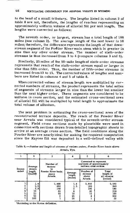
68 POSTGLACIAL CHRONOLOGY FOR ALLUVIAL VALLEYS IN WYOMING
to the head of a small tributary. The lengths listed in column 2 of table 8 are not, therefore, the lengths of reaches representing an approximately uniform volume of alluvial fill per unit length. The lengths were corrected as follows:
The seventh order, or largest, stream has a total length of 100 miles (see column 2). The average length of the next lower is 50 miles; therefore, the difference represents the length of that down stream segment of the Powder River main stem which is greater in size than any other order stream. The number of sixth-order streams is thus increased from 3 to 4 (compare columns 3 and 5).
Similarly, 25 miles of the 50-mile length of sixth-order streams represents that reach of the sixth-order stream equal or larger in size than fifth order. Thus, the number of fifth-order streams is increased from 12 to 15. The corrected values of lengths and num bers are listed in columns 4 and 5 of table 8.
When corrected values of stream length are multiplied by cor rected numbers of streams, the product represents the total miles of segments of streams larger in size than the lower but smaller than the next higher order. These segments are considered to be uniform in cross section, and the estimated cross-sectional area of alluvial fill will be multiplied by total length to approximate the total volume of alluvium.
The next problem is estimating the cross-sectional area of the reconstructed terrace deposits. The reach of the Powder River near Arvada was considered typical of the seventh-order stream segment. Field cross sections made by planetable were used in connection with sections drawn from detailed topographic sheets to arrive at an average cross section. The field conditions along the Powder River are nearly ideal for making the required computation since the Kaycee fill was deposited in a well-defined valley with
Table 8. Number and length of streams of various orders, Powder River basin aboveArvada, Wyo.
I
orderl
1234567
2
Average
length (miles)
1.42.95.8
122550
100
3
Number ofstreams
Powder River basin above
Arvada
1,400450140401231
4 5 6
Corrected to representsegments of approximately
uniform cross section
Average length (miles)
1.41.536
122550
Number of streams above
Arvada
1,850590180
521541
Total length of
all streams (miles)
2.590880540310180100
50
^According to the Horton definition.

PALEOHYDROLOGY 69
steep bedrock walls and, therefore, the valley width could be easily determined from the 10-foot contour maps.
Calculation of the volume of slope wash posed a problem. It is recognized throughout this study that slope wash graded to the Kaycee terrace blankets earlier gravels and bedrock in the areas between the rough hilly topography near the drainage divides and. the main valley trenches. This blanket of alluvium is in the form of a long, thin wedge increasing in thickness toward the river. It was decided to eliminate consideration of the volume in these wedges because this volume is small compared to that deposited in the valley trench. The slope wash within the confines of the valley it self was thought to be of sufficient volume to be included.
The average cross section chosen to represent the Kaycee alluvial fill can be seen in comparison with an actual section across the Powder River plotted in figure 23, sections A and B. The actual section shown at the right is within a reach studied in detail in the field. The Kaycee fill, shown in solid black, represents the allu vium of Kaycee age and younger now lying within the valley trench and abutting bedrock on the valley sides. It is shown to be only as deep as the present stream bed but it probably is somewhat deeper. It presumably overlies earlier gravels which partly fill the valley cut in bedrock.
On the slopes adjoining the valley, slope wash covers a thin layer of gravel, which may be locally absent, and which in turn lies on a surface cut on bedrock. As previously explained, the level of the stream of Kaycee time was at least as high as a projection of the wash slopes to intersection over the valley axis or to the opposite valley wall, as in the cross section A of figure 4. It is presumed, therefore, that the whole area represented by the solid black, plus the crosshatched area, represents an approximation of the cross section of Kaycee fill at the end of Kaycee deposition. Of course, since Kaycee time, erosion during Moorcroft and Lightning time has resulted in loss of part of the Kaycee alluvium and deposition of later alluvium in the valley.
Several cross sections were considered in choosing the assumed average section (B) shown in figure 23. The average height of intersection of the projected Kaycee wash slopes above the present stream was about 30 feet. The average width of valley for several measured sectio'ns was 2, 500 feet. The average height of the valley walls was 50 feet. Thus, the average cross section (B) is in the form shown in figure 23, with 30 feet of river terrace alluvium covered by two wedges of slope wash.
In a similar manner, cross sections of various sizes of streams measured in the field were used as the basis for estimating an average cross section for streams of different orders.

70 POSTGLACIAL CHRONOLOGY FOR ALLUVIAL VALLEYS IN WYOMING
Feet
3800 I
3700
3600 u-
U.S.G.S. datum
7TH ORDER STREAM
1000 FeetI
ASSUMED AVERAGE SECTION, KAYCEE FILL ACTUAL ALLUVIAL FILL,
POWDER RIVER AT MILE 12.4
B
Sqft
100,000 pr
10,000
345
Stream order
Figure 23. Cross-sectional area of Kaycee alluvial fill in relation to stream order. Diagram A shows an actual cross section of alluvium above present stream level (black area), and the part of the alluvium eroded away since Kaycee time (hatched area). Diagram B represents the assumed average cross section in the same reach of river. Diagram C shows the relation of computed cross-sectional area by various sizes of stream valleys to stream order which char acterizes the sizes of the valley.
After the average cross sections were determined, the computed cross-sectional area of Kaycee fill for each order of stream was plotted against stream order. The resulting graph shown as part C of figure 23 indicates that the estimated average sections bear a consistent relation one to the other.

PALEOHYDROLOGY 71
From the graph of figure 23, then, the area of Kaycee fill for each stream order was read and entered in table 9 for the com putation of volume of fill, which is expressed finally in acre-feet per square mile of drainage area.
The same procedure was used to determine the volume of alluvium representing the Lightning fill. It will be noted that for each cross section the computed volume does not take into account the unknown depths of fill below present stre-am level. The final columns, therefore, must be considered minimum values, but the error involved in not attempting to estimate the fill between stream level and the underlying bedrock or early gravels is probably of the same order of magnitude as other errors involved in the computation.
During Moorcroft time, erosion resulted in the formation in most valleys of a terrace cut on Kaycee alluvium; therefore, no attempt has been made to compute the volume of alluvium deposited during Moorcroft time.
Figure 9. Computation of volume of alluvium in Kaycee and Lightning fills, PowderRiver basin above Arvada
Stream
1234567
Totalmiles
of
2.59088054031018010050
Kaycee alluvium
Cross-sectionalarea of fill
(square feet)
1.0002,1004.600
10.00021,00046, 000
100,000
Totalvolume of fill(acre-feet)
31x10*22x10*30 xlO*38x10*46 x 10*56x10*60 x 10*
283 x 10*
Lightning alluvium
Cross -sectionalarea of fill
(square feet)
150320700
1,4002,9006,000
12,500
Total volume offill
(acre -feet)
47 x 10334 x 10s46 x 10352 x 10s63 x 10s73x10*76 x 10s
391 x 10s» , ., , , . Kaycee fill Lightning fillAverage volume per square mile of drainage area - £- - -=
470 acre-feet 65 acre-feet
The results may now be examined in the light of other types of data. The period of deposition in years for the Lightning fill is better known than for the Kaycee fill because of the analogy with dated alluvium in the Southwest. Deposition of fills contemporan eous with the Lightning formation probably began about A. D. 1400 and ended about 1850. The rate of sedimentation of Lightning fill based on 450 years would be 0. 14 acre-foot per square mile of drainage area per year.
The computation of rate of deposition of the Kaycee fill again rests on the assumption that it is correctly correlated with the sequence of events elsewhere, but the correlation is probably better than the necessary estimate of the span in years representing its deposition.

72 POSTGLACIAL CHRONOLOGY FOR ALLUVIAL VALLEYS IN WYOMING
It is necessary to use a date for the end of the Altithermal time, and because no figure is universally agreed upon yet, a round date of 4, 000 years ago may be a satisfactory average. This date relies in part on the radiocarbon date for the Chiricahua stage of the Cochise culture (Flint and Deevey, 1951), and this culture complex appears to fit satisfactorily with the end of Altithermal time or the beginning of Kaycee time. (See table 7.)
It is also necessary to use a date for the end of Kaycee time. For this, one must again lean heavily on the radiocarbon date of 2,,500 years for the San Pedro phase of the Cochise culture (Flint and Deevey, 1951). The span between 4, 000 and 2, 500 years ago is the best approximation for the Kaycee period of deposition that is possible at present, If, then, 470 acre-feet per square mile of drainage area we re deposited in 1, 500 years, the annual rate would be 0. 31 acre-foot per square mile.
These estimated rates will now be compared with rates of sed iment transportation by modern rivers and rates of accumulation of sediment in reservoirs. It must be remembered that during the deposition of alluvium in a river valley, sediment is constantly being carried out of the valley by the stream. The rate of depo sition must then be some fraction of the total sediment production.
Most modern streams in the Middle West and West are either degrading somewhat or are relatively stable. Rates of sediment movement, therefore, either represent the rate of sediment pro duction from the watershed, as in stable streams; or that rate augmented somewhat by erosion of previously deposited valley fill, as in degrading streams. Brown (1945) and Brune (1948) compiled data on rates of sediment production for the Southwest and Midwest, respectively. Their figures for estimated long-term annual sed iment production range widely among streams. Roughly, mid- western streams have values of 0.11 to 0. 39 acre-foot per square mile per year, and western streams 0. 56 to 1. 10 acre-feet per square mile of drainage area per year.
An examination of the difference between total suspended-load movement and load deposited will now be made. The Rio Grande is aggrading through the middle reaches of its valley, and is an example for which good records of both deposition and suspended- sediment load are available. Excluding the reach near the head of Elephant Butte Reservoir, the sediment deposited consists of roughly one-third of the total load brought into the valley (Thomas Maddock, Jr., personal communication).
If, according to this ratio, the estimated rates of deposition during Kaycee and Lightning times were increased threefold to approximate rates of sediment production, the resultant figures
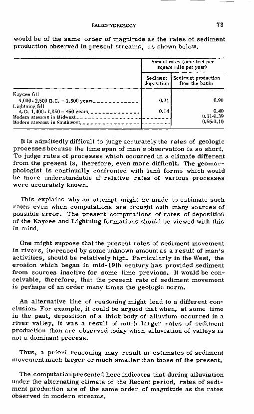
PALEOHYDROLOGY 73
would be of the same order of magnitude as the rates of sediment production observed in present streams, as shown below.
Kaycee fill 4,000- 2,500 B.C. - 1,500 years..................................
Lightning fill A.D. 1,400- 1,850 - 450 years......................................
Modern streams in Midwest................................................Modern streams in Southwest.............................................
Annual rates (acre-feet per square mile per year)
Sediment deposition
0.31
0.14
Sediment production from the basin
0.90
0.40 0.11-0.39 0.56-1.10
It is admittedly difficult to judge accurately the rates of geologic processes because the time span of man1 s observation is so short. To judge rates of processes which occurred in a climate different from the present is, therefore, even more difficult. The geomor- phologist is continually confronted with land forms which would be more understandable if relative rates of various processes were accurately known.
This explains why an attempt might be made to estimate such rates even when computations are frought with many sources of possible error. The present computations of rates of deposition of the Kaycee and Lightning formations should be viewed with this in mind.
One might suppose that the present rates of sediment movement in rivers, increased by some unknown amount as a result of man's activities, should be relatively high. Particularly in the West, the erosion which began in mid-19th century has provided sediment from sources inactive for some time previous. It would be con ceivable, therefore, that the present rate of sediment movement is perhaps of an order many times the geologic norm.
An alternative line of reasoning might lead to a different con clusion. For example, it could be argued that when, at some time in the past, deposition of a thick body of alluvium occurred in a river valley, it was a result of much larger rates of sediment production than are observed today when alluviation of valleys is not a dominant process.
Thus, a priori reasoning may result in estimates of sediment movement much larger or much smaller than those of the present.
The computation presented here indicates that during alluviation under the alternating climate of the Recent period, rates of sedi ment production are of the same order of magnitude as the rates observed in modern streams.

74 POSTGLACIAL CHRONOLOGY FOR ALLUVIAL VALLEYS IN WYOMING
The relations of rainfall to runoff during the period of accumu lation of valley alluvium must have been different from those ob taining at present when some measure of stability appears to characterize the rivers of eastern Wyoming. Is it possible, then, that rates of sediment production were of the same order as those observed at present?
Clearly, when stability is replaced by active gully erosion, as when the great valley trenches of the Rio Puerco of New Mexico and the Navajo country were being cut, sediment production changed from a very low to a very high rate. But in the Rio Puerco where good data in the form of successive surveys beginning in 1924 are avail able, a marked reduction in sediment movement occurred as soon as the valley trench had achieved a more or less stable depth. After deepening is complete and gradual widening becomes the dominant process, sediment production in a period of gully forma tion rapidly decreases.
Degradationby rapid valley trenching, as has occurred in many alluvial valleys of the Southwest, may be considered catastrophic as compared to alluviation under different conditions.
Consideration of the present conditions of erosion in New Mexico, Arizona, Utah, Colorado, and Wyoming suggest that the catas trophic gullying which began in the middle to late part of the 19th century has, to a great extent, run its course. Current extension of the small but ramified headwater gullies and gradual widening of the main stems are producing sediment at a much lower rate than obtained before the first two decades of the present century. The quantitative records of sediment movement are, with few excep tions, obtained from reservoirs and stock tanks built later than the period of catastrophic gully deepening.
If the computations of sediment production rates in Kaycee time have any validity, they suggest that except during the relatively short period of maximum arroyo deepening, sediment production rates remain of the same order of magnitude during periods of valley aggradation, stability, and the long period of headwater ramification of gullies constituting the major part of a period of valley degradation.
Such an interpretation gains some support from recent work on the nature of channel equilibria (Leopold and Maddock, 1953, and Wolman, in preparation). These studies suggest that evenduring gradual lowering of youthful headwater streams, the alluvial chan nel retains a quasi-equilibrium. The physical difference between a graded stream or reach and one which is not at grade may be less than was formerly believed.

RECENT PHYSIOGRAPHIC HISTORY AND THE PROBLEM OF SOIL EROSION 75
This reasoning points to the hypothesis that the physical char acteristics of a degrading stream and a stable one are similar. Indeed, a truly graded stream can be distinguished only under certain conditions, and probably only some time after it has reached the condition of grade, as has been suggested by Holmes (1952).
To the extent that these deductions are true, the streams of the somewhat cooler and more moist Kaycte time could be pictured as very similar to what can be seen in the same area today.
RECENT PHYSIOGRAPHIC HISTORY AND THE PROBLEM OF MODERN SOILEROSION
Soil erosion is one of the important agricultural problems of the day. The last two decades have seen a change from nearly a total lack of appreciation of this problem to a situation in which "accel erated erosion" is a household phrase. The time has come when the need for propagandizing the faith is replaced by a need for a more fundamental understanding of the erosion process and for testing under controlled conditions on large areas various methods of control.
It is obvious that the need for food in this country and in the rest of the world precludes any possibility of decreasing the total acreage of land under plow. As long as land is farmed, it is much more vulnerable to the action of erosive forces than it was in presettlement eras.
Because it can be so easily demonstrated that removal of vegetal cover greatly increases rates of erosion, and because man has so obviously affected the protective cover, it is difficult to distinguish in detail accelerated from geologic erosion. In fact, a survey of the voluminous literature on erosion reveals a great inadequacy in our definitions of normal, or geologic, erosion. These words are confusing. Normal erosion does not connote vertical-walled gullies cutting through a rolling, grassy prairie. Yet there is considerable evidence that such conditions were found in some places by early settlers in the western High Plains well before grazing or other influences of man were important (see Gregg, 1844, in Leopold, 1951c).
An under standing of our soil erosion problem and of the efficacy of control measures requires that we sharpen our tools for distin guishing those features of the modern landscape molded by natural forces alone and those related to activities of man. Geomorphology can provide techniques that will help us.
The purpose of the following section is to indicate that a study of recent physiographic history may aid in separating topographic
303189 O - 54 -

76 POSTGLACIAL CHRONOLOGY FOR ALLUVIAL VALLEYS IN WYOMING
features developed during the geologically recent but presettle- ment past from similar features resulting from man's use of the land.
RELATIVE AGES OF EROSION FEATURES OF THE PRESENT TOPOGRAPHY
The alluvial valleys of Wyoming, characterized as they are by well-developed terrace systems, offer an opportunity for studying the relative ages of certain topographic features which are related to the terrace system, and for drawing inferences about the proc esses of aggradation and degradation in a watershed. When a river incised itself into the Kaycee fill, the lowered stream bed pro vided a new base level, represented by the Moorcroft terrace, to which tributaries and wash slopes tended to become graded. There was initiated, therefore, a period of dissection. Before the dis section had progressed far, the master stream again was lowered markedly and then raised a small amount when the Lightning fill was inset in the valley trench.
Systems of erosion features developed on the highlands adjacent to the streams as a result of this sequence of events. Ascribing a relative age to these various erosion patterns is based on the premise that lowered base level will induce erosion of tributaries which eventually become more or less graded to the new level. The practical problem of age determination is one of separating the features developed as a result of general lower ing of base level following entrenchment of the main stream, from those features developed as a result of purely local causes unrelated to the general level of the main stream. Two types of erosion features of the latter type will now be discussed.
If fora period of time a river flows against one side of the valley floor, tributaries entering the valley on the opposite side splay detritus on the valley floor, building up a cone or a wash slope until the thin edge of the wedge of detritus reaches the master stream. If then the stream moves laterally across the valley, eroding into the wedge on the original valley floor, the base level of the tributary will be effectively lowered and in response it will cut down. A new trench will be formed in the valley of the tributary which was not caused by a general lowering of the level of the master stream, but resulted only from its lateral migration across its flood plain. This type of feature has been discussed by Mackin (1937).
A second type of erosion feature originating without change in the level of the master stream can be cited. For example, a segment of wash slope lies far up on the valley side and distant from the master stream. It is possible that as a result of a series of heavy

RECENT PHYSIOGRAPHIC HISTORY AND THE PROBLEM OF SOIL EROSION
local storms or local depletion of vegetation, a gully might form, which, over a period of time, could erode headward while continuing to deposit a fan at its mouth on the original wash slope, in a manner characteristic of discontinuous gullies. Such a feature could even grow to considerable size. The bed elevation of such a gully would be independent of the level of the master stream.
Two examples will now be cited in which a definite relation can be established between the erosion features of the tributaries and the sequence of events on the master stream.
The first example is a tributary of Twentymile Creek, 12 miles west of Lance Creek village. Wyo., in sec. 14, T. 35 N., R. 67 W. Twentymile Creek is an ephemeral wash, now characterized in its middle reach by an arroyo 15 feet deep and 30 feet wide incised in a wide, flat flood plain. The wash is entrenched and has widened only little since the last period of degradation. Most of the drain age area is underlain by shale of the Fort Union formation.
There are three terraces along Twentymile Creek, and corre lation of these surfaces with the Kaycee, Moorcroft, and Lightning formations is based on the criteria discussed earlier. The upper, or Kaycee, surface stands 40 feet above the present stream bed. This surface grades smoothly to the hills near the watershed divide and.thus stands in the same relation to other physiographic features as does the Kaycee terrace elsewhere. The upper two terrace levels, Kaycee and Moorcroft, are consistently traceable up and downstream along Twentymile Creek, but incision of the stream into the Lightning surface is discontinuous. The Lightning level is, therefore, a terrace in some places but the flood plain in others.
A tributary, called here Revision Draw, was mapped (see fig. 24)to show its relationship to the terrace features of Twentymile Creek.
The Kaycee terrace is lettered K on figure 24. It is dissected by long, narrow, flat-floored draws, some extending as far back as the hills constituting the divide, but including some short erosion channels, such ae Revision Draw pictured here. These flat-floored draws enter the valley of Twentymile Creek at the level of a terrace (M), remnants of which are traceable along the main valley. This is the Moorcroft terrace which stands about 20 feet above the stream. The stream is incised about 15 feet below the Lightning surface.
In the cross section on figure 24, dotted lines show the extension of the Kaycee surface to intersection at the axis of the main valley. The intersection occurs 13 feet above the Lightning surface, and it is clear that Twentymile Creek could not have been at a lower

78 POSTGLACIAL CHRONOLOGY FOR ALLUVIAL VALLEYS IN WYOMING
200 0
Figure 24. Topographic map«cross section, and block diagram of Revision Draw, a gully system tributary to Twentymile Creek, Wyo.

RECENT PHYSIOGRAPHIC HISTORY AND THE PROBLEM OF SOIL EROSION 79
elevation than that intersection when dissection of the Kaycee surface began.
On both sides of the valley, long and short tributary draws cut in the Kaycee surface are graded to the Moorcroft terrace level. In Revision Draw, the swale (M), accordant with the Moorcroft terrace, is about 600 feet long. It is flat-floored, as can be seen on the topographic map, and the floor has a grass cover which is as dense or more dense than that on the Kaycee surface. The walls are concave to the sky and they, too, are covered with grass.
In Revision Draw the Moorcroft surface is incised by a narrow, vertical-walled gully (L 1 ) 275 feet long, the floor of which is ac cordant with the Lightning surface. This gully has a vertical raw headcut 10 feet in height.
The mouth of this gully is also incised by another very short but vertical-walled notch (G) representing the incipient erosion feature graded to the present floor of Twentymile Creek.
It is believed that the draw (M)was developed during Moorcroft time and represents downcutting in response to the formation of the Moorcroft terrace in the valley of Twentymile Creek. The Moorcroft is a cut terrace developed on Kaycee formation.
Subsequently, Twentymile Creek incised itself below the Moor croft surface nearly as deep as the present floor of Twentymile Creek. As a result of this lowering of base level, a new erosion feature, gully L 1 , developed in the floor of Revision Draw. This gully was cut about 5 feet below the present level of the Lightning surface. The exposure on the gully wall indicates that at maximum depth the gully L 1 was rounded on the bottom rather than flat. As the Lightning fill was inset in the trench, the gully L' was partly filled and the present flat floor was developed. During the period of stability at the end of Lightning deposition, gully L' widened somewhat near its mouth.
It is postulated, therefore, that during the total elapsed time since downcutting of Twentymile Creek to the Moorcroft level, there has developed in Revision Draw a swale (M) 90Q feetlong. Erosion since the dissection of the Moorcroft surface has resulted in a gully (L 1 ) only 275 feet long. The downcutting into the Lightning surface has resulted in an incipient gully only 10 feet long.
The importance of this analysis lies in the use of terraces to determine the relative age of erosion features. A striking aspect of the example is the small size of features which may, under certain conditions, be eroded even in a long period of time. The second important feature is that vertical walls of alluvium, com-
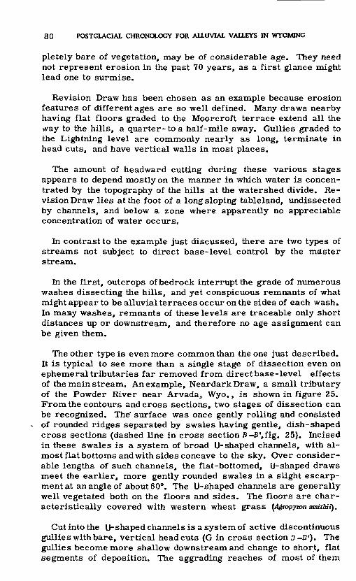
80 POSTGLACIAL CHRONOLOGY FOR ALLUVIAL VALLEYS IN WYOMING
pletely bare of vegetation, may be of considerable age. They need not represent erosion in the past 70 years, as a first glance might lead one to surmise.
Revision Draw has been chosen as an example because erosion features of different ages are so well defined. Many draws nearby having flat floors graded to the Moorcroft terrace extend all the \vay to the hills, a quarter- to a half-mile away. Gullies graded to the Lightning level are commonly nearly as long, terminate in head cuts, and have vertical walls in most places.
The amount of headward cutting during these various stages appears to depend mostly on the manner in which water is concen trated by the topography of the hills at the watershed divide. Re vision Draw lies at the foot of a long sloping tableland, undissected by channels, and below a zone where apparently no appreciable concentration of water occurs.
In contrast to the example just discussed, there are two types of streams not subject to direct base-level control by the mdster stream.
In the first, outcrops of bedrock interrupt the grade of numerous washes dissecting the hills, and yet conspicuous remnants of what might appear to be alluvial terraces occur on the sides of each wash. In many washes, remnants of these levels are traceable only short distances up or downstream, and therefore no age assignment can be given them.
The other type is even more common than the one just described. It is typical to see more than a single stage of dissection even on ephemeral tributaries far removed from direct base-level effects of the main stream. An example, NeardarkDraw, a small tributary of the Powder River near Arvada, Wyo., is shown in figure 25. From the contours and cross sections, two stages of dissection can be recognized. The' surface was once gently rolling and consisted of rounded ridges separated by swales having gentle, dish-shaped cross sections (dashed line in cross section B-B 1,fig. 25). Incised in these swales is a system of broad U-shaped channels, with al most flat bottoms and with sides concave to the sky. Over consider able lengths of such channels, the flat-bottomed, U-shaped draws meet the earlier, more gently rounded swales in a slight escarp ment at an angle of about 60°. The U-shaped channels are generally well vegetated both on the floors and sides. The floors are char acteristically covered with western wheat grass (Agmpymn smithii).
Cut into the U-shaped channels is a system of active discontinuous gullies with bare, vertical head cuts (G in cross section 3 -£?') The gullies become more shallow downstream and change to short, flat segments of deposition. The aggrading reaches of most of them

RECENT PHYSIOGRAPHIC HISTORY AND THE PROBLEM OF SOIL EROSION 81
400 Feet
DIAGRAMMATIC CROSS SECTIONS
100 200 300 400 500 600 700 Feet
Figure 25. Topographic map and profile of Neardark Draw, a small tributary to the Powder River near Arvada, Wyo. The draw is graded to an extensive remnant of the Moorcroft ter race which at this place separates by nearly one-half mile Neardark Draw from the main Powder River channel.

82 POSTGLACIAL CHRONOLOGY FOR ALLUVIAL VALLEYS IN WYOMING
are densely covered with wheat grass. The head cuts of the dis continuous channels range from 1 to 10 feet in height. Though there is considerable variation from place to place, there are many small tributary basins comparable to the one pictured in figure 25 in the hills bordering the Powder River valley.
The valley floor of Neardark watershed is graded to the Moor- croft terrace bordering the Powder River. It is possible, there fore, that the earlier stage of erosion represented by the dish- shaped channel is the headwater expression of the drainage system developed at the time when the Powder River flowed at the level of the Kaycee terrace. The U-shaped channels would then represent cutting, probably followed by some aggradation which formed their flat floors. This occurred during the time when the Powder River incised itself into the Kaycee surface toform the Moor croft terrace level.
If that is what took place, the present discontinuous gullies (like G on fig. 25) could be interpreted as having their beginning either during the period of erosion following Moorcroft time, or in the last 70 years coincident with the general but slight degradation of the main streams into the Lightning surface. According to the latter interpretation, dissection of the Moorcroft surface is not represented by any remnant feature in the uplands of this locality.
In summary, mention has been made of three types of relation ships between erosion features in the uplands and the terrace system along the major streams. The first type, Revision Draw, indicated a direct relation between tributary draws and the terrace system of a moderate sized stream. The relation in that example was clearly a direct base-level control. The second type of rela tion is represented by those headwater draws which exhibit local "terrace levels" but in which the "terrace" remnants are not trace able surfaces. In many such tributary valleys, outcrops of bedrock in the channel exclude the possibility of any control by the main valleys. The third type of relation is represented by Neardark drainage basin, a headwater basin removed from direct base-level control of the main Powder River. This small drainage exhibits a terrace above the present stream bed, and the latter is now undergoing degradation by discontinuous gullies.
A question important to an understanding of the mechanism of erosion may now be asked: Deposition in the main valleys and in major tributaries implies erosion somewhere in the headwaters in order to provide a source for the deposited materials. Why, then, would deposition downstream not be correlative with erosion in the smaller washes and draws of the uplands?
RECENT PHYSIOGRAPHIC HISTORY AND THE PROBLEM OF SOIL EROSION 83
The following discussion of this question is meant to apply to the great areas of rolling plains or uplands of moderate relief, and it does not involve the processes in mountain valleys.
The authors have dug trenches through the valley alluvium in small headwaters draws, and have extended by shovel the cross section exposed in the headcuts of discontinuous gullies in the uplands. Even headwater valleys only 5 to 15 feet wide consist of several feet of alluvium covering the bedrock. This alluvial mantle was, everywhere, considered to be of Kaycee age because its surface can be traced in a smooth unbroken curve down to merge into the Kaycee terrace.
The terraces of the master streams can be traced directly into many tributaries of moderate size, indicating that erosion of allu vium in the master streams was accompanied by gully erosion in tributaries, even the ephemeral ones.
Erosion of the major valleys was generally accompanied by erosion of tributary valleys. Likewise, aggradation in the main stream valleys was accompanied by deposition in tributary valleys and draws. Probably these deposits were derived by mass move ment and sheet erosion on upland slopes.
It seems logical that the shift in relations between runoff and vegetation which caused erosion of all major streams would also affect the smallest tributary valleys in a similar way at the same time. The alluvial material carried and deposited by the river was derived from the surrounding hills and slopes leading to the main channels. As the deposit in the main valley gradually increased in thickness and height and finally more than filled the valley trench, the wash slopes that were graded to the main river accu mulated material which blanketed all except the most prominent hills and uplands. The area of upland from which alluvial materials were being derived by erosion shrank, while the area of deposition increased. This doubtless had the effect of gradually decreasing the rate of rise of the main valley bed. There were both an ex panding area of deposition and a contracting area from which the materials were ultimately derived.
THE EROSION PROBLEM IN THE WEST
Aperiod of arroyo cutting or valley trenching began in the South west about 1885 with serious social and economic consequences. It is the view of some writers that the arroyo cutting can be as cribed entirely to the misuse of the land: overgrazing, logging, fires, and other misuses (Bailey, 1935; Bailey, Craddock, and Croft, 1947; Thornthwaite, Sharpe, andDosch, 1942; and others).

84 POSTGLACIAL CHRONOLOGY FOR ALLUVIAL VALLEYS IN WYOMING
Another point of view, expressed primarily by Bryan (1925, 1941), is that overuse of the land was a triggerpull which timed a change about to take place as a result of climatic shift.
With regard to the sequence of aggradation and degradation in dicated by stratigraphic studies, Bryan (1941, p. 233) says, "Some general causes other than overgrazing must be sought for the pre-Columbian episodes of dissection. Whatever the cause of recent arroyos, overgrazing by domestic animals can have had no influence on the formation of the early arroyos. "
Thornthwaite, Sharpe, and Dosch (1942) deny that climatic shift is necessary to explain the alluvial sequence. They hold (p. 89) that "***depositionat the lower ends [of headward-cutting arroyos] by back-filling of the channels***produced waves of sedimentation that migrated up valley. " They believe "***that the explanation of successive deposition and removal of fill lies in sedimentary proc esses and irregular occurrences of heavy storms rather than in any change of climate. "
The stratigraphic evidence which has accumulated since that discussion has certainly added weight to Bryan's climatic inter pretation of the pre-Columbian sequence. The comparability of sequences between areas is the basic support for the climatic hypothesis.
In explaining the recent epicycle of erosion, the general co incidence between initiation of arroyo cutting and the advent of heaviest grazing is agreed upon by all concerned. Moreover, the efficacy of intensive land use in promoting soil erosion is not at issue. The point of major disagreement is whether climatic change or misuse of land has been a greater cause of erosion.
From the assertion that climatic shift has, in part, been re sponsible for the arroyo problem, the conservationist is prone to draw the following inference:
If***a progressive desiccation of climate has brought about the dissection of the wes tern lands, there is little hope that man can stem the quickened erosion. If***misuse of the land***has been the cause, there is good possibility of improving the land by im proving the land use. (Thornthwaite, Sharpe, and Dosch, 1942, p. 2.)
The implications of the results of geologic studies of postglacial climatic variations on current problems of conservation and land use might better be viewed in the following light. Climatic variation has characterized the postglacial and historic period, as well as the Pleistocene epoch. There is in progress at present a climatic variation which has affected at least the major part of the Northern Hemisphere, and it is discernible in the climatic records of the Southwest (Leopold, 1951a)as well as in the geologic record of the

RECENT PHYSIOGRAPHIC HISTORY AND THE PROBLEM OF SOIL EROSION 85
same area. As shown in this report, the configuration of the whole landscape bears the imprint of this Recent climatic history.
A shift in climate may act on soil and vegetation in the same way as overuse by man, or the shift may act in an opposite way. If our present erosion problems are complicated by an interaction of land use and a varying climate, in the interest of better use of land and water we must recognize the action of both. We should study, when possible, the effects of each separately, and design our land treatment programs to insure maximum benefits under these conditions. Recognition of the current climatic variation does not require an abandonment of measures for improvement of land use. It should, in fact, spur us to greater effort to protect key watersheds from overuse, and currently to balance utilization with the varying capacities of watersheds. It should, likewise, point to the importance of spending our conservation dollar on areas where climatic and land use factors combine to justify reasonable hope of success.
Erosion features, such as gullies, observable over great areas in Wyoming, are not all of the same age. The present report out lines some of the problems of determining the ages of features whose outward aspects are sufficiently similar to suggest that they are all related to the recent cycle of arroyo cutting. Evaluation of the effects of land use and programs of land use improvement should recognize the existence of a difference in age of erosion features. Further research of this nature appears desirable.
In the present report, estimates are made of the rate of deposition of valley alluvium during the postglacial but pregrazing periods of aggradation. These estimates suggest that rates of sediment pro duction during those periods were similar to those of the present for the same area. The similarity in rates of sediment production, past and present, emphasizes the similarity in the hydrologic processes which characterize the effect of a climatic shift and the effect of depletion of vegetation by overuse. This similarity of rates suggests also similarity in end results. Study of the magni tude of depositional and degradational processes of the past pro vides some picture of the possible end points of the present erosion epicycle.

86 POSTGLACIAL CHRONOLOGY FOR ALLUVIAL VALLEYS IN WYOMING
REFERENCES CITED
Albritton, C. C., and Bryan, Kirk, 1939, Quaternary stratigraphy in the Davis Mountains,trans-Pecos, Tex.: Geol. Soc. America Bull., v. 50, p. 1423-1474.
Antevs, Ernst, 1928, The last glaciation: Amer. Geog. Soc., Research ser. 17, 292 p. 1948, The great basin, with emphasis on glaci.al and postglacial times: part
3, Utah Univ. Bull., v. 38, no. 20, p. 168-191. Bailey, R. W., 1935, Epicycles of erosion in the valleys of the Colorado Plateau: Jour.
Geology, v. 43, no. 4, p. 337-355.Bailey, R. W., Craddock, G. W., and Croft, A. R., 1947, Watershed management for sum
mer flood control in Utah: U. S. Dept. Agri. Misc. Pub. 639. Barbour, E. H., and Schultz, C. B., 1932, The Scottsbluff bison quarry and its artifacts:
Nebraska State Mus. Bull., v. 1, no. 34, p. 283-286. Blackwelder, Eliot, 1914, Post-Cretaceous history of the mountains of central western
Wyoming: Jour. Geology, v. 23, p. 307-340. Brown, C. 3., 1945, Rates of sediment production in Southwestern United States: U. S.
Soil Conserv., SCS-TP-58, 40 p. Brune, G. M., 1948, Rates of sediment production in Midwestern United States: U. S. Soil
Conserv., SCS-TP-65, 40 p. Bryan, Kirk, 1925, Date of channel trenching (arroyo cutting), in the arid Southwest:
Science, v. 42, no. 1607, p. 338-344. 1934, Geomorphic processes at high altitude: Geog. Rev., v. 24, p. 655 656. ; 1941, Pre-Columbian agriculture in the Southwest, as conditioned by periods
of alluviation: Assoc. Am. Geogr. Annals, v. 31, no. 4, p. 219-242.-1950, The geology and fossil vertebrates of Ventana Cave, in Haury, W. W.,
The stratigraphy and archeology of Ventana Cave, Tucson, Univ. Arizona Press, 599 p. Bryan, Kirk, and Albritton, C. C., 1943, Soil phenomena as evidence of climatic changes:
Am. Jour. Sci., v. 241, p. 469-490. Bryan, Kirk, and McCann, F. T., 1943, Sand dunes and alluvium near Grants, N. Mex.:
Am. Antiquity, v. 8, p. 281-290.Bryan, Kirk, and Ray, L. L., 1940, Geologic antiquity of the Lindenmeier site in Colo
rado: Smithsonian Misc. Coll., v. 99, no. 2, 76 p. Davis, W. M., 1902, River terraces in New England: Harvard Univ. Mus. Comp. Zoology
Bull., v. 38, p. 281-346. Evans, G. L., and Meade, G. E., 1945, Quaternary of the Texas High Plains: Texas
Univ. Pub. 4401, p. 485-507. Faegri, K., 1950, On the value of paleoclimatological evidence: Royal Meteorol. Soc.
Centenary Proc., p. 188-195. Flint, R. F., and Deevey, E. S., 1951, Radiocarbon dating of late-Pleistocene events:
Am. Jour. Sci., V. 249, p. 257-300. Hack, J. T., 1942, Tjie changing physical environment of the Hopi Indians: Peabody Mus.
Nat. History Papers, v. 35, no. 1, p. 3 85. Harbeck, G. E., and Langbein, W. B., 1949, Normals and variations in runoff, 1921-45:
Water Res. Rev., supp. 2, U. S. Geol. Survey. Holmes, D. C., 1952, Stream competence and the graded stream profile: Am. Jour. Sci.,
v. 250, p. 899-906. Horton, R. E., 1945, Erosional development of streams and their drainage basins: Geol.
Soc. America Bull., v. 56, no. 3, p. 275 370. Hoyt, W. G., 1936, Studies of relations of rainfall and runoff in the U. S.: U. S. Geol.
Survey Water-Supply Paper 772. Huffington, R. E., and Alb'ritton, C. C., 1941, Quaternary sands on the southern High
Plains of western Texas: Am. Jour. Sci., v. 239, p. 325-338. Hunt, C. B., and Sokoloff, V. P., 1950, Pre-Wisconsin soil in the Rocky Mountain region,
a progress report: U. S. Geol. Survey Prof. Paper 221 G. Judson, S., 1953, Geologic antiquity of the San Jon site, eastern N. Mex.: Smithsonian
Misc. Coll., v. 121, no. 1, 70 p. Kelley, J. C., Campbell, T. N., and Lehmer, D. J., 1940, The association of archeologi-
cal materials with geological deposits in the Big Bend region of Texas: Sul Ross StateTeachers Coll. Bull., v. 21, no. 3.
Leopold, L. B., 1951a, Rainfall frequency, an aspect of climatic variation: Am. Geophys.Union Trans., v. 32, no. 3, p. 347-357.
1951b, Pleistocene climate in New Mexico: Am. Jour. Sci., v. 249, p. 152-168 and 399.
-1951c, Vegetation of southwestern watersheds in the nineteenth century:Geog. Rev., v. 41, p. 295-316.

REFERENCES CITED 87
Leopold, L. B., and Maddock, Thomas, Jr., The hydraulic geometry of stream channels and some physiographic implications: U. S. Geol. Survey, Prof. Paper 252.
Leopold, L. B., and Snyder, C. T., 1951, Alluvial fills near Gallup, N. Mex.: U. S. Geol. Survey, Water-Supply Paper 1110-A.
Lueninghoener, G. C., 1947, The Post-Kansas geologic history of the Lower Platte Val ley area: Nebraska Univ. Studies (new ser.), no. 2, 82 p.
Lysgaard, L., 1949, Recent climatic fluctuations: Folio, Geogr. Danica, torn 5, 85 p.Mackin, J. H., 1937, Erosional history of the Bighorn Basin, Wyo.: Geol. Soc. America
Bull. 48, p. 813-894,McDonald, C. C., and Langbein, W. B., 1948, Trends in runoff in the Pacific Northwest:
Am. Geophys. Union Trans., v. 29, no. 3, p. 387-397.Moss, J. H., 1951, Early man in the Eden Valley: Pennsylvania Univ. Mus. Mon., 124 p.Nikiforoff, C. C., 1936, Some general aspects of chernozem formation: Soil Sci. Soc.
America Proc., v. 1, p. 333 342. 1937, General trends of the desert type of soil formation: Soil Sci., v. 43,
p. 105-125.Oltman, R. E., and Tracy, H. J., 1951, Trends in climate and in precipitation-runoff re
lation in Missouri River basin: U. S. Geol. Survey Circ. 98.Pettier, L. C., 1949, Pleistocene terraces of the Susquehanna River, Pa.: Pennsylvania
Geol. Survey, 4th ser. Bull. G 23, 158 p.Petterssen, S., 1949, Changes in the general circulation associated with the recent cli
matic variation: Geografiska Annaler, HSfte 1-2, p. 212-222.Robinson, G. W., 1949, Soils, their origin, constitution and classification: New York,
Wiley and Sons, 573 p.Rolfe, B. N., and Jeffries, C. D., 1952, A new criterion for weathering in soils: Science,
v. 116, p. 599-600.Sayles, E. B., and Antevs, Ernst, 1941, The Cochise culture: Madallion Papers no. 29,
Gila Pueblo, Globe, Ariz., 81 p.Schove, D. J., 1950, The climatic fluctuation since A. D. 1850 in Europe and the Atlan
tic: Royal Meteorol. Soc. Quat. Jour., v. 76, no. 328, p. 147-165.Schultz, C. B., and Eiseley, L., 1935, Paleontological evidence for the antiquity of the
Scottsbluff bison quarry and its associated artifacts: Am. Anthropologist, v. 37, no. 2, new ser., p. 287-306.
Schultz, C. 3-., Lueninghoener, G. C., and Frankforter, W. D., 1951, A graphic resume of the Pleistocene of Nebraska: Nebraska Univ. State Mus. Bull., v. 3, no. 6, 41 p.
Thornthwaite, C. W., Sharpe, C. F. S., and Dosch, E. F., 1942, Climate and accelerated erosion in the arid and semiarid Southwest, with special reference to the Polacca Wash drainage basin, Arizona: U. S. Dept. Agr. Tech. Bull. 808, 134 p.
Willett, H. C., 1949, Long period fluctuations of the general circulation of the atmos phere: Jour. Meteorology, v. 6, no. 1, p. 34 50.
1950, The general circulation at the last (Wurm) glacial maximum: Geo grafiska Annaler, HSfte 3-4, p. 179-187.
Wolman, M. G., in preparation, The channel characteristics of the Brandywine Creek, Pa.: U. S. Geol. Survey Prof. Paper.


INDEX
Page Aggradation, climatic influence......... 65-66
rate of, by modern streams............... 72compared with sediment produc
tion..................................... 72-73method of computation...............66-68
Arvada formation, features................ 8, 10frost action.....................,...........19, 20
Calcium carbonate, concentration inrelation to depth.................... 24-25
concentration related to soil texture. 52 depth of zone...............................50-51pedologic origin........................... 50-51
Caliche crust, formation.................... 10Clear Creek, features of deposition..... 61-65Climate, fluctuations...................... 55-56
in Altithermal time..................... 54-55in post-Altithermal time............... 55regional similarity....................... 57
Deposition, variables of................... 61-66
Erosion, caused by overuse of land. 75, 84, 85 climatic influence.................. 57, 84, 85features, ages of.......................... 76-83in Altithermal time...................... 55
Faegri, K. , quoted.......................... 57Fills, "inset* relation....................... 5-6
"overlapping" relation................... 5-6relationship to terraces................... 5stratigraphic relations..................... 5
Fort Union formation, features............. 19
Glacial activity, late Wisconsin time... 53 Gravel deposits, late Wisconsin time.... 53
Kaycee formation, aggradation rate.....71-72contact with bedrock...................... 42correlation with Cody terrace........... 33correlation with Fivemile Creek
terrace.................................. 38correlation with Muddy Creek terrace. 38 correlation with terrace on Middle
Fork of Popo Agie River............ 39correlation with terrace on Pass
Creek ................................... 39deposition..................................... 55description of.............................. 21-25mineral composition, analysis.......... 25relationship to glacial sequence........ 49size and sorting of alluvium............. 25terrace height, Belle Fourche River.. 33
Bighorn River basin.................... 40Cheyenne River basin................. 43Powder River basin..................... 29upper Clear Creek...................... 48
type locality................................ 11volume...................................... 70-71
Page Lenore terrace, correlation............... 35Lightning formation, aggradation rate.. 71
correlation with Fivemile Creekterrace................................ 38
correlation with Muddy Creekterrace................................ 38
correlation with terrace on MiddleFork of Popo Agie River.......... 39
correlation with terrace on PassCreek................................. 39
description................................. 11terrace height, Belle Fourche River. 33
Bighorn River basin................... 40Cheyenne River basin................ 43Powder River basin................... 29upper Clear Creek.................... 48
type locality.............................. 11volume..................................... 71
Lysgaard, L., quoted...................... 56
Moorcroft formation, correlation withFivemile Creek terrace.......... 38
correlation with Muddy Creekterrace............................... 38
correlation with terrace on MiddleFork of Popo Agie River......... 40
correlation with terrace on PassCreek................................ 39
description............................... 47 -48terrace height, Belle Fourche
River................................ 33Bighorn River basin................. 40Cheyenne River basin.............. 43Powder River basin................. 29upper Clear Creek.................. 48
Moraines, correlation of terraceswith................................. 47
Paleohydrology, defined................ 60Paleosol, defined......................... 10
profile development................... 51Petterssen, S. , cited..................... 56Powder River, features of deposition. 61-65
Sand dunes, dating....................... 38Sediment production, rates............. 72-75Slope wash, on terraces................. 46
volume................................... 69Soil, pedalfer-type, significance..... 51 Stream order, explained................ 68, 71
Terrace deposits, volume............... 68-71Terraces, age of erosion features..... 76-83
height.....................l2, 14, 15, 46, 47morphology.............................. 12regional correlation.................... 58-59relationship to alluvial fill........... 5strath...................................... 3stratigraphic characteristics..... 12, 15-16
89