Embed Size (px)
Citation preview

A manual for the survey and evaluation of the aquatic
plant and invertebrate assemblages of grazing
marsh ditch systems
Version 6
Margaret Palmer
Martin Drake
Nick Stewart
May 2013

2
Contents Page
Summary 3 1. Introduction 4 2. A standard method for the field survey of ditch flora 5
2.1 Field survey procedure 5 2.2 Access and licenses 6 2.3 Guidance for completing the recording form 6 Field recording form for ditch vegetation survey 10 3. A standard method for the field survey of aquatic macro-
invertebrates in ditches 12 3.1 Number of ditches to be surveyed 12 3.2 Timing of survey 12
3.3 Access and licences 12 3.4 Equipment 13 3.5 Sampling procedure 13 3.6 Taxonomic groups to be recorded 15 3.7 Recording in the field 17 3.8 Laboratory procedure 17
Field recording form for ditch invertebrate survey 18 4. A system for the evaluation and ranking of the aquatic plant and macro-invertebrate assemblages of grazing marsh ditches 19
4.1 Background 19 4.2 Species check lists 19 4.3 Salinity tolerance 20 4.4 Species conservation status categories 21 4.5 The scoring system 23 4.6 Applying the scoring system 26 4.7 Testing the scoring system 28 4.8 Conclusion 30
Table 1 Check list and scoring system for target native aquatic plants of ditches in England and Wales 31
Table 2 Check list and scoring system for target native aquatic invertebrates of grazing marsh ditches in England and Wales 40 Table 3 Some common plants of ditch banks that indicate salinity 50 Table 4 Aquatic vascular plants used as indicators of good habitat quality 51
Table 5a Introduced aquatic vascular plants 53 Table 5a Introduced aquatic invertebrates 54 Figure 1 Map of Environment Agency regions 55
5. Acknowledgements 56 6. References 56

3
Summary
1. This manual describes standard methods for surveying the aquatic vegetation, aquatic
macro-invertebrate assemblages and environmental variables of grazing marsh ditch systems.
2. Check lists of target species are given. 3. Each species is given scores to reflect its conservation status and salinity tolerance.
Plant species sensitive to nutrient enrichment are identified. 4. The use of metrics for evaluating the nature conservation value of plant and invertebrate
assemblages of grazing marsh ditch systems is explained. These scores are for separate attributes: Native Species Richness, Species Conservation Status, Habitat Quality and Community Naturalness.
5. The metrics can be used to rank wetlands, to identify the highest (and lowest) quality
ditches within a wetland, and to monitor change in the quality of ditch biota over time. 6. The evaluation system has been tested and refined during an investigation of coastal
grazing marsh ditch systems in England and Wales, carried out between 2007 and 2009 by Buglife – The Invertebrate Conservation Trust.
Note
Version 6 of this Manual updates Version 5, issued by Buglife in 2012. Version 6 incorporates recent additions to the British aquatic invertebrate fauna and the vascular plant flora of ditches (see Tables 1 and 5a).

4
1 Introduction
Ditches in England and Wales are of great importance for biodiversity, and are especially rich in aquatic invertebrates and plants. These networks of channels, although artificial, act as refuges for communities typical of previously extensive natural wetland systems. Ditch complexes are found in wetlands such as fens, grazing marshes and water meadows. Among the most extensive and species-rich ditch systems are those in the fenlands of Cambridgeshire and Lincolnshire and in the grazing marshes of Norfolk Broadland, the Pevensey Levels, Romney Marsh, the Somerset and Gwent Levels, and the Thames and Humber estuaries. Most of the coastal grazing marsh systems display a transition from fresh to saline water, which is an important factor in maintaining their biodiversity. Some ditches running through arable land support rare species or rich assemblages (Mountford & Arnold, 2006), but these are the exception in this type of landscape. Many of the most extensive ditch systems lie within Sites of Special Scientific Interest, but the flora and fauna of ditch systems in general may be threatened by agricultural pollution, unsuitable water level management, wholesale mechanical ditch clearance and climate change. Coastal and flood plain grazing marsh is a priority habitat under the UK Biodiversity Action Plan and numerous UK Biodiversity Action Plan priority species are associated with ditch systems. Schemes to recreate coastal grazing marshes may become necessary to replace habitat lost as a result of the ‘squeeze’ created by rising sea levels. The European Water Framework Directive (WFD) aims to improve the ecological status of inland and coastal waters. Aquatic plants and invertebrates are among the ‘quality elements’ used to assess the ecological status of surface water bodies. Although the principal surface waters targeted under the WFD are large lakes, rivers, transitional waters and coastal waters, the functional importance of wetlands is acknowledged. Natura 2000 Sites (Special Areas of Conservation under the EC Habitats Directive and Special Protection Areas under the Birds Directive) are designated under the WFD as Protected Areas, to which the WFD’s full programme of measures can be applied. Some grazing marshes and fens containing ditch networks are Natura 2000 sites. In order to conserve the biodiversity of these ditch systems it is necessary to assess their value in a national context and to monitor their condition. This should help in understanding what constitutes the optimum management regime for the ditches themselves and their immediate catchment areas. Standarised survey and conservation evaluation methods are essential tools for monitoring. This Manual presents such a methodology, which can be applied to the aquatic plant and invertebrate assemblages of coastal and flood plain grazing marsh ditches in England and Wales. A few changes (e.g. to the target list of invertebrate species and to the emphasis on salinity gradient) would be necessary to make the manual applicable to wetlands (e.g. fenlands) in England and Wales other than coastal grazing marshes and flood plain marshes in the lower reaches of rivers. Further modifications would be needed in order to apply the scheme to Scotland. The survey protocols for aquatic vegetation and invertebrates described in this manual are based on methods that have been in use for several decades by the British statutory nature conservation agencies (now Natural England and the Countryside Council for Wales). The survey and evaluation methods presented here have been tested during a three year project managed by Buglife – The Invertebrate Conservation Trust, which covered coastal and flood plain grazing marshes in Somerset, Sussex, Kent, Essex, Suffolk, Norfolk, Gwent and Anglesey (Drake et al., 2010).

5
2 A standard method for the field survey of ditch flora
2.1 Field survey procedure
Timing Vegetation is surveyed in the period from mid June to the end of September. Site selection In order to produce an adequate picture of the vegetation, at least 20% of the ditches in a relatively homogeneous complex should be sampled. If ample financial and time resources are available, more ditches should be covered. For sites that are varied, for instance with brackish as well as freshwater ditches, at least 20% of ditches in each habitat type should be sampled. The mean number of plant species per sample rises steeply the more ditches are sampled, but this increase levels off at around twenty samples. It is therefore recommended that a minimum of twenty ditches in a wetland is sampled. If comparison between surveys is a consideration, sample sites are chosen to coincide with previous vegetation surveys or with concurrent invertebrate surveys (see Section 3 of this manual). Otherwise, sampling sites are initially chosen using random numbers. However, if it becomes obvious later, in the field, that sampling has not covered the full range of vegetation types present in the complex, substitute ditches should be sampled. Ditch junctions, ditch ends or culverted gateways are avoided. Within each ditch to be surveyed, one 20 metre stretch is selected as the core sampling area. The position of all sampling sites should be recorded with a GPS unit, using an 8 figure grid reference. Survey method The vegetation is surveyed using a modified version of the method developed in the 1980s (Alcock & Palmer, 1985), and used with some variations in many ditch surveys since. Within each 20 metre section, the plants growing in the ditch and on its banks are recorded (see Section 2.3). A rapid ‘sweep-up’ to record additional species present in the rest of the ditch is carried out after the 20 metre section has been surveyed. Other species seen in transit around the site are recorded in the ‘Notes’ section on the recording form, so that a comprehensive species list can be compiled for the whole site. Ditches are normally recorded from one bank only. Sampling within the ditch is carried out with the aid of a grapnel (metal hooks on a rope) thrown into the ditch at regular intervals along the 20 metre section, or by using a pole with a hook on the end. A pole should be carried for depth measurements (see below) and safety requirements. All vascular plants, stoneworts and prominent mosses are recorded to species where possible, or to aggregate where sufficient diagnostic characters are not available. Filamentous green algae are recorded but are not separated to genus or species. The target aquatic species used in assessing the conservation value of ditch systems are listed in Table 1 (native species) and Tables 5a and 5b (introduced species). Where possible, identification is done in the field, but if necessary samples are kept for examination later, using a microscope. A sample of the more critical species from each survey area is preserved for independent verification.
Other features of the ditch are recorded on a standard field recording form (see Section 2.3). Sketches of ditch cross-sections are useful adjuncts to the recording form. A photograph should be taken at each sampling site.

6
2.2 Access and licences
Permission should always be sought from the landowner or land manager before survey is undertaken. If the site is an SSSI, Natural England or the Countryside Council for Wales should be contacted in the planning stage. If survey is to be carried out on a site where a ditch plant protected by listing on Schedule 8 of the Wildlife and Countryside Act 1981 has been recorded (e.g. Alisma gramineum, Leersia oryzoides, Luronium natans), a licence may be needed. The surveyor should seek advice from Natural England or the Countryside Council for Wales.
2.3 Guidance for completing the recording form
A standard recording form for ditch vegetation survey is given on pages 11 and 12. This should be filled in as explained in the following sections. Adjacent land use This is the main land use beyond the bank top. Normally this is based on the land upto 25 metres from the ditch or to the next ditch if this is closer (as is often the case when the adjacent land use is a drove/track). More than one box can be ticked where appropriate (e.g. hay/sileage and aftermath grazing). The terms improved, semi-improved and unimproved grassland are difficult to define in a consistent way. Essentially, improved grasslands tend to have rye grass at over 50% cover while unimproved grasslands will have low levels of rye grass and usually rushes (Juncus species) and/or some diversity of herb species. Ditch features
The recording form gives bandings for recording bank top and water widths, freeboard and bank slopes. These features are recorded by ticking the appropriate boxes.
Water and silt depth are recorded to the nearest 10 cm.
Conductivity is recorded to the nearest 10 µScm-1
.
pH is recorded to the nearest 0.1.
Turbidity is recorded on a five point scale based on 1 = gin clear, 3 = base of ditch just visible at 50cm, 5 = visibility < 10cm.
Water colour is recorded by looking into the ditch at a white marker on the end of a ranging pole, rather than taking water out and looking through a bottle, but this is only possible if turbidity is low. Peatiness can be recorded on a five point scale based on 1 = gin, 2 = lemon juice, 3 = white wine (chardonay), 4 = medium black tea, 5 = black coffee.

7
Bank slope is based on the angle from the bank top to the water's edge, irrespective of variations between the lower and upper sections.
Profile under water is the angle of the bank from water level to about 20cm depth. It is an indicator of the amount of shallow water at the margins.
Bank vegetation This section deals mainly with the ground and field layers below 1.5 metres height (including reeds etc taller than this). The amount of shade from canopy over 1.5 metres above the ground is recorded as a percentage under ‘Shaded’. The extent of each of the vegetation types is assessed using a DAFOR scale (see Species recording, below). ‘Tall grass/reed’ includes vegetation over 50 cm tall, as opposed to short grass, which is less than this. The former includes reed grasses, rushes and large sedges but normally Arrhenatherum elatius, Dactylis glomerata and Elytrigia repens type grasslands have the bulk of their biomass below 50 cm and count as ‘Short grass’. ‘Tall herbs’ includes tall communities not dominated by grasses or sedges, such as stands of Urtica dioica, Epilobium hirsutum, Filipendula ulmaria, Calystegia sepium and Persicaria hydropiper. Lower growing herbs are recorded under ‘Short grass’. ‘Scrub’ includes brambles, where these form significant patches rather than just scattered stems in other vegetation. ‘Fen’ is a rare category where the ditch merges directly into fen vegetation (although in some previous ditch surveys it has been used for reed-dominated banks). ‘Woodland ground flora’ includes Hedera helix, ferns, and other woodland herbs and grasses but not stands of Phragmites australis or Urtica dioica even if under dense shade.
Vegetation cover Vegetation cover is recorded on a DAFOR scale (see Species recording, below) based on the area of the ditch that is flooded for the majority of the year. This includes partially vegetated mud, Agrostis patches, beached Lemna etc exposed in partially dried out ditches, or where the water level has obviously been lowered. If the normal water level is not apparent, the current level is used. Some emergents (particularly Phragmites) can be dense but have thin stems that occupy only a small area of the water surface. For the purposes of emergent cover, open water surface and open substrate, abundance should be estimated as though each emergent stem occupied a radius of about 5 cm. Floating and submerged aquatics should, however, be recorded based using their actual areas. ‘Floating Lemna/Azolla’ includes Spirodela polyrhiza and Wolfia arrhiza but not Lemna trisulca. Floating liverworts such as Ricciocarpus natans are included here. ‘Other floating aquatics’ includes Hydrocharis morsus-ranae, water lilies and Potamogeton natans. It also includes the floating leaved stages of emergent species such as Alisma, Sagittaria, Persicaria amphibia etc and the early stages of Hydrocotyle ranunculoides before it starts forming floating rafts. ‘Submerged plants’ includes the underwater leaves of emergent and floating species. Because of differences in the ecological dynamics, Lemna trisulca is recorded separately from other submerged species. Stratiotes aloides should be recorded as a submerged plant even though the leaves often protrude on or above the water surface in summer. ‘Open substrate’ is the amount of substrate that can be seen looking down into the ditch (i.e. not covered by emergents, floating or submerged plants or algae). ‘Low swamp/Floating mat’ covers low growing swamp species (less than 50 cm above the water surface) such as the small Glyceria species, Eleocharis palustris, Alisma spp., Butomus umbellatus and Berula erecta. It also includes low growing wetland species that extend out over the water surface, such as Myosotis scorpioides, Apium nodiflorum, Rorippa nasturium-aquaticum and Hydrocotyle ranunculoides. In some previous ditch surveys, this category was titled ‘Floating mat’ and was used exclusively for floating rafts of the latter group of species.

8
‘Exposed vegetated’ and ‘Exposed mud’ include areas exposed by low water levels in partially or completely empty ditches. ‘Shaded’ is the amount shaded by trees and scrub over 1.5 metres tall, but not including overhanging Phragmites and other non-woody vegetation. ‘Emergents/floating mat in channel’ is recorded as a percentage to the nearest 10%, except at very low covers in the 0-10% range. The channel excludes the emergent fringe of the ditch (around 50cm out from the edge) even when there is not much emergent fringe present. It is therefore equivalent to the aquatic zone of the species recording (see below). The aim of this measure is to indicate the period of time since the last clearance. If there are reasons to suggest that this measure does not reflect this, it should be noted in the notes section. Grazing/vegetation structure These features are recorded on a scale of absent, low, medium and high and should be assessed on the visible impact rather than the actual situation at the time of survey. In other words, grazing levels can be recorded as high if it has evidently been so, even if there are no animals actually present. The assessment should also be based on the ditch banks, for example where grazing animals are excluded by temporary or permanent fencing. Where there is variation, for example where there is a low gradient cattle access area, the predominent level is recorded. ‘Poaching’ covers situations where the ground level has been broken by the weight of the livestock animals. ‘Block formation’ occurs where poaching is extensive enough to leave isolated raised blocks. ‘Shelf formation’ occurs where the poaching has resulted in a low gradient zone backed by a steeper turf bank or cliff. ‘Tangledness’ is a reflection of the heterogeneity of the ditch vegetation, an important feature for invertebrates. The scale is as follows: none Empty of vegetation (e.g. recently cleaned). low Ditches with very little vegetation; homogenous stands of submerged plants next to
vertical margins; very dense stands of emergents (e.g. ditches dominated by Glyceria maxima); or with dominant floating plants (duckweeds, Azolla, algae).
medium Intermediate between 1 and 3 (this is subjective); usually ditches with moderately high cover of vegetation but tending to large patches of each abundant species, often with little disturbance by cattle.
high Complex vegetation stands, usually botanically diverse, but more importantly structurally diverse (e.g. mats of Berula erecta mixed with a trampled fringe of emergents with moderate cover of submerged vegetation such as Ceratophyllum species).
‘Grassy margin’ gives a rough estimate of the degree of development of a submerged sward of small grasses, often in the shallow water at the ditch edge, or more rarely as a floating mat over deep water. The grasses include the soft species such Agrostis stolonifera, Glyceria fluitans and Catabrosa aquatica, and terrestrial grasses submerged when water levels rise and whose structure is similar to that of amphibious species. Excluded species are short-grazed terrestrial grasses and stiff plants such as Eleocharis and tall Juncus with dead stems drooping into the water; as they do not have the complex structure that invertebrates such as beetles appear to prefer. The provisional scale is: none No submerged grasses at the margin or as a floating mat. low Percentage cover less than c. 5% of the sampled ditch length, but still present in
isolated patches. medium Percentage cover 5 – 50% of the sampled ditch length, and forming a
large proportion of the netted habitat. high >50% of the sampled ditch length.
9
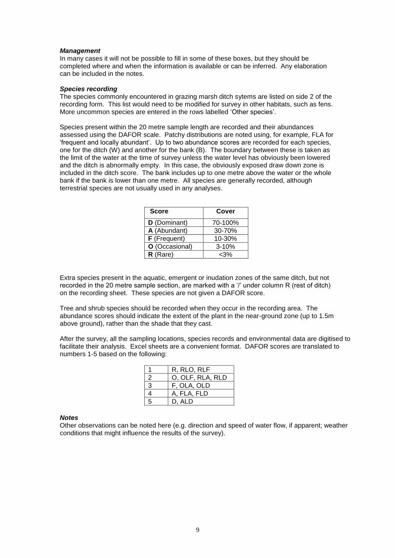
Management In many cases it will not be possible to fill in some of these boxes, but they should be completed where and when the information is available or can be inferred. Any elaboration can be included in the notes. Species recording The species commonly encountered in grazing marsh ditch sytems are listed on side 2 of the recording form. This list would need to be modified for survey in other habitats, such as fens. More uncommon species are entered in the rows labelled ‘Other species’. Species present within the 20 metre sample length are recorded and their abundances assessed using the DAFOR scale. Patchy distributions are noted using, for example, FLA for ‘frequent and locally abundant’. Up to two abundance scores are recorded for each species, one for the ditch (W) and another for the bank (B). The boundary between these is taken as the limit of the water at the time of survey unless the water level has obviously been lowered and the ditch is abnormally empty. In this case, the obviously exposed draw down zone is included in the ditch score. The bank includes up to one metre above the water or the whole bank if the bank is lower than one metre. All species are generally recorded, although terrestrial species are not usually used in any analyses.
Score Cover
D (Dominant) 70-100%
A (Abundant) 30-70%
F (Frequent) 10-30%
O (Occasional) 3-10%
R (Rare) <3%
Extra species present in the aquatic, emergent or inudation zones of the same ditch, but not recorded in the 20 metre sample section, are marked with a ‘/’ under column R (rest of ditch) on the recording sheet. These species are not given a DAFOR score. Tree and shrub species should be recorded when they occur in the recording area. The abundance scores should indicate the extent of the plant in the near-ground zone (up to 1.5m above ground), rather than the shade that they cast.
After the survey, all the sampling locations, species records and environmental data are digitised to facilitate their analysis. Excel sheets are a convenient format. DAFOR scores are translated to numbers 1-5 based on the following:
1 R, RLO, RLF
2 O, OLF, RLA, RLD
3 F, OLA, OLD
4 A, FLA, FLD
5 D, ALD
Notes Other observations can be noted here (e.g. direction and speed of water flow, if apparent; weather conditions that might influence the results of the survey).

10
Field recording form: environmental variables and ditch characteristics
Site Ditch no. Recorder
Grid ref. Date Photo
ADJACENT LAND USE A E/N
B W/S
Improved grassland
Semi-improved grassland
Unimproved grassland
Arable
Swamp or Fen
Drove
Embankment
Woodland or Carr
Other
Cattle/Horse grazed
Sheep grazed
Hay/Silage
Stockproof boundary
Temporary fencing
Spoil on bank
Notes
MANAGEMENT
Years since last cleared
1 or less
2-3 4-10 >10
Water level relative to normal
cm (+ above normal, - below normal)
Cleared to side A B
Benched profile A B
Cleared by Land manager IDB EA
BANK VEGETATION DAFOR
A E/N
B W/S
Tall grass/reed
Short grass
Bare ground
Tall herbs
Overhanging vegetation
Scrub <1.5m
Fen
Woodland ground flora
Shaded (%)
GRAZING/ VEG Bank A E/N Bank B W/S
STRUCTURE none low med high
none low med high
Grazing
Poaching
Block formation
Shelf formation
Tangledness
Grassy margin
VEGETATION COVER Abs R O F A D
Open water surface Floating Lemna/Azolla Other floating aquatics Floating algae Lemna trisulcs Other submerged plants Submerged algae Open substrate Emergent Low swamp/Floating mat Exposed vegetated Exposed mud Litter / detritus Shaded Emergents/floating mat in channel %
DITCH FEATURES
Water width (m) 0 1 2 3 4
Banktop width (m) 0 2½ 5 7½ 10
Freeboard (cm) 0 20 50 100 200
Water depth (cm)
Silt depth (cm)
Conductivity (µScm-1
)
pH
Turbidity Clear Opaq
Water colour
Slope bank A 0 15 30 55 70
Slope bank B 0 15 30 55 70
Profile under water A 0 15 30 55 70
Profile under water B 0 15 30 55 70
Soil type clay alluv peat sand gravel
D 70-100%
A 30-70%
F 10-30%
0 3-10%
R <3%

11
Plant species recorded W B R
Achil mille
Agrost stol
Alisma plant
Alnus glutin
Alopec genic
Angelic sylv
Apium nodif
Azolla filicu
Berula erect
Bolbos marit
Bromus hord
Butom umbel
Callit agg.
Callit brut
Callit obtus
Callit platy
Callit stag
Calyst sepi
Cardam flex
Cardam prat
Carex acutif
Carex hirta
Carex otrub
Carex pseud
Carex ripar
Cerast font
Cerat dem
Cerat subm
Chara glob
Chara vulg
Cirsium arv
Cirsium pal
Cirsium vulg
Crataeg mon
Cynos crist
Dactyl glom
Desch cesp
Drepan sp.
Eleoch pal
Elodea can
Elodea nutt
Elytrig repen
Enteromor
Epilob hirsut
Epilob parvi
Equiset arv
Equiset fluv
Eupator can
Festuc rub
fil algae
Filipend ulm
Font anti
Galium apar
Galium palus
Geran diss
Glech heder
Glycer fluit
Glycer max
Glycer nota
Hedera helix
Holcus lanat
Horde sec
W B R
Hottonia pal
Hydroch mor
Hydroco ran
Hydroco vul
Hyperic tetra
Iris pseudac
Juncus artic
Juncus bufo
Juncus effus
Juncus inflex
Juncus subn
Lathyr prat
Lemna gibba
Lemna minor
Lemna minut
Lemna trisul
Leonto aut
Lolium pere
Lotus pedun
Lycop europ
Lychn flos
Lythrum sali
Mentha aqua
Mentha sp.
Myosot laxa
Myosot scor
Myriop spic
Myriop vert
Nuphar lut
Nymph alba
Oenan aqu
Oenan croc
Oenan fist
Persic amph
Persic hydro
Persic macul
Phalaris arun
Phleum prat
Phragm aust
Picris echi
Plant lanceo
Plant major
Poa annua
Poa trivialis
Potam berch
Potam crisp
Potam natan
Potam pect
Potam pus
Potam trich
Potentil ans
Potentil rept
Prunus spin
Pulicar dyse
Ran acris
Ran aqu
Ran aqu agg
Ran circ
Ran flammu
Ran pelt
Ran repens
Ran sceler
Rorip nas s.s
W B R
Rorip nas ag
Rosa canin
Rubus fruti
Rumex ac’sa
Rumex cong
Rumex hydr
Rumex obtus
Sagit sag
Salix ciner
Salix fragi
Salix sp.
Samolus val
Schoen tab
Scroph aur
Scutel galer
Solan dulca
Sonch asp
Sparg emers
Sparg erect
Spiro polyr
Stachys pal
Symph offic
Tarax agg.
Terrest bryos
Thal flav
Trifol prat
Trifol rep
Typha ang
Typha lati
Urtica dioica
Veron caten
Vicia cracca
Wolff arrh
Zannic palus
Other spp.
Notes

12
3 A standard method for the field survey of aquatic macro-invertebrates in ditches
The two essential features of this methodology are that effort is standardised by searching for a set time, and animals are collected on the bank, rather than the whole sample being preserved and sorted in the laboratory. 3.1 Number of ditches to be surveyed
There appears to be no means of determining how many ditches need to be sampled to gain a good impression of quality of the invertebrate assemblage within a complex of ditches. There are three approaches: sample a fixed number of ditches (e.g. 20), take every Nth ditch, or use a density approach (N per km
2).
The simple approach of sampling a fixed number of ditches has the merit that comparisons between sites or years can ignore sampling effort – absolute numbers will be directly comparable. However, twenty samples may include all the ditches on a small site and would be an absurdly small proportion in, say, Halvergate Marshes in Norfolk.
The main source of variation is due to ditch ‘age’. An approach that covers the spectrum of ages is to sample ditches in proportion to their frequency of vegetation cleaning. In many grazing marshes, about one in five to seven ditches are cleaned each year, so every 5
th to 7
th
ditch should be sampled across a management unit. Pre-selecting ditches on a map, rather than choosing the best in the field, meets the statistical requirement for random sampling. The sample can be made more homogenous by ignoring long-neglected ditches and those cleaned since the previous autumn.
Sampling at a density of 15 - 25 ditches per km
2 has been found to give useful results without
too much duplication of effort.
It is recommended that the starting point is to take every 5th ditch within the hydrological unit
or marsh, selected on a map by simply ticking them off, counting a ditch as the length between intersections and including little field drains. This converts very roughly to the density of 15-25 km
2, though it obviously varies with the size of the fields. The minimum must
be 10 ditches in survey unit (Drake, 2004), but there is probably no point in taking more than 30 samples (which is also the number that gives comfortably small confidence limits of means because the numbers are large). All survey locations should be photographed and their position recorded with a GPS unit, using an 8 figure grid reference. 3.2 Timing of survey
Invertebrate fieldwork should start in the last week in April and ideally be completed by early June, although useful results can be obtained up to mid October.
3.3 Access and licences
Permission should always be sought from the landowner before survey is undertaken. If the site is an SSSI, Natural England or the Countryside Council for Wales should be contacted in the planning stage. If survey is to be carried out on a site where a legally protected invertebrate has been recorded (Aeshna isosceles, Austropotamobius pallipes, Anisus vorticulus, Hydrochara caraboides, Dolomedes plantarius, Hirudo medicinalis, Paracymus aeneus – see Table 2) a licence will be needed. Because of potential confusion between the raft spiders Dolmedes plantarius and D. fimbriatus and the need for careful examination of a voucher specimen, it would seem that technically a licence is needed if spiders are included in surveys within the ranges of these species. The surveyor should seek advice from Natural England or the Countryside Council for Wales.

13
3.4 Equipment
The following equipment is required:
Pond net of the standard Frehwater Biological Association design – soft, 1mm mesh, at least 30 cm deep, with a stout handle (50cm deep nets recommended by the Environment Agency for kick-net sampling in flowing water are cumbersome to use in still water)
White polythene sheet, for example a fertiliser sack, large enough to allow the material to be spread out thinly (70cm square minimum)
White tray c. 25 x 35 x 7cm
Bucket
Timer: a mechanical kitchen timer is useful and can be wetted without harm.
Forceps: flexible forceps work well. (They will get lost unless a float (e.g. a plastic collecting tube) is tied to them on a length of string.)
Tea strainer
Collecting tubes: polypropylene or polystyrene tubes are safer than glass
Preservative: industrial methylated spirit (denatured alcohol)
Labels: pencil on grease-proof paper is nearly indelible and fairly strong; waterproof ‘paper’ (plastic) is indestructible
pH/conductivity meter
Weather-proof clip board
Recording forms.
3.5 Sampling procedure
Sample site selection A sample is taken from a section of ditch at least 50m long, where the vegetation is moderately similar. Newly-cleaned ditches, the ends of ditches and gateways are avoided, but otherwise sampling sites are chosen to cover, as far as possible, the full range of vegetation types present in the wetland site. If floating duckweed is abundant, a stretch is selected where it is least dense; this may have to comprise a series of short ditch lengths. Setting up equipment Before netting begins, the equipment is arranged ready for use, since the sample is time-limited and sorting time must not include these operations.
The sorting sheet is set out on a roughly flat area, preferably with a slight dip in its centre so that a pool forms on the sheet.
A bucket is filled with water.
The field sheet and timer are at hand.
The collecting tube is labelled and preservative added. Netting The selected section is viewed quickly to make sure it can be safely sampled. Features that make sampling awkward or dangerous include brambles, fencing, vertical edges with tussocks that obscure footholds, recently cleaned clay banks that are slippery, floating rafts of emergent vegetation that tempt the surveyor over deep water to reach the open water, and inquisitive cattle (that are rarely dangerous but can disrupt sorting). While standing at the water margin, the sample is taken by netting the ditch vegetation using short jabbing thrusts in dense emergents and raft-forming plants (Glyceria, Apium, etc), and occasional longer strokes into submerged plants (Elodea, Ceratophyllum, etc) in deeper water. The surveyor moves along the bank as the netting proceeds, selecting patches of vegetation that exhibit the greatest small-scale mosaic structure, since these patches seems to yield more specimens. Moving backwards appears to work better than moving forwards, because the pole can be kept angled in towards the feet and provide greater pulling power. Netting stops when the net begins to fill to the point that it becomes more difficult to push, and is usually about a quarter to a third full of plant material (about 2-3 litres by volume). This takes 1- 3 minutes and can be fairly exhausting in dense vegetation. Where there is little vegetation, for example in newly cleaned ditches, a sample can be obtained from the few
14
scraps that are left, where invertebrates tend to congregate. The bottom sediment is avoided since it clogs the net and contains almost no species that form part of the analysis (although Libellula may be overlooked). If sediment is collected by accident, it is advisable to discard
the sample and start again, otherwise mud makes sorting messy and peat fragments
makes spotting small animals difficult. Duckweed (including Lemna trisulca) and filamentous algae present problems to which no simple solutions have been devised. Whether sorting is undertaken live on the bank or dead in the laboratory, duckweed and algae reduce sorting efficiency. The only advice is to try to net as little as possible. Sorting animals At the sorting place (a patch of bank with flat ground, preferably with a slight depression onto which the sorting sheet is placed), the timer is set for 7½ minutes. The sample is tipped onto a white polythene sheet. It is important that a white background is used since animals are far less obvious against clear polythene. The material is spread out as quickly as possible into as thin a layer as practicable within about half a minute. Fast-crawling beetles, bugs and dragonfly larvae must be collected or named before they escape during the spreading-out process. The sheet is then scanned for other animals. This cannot be hurried since the method relies on the animals recovering from their shock, which often makes them quiescent for several minutes. The more spread out the material, the greater the chances of seeing them. Animals start moving sooner on warm days, and weather probably has a small effect on sorting efficiency. Species that can be unambiguously and readily identified are best ticked off against a list of the species likely to be found. This saves much time in picking up specimens and having to remember having done so, and saves more handling time in the laboratory. All other specimens will need collecting. Given the short time to do this, a judgment needs to be made when enough of one sort have been collected, otherwise too much time is spent picking up lots of the common species. Molluscs will be found on average to be an order of magnitude more abundant than beetles and bugs. Snails are also more uniform from ditch to ditch than insects, usually include few of conservation interest, and most can be identified accurately in the field, so more effort needs to be spent on insects. On sites where the few exceptional molluscs occur, this generalisation needs tempering and extra effort should be spent in the final tray-tipping exercise (see below) as the rarities are mainly small (Segmentina, Valvata macrostoma, Anisus vorticulus). After a few minutes, the debris can be turned over and poked about, when more animals will be found. The pool of water that forms in the centre of the sheet allows weakly swimming animals (mayflies, damselflies) to escape and be seen. A tea strainer can be used to ‘net’ this pool. The last two minutes of the search are spent on two operations to find weak animals and small molluscs. Part of the debris is put into a white tray with c. 2cm of water, so that mayflies, damselflies and other feeble animals can swim free. They are collected using a tea strainer. This should take only about 1 minute. Then all debris is tipped into a bucket of water, the larger pieces quickly removed (dunking them up and down while doing so to release caught-up animals), most of the water is decanted, then the heavy residue is tipped into the white tray (with c. 1 cm of water). By tipping the contents to one end of the tray, then slowly tipping the tray back again, the snails are left stranded in a pile at one end. They can be scooped up for preservation or sorted quickly for tiny species (Gyraulus crista, Hippeutis, Valvata, Pisidium, etc.). Netting and sorting is repeated three more times, making a total of 30 minutes sorting time for each sampling site. Different microhabitats that may have been omitted in the previous session can be included in successive nettings. All animals named and collected form a single sample so the number of new species found decreases with each haul. This allows some flexibility in how the time is divided up, for

15
example, the mollusc-sorting exercise can be done as a single operation at the end rather than treating each haul separately. Preservation of samples Animals that cannot be identified in the field are placed in the collecting tube containing alcohol to be killed, preserved and taken back to the laboratory for identification. Large beetles will mangle soft animals in the sample unless they die quickly, so should be preserved separately.
3.6 Taxonomic groups to be recorded
Each major group is treated below. The recommended cut-off in selecting the target groups (see Table 2) to include in standardised collecting should become obvious, as the groups are dealt with in the order of value in site assessment. Coleoptera Water beetles form the single most speciose group in ditches and occur in all stages of the hydrosere. Large sites of high quality will support well over 50 species, and a sample of a rich ditch taken in spring will support at least 20 species. Their ecology, status and distribution are well understood. Other families or species are regularly recorded by pond-netting, such as the staphylinid genus Stenus, several chrysomelid genera (Donacia, Plateumaris, Prasocuris), marsh beetles (Scirtidae) and a few weevils and ladybirds. Their inclusion is not regarded as necessary or desirable for several reasons: there is far less comparable information than for the traditionally recognised water beetle families; target species within these large families cannot be easily demarcated taxonomically so different surveyors may include a different range of species; and pond-netting is not the most efficient method of recording many of them, so their presence in samples may be subject to large errors. For simplicity in comparing lists, it is best to exclude these from the analysis, even if they are recorded and mentioned in reporting. Larvae take considerable time to identify and are usually uncommon in samples, so contribute little to site assessment. Hemiptera Water bugs are moderately speciose in ditches but there are few uncommon species. They become more speciose in open water and act as superfluous indicators of recent ditch cleaning. As the rare species can be identified only as adults, little is added to the analysis by identifying immature stages. Molluscs Although the total list for any grazing marsh is rarely more than about 30 species, about half this total can be found in most ditches, so molluscs often contribute more than Hemiptera to the average species richness. Many can be confidently identified in the field, although some previously ‘easy’ species have been split: Lymnaea palustris now includes a L. fusca, and Rhadix baltica (= Lymnaea peregra) is probably a species complex. Most species are common or local in occurrence, and a few are very rare. Where these few rarities are absent, molluscs contribute to site evaluation only by adding to overall species richness. They appear to be moderately robust in the face of enrichment, so may not indicate deteriorating conditions. Brackish ditches support a few scarce species but most freshwater species are intolerant of brackish conditions, so molluscs do indicate deterioration due to unwanted saline incursions. Grazing marshes are strongholds for a few rare freshwater species, so these are definitely worth searching for (Segmentina nitida, Valvata macrostoma, Anisus vorticulus, Oxyloma sarsi). Pisidium are difficult to identify and are not a group to be tackled casually. Although P. pseudosphaerium is a rare marshland specialist, the contribution of the genus to evaluation seems disproportionately small in relation to the effort required to identify them, despite a recent key (Killeen, Aldridge & Oliver, 2004). Determination of Pisidium to species level is therefore not recommended. The demarcation of aquatic from ‘terrestrial’ snails is best taken

16
as those included in the standard key (Macan, 1977), although wetland species (Euconulus, Oxyloma, Succinea, Zonitoides) are often found. Larger Crustacea While there are few species involved, some are useful indicators of brackish conditions in coastal ditch systems. Species identification of Gammarus is necessary to distinguish the occasional occurrence of the common freshwater G. pulex in ditches with flowing water. Native crayfish Austropotamobius pallipes is included, although in a search of many unpublished invertebrate surveys there were no records of native or non-indigenous crayfish in ditch systems (Drake, 2004). Odonata The popularity of the group ensures that it must be included, although species level identification fails with even half-grown nymphs of most species using several widely available keys. Pupal exuviae collected in the net are included. Adult sightings are noted for the total site list, but are not included in the standardised samples. Of the uncommon species, nymphs of Brachytron pratense and Lestes dryas can be readily identified, but Coenagrion pulchellum, Sympetrum sanguineum and Aeshna isosceles are likely to cause problems.
Diptera Most fly larvae are difficult or impossible to identify. The relevant exceptions are mosquitoes, dixid meniscus midges and soldierflies; all three include rare species found in ditches, particularly on brackish marshes in the case of the first two families. Only a few present identification problems at species level. It is recommended that all are included in survey programmes Arachnids Water spider (Argyroneta aquatica) is unmistakable. It is more aquatic than several water bugs and not especially common nationally, but is frequently found in ditch systems, so it is usefully included in monitoring. The largest British population of Fen Raft spider (Dolomedes plantarius) occurs at Pevensey Levels and D. fimbriatus occurs on ditches at some Somerset marshes, so there is room for confusion if both occur more widely than is currently recognised. Megaloptera Sialis lutaria is common and easily identified, but adds little to the understanding of the ecology of ditches. Ephemeroptera The fauna is very limited, but grazing marshes appear to be a stronghold for the uncommon Caenis robusta. Trichoptera The fauna of ditches is small and considerable effort is needed for identifying larvae. Nevertheless, they are included as a useful group since some species are more typical of ephemeral water bodies and may therefore indicate increasingly water-stressed conditions. Plecoptera Two common nemourids have been recorded in ditches. Leeches Although large specimens are relatively easy to identify in the field, dead specimens are difficult to name. Their contribution to site assessment is limited, since most species found are common or local, although the very rare Haementeria costata and protected Hirudo medicinalis are found in ditches. Leeches are intolerant of brackish conditions so their absence may provide indications of deteriorating conditions where salinity is unwelcome. Other groups Mites, worms and chironomids are not worth identifying for the purpose of ditch assessment, as almost nothing is known of their conservation status. A few aquatic pyralid moths (China-

17
mark moths) are frequent, but their larvae are probably too unreliably identified. Although flatworms can be identified in the field, this takes care and is not a good use of sorting time. Poorly preserved specimens can take a disproportionate time to identify and their contribution to site assessment is not known, so their inclusion in this survey methodology is not recommended. Summary The target groups (see Tables 2 and 5) include adult water beetles, adult water bugs, the larvae of caddisflies, mayflies, stoneflies and dragonflies (with caveats on identification limitations), molluscs (Pisidium only if expertise is available), larger crustaceans, soldierflies, mosquitoes, dixids and water and raft spiders. The other groups listed above can be recorded but should not form part of the conservation evaluation. Non-aquatic wetland species are not considered.
3.7 Recording in the field
Environmental variables Information on environmental variables is collected, as set in the environmental variables and ditch characteristics section of the field recording form used for vegetation survey. This form and guidance for completing it are given in Section 2 of this manual. Entries are made in the field for each sampling site. ‘Tangledness’ is recorded to give an indication of the heterogeneity of the ditch vegetation, an important habitat feature for invertebrates. ‘Grassy margin’ is included because this type of vegetation is often associated with abundant dytiscids. The measure is a rough estimate of the degree of development of a submerged ‘sward’ of small grasses, most often in the shallow water at the ditch edge, or more rarely as a floating mat over deep water. Species All taxa recognisable in the field are listed on the field recording form. A separate form is used for each sample and the names of taxa identified during sorting are also ticked.
Abundance As the collecting method is qualitative, there is no point in making an accurate count of animals in the sample. Abundance can be estimated on an approximately logarithmic scale (1-9, 10-99, >100, and exceptionally >1000). These numbers are estimated in the field and noted on the form as 1, 2, 3 or 4, but usually only at genus level (e.g. Hydroporus, small Helophorus). During identification later, in the laboratory, it usually becomes clear which species this annotation refers to.
3.8 Laboratory procedure
Species are identified under a low power microscope. This may entail examination of the genitalia of some species-groups, notably within the beetle genera Agabus, Haliplus, Helophorus, Hydraena and Hydroporus, the bugs in Sigara and the brackish-water species of Gammarus. Some caddis larvae require examination at high magnification (up to x400). All species are identified to species where possible. The main exception is small Odonata larvae, many of which cannot be identified with certainty beyond genus. Coenagriidae often prove difficult to identify to genus when the caudal lamellae are missing.
Records are digitised to facilitate their analysis. Excel sheets are a convenient format. When identification is complete, each sample is stored separately in 70% industrial methylated spirit so that determinations can be checked in the future, if necessary.

18
Field recording form for grazing marsh ditch invertebrates: species recorded
BIG DYTISCIDS Agabus Colymbetes Dytiscus Hydaticus Ilybius Rhantus SMALL DYTISCIDS Copelatus Graptodytes Hygrotus inaequalis Hyphydrus ovatus Hydroporus Hydroporus angustatus Hydroporus ‘palustris’ Hydroporus planus Hyroporus pubesc. Hydroporus tessellatus Laccophilus Porhydrus HYDROPHILIDS Anacaena Berosus Cercyon Coelambus Coelostoma Cymbiodyta Enochrus Helochares Helophorus [big] Helophorus [small] Hydraena Hydrobius Hydrochus Hydrophilus Laccobius Limnebius Ochthebius OTHER BEETLES Anisostica Coccidula Dryops Gyrinus Haliplus Hygrobia hermanni Noterus Peltodytes Scirtidae
CADDIS Limnephilus Triaenodes DIPTERA Odontomyia ornata Odontomyia tigrina Oplodontha Oxycera Stratiomys mosquitoes dixids MAYFLIES Caenis Cloeon ODONATA Aeshna Anax Brachytron Coenagriidae Lestes Libellula/Orthetrum Pyrrhosoma Sympetrum PLECOPTERA Nemourids BUGS Corixa Cymatia Gerris Hydrometra Iliocoris Ishnodemus Micronecta Microvelia Nepa Notonecta glauca Notonecta viridis Plea Sigara Ranatra
CRUSTACEA Asellus Crangonyx Gammarus Palaemonetes Crayfish SPIDERS Argyroneta Dolomedes LEECHES Erpobdella octoc Glossi. complanata Glossi. heteroclita Haemopis Helobdella Theromyzon MOLLUSCS Acroloxus Anisus leucostoma Anisus vortex Armiger crista Bathyomphalus Bithynia leachii Bithynia tentaculata Gyraulus albus Hippeutis Lymnaea palustris Lymnaea peregra Lymnaea stagnalis Musculinum Oxyloma Physa Pisidium Planorbarius Planorbis carinatus Planorbis planorbis Potamopyrgus Segmentina Sphaerium Succinea Valvata cristata Valvata piscinalis VERTEBRATES Gasterosteus (3) Pungitius (10) Anguila Triturus vulg. Tadpoles
OTHERS

19
4 A system for the evaluation and ranking of the aquatic plant and macro-invertebrate assemblages of grazing marsh ditches
4.1 Background
Since the early 1980s, numerous surveys of the plant and invertebrate communities of ditch systems in England and Wales have been carried out by the statutory conservation agencies and other organisations (e.g. Wolseley et al., 1984; Drake et al., 1984; Charman et al., 1985; Drake, 1986; Doarks & Storer, 1990; Leach et al.. 1991). Many of these ditch complexes are within coastal and flood plain grazing marshes. Guidelines for Selection of Biological SSSIs (Nature Conservancy Council, 1989) contains an outline method for the assessment of ditch systems, based on broad habitat characteristics, but this guidance needs updating. No detailed and generally accepted method for assessing the nature conservation value of both ditch vegetation and invertebrate assemblages has been produced, although the Common Standards Monitoring system (Joint Nature Conservation Committee, 2005) for statutory sites lays down an approach for assessing the condition of ditch systems, largely based on plant assemblages. A scheme for a more detailed evaluation and ranking of grazing marsh ditch vegetation and invertebrate assemblages, which can be applied across England and Wales, is presented here. The scheme is designed to be compatible with the CSM system.
4.2 Species check lists In order to make valid comparisons between ditch systems, standard check lists of fully aquatic plant and invertebrate species are needed. These are the target species to be considered in the evaluation process. There are numerous species of ditch margins that could be classified as either aquatic or wetland/marginal, and it is largely a matter of opinion where the line is drawn. It is therefore necessary to define the community under consideration by drawing up species check lists.
4.2.1 Plants The aquatic plant check lists used in this scheme follows that in the JNCC Common Standards Monitoring (CSM) protocol for assessing the condition of ditches in SSSIs in grazing marshes, fens and other habitats, but with the addition of Juncus subnodulosus, Leersia oryzoides, Ranunculus sceleratus, Leptodictyum riparium, some hybrids of Potamogeton and some newly recognised native plant species. The CSM list of aquatic vascular plants was based on the species included in Preston and Croft (1997), but with the addition of Cicuta virosa, Limosella aquatica and Sium latifolium. For this Manual, all the native species in Preston & Croft (1997) that are known to occur or possibly occur in ditches in England and Wales have been abstracted and these, together with the few additional species mentioned above, give a list (Table 1) of over 130 fully aquatic native vascular plant taxa. A few aquatic bryophyte taxa, 22 charophyte species and some algal taxa are also included. This check list is applicable to ditches in England and Wales in a wide range of habitats, including grazing marshes. Some of the plants are commonly found in ditch systems, while others (e.g. Eleogiton fluitans, Myriophyllum alterniflorum, Luronium natans) are more typical of other aquatic habitats such as lakes, but are occasionally found in ditches. Aquatic plants believed not to occur in ditches are omitted from Table 1. These include Elatine hexandra, E. hydropiper, Littorella uniflora, Lobelia dortmanna, Nuphar pumila, Potamogeton nodosus and a number of charophytes. Species found as native only in Scotland (e.g. Callitriche palustris, Crassula aquatica, Eriocaulon aquaticum, Potamogeton epihydrus, Potamogeton rutilus, Potamogeton x bennettii, Potamogeton x billupsii, Rumex aquaticus, Nitella confervacea) are also excluded from the list. A list of non-native aquatic vascular plant species is given in Table 5a.

20
4.2.2 Invertebrates Drake (2004) makes recommendations about the aquatic invertebrate taxa that are relatively easy to identify in the field or in preserved samples and are of use in assessing the conservation value of ditches. The following groups are recommended for use here:
water beetles (adults and a few easily identified larvae)
water bugs (adults only)
molluscs (snails and bivalves; most Pisidium to generic level only)
larger crustacea (amphipods, isopods and decapods)
dragonflies and damselflies (mature nymphs only)
flies (larvae of soldierflies, mosquitoes and meniscus midges)
spiders (water spider Argyroneta aquatica and raft spiders Dolomedes spp. only)
alderflies (larvae)
mayflies (mature nymphs)
stoneflies (mature nymphs)
caddisflies (mature larvae)
leeches.
Other groups of invertebrates commonly found in ditches, such as coelenterates, smaller crustacea (Cladocera, copepods, ostracods), mites, worms (apart from leeches), china mark moths, chironomid midges and other fly larvae, are time-consuming to identify and little is known about their conservation value. These, together with flatworms, which cannot be easily identified in preserved samples, are excluded from the list of target taxa. A check list of over 460 fully aquatic native macro-invertebrate species known to occur in grazing marsh ditches in England and Wales has been drawn up (Table 2). The check list of invertebrates is less universally applicable to ditches in general than the plant check list, as it is closely tailored to the coastal and near-coastal flood plain grazing marsh habitat of southern Britain. For other habitats, extra species from the taxonomic groups listed above should be added to the check list A list of non-native aquatic invertebrates recorded from ditches in England and Wales is given in Table 5b.
4.3 Salinity tolerance
Brackish systems are naturally poorer in species than freshwater systems, so this difference needs to be taken into account during site evaluation. As many grazing marshes are situated near the coast, their ditches often support plants and invertebrates tolerant of salinity. Salt-tolerant plant and invertebrate species that can be used as indicators of brackish conditions are shown in Tables 1, 2 and 3. The assessment of salinity tolerance for vascular plants is based on the ‘Ellenberg’ salt indicator values adapted for Britain (Hill et al., 2004). The Ellenberg scale goes from 0 (species absent from saline site) to 9 (species of extremely saline conditions). The aquatic ditch plants in Table 1 have British Ellenberg indicator values for salt ranging from 0 to 4.
British Ellenberg indicator values for salt 0 Species absent from saline sites 1 Slightly salt-tolerant species, rare to occasional on saline soils but capable of
persisting in the presence of salt 2 Species occurring in both saline and non-saline situations, for which saline habitats
are not strongly predominant 3 Species most common in coastal sites but regularly present in freshwater or on non-
saline soils inland 4 Species of salt meadows and upper saltmarsh including species of brackish
conditions (i.e. of consistent but low salinity) Bolboschoenus maritimus, Ranunculus baudotii, and Ruppia species are the most reliable indicators of brackish water, with an indicator value of 4. Table 3 lists some common plants

21
of ditch margins that are indicative of saline soils, with salt values 3 to 9 on the British Ellenberg indicator scale. Table 1 gives an indication of the salinity tolerances of aquatic bryophytes and charophytes, which are not covered by Hill et al. (2004). Information on the ecology of charophytes was taken from Stewart & Church (1992). There is no generally accepted system of classifying the tolerance of aquatic invertebrates to brackish conditions. The system used here is based on a scale of 0 to 2. It supersedes the similar system used by Drake (2004).
0 Freshwater species tolerant of only mildly brackish water. These are not routinely found more often in brackish than in fresh conditions, or close to the coast rather than inland.
1 Species tolerant of mildly brackish conditions. These are found more in brackish conditions that in completely fresh water, or near the coast more often than inland.
2 Species that are obligately dependent upon mild to moderately brackish conditions. These are absent from completely fresh water except as strays from nearby brackish sites. For the purpose of evaluating grazing marshes, some estuarine crustaeans with high salinity tolerance or dependency are included here.
4.4 Species Conservation Status categories
4.4.1 Plants Native plants listed in Table 1 are given a rarity or protected status, based on current information in the vascular plant Red List for Britain (Cheffings & Farrell, 2005) (updated by the Species Status Assessment Group), the New Atlas (Preston et al., 2002) and information on the JNCC web site. The British Red Lists have been drawn up by applying the revised IUCN threat categories and criteria (IUCN Species Survival Commission, 2003). The Conservation Status categories for native plants (see Table 1) are as follows:
HD Listed in Annexes IIb and IVb of the EC Habitats Directive (and Appendix I of
the Bern Convention) and on Schedule 5 of The Conservation of Habitats and Species Regulations 2010
Sc8 Included in Schedule 8 of the Wildlife and Countryside Act, 1981
CR British Red List: Critically Endangered EN British Red List: Endangered VU British Red List: Vulnerable NT Near Threatened nationally: close to qualifying for the British Red List
BAP UK Biodiversity Action Plan priority species (2007 list)
NR Restricted range: Nationally Rare - occurring as native in 15 or fewer 10 x 10 km squares in Britain (but not on the British Red List or Near Threatened)
NS Restricted range: Nationally Scarce - occurring as native in 16 to 100 10 x 10 km squares in Britain (but not on the British Red List or Near Threatened)
Local Species in none of the above ‘rarity’ categories, but recorded recently in 5% or less of the 10x10 km squares in an Environment Agency Region in England (Figure 1) or of concern in Wales. Most of these species are rare in some Regions but common in others.
The threshold number of squares for a species to qualify as Local in an English Environment Agency Region:
Anglian – 15 Midlands – 11 North East – 13 North West – 8 Southern – 7 South West - 13 Thames – 6
In Wales – vascular plants and bryophytes not in the above ‘rarity’ categories but in Red Data or Near Threatened lists for Wales (Dines 2008; Bosanquet & Dines, 2011); charophytes recorded in 13 or fewer 10x10 km. squares.
Common Species not listed in any of the above categories.

22
4.4.2 Invertebrates The Conservation Status categories used for invertebrates are similar to those for plants. However, the only aquatic invertebrates that have been reassessed for red listing using the revised (2003) IUCN system are the water beetles (Foster, 2010), the dragonflies (Daguet et al., 2008) and the mosquitoes (Falk & Chandler, 2005). Red Lists used here for all other taxa are those produced before the revised IUCN criteria were published (Shirt, 1987; Bratton, 1991). Revised Red Lists for molluscs and caddisflies are in preparation. The term Local is not rigidly defined. Local statuses for water beetles and water bugs are based on those in the Invertebrate Species-habitat Information System ISIS (Webb & Lott, 2006), which allocates a rarity score to a species by splitting tetrad distribution data into canonical classes based on a logarithmic scale. These are generally species confined to a particular habitat type (usually associated with better quality examples of that habitat) or a geographic area, or those that are too widespread to warrant Nationally Scarce (Notable) status but are nevertheless infrequently encountered. Rarity and protected status categories are indicated in Table 2. The categories for invertebrates are as follows:
HD Listed in Annexes IIa and/or IVa of the EC Habitats Directive (and/or
Appendix II of the Bern Convention) and covered by The Conservation of Habitats and Species Regulations 2010
Sch5 Included in Schedule 5 of the Wildlife and Countryside Act, 1981 CR Revised British Red List: Critically Endangered EN Revised British Red List: Endangered VU Revised British Red List: Vulnerable
DD Data Deficient – insufficient information to ascertain Red List status NT Near Threatened: close to qualifying for the revised Red List
E British Red List: Endangered (RDB 1) (Shirt, 1987 or Bratton, 1991) V British Red List: Vulnerable (RDB 2) (Shirt, 1987 or Bratton, 1991) R British Red List: Rare (RDB 3) (Shirt, 1987 or Bratton, 1991) K British Red List: Insufficiently Known but may qualify for red list status (RDB
K) (Shirt, 1987 or Bratton, 1991) GVU Vulnerable on the IUCN Global Red List GNT Globally Near Threatened (IUCN) BAP UK Biodiversity Action Plan priority species (2007 list) NS Restricted range: Nationally Scarce - occurring as native in 16 to 100 10 x 10
km squares in Britain. (The term Nationally Scarce is used as a replacement for Na and Nb)
Na Restricted range: Notable a - occurring in 16 to 30 10 x 10 km squares in
Britain (the data used may not be recent) Nb Restricted range: Notable b - occurring in 31 to 100 10 x 10 km squares in
Britain (the data used may not be recent) Local Confined to a particular habitat type or geographic area, or too widespread to
warrant Nationally Scarce (Notable a or b) status but infrequently encountered
Common Species not listed in any of the above categories.

23
4.5 The scoring system
4.5.1 General principles One recent conservation evaluation scheme for freshwater invertebrate communities (Chadd & Extence, 2004) uses a single index summarizing several attributes (e.g. species richness and rarity). In the scheme presented in this Manual, metrics are produced for a number of separate attributes, and a single, combined quality score is not given. This is the approach taken in two other schemes: SERCON (System for Evaluating Rivers for Conservation) (Boon et al.,1997) and PSYM (Predictive System for Multimetrics) (Wlliams et al., 1998).
For ditches, the most appropriate attributes for plant and invertebrate assemblages are considered to be
- Native Species Richness - Species Conservation Status (Species Quality Index) - Habitat Quality - Naturalness (i.e. the impact of introduced species)
The scoring system therefore contains elements of four ‘Nature Conservation Review’ evaluation criteria (Ratcliffe, 1977): diversity, rarity, representativeness and naturalness. Each of the metrics can be applied to a single sample, a group of samples or a whole wetland.
4.5.2 Native Species Richness Native Species Richness scores for both plants and invertebrates are simply the number of taxa recorded, using the check lists of native aquatic ditch species (Tables 1 and 2). Where a specimen cannot be identified to species (e.g. an immature stage of some insect groups, non-flowering Utricularia) the taxon should be included in the count only if species of the same family or genus are absent from the sample (i.e. there should be no possibility of ‘double counting’). Species richness is obviously very much influenced by the ditch management cycle. A newly cleaned ditch may contain few plant species, and one that has not been managed for ten years may have developed a monoculture of reed. Ditches in mid cycle would be expected to be the most diverse. The use of Native Species Richness scores is therefore most appropriate for whole sites or sections of sites that contain a range of ditch ‘ages’. Salinity also affects species richness (see Section 4.6.1). 4.5.3 Native Species Conservation Status (Species Quality Index) Plants Each of the native aquatic plant taxa Table 1 is given a Conservation Status Score (for definitions of categories see Section 4.4.1), scored as follows:
Category Score *Habitats Directive Annex II/IV, Schedule 8 or British Red List 5 *Near Threatened 4 Nationally Rare or Nationally Scarce (but not Red List or Near Threatened) 3 Local (in English Environment Agency Region or in Wales) 2 None of the above (Common) 1
* Some of these are UK Biodiversity Action Plan priority species.
Where multiple categories apply to a species, the highest score is used, not the sum of the scores. Where a specimen cannot be identified to species (e.g. non-flowering Utricularia) the taxon should be included in the calculation only if species of the same family or genus are absent from the sample. The Conservation Status Score used should be the lowest of the species in the higher taxonomic group.

24
Where a species is not native to Britain (see Table 5a) or is known to be introduced from another area of Britain (e.g. Luronium natans in Norfolk; Statiotes aloides and Nymphoides peltata in Wales and mid and western England – see Table 1) the species is omitted from the calculation. The Plant Conservation Status Score (or Species Quality Index) for a sample, section or wetland is the mean score of all the native species recorded (using Table 1 as the check list). Non-native species are excluded from the count when calculating this metric. Thus, if a sample contains one Red List species, two Nationally Scarce species, one Local species, 9 common native species and Elodea canadensis, the Plant Conservation Status Score would be: (1 x 5) + (2 x 3) + (1 x 2) + (9 x 1) = 1.69
13
For comparisons over time, a marked increase or decrease in the abundance of any species scoring 2 or more is noteworthy. The presence of rare bank species is also of significance, but these are not target species so they are not given scores. Invertebrates The scoring system used here is similar to that for the plants and is an adaptation of ‘Wetscore’, a method of ranking water beetle assemblages (Foster et al., 1990; Foster & Eyre, 1992). It allocates a score to each species according to its relative rarity, then calculates the average (the Species Quality Index or SQI) for a sample or a wetland. A geometric range of scores (1 to 32) is used in Wetscore but here each of the native species in Table 2 is given a Conservation Status score of 1 to 5, as follows (for definitions of categories see Section 4.4.2):
Category Score *Habitats Directive Annex II and/or IV; WCA Schedule 5; Red List CR, EN, VU (revised assessments); Red List E or V (unrevised lists) 5 *Red List Rare (R in unrevised lists), DD or K; Near Threatened 4 Nationally Scarce (NS, Nationally Notable Na and Nb) 3 Local 2 None of the above (common) 1
* Some of these are UK Biodiversity Action Plan priority species.
Where multiple categories apply to a species, the highest score is used, not the sum of the scores. The Invertebrate Conservation Status Score (or SQI) for a sample or a wetland is obtained by adding together all the individual species scores, then dividing by the number of native taxa recorded. Non-native taxa (see Table 5b) are not used when calculating this metric. Also, if a sample contains fewer than ten invertebrate taxa the SQI should not be calculated. 4.5.4 Habitat Quality Plants Water quality is one of the important variables influencing ditch vegetation and is chosen as a surrogate for habitat quality. Many ditch systems are in areas subject to nutrient enrichment. The presence of species typical of waters with relatively low fertility is therefore a good indication that water quality is good. A suite of vascular plant species sensitive to enrichment is identified by referring to the British Ellenberg nitrogen indicator values for plants (Hill et al., 2004). These values range from 1 (indicators of extremely infertile sites) to 9 (indicators of extremely rich situations). The native and introduced ditch plants in Table 4 are indicators of good water quality, with Ellenberg nitrogen indicator values ranging from 1 to 5. This table also includes a comparison with the list of habitat quality indicators chosen by Mountford & Arnold (2006) for ditches in arable

25
land. Most of the species listed in Table 4 are considered by them to be indicators of excellent or good habitat quality. All the aquatic vascular plant species in the check list of native plants (Table 1) are given Habitat Quality Scores. These range from 5 for species with Ellenberg nitrogen indicator values of 1 or 2, to 1 for plants with indicator values of 7 to 9. Hybrid Potamogeton species that were not assessed by Hill et al. (2004), are given a provisional score of 1. Sphagnum species and most of the charophytes, which are generally acknowledged as indicators of good water quality, are given a score of 5. Filamentous algae are allotted a score of 1, as their presence often indicates eutrophic conditions. Non-native species are included in the count. All of these score 1 apart from Myriophyllum aquaticum, which scores 4, and Elodea canadensis and Lagarosiphon major, which both score 2.
Ellenberg indicator value for nitrogen Habitat Quality Score 1 Species indicative of extremely infertile sites 5 2 Between 1 and 3 5 3 Species indicative of more or less infertile sites 4 4 Between 3 and 5 4 5 Species indicative of sites of intermediate fertility 3 6 Between 5 and 7 2 7-9 Species of richly fertile or extremely rich conditions 1
The Plant Habitat Quality Score is the mean of the scores of all the aquatic plant taxa (native and non-native) recorded in the sample or wetland. Invertebrates For invertebrates, the proportion of species faithful to the grazing marsh habitat (i.e. seldom found in other habitats) was proposed for use as an indicator of habitat quality. This could only be applied to coastal and flood plain grazing marsh ditches, not to ditch systems in other habitats. Drake (2004) produced a scoring system reflecting affinity to grazing marshes. The ‘fidelity’ scores given in Table 2 are based on this original scheme:
3 = species confined to grazing marsh or very scarce in other habitats
2 = species particularly widespread in some grazing marsh systems but with good populations in other wetland habitats
1 = species with no preference for grazing marsh.
This metric was tested on the large dataset from Buglife’s grazing marsh survey of 2007-2009 but it was eventually dropped from the scoring system (see Section 4.7.1). 4.5.5 Community Naturalness Although many introduced species appear to have become integrated with native flora and fauna, apparently without causing much damage, the impact of a few invasive alien species has been particularly strong in aquatic habitats. Examples are American signal crayfish (Pacifastacus leniusculus) and Australian swamp stonecrop (Crassula helmsii). The Naturalness Score is based on the potential impact of introduced species. Plants The aquatic vascular plant species not native to Britain and known to be established in ditches are listed in Table 5a. For these species, scores of 1 to 5 are used, relating to the potential impact of the species. Four very invasive aquatic non-native plants, Crassula helmsii, Hydrocotyle ranunculoides, Myriophyllum aquaticum and Ludwigia peploides (grandiflora), which can blanket the aquatic zone and the water margin, are currently thought to pose a severe threat to native species. These species are given a ‘threat’ score of 4 or 5. Future non-native newcomers to ditches could be given scores similarly related to their potential impact on the native flora. Two native species that are invasive in areas outside their natural range are also included in the scoring system. Nymphoides peltata and Stratiotes aloides are given

26
threat scores in areas to which they have been introduced. (Note that these two species merit high Conservation Status Scores where they occur within their natural range.) The Naturalness Score is simply the sum of the threat scores for the introduced species recorded, expressed as a negative score. If no introduced species are present, the Naturalness Score is 0 (no impact from introductions). If a ditch length contains Crassula helmsii, Elodea canadensis and introduced Nymphoides peltata, the Plant Naturalness Score is: (1 x -5) + (1 x -2) + (1 x -2) = -9.
For comparisons over time, a marked increase or decrease in the abundance of any introduced species should be noted. Invertebrates Non-native invertebrate species known to occur in ditches or likely to colonise them are listed in Table 5b. Threat scores range from 1 to 5, reflecting the threat they are thought to pose to native biota. The species known to have a marked impact on native biota are the American signal crayfish Pacifastacus leniusculus and the Asiatic clam Corbicula fluminea, so these are given high threat scores. This metric was tested on the data from Buglife’s grazing marsh survey of 2007-2009 but it was found to be less useful than the Plant Naturalness Score because of the small number of non-native invertebrate species present and their widespread distribution (see Section 4.7.1).
4.6 Applying the scoring system
4.6.1 Ranking sites using the metrics The final products of the assessment of the data from the 2007 to 2009 Buglife grazing marsh survey included four separate metrics for aquatic plants and four for aquatic invertebrates.
Native Plant Species Richness (Number of native aquatic species recorded, based on check list)
Plant Species Conservation Status Score (Average score per native taxon)
Plant Habitat Quality Score (Uses water quality as a surrogate)
Plant Community Naturalness (The sum of threat scores for introduced species, expressed as a negative score)
Native Invertebrate Species Richness (Number of native aquatic taxa recorded, based on the check list)
Invertebrate Species Conservation Status Score (Species Quality Index – average score per native taxon)
Invertebrate Habitat Quality Score (Grazing marsh fidelity)
Invertebrate Community Naturalness (The sum of threat scores for introduced species, expressed as a negative score)
The metrics for the individual elements of the evaluation cannot be directly compared, and plant and invertebrate scores should not be equated. For instance, Native Species Richness scores for invertebrates will generally be much higher than those for plants, as the invertebrate check list is over twice the length of the plant list. However, sites or sections of sites can be ranked according to their individual invertebrate or plant scores and the rankings can be compared.
Scores can be applied to a species list from a specified ditch length (e.g. the 20 m recommended as the standard survey length for plants), a whole ditch, a ditch network or a whole site. Scores must be interpreted carefully, bearing in mind the effects of the ditch management cycle. Ranking for whole wetlands can be based either on overall

27
score or on the mean or median score per sample. The method employed should always be stated. A fair comparison using complete species lists for wetlands can only be made if comparable survey effort has been put into all the sites. Use of averages is a more reliable measure where survey effort may be uneven. Whole site evaluation should not rely simply on the metrics, but conservation value should be judged in a national and regional context, particularly through examining the distribution and abundance of key species. It should also be born in mind that in order to maintain habitat diversity within a site a comprehensive spread of ditch types is the ideal, even if some of these (e.g. shallow ditches dominated by emergent plants) have low Species Richness Scores. This type of vegetation can be important for wetland plants and for non-aquatic invertebrates such as ground beetles, rove beetles and flies typical of more fen-like conditions, which are not covered by this Manual. Because invertebrate and plant assemblages are strongly interrelated, all stages in the hydrosere should be represented in a site. 4.6.1 Salinity Species Richness Scores must be set in context by stating whether a ditch or a wetland is fresh or brackish (or a combination of these). Brackish ditches have a distinctive flora and fauna but are intrinsically less species-rich than freshwater ones. This should be taken into account in evaluation. Brackish areas should be ranked against one another, rather than against freshwater ones. If the electrical conductivity of the water is over 2,000μS cm
-1 a ditch is regarded as brackish.
A wetland exhibiting the full range of conditions, from fresh to stable, mildly brackish ditches, is potentially very species-rich. A decrease in species-richness over time may indicate an increase in salinity. Intermittent saline incursion, as has happened in Norfolk Broadland, is physiologically taxing for animals and plants and leads to low biodiversity. Conversely, overall diversity will decrease if a transition from fresh to consistently brackish water is lost. A statement about the proportion of brackish ditches in a wetland should always be made in a site assessment and fresh and brackish systems should be judged by different standards (see Section 4.7). 4.6.2 Assessing change over time There are number of methods that can be used to assess change in the biota of a marshland using survey records collected at different points in time. All these methods should be used with caution because survey outputs can vary considerably, according to sampling technique and the efficiency of the surveyor. Three methods are available: application of the metrics described in this Manual; examination of the frequency and distribution of individual key species and environmental variables; and comparison of the frequency and distribution of plant assemblages identified in previous surveys. Application of the metrics is discussed in Section 4.7. The key species that should be examined include all the nationally rare and scarce plants and invertebrates, species that are indicators of good or poor conditions (e.g. algae, salt tolerant species, plants with high scores for Habitat Quality, invertebrates faithful to the grazing marsh habitat) and non-native species. An important environmental variable to include in comparisons is conductivity, as this indicates salinity. Changes signalled by these indicators are likely to be echoed in the values for the metrics. Comparisons based on the frequency of plant assemblages can sometimes be made, even if raw data from past surveys are not available. Such comparisons have proved possible for Somerset and Norfolk Broadland, where vegetation classifications (Wolseley et al., 1984; Doarks & Leach, 1990) for previous surveys can be applied to modern data and any change in frequency of the different assemblages can be investigated. An account of the use of plant classification to assess change is given in Drake et al.(2010). Ditch vegetation classifications generally distinguish species-rich assemblages from poorer assemblages, which are often dominated by algae or floating duckweed (Lemna)

28
species. The relative proportions of these assemblages at different times can indicate change in environmental variables or management.
4.7 Testing the scoring system
4.7.1 The metrics The evaluation system described here was tested on data from a survey of ditch plants and invertebrates carried out by Buglife – the Invertebrate Conservation Trust between 2007 and 2009. Over 540 ditches were sampled in this survey, which covered coastal and flood plain grazing marshes in Gwent, Anglesey, Somerset, Sussex, Kent, Essex, Suffolk and Norfolk (Drake et al., 2010). It appeared possible to make an adequate assessment of both fauna and flora using these metrics on a sample of ditches, making a comprehensive survey of a whole site unnecessary. Data from the 2007-2009 Buglife survey indicated that twenty samples should be the target for botanical surveys. For invertebrate survey, which is more labour intensive, the minimum number of samples recommended is ten. However, fifteen samples was shown to result in about three quarters of the maximum number of invertebrate species being recorded, so if resources allow, the target should be fifteen. For whole wetland comparisons, using the means of the sample scores is recommended rather than applying the metrics to whole site data, as values obtained from the latter are more effort-dependent. Invertebrate and plant scores are not directly comparable, although ranking of scores can be used for making comparisons. The invertebrate Habitat Quality Score for a sample was the mean of ‘grazing marsh fidelity’ scores for all the species present. When this metric was tested on the Buglife survey dataset it produced little information that was not given by the Species Conservation Status Score. This is because almost all the ‘faithful’ species are also uncommon, so the two metrics are not independent. Nevertheless, the data on grazing marsh fidelity given in Table 1 is useful background information, as it indicates key species for the grazing marsh habitat. The only non-native invertebrate species encountered during the 2007-2009 Buglife survey were the amphipod crustacean Crangonyx pseudogracilis (threat score -3) and the snails Potamopyrgus antipodarum and Physella acuta (each with a threat score of -2). The ‘maximum’ possible score was therefore -7. Because so few species were involved, the Naturalness Score did not perform well statistically, so its usefulness was felt to be limited. However, the inclusion of a statement about the non-native invertebrate species present in a site was considered to be essential in the evaluation process. 4.7.2 Salinity The tolerance of individual plant and invertebrate species to salinity is indicated Tables 1, 2, 3 and 5. Salinity indices, based on the tolerance scores for species, were used as adjuncts to conductivity, to indicate brackish conditions. For invertebrates, simply adding the scores for all the species present produced a useful salinity index for an assemblage, but taking the mean of the species scores worked best for the plants. The suites of metrics for plants and invertebrates behaved differently when applied to samples from freshwater and brackish ditches. Species Richness and Naturalness Scores for both taxonomic groups were generally lower for brackish ditches than for freshwater ones. For plants, both mean Species Conservation Status (SCS) and Habitat Quality Scores were lower in brackish ditches than freshwater ones, whereas for invertebrates mean these scores were higher in brackish than in freshwater ditches. This is due to the fact that brackish water supports a considerable number of rare invertebrates, but this is not the case for plants.

29
The values in the following table can be used as yardsticks against which to judge the quality of the flora and fauna of freshwater and brackish ditches and grazing marshes. The figures are based on data from the 2007 to 2009 Buglife grazing marsh survey, with conductivity measurements taken in spring for invertebrates and in summer for plants. Mean values of metrics for samples from fresh and brackish ditches in southern England and Wales, using 2000μS cm
-1 as the threshold: plants
No. of samples
Mean Species
Richness
Mean SCS Score
Mean Habitat Quality Score
Mean Naturalness
Score
Mean plant
salinity index
Fresh 462 11.9 1.4 1.7 -3.4 0.5
Brackish 85 6.5 1.1 1.4 -1.4 1.6
Mean values of metrics for samples from fresh and brackish ditches in southern England and Wales, using 2000μS cm
-1 as the threshold: invertebrates
No. of samples
Mean Species
Richness
Mean SCS Score
Mean Habitat
Quality Score
Mean Naturalness
Score
Fresh 434 45.9 1.4 1.15 -3.2
Brackish 117 37.7 1.5 1.21 -2.4
4.7.3 Estimating change over time A suite of ditches in Somerset was sampled for invertebrates and plants in each of the three years of the survey, in order to establish the normal extent of variation in the metrics, and to use this as a ‘bar’ that must be exceeded before differences between results for different surveys could be regarded as real. A few ditches were cleaned out during these three years, but this was routine management and was accepted as part of natural variation. Species Richness, Species Conservation Status Score, Habitat Quality Score and Naturalness Score for both taxonomic groups were examined for average and maximum changes. The analysis indicated that the ‘confidence bar’ is high for the first three metrics and that no meaningful levels could be set for Naturalness Score because of the small number of non-native species scored. It was demonstrated that comparisons between invertebrate surveys need to show differences in mean values that exceed 11% for Species Richness, 7% for Species Conservation Status Score and 5% for Habitat Quality Score. For plants, variation in means of up to 14% in Plant Species Richness, 8% in Plant Species Conservation Status Score and 8% in Plant Habitat Quality Score can be expected, as a result of natural variation. If sampling stations are not selected randomly, comparisons between surveys must be undertaken using non-parametric methods. Real differences between surveys are indicated by median values that exceed the minimum likely change due to unexplained variation. For invertebrates these values are ±22% for Species Richness, ±11% for Species Conservation Status Score and ±8% for Habitat Quality Score. The equivalent median values for plants are ±26% for Species Richness, ±9% for Species Conservation Status Score and ±8% for Habitat Quality Score. When the metrics were used to compare data collected in 2007-2009 with historic data from the same marshes, no deterioration in the quality of the aquatic flora and invertebrate fauna in protected sites was detected. Improvement was apparent in several marshes (see Drake et al., 2010). This was attributed to the effectiveness of recent management for nature conservation.

30
4.8 Conclusion
This assessment method provides a set of standard metrics for ranking the nature conservation value of ditch plant and invertebrate assemblages. They can be used to rank sites, to identify the highest (and lowest) quality areas within a single site and to indicate change in wetlands over time. The scores can also be analysed in relation to factors such as ditch cleaning, water quality and salinity, as a guide to site management. A few changes (e.g. to the target list of invertebrate species and to the emphasis on salinity gradient) would be necessary to make the evaluation system described in this Manual applicable to ditches in more inland wetlands (e.g. fenlands) in England and Wales. Further modifications would be needed in order to apply the scheme to Scotland.
This system has not been produced to compete with the current method used in Common Standards Monitoring of statutory sites (Joint Nature Conservation Committee, 2005), or with ISIS (Invertebrate Species-habitat Information System) (Lott, 2006). An outline botanical classification of ditch systems and an indication of minimum standards required for SSSI designation are given in Guidelines for selection of biological SSSIs (Nature Conservancy Council, 1989), but these require updating. The method described in this Manual may ultimately contribute to all these existing monitoring and evaluation systems. A large body of data on the flora and fauna of ditch systems has been collected in the last three decades, much of which has been digitised by Buglife under contract to Natural England. Data from the 2007-2009 Buglife survey have also been digitised and classifications of ditch flora and fauna for Wales and southern England have been produced (Drake et al., 2010). These achievements go some way to providing the contextual information needed for wetland ditch systems to be evaluated at a national level.

31
Table 1 Check list and scoring system for target native aquatic plants of ditches in England and Wales Aquatic plants of ditches: native target species
Salinity tolerance
Conservation Status: Britain / England
/Wales
Habitat Quality Score
Conservation Status Score for Environment Agency Regions
Ang Mid NE NW S SW TH WA
Vascular plants
Alisma gramineum Ribbon-leaved water-plantain 0 Sch 8, BAP, CriticallyEndangered in GB
4 5 5 Ab Ab Ab Ab Ab Ab
Alisma lanceolatum Narrow-leaved water-plantain 0 Local in NW England 1 1 1 1 2 1 1 1 1
Alisma plantago-aquatica Water-plantain 0 Common 1 1 1 1 1 1 1 1 1
Apium inundatum Lesser marshwort 0 Common 4 1 1 1 1 1 1 1 1
Apium nodiflorum Fool’s water-cress 0 Common 1 1 1 1 1 1 1 1 1
Baldellia ranunculoides Lesser water-plantain 0 Near Threatened in GB 5 4 4 4 4 4 4 4 4
Berula erecta Narrow-leaved water-parsnip 0 Common 1 1 1 1 1 1 1 1 1
Bolboschoenus laticarpus A club-rush 0 Probably common 1 Newly recognised: 1 where recorded
Bolboschoenus maritimus Sea club-rush 4 Common 1 1 1 1 1 1 1 1 1
Butomus umbellatus Flowering rush 0 Common in England, Vulnerable in Wales
1 1 1 1 1 1 1 1 2
Callitriche brutia Pedunculate water-starwort 0 ?Common 3 1 1 1 1 1 1 1 1
Callitriche hamulata Intermediate water-starwort 0 Common 3 1 1 1 1 1 1 1 1
Callitriche hermaphroditica Autumnal water-starwort 1 Local in England, Vulnerable in Wales
3 2 1 1 1 Ab Ab Ab 2
Callitriche obtusangula Blunt-fruited water-starwort 1 Local 2 1 1 2 1 1 1 1 1
Callitriche platycarpa Various-leaved water-starwort 0 Common 1 1 1 1 1 1 1 1 1
Callitriche stagnalis Common water-starwort 1 Common 2 1 1 1 1 1 1 1 1
Callitriche truncata Short-leaved water-starwort 1 ! Nationally Scarce 1 3 3 Ab Ab 3 3 3 3
Callitriche sp. - - 1 1 1 1 1 1 1 1 1
Carex acuta Slender-tufted sedge 0 Common 3 1 1 1 1 1 1 1 1
Carex acutiformis Lesser pond-sedge 0 Common 2 1 1 1 1 1 1 1 1
Carex aquatilis Water sedge 0 Local in England 4 Ab Ab 2 2 Ab Ab Ab 2
Carex elata Tufted sedge 0 Local in England 3 1 1 1 1 2 2 2 1
Carex lasiocarpa Slender sedge 0 Local in England 4 2 2 2 1 2 2 Ab 1
Carex limosa Mud sedge 0 Local in England 5 Ab 2 2 1 2 2 Ab 1
Carex paniculata Greater tussock-sedge 0 Common 2 1 1 1 1 1 1 1 1

32
Aquatic plants of ditches: native target species
Salinity tolerance
Conservation Status: Britain / England
/Wales
Habitat Quality Score
Conservation Status Score for Environment Agency Regions
Ang Mid NE NW S SW TH WA
Carex pseudocyperus Cyperus sedge 0 Local in NE England Near Threatened Wales
2 1 1 2 1 1 1 1 2
Carex riparia Great pond-sedge 0 Common 1 1 1 1 1 1 1 1 1
Carex rostrata Bottle sedge 0 Common 5 1 1 1 1 1 1 1 1
Carex vesicaria Bladder sedge 0 Common 4 1 1 1 1 1 1 1 1
Carex sp. - - 1 1 1 1 1 1 1 1 1
Catabrosa aquatica Whorl-grass 1 Common 1 1 1 1 1 1 1 1 1
Ceratophyllum demersum Hornwort 1 Common 1 1 1 1 1 1 1 1 1
Ceratophyllum submersum Soft hornwort 2 Local in England, Vulnerable in Wales
1 1 1 Ab 2 1 2 2 2
Cicuta virosa Cowbane 0 Nationally Scarce 3 3 3 3 3 3 Ab Ab 3
Cladium mariscus Great fen-sedge 0 Local in England 4 1 2 2 2 2 2 2 1
Eleocharis acicularis Needle spike-rush 1 Local in England 3 1 1 2 1 2 2 1 1
Eleocharis palustris Common spike-rush 1 Common 4 1 1 1 1 1 1 1 1
Eleogiton fluitans Floating club-rush 0 Local in England 5 2 1 2 1 1 1 1 1
Equisetum fluviatile Water horsetail 0 Common 4 1 1 1 1 1 1 1 1
Glyceria declinata Small sweet-grass 0 Common 2 1 1 1 1 1 1 1 1
Glyceria fluitans Flote-grass 0 Common 2 1 1 1 1 1 1 1 1
Glyceria maxima Reed sweet-grass 0 Common 1 1 1 1 1 1 1 1 1
Glyceria notata Plicate sweet-grass 0 Common 1 1 1 1 1 1 1 1 1
Glyceria x pedicellata Glyceria fluitans x G. notata 0 Common 2 1 1 1 1 1 1 1 1
Glyceria sp. 0 Common 1 1 1 1 1 1 1 1 1
Groenlandia densa Opposite-leaved pondweed 1 Vulnerable 3 5 5 5 5 5 5 5 5
Hippuris vulgaris Mare’s tail 1 Common in England, Near Threatened Wales
4 1 1 1 1 1 1 1 2
Hottonia palustris Water violet 0 Common in England, Near Threatened Wales
3 1 1 1 1 1 1 1 2
Hydrocharis morsus-ranae Frogbit 0 Vulnerable in GB 2 5 5 5 5 5 5 5 5
Iris pseudacorus Yellow flag 1 Common 1 1 1 1 1 1 1 1 1
Juncus bulbosus (aquatic form) Bulbous rush 0 Common 5 1 1 1 1 1 1 1 1
Juncus subnodulosus Blunt-flowered rush 0 Common 4 1 1 1 1 1 1 1 1
Leersia oryzoides Cut-grass 0 Sch 8, BAP, Endangered in GB
1 Ab Ab Ab Ab 5 5 5 Ab

33
Aquatic plants of ditches: native target species
Salinity tolerance
Conservation Status: Britain / England
/Wales
Habitat Quality Score
Conservation Status Score for Environment Agency Regions
Ang Mid NE NW S SW TH WA
Lemna gibba Fat duckweed 1 Common 1 1 1 1 1 1 1 1 1
Lemna minor Common duckweed 0 Common 2 1 1 1 1 1 1 1 1
Lemna trisulca Ivy-leaved duckweed 0 Common 3 1 1 1 1 1 1 1 1
Lemna turionifera Red duckweed 0 Probably common 1 Newly recognised: 1 where recorded
Limosella aquatica Mudwort 0 Nationally Scarce 3 3 3 3 3 3 3 3 3
Luronium natans Floating water-plantain 0 HD, Sch 8, BAP, Nationally Scarce
4 Int 5 5 5 Int Ab Ab 5
Lythrum portula Water purslane 0 Common 4 1 1 1 1 1 1 1 1
Menyanthes trifoliata Bogbean 0 Common 4 1 1 1 1 1 1 1 1
Myosotis scorpioides Water forget-me-not 0 Common 2 1 1 1 1 1 1 1 1
Myriophyllum alterniflorum Alternate water-milfoil 0 Local in East Anglia 4 2 1 1 1 1 1 1 1
Myriophyllum spicatum Spiked water-milfoil 2 ! Common 1 1 1 1 1 1 1 1 1
Myriophyllum verticillatum Whorled water-milfoil 0 Vulnerable in GB 1 5 5 5 5 5 5 5 5
Nuphar lutea Yellow water-lily 1 Common 2 1 1 1 1 1 1 1 1
Nymphaea alba White water-lily 0 Common 4 1 1 1 1 1 1 1 1
Nymphoides peltata Fringed water-lily 0 Nationally Scarce in GB (in native range)
2 3 Int Int Int Int Int 3 Int
Oenanthe aquatica Fine-leaved water-dropwort 0 Common 2 1 1 1 1 1 1 1 1
Oenanthe crocata Hemlock water-dropwort 1 Local in East Anglia 1 2 1 1 1 1 1 1 1
Oenanthe fistulosa Tubular water-dropwort 0 Vulnerable in GB, BAP 2 5 5 5 5 5 5 5 5
Oenanthe fluviatilis River water-dropwort 0 Local in England 2 1 2 2 Ab 1 1 1 Ab
Persicaria amphibia Amphibious bistort 0 Common 2 1 1 1 1 1 1 1 1
Phalaris arundinacea Reed canary-grass 1 Common 1 1 1 1 1 1 1 1 1
Phragmites australis Common reed 2 Common 1.5 !! 1 1 1 1 1 1 1 1
Pilularia globulifera Pillwort 0 Near Threatened in GB, Nationally Scarce, BAP
5 4 4 4 4 4 4 4 4
Potamogeton acutifolius Sharp-leaved pondweed 0 Critically Endangered in GB, BAP
2 5 Ab Ab Ab 5 5 X Ab
Potamogeton alpinus Red pondweed 1 Local in England, Vulnerable in Wales
3 2 2 2 1 2 2 2 2
Potamogeton berchtoldii Small pondweed 0 Common 3 1 1 1 1 1 1 1 1
Potamogeton coloratus Fen pondweed 0 Nationally Scarce 3 3 3 3 3 3 3 3 3
Potamogeton compressus Grass-wrack pondweed 0 Endangered in GB, BAP 4 5 5 5 5 Ab Ab 5 5

34
Aquatic plants of ditches: native target species
Salinity tolerance
Conservation Status: Britain / England
/Wales
Habitat Quality Score
Conservation Status Score for Environment Agency Regions
Ang Mid NE NW S SW TH WA
Potamogeton crispus Curled pondweed 1 Common 2 1 1 1 1 1 1 1 1
Potamogeton filiformis Slender-leaved pondweed 1 Nationally Scarce 3 Ab Ab 3 Ab Ab Ab Ab 3/X
Potamogeton friesii Flat-stalked pondweed 0 Near Threatened in GB, Nationally Scarce
3 4 4 4 Ab 4 4 4 4
Potamogeton gramineus Various-leaved pondweed 0 Local in England 4 2 2 2 1 2 2 2 1
Potamogeton lucens Shining pondweed 0 Local in NW England, Endangered in Wales
2 1 1 1 2 1 1 1 2
Potamogeton natans Broad-leaved pondweed 0 Common 4 1 1 1 1 1 1 1 1
Potamogeton obtusifolius Blunt-leaved pondweed 0 Local in England 3 2 1 2 1 1 2 1 1
Potamogeton pectinatus Fennel-leaved pondweed 2 Common 1 1 1 1 1 1 1 1 1
Potamogeton perfoliatus Perfoliate pondweed 1 Common 3 1 1 1 1 1 1 1 1
Potamogeton polygonifolius Bog pondweed 0 Common 5 1 1 1 1 1 1 1 1
Potamogeton praelongus Long-stalked pondweed 1 Near Threatened in GB 3 4 4 4/X 4 Ab Ab 4 4
Potamogeton pusillus Lesser pondweed 1 Common 2 1 1 1 1 1 1 1 1
Potamogeton trichoides Hairlike pondweed 0 Local in England 2 1 2 2 2 1 1 1 1
Potamogeton x cognatus P. perfoliatus x P. praelongus ? Vulnerable in GB 1 5/X Ab Ab Ab Ab Ab Ab Ab
Potamogeton x cooperi P. crispus x P. perfoliatus ? Local in England, Vulnerable in Wales
1 2 2 2 2 Ab 2/X 2/X 2
Potamogeton x fluitans P. lucens x P. natans ? Vulnerable in GB 1 5 Ab Ab Ab 5 5 Ab Ab
Potamogeton x gessnacensis P. natans x P. polygonifolius ? Vulnerable in GB 1 Ab Ab Ab Ab Ab Ab Ab 5
Potamogeton x nitens P. gramineus x P. perfoliatus 1 Local in England, Vulnerable in Wales
3 2 2 2 2 Ab 2 2/X 2
Potamogeton x sparganiifolius P. gramineus x P. natans ? Rare in East Anglia, Vulnerable in Wales
1 2 Ab Ab Ab Ab Ab 2/X 2
Potamogeton x sudermanicus P. acutifolius x P. berchtoldii ? Vulnerable in GB 1 Ab Ab Ab Ab Ab 5 Ab Ab
Potamogeton x zizii P. gramineus x P. lucens 0 Nationally Scarce 4 3 3 3 3 3/X Ab Ab 3
Potamogeton hybrid not listed - - 1 2 2 2 2 2 2 2 2
Potamogeton sp. (indet.) - - 1 1 1 1 1 1 1 1 1
Potentilla palustris Marsh cinquefoil 0 Local in Thames region 4 1 1 1 1 1 1 2 1
Ranunculus aquatilis Common water-crowfoot 0 Common 3 1 1 1 1 1 1 1 1
Ranunculus baudotii Brackish water-crowfoot 4 Local in England 2 1 2 2 1 1 1 2 1
Ranunculus circinatus Fan-leaved water-crowfoot 0 Local in NW England 1 1 1 1 2 1 1 1 1
Ranunculus flammula Lesser spearwort 0 Common 4 1 1 1 1 1 1 1 1

35
Aquatic plants of ditches: native target species
Salinity tolerance
Conservation Status: Britain / England
/Wales
Habitat Quality Score
Conservation Status Score for Environment Agency Regions
Ang Mid NE NW S SW TH WA
Ranunculus hederaceus Ivy-leaved crowfoot 0 Common 3 1 1 1 1 1 1 1 1
Ranunculus omiophyllus Round-leaved crowfoot 0 Common 4 Ab 1 1 1 1 1 1 1
Ranunculus peltatus Pond water-crowfoot 0 Common 2 1 1 1 1 1 1 1 1
Ranunculus penicillatus subsp. pseudofluitans
Stream water-crowfoot 0 Common 3 1 1 1 1 1 1 1 1
Ranunculus sceleratus Celery-leaved buttercup 2 Common 1 1 1 1 1 1 1 1 1
Ranunculus trichophyllus Thread-leaved w-crowfoot 0 Common 1 1 1 1 1 1 1 1 1
Ranunculus tripartitus Three-lobed crowfoot 0 Endangered in GB, BAP 4 Ab Ab Ab Ab 5 5 5 5
Ranunculus sp. - - 1 1 1 1 1 1 1 1 1
Rorippa amphibia Great yellow-cress 0 Local in SW England 1 1 1 1 1 1 2 1 1
Rorippa microphylla Narrow-fruited water-cress 0 Common 2 1 1 1 1 1 1 1 1
Rorippa nasturtium-aquaticum Water-cress 0 Common 1 1 1 1 1 1 1 1 1
Rorippa nasturtium-aqu. agg. Water-cress 0 Common 1 1 1 1 1 1 1 1 1
Rorippa x sterilis Rorippa nasturtium-aquaticum x R. microphylla
0 Common 1 1 1 1 1 1 1 1 1
Rumex hydrolapathum Great water-dock 0 Common 2 1 1 1 1 1 1 1 1
Ruppia cirrhosa Spiral tasselweed 4 Near Threatened in GB 3 4 Ab 4 4 4 4 Ab 4
Ruppia maritima Beaked tasselweed 4 Local in England, Endangered in Wales
1 1 Ab 2 1 1 2 Ab 2
Ruppia sp. 4 - 1 1 Ab 2 1 1 2 Ab 2
Sagittaria sagittifolia Arrow-head 0 Vulnerable in Wales 2 1 1 1 1 1 1 1 2
Schoenoplectus lacustris Common bulrush 0 Common 2 1 1 1 1 1 1 1 1
Schoenoplectus tabernaemontani Grey bulrush 3 Common 1 1 1 1 1 1 1 1 1
Sium latifolium Greater water-parsnip 0 Endangered in GB, BAP 1 5 5 5 Ab 5 5 5 Ab
Sparganium angustifolium Floating bur-reed 0 Local in England 5 Ab 2 2 1 2 Ab Ab 1
Sparganium emersum Unbranched bur-reed 0 Common 2 1 1 1 1 1 1 1 1
Sparganium erectum Branched bur-reed 0 Common 1 1 1 1 1 1 1 1 1
Sparganium natans Least bur-reed 0 Local in England 4 2 2 2 1 2 2 Ab 1
Spirodela polyrhiza Greater duckweed 1 Local in NE England 1 1 1 2 1 1 1 1 1
Stratiotes aloides Water-soldier 1 Near Threatened in GB (in native range)
2 4 Int 4/X Int Int Int Int Int

36
Aquatic plants of ditches: native target species
Salinity tolerance
Conservation Status: Britain / England
/Wales
Habitat Quality Score
Conservation Status Score for Environment Agency Regions
Ang Mid NE NW S SW TH WA
Typha angustifolia Lesser reedmace / Bulrush 1 Common 1 1 1 1 1 1 1 1 1
Typha latifolia Reedmace / Bulrush 0 Common 1 1 1 1 1 1 1 1 1
Utricularia australis / U. vulgaris Bladderwort 0 Local in England 4 1 2 2 1 1 1 1 1
Utricularia intermedia agg. Intermediate bladderwort 0 Local in England, Vulnerable in Wales
5 2/X Ab Ab 2 2 2 Ab 2
Utricularia minor Lesser bladderwort 0 Local in England 5 2 2 2 1 2 1 2 1
Veronica anagallis-aquatica Blue water-speedwell 0 Common 1 1 1 1 1 1 1 1 1
Veronica beccabunga Brook-lime 0 Common 2 1 1 1 1 1 1 1 1
Veronica catenata Pink water-speedwell 0 Common 1 1 1 1 1 1 1 1 1
Wolffia arrhiza Rootless duckweed 0 Vulnerable in GB 1 Ab Ab Ab Ab 5 5 5/X 5
Zannichellia palustris Horned pondweed 2 Common 1 1 1 1 1 1 1 1 1
Bryophytes
Fontinalis antipyretica Willow moss 0 Common 1 1 1 1 1 1 1 1 1
Drepanocladus sp. 0 Common 1 1 1 1 1 1 1 1 1
Leptodictyum riparium 0 Common 1 1 1 1 1 1 1 1 1
Sphagnum spp. Bog mosses 0 Common 5 1 1 1 1 1 1 1 1
Other fully aquatic moss (Score each additional species) - - 1 1 1 1 1 1 1 1 1
Riccia fluitans Floating crystalwort 0 Local in England 2 1 1 2 2 1 2 1 1
Ricciocarpos natans Fringed heartwort 0 Nationally Scarce 2 3 3 3 3 3 3 3 3
Charophytes
Chara aculeolata Hedgehog stonewort 0 Nationally Scarce 5 3 Ab 3 3 3/X 3 Ab 3
Chara aspera Rough stonewort 1 Local England & Wales 5 2 2 2 2 2 2 2 2
Chara baltica Baltic stonewort 3 Vulnerable in GB, BAP 5 5 Ab Ab Ab 5/X 5/X Ab 5
Chara canescens Bearded stonewort 3 Sch 8, Endangered in GB, BAP
5 5 Ab Ab Ab 5/X 5/X Ab Ab
Chara connivens Convergent stonewort 1 Endangered in GB, BAP 5 5 Ab Ab 5 5/X 5 Ab Ab
Chara contraria Opposite stonewort 0 Local in England 5 1 2 2 2 2 2 1 1
Chara curta Lesser bearded stonewort 0 Nationally Scarce, BAP (for Wales only)
5 3 3 3 3 Ab 3 3 4
Chara globularis Fragile stonewort 0 Local England & Wales 4 1 1 2 2 1 1 1 2
Chara hispida Bristly stonewort 1 Local England & Wales 5 1 2 1 2 2 2 1 2
Chara intermedia Intermediate stonewort 1 Endangered in GB, BAP 5 5 Ab Ab Ab 5/X Ab Ab Ab
Chara virgata Delicate stonewort 0 Common 5 1 1 1 1 1 1 1 1

37
Aquatic plants of ditches: native target species
Salinity tolerance
Conservation Status: Britain / England
/Wales
Habitat Quality Score
Conservation Status Score for Environment Agency Regions
Ang Mid NE NW S SW TH WA
Chara vulgaris Common stonewort 0 Common 5 1 1 1 1 1 1 1 1
Chara sp. - - 4 1 1 1 1 1 1 1 1
Lamprothamnium papulosum Foxtail stonewort 4 Sch 8, Near Threatened in GB, BAP
5 Ab Ab Ab Ab 5 5 Ab Ab
Nitella flexilis Smooth stonewort 0 Nationally Scarce 5 3 3 3 3 3 3 3 3
Nitella mucronata Pointed stonewort 0 Nationally Scarce 3 3 3 3 3 3 3 3 3
Nitella opaca Dark stonewort 0 Common 5 1 1 1 1 1 1 1 1
Nitella tenuissima Dwarf stonewort 0 Endangered in GB, BAP 5 5 Ab Ab Ab Ab Ab Ab 5
Nitella translucens Translucent stonewort 0 Local England & Wales 5 2 2/X 2 2 2 2 2 2
Nitella sp. 0 - 3 1 1 1 1 1 1 1 1
Nitellopsis obtusa Starry stonewort 1 Vulnerable in GB, BAP 5 5 Ab Ab Ab 5 5 5 5
Tolypella glomerata Clustered stonewort 0 Nationally Scarce 5 3 3 3 3 3 3 3 3
Tolypella intricata Tassel stonewort 0 Endangered in GB, BAP 5 5 5 5/X Ab Ab 5 5 Ab
Tolypella prolifera Great tassel stonewort 0 Endangered in GB, BAP 5 5 5/X 5/X 5/X 5 5 5/X Ab
Tolypella sp. 0 - 5 3 3 3 3 3 3 3 3
Other algae
Filamentous algae Blanket weed 2 Common 1 1 1 1 1 1 1 1 1
Enteromorpha sp. Gutweed 3 Common 1 1 1 1 1 1 1 1 1
Marine macro-algae (e.g. Ulva, Ascophyllum, Fucus spp.)
‘Seaweeds’ (Score each species present)
4 - 1 1 1 1 1 1 1 1 1
Other freshwater forms (e.g. gelatinous species)
0 - 1 1 1 1 1 1 1 1 1
Note Utricularia bremii has been recorded from a ditch in the New Forest. Further work is needed to determine whether this species is native or introduced.
38
Conservation status HD Listed in Annexes II and IV of the EC Habitats Directive (also on Appendix I of the Bern Convention) Sch 8 Protected by listing on Schedule 8 of the Wildlife and Countryside Act, 1981 British Red List Critically Endangered (CR), Endangered (EN), Vulnerable (VU) Near Threatened Close to qualifying for the British Red List BAP UK Biodiversity Action Plan priority species (2007 list) (NB. Chara curta is on the BAP List for Wales, but not on the UK list.) Nationally Rare Restricted range: occurring as native in 15 or fewer 10 x 10 km squares in Britain but not nationally red listed or Near Threatened (No species listed in Table 1 are currently in this category.) Nationally Scarce Restricted range: occurring as native in 16 to 100 10 x 10 km squares in Britain but not nationally red listed or Near Threatened Local Species in none of the above ‘rarity’ categories, but recorded recently (since 1986) in 5% or less of the 10x10 km squares in an
Environment Agency Region in England (Figure 1) or of concern in Wales. The threshold number of squares for a species to qualify as Local in English regions: Ang: Anglian – 15 Mid: Midlands – 11 NE: North East – 13 NW: North West – 8 S: Southern – 7 SW: South West – 13 TH: Thames – 6
For Wales (WA) EA Region or country – vascular plants and bryophytes not in the above ‘rarity’ categories but in Red Data or Near Threatened lists for Wales (Dines 2008; Bosanquet & Dines, 2011); charophytes recorded in 13 or fewer 10x10 km squares in Wales.
Ab or X Believed to be absent from or presumed extinct in a region (for vascular plants, according to Preston et al., 2002). If these species appear/re-appear naturally, they would score as in the other Regions.
Common Species not listed in any of the above categories. Where a specimen cannot be identified to species (e.g. non-flowering Callitriche) the Conservation Status Score is the lowest of the species in the genus. Where a species is not native to Britain or is known to be introduced (Int) from elsewhere in Britain (see Luronium natans, Statiotes aloides, Nymphoides peltata) it is not given a Conservation Status Score.
Habitat Quality Score Scores range from 5 for species with British Ellenberg nitrogen indicator values (Hill et al., 2004) of 1 or 2, to 1 for plants with British Ellenberg nitrogen indicator values of 7 to 9.
British Ellenberg indicator values for nitrogen Habitat quality score 1 Species indicative of extremely infertile sites 5 2 Between 1 and 3 5 3 Species indicative of more or less infertile sites 4 4 Between 3 and 5 4 5 Species indicative of sites of intermediate fertility 3 6 Between 5 and 7 2 7-9 Species of richly fertile or extremely rich conditions 1

39
Bryophytes and charophytes are given comparable Habitat Quality Scores by the authors, with reference to Stewart & Church (1992). In the opinion of the authors, Phragmites australis is more demanding of nitrogen than the British Ellenberg indicator value of 6 (as given in Hill et al., 2004) indicates. The original value given by Ellenberg, before it was adjusted for Britain, was 7. It is given a Habitat Quality Score of 1.5 here.
Salinity tolerance The salinity tolerance figures for vascular plants (with the exception of Myriophyllum spicatum) are the British Ellenberg salt indicator values (Hill et al., 2004). 0 Species absent from saline sites 1 Slightly salt tolerant species, rare to occasional on saline soils 2 Species occurring in both saline and non-saline situations, for which saline habitats are not strongly predominant 3 Species most common in coastal sites but regularly present in freshwater or on non-saline soils inland 4 Species of salt meadows, upper saltmarsh and brackish conditions (i.e. of consistent but low salinity) Exceptions (marked !) Myriophyllum spicatum has been recorded in numerous grazing marsh surveys (e.g. Charman et al., 1994) in brackish water, so it is more salt tolerant than the British Ellenberg value (0) indicates. In Ellenberg’s original scheme, this species was put into either the ‘unknown’ or ‘broad amplitude’ category (Hill et al., 2004). It has been given a salinity score of 2 here. Callitriche truncata also has a British Ellenberg value of 0 (Hill , et al., 2004) but is known to occur occasionally in brackish waters (Preston & Croft, 1997; Palmer, pers. com.), It has been given a salinity score of 1 here. Values for salinity tolerance of bryophytes and algae were allotted by the authors, with reference to Stewart and Church (1992), using an equivalent scale to the Ellenberg values for vascular plants.
Coverage Habitat This check list of fully aquatic plants is applicable to ditch systems in a wide range of habitats (e.g. grazing marshes, fens, water meadows, arable land) in England and Wales. This is in contrast to the invertebrate check list (Table 2), which is tailored to ditches in coastal grazing marshes and river flood plain grazing marshes near the coast. Taxonomic The only hybrids included on the list are Potamogeton hybrids, many of which are threatened or have a restricted distribution, and two very common plants, Glyceria x pedicellata (Glyceria fluitans x G. notata) and Rorippa x sterilis (Rorippa nasturtium-aquaticum x R. microphylla). Hybrids of other species on the check list may be counted in the Native Plant Species Richness Score if they are recorded.

40
Table 2 Check list and scoring system for target native aquatic invertebrates of grazing marsh ditches in England and Wales
Native invertebrate species Family Salinity index
Species conservation status
Marsh Fidelity Score
Cons. Status Score
Crustacea
Amphipoda
Corophium volutator Corophidae 2 - 1 1
Gammarus duebeni Gammaridae 2 - 1 1
Gammarus pulex Gammaridae 0 - 1 1
Gammarus salinus Gammaridae 2 - 1 1
Gammarus zaddachi Gammaridae 2 - 1 1
Orchestia cavimana Talitridae 2 - 1 1
Orchestia gamarellus Talitridae 2 - 1 1
Decapoda
*Austropotamobius pallipes Astacidae 0 HD, Sc5, BAP,GEN 1 5
Carcinus maenas Portunidae 2 - 1 1
Crangon crangon Crangonidae 2 - 1 1
Palaemonetes varians Palaemonidae 2 - 1 1
Isopoda
Asellus aquaticus Asellidae 0 - 1 1
Asellus meridianus Asellidae 0 - 1 1
Idotea chelipes Idoteidae 2 Local 1 2
Jaera species Janiridae 2 - 1 1
Sphaeroma hookeri Sphaeromatidae 2 - 1 1
Sphaeroma rugicauda Sphaeromatidae 2 - 1 1
Mysidacea
Leptomysis species Mycidae 2 - 1 1
Neomysis integer Mycidae 2 - 1 1
Other Mysidae species Mycidae 2 - 1 1
Aranaea (Spiders)
Argyroneta aquatica Cybaeidae 0 Local 1 2
Dolomedes fimbriatus Pisauridae 0 Local 1 2
Dolomedes plantarius Pisauridae 0 E, Sc 5, BAP, GVU 3 5
Insects
Coleoptera (Beetles)
Dryops auriculatus Dryopidae 0 NT 1 4
Dryops ernesti Dryopidae 0 Local 1 2
Dryops luridus Dryopidae 0 - 1 1
Dryops similaris Dryopidae 0 NS 1 4
Acilius canaliculatus Dytiscidae 0 NS 1 4
Acilius sulcatus Dytiscidae 0 - 1 1
Agabus biguttatus Dytiscidae 0 NS 1 3
Agabus bipustulatus Dytiscidae 0 - 1 1
Agabus congener Dytiscidae 0 Local 1 2
Agabus conspersus Dytiscidae 1 NS 2 4
Agabus didymus Dytiscidae 0 Local 1 2
Agabus labiatus Dytiscidae 0 NT 1 4
Agabus melanarius Dytiscidae 0 NS 1 4
Agabus nebulosus Dytiscidae 0 - 1 1
Agabus paludosus Dytiscidae 0 Local 1 2

41
Agabus sturmii Dytiscidae 0 - 1 1
Agabus uliginosus Dytiscidae 0 NT 1 4
Agabus unguicularis Dytiscidae 0 Local 1 2
Colymbetes fuscus Dytiscidae 0 - 1 1
Dytiscus circumcinctus Dytiscidae 0 NS 1 3
Dytiscus circumflexus Dytiscidae 0 Local 2 2
Dytiscus dimidiatus Dytiscidae 0 NT 1 4
Dytiscus marginalis Dytiscidae 0 - 1 1
Dytiscus semisulcatus Dytiscidae 0 Local 1 2
Graphoderus cinereus Dytiscidae 0 VU 1 5
Graptodytes bilineatus Dytiscidae 1 NS 1 3
Graptodytes granularis Dytiscidae 0 Local 1 2
Graptodytes pictus Dytiscidae 0 Local 2 2
Hydaticus seminiger Dytiscidae 0 NS 1 3
Hydaticus transversalis Dytiscidae 0 NS 3 3
Hydroglyphus geminus Dytiscidae 0 Local 1 2
Hydroporus angustatus Dytiscidae 0 - 1 1
Hydroporus discretus Dytiscidae 0 - 1 1
Hydroporus erythrocephalus Dytiscidae 0 - 1 1
Hydroporus ferrugineus Dytiscidae 0 NS 1 3
Hydroporus gyllenhalii Dytiscidae 0 - 1 1
Hydroporus incognitus Dytiscidae 0 - 1 1
Hydroporus memnonius Dytiscidae 0 - 1 1
Hydroporus nigrita Dytiscidae 0 - 1 1
Hydroporus palustris Dytiscidae 0 - 1 1
Hydroporus planus Dytiscidae 0 - 1 1
Hydroporus pubescens Dytiscidae 0 - 1 1
Hydroporus striola Dytiscidae 0 - 1 1
Hydroporus tessellatus Dytiscidae 0 - 1 1
Hydroporus tristis Dytiscidae 0 - 1 1
Hydrovatus clypealis Dytiscidae 0 NS 1 3
Hydrovatus cuspidatus Dytiscidae 0 NS 1 3
Hygrotus confluens Dytiscidae 0 Local 1 2
Hygrotus decoratus Dytiscidae 0 NS 1 3
Hygrotus impressopunctatus Dytiscidae 0 - 1 1
Hygrotus inaequalis Dytiscidae 0 - 1 1
Hygrotus nigrolineatus Dytiscidae 0 NS 1 3
Hygrotus parallelogrammus Dytiscidae 1 NS 2 3
Hygrotus versicolor Dytiscidae 0 Local 1 2
Hyphydrus ovatus Dytiscidae 0 - 1 1
Ilybius ater Dytiscidae 0 - 2 1
Ilybius chalconatus Dytiscidae 0 Local 1 2
Ilybius fenestratus Dytiscidae 0 Local 1 2
Ilybius fuliginosus Dytiscidae 0 - 1 1
Ilybius guttiger Dytiscidae 0 Local 1 2
Ilybius montanus Dytiscidae 0 - 1 1
Ilybius quadriguttatus Dytiscidae 0 Local 2 2
Ilybius subaeneus Dytiscidae 0 NS 1 4
Laccophilus hyalinus Dytiscidae 0 Local 1 2
Laccophilus minutus Dytiscidae 0 - 2 1
Laccophilus poecilus Dytiscidae 0 CR, BAP 2 5
Laccornis oblongus Dytiscidae 0 NT 1 4
Liopterus haemorrhoidalis Dytiscidae 0 Local 1 2
Nebrioporus assimilis Dytiscidae 0 Local 1 2

42
Nebrioporus depressus Dytiscidae 0 NT 1 1
Nebrioporus elegans Dytiscidae 0 - 1 1
Platambus maculatus Dytiscidae 0 - 1 1
Porhydrus lineatus Dytiscidae 0 Local 1 2
Rhantus exsoletus Dytiscidae 0 Local 1 2
Rhantus frontalis Dytiscidae 0 NS 1 3
Rhantus grapii Dytiscidae 0 Local 2 2
Rhantus suturalis Dytiscidae 0 Local 2 2
Rhantus suturellus Dytiscidae 0 Local 1 2
Scarodytes halensis Dytiscidae 0 NS 1 3
Stictonectes lepidus Dytiscidae 0 NT 1 4
Stictotarsus duodecimpustulatus
Dytiscidae 0 Local 1 2
Suphrodytes dorsalis Dytiscidae 0 Local 1 2
Elmis aenea Elmidae 0 - 1 1
Esolus parallelepipedus Elmidae 0 Local 1 2
Limnius volckmari Elmidae 0 - 1 1
Oulimnius troglodytes Elmidae 0 NS 1 3
Oulimnius tuberculatus Elmidae 0 - 1 1
Gyrinus aeratus Gyrinidae 0 NS 1 3
Gyrinus caspius Gyrinidae 1 Local 2 2
Gyrinus marinus Gyrinidae 0 Local 1 2
Gyrinus paykulli Gyrinidae 0 NS 1 3
Gyrinus substriatus Gyrinidae 0 - 1 1
Gyrinus suffriani Gyrinidae 0 VU 1 5
Gyrinus urinator Gyrinidae 0 Local 1 2
Orectochilus villosus Gyrinidae 0 Local 1 2
Brychius elevatus Haliplidae 0 Local 1 2
Haliplus apicalis Haliplidae 1 NS 1 3
Haliplus confinis Haliplidae 0 Local 1 2
Haliplus flavicollis Haliplidae 0 Local 1 2
Haliplus fluviatilis Haliplidae 0 - 1 1
Haliplus fulvus Haliplidae 0 Local 1 2
Haliplus heydeni Haliplidae 0 Local 1 2
Haliplus immaculatus Haliplidae 0 - 2 1
Haliplus laminatus Haliplidae 0 Local 1 2
Haliplus lineatocollis Haliplidae 0 - 1 1
Haliplus lineolatus Haliplidae 0 Local 1 2
Haliplus mucronatus Haliplidae 0 NS 1 3
Haliplus obliquus Haliplidae 0 Local 1 2
Haliplus ruficollis Haliplidae 0 - 1 1
Haliplus sibiricus Haliplidae 0 - 1 1
Haliplus variegatus Haliplidae 0 NT 1 4
Peltodytes caesus Haliplidae 0 NS 3 3
Helophorus aequalis Helophoridae 0 - 1 1
Helophorus alternans Helophoridae 1 NS 2 3
Helophorus brevipalpis Helophoridae 0 - 1 1
Helophorus flavipes Helophoridae 0 - 1 1
Helophorus fulgidicollis Helophoridae 2 NS 1 3
Helophorus grandis Helophoridae 0 - 1 1
Helophorus granularis Helophoridae 0 NS 1 3
Helophorus griseus Helophoridae 0 Local 1 2
Helophorus longitarsis Helophoridae 0 NS 1 3
Helophorus minutus Helophoridae 0 - 1 1

43
Helophorus nanus Helophoridae 0 NS 2 3
Helophorus obscurus Helophoridae 0 - 1 1
Helophorus rufipes Helophoridae 0 Local 1 2
Helophorus strigifrons Helophoridae 0 NS 1 3
Heterocercus fenestratus Heteroceridae 0 - 1 1
Heterocercus marginatus Heteroceridae 0 NS 1 3
Heterocerus obsoletus Heteroceridae 1 NS 1 3
Aulacochthebius exaratus Hydraenidae 0 NT 2 4
Hydraena britteni Hydraenidae 0 Local 1 2
Hydraena gracilis Hydraenidae 0 Local 1 2
Hydraena nigrita Hydraenidae 0 Local 1 2
Hydraena pulchella Hydraenidae 0 VU 1 5
Hydraena riparia Hydraenidae 0 Local 1 2
Hydraena testacea Hydraenidae 0 Local 1 2
Limnebius aluta Hydraenidae 0 NT 1 4
Limnebius nitidus Hydraenidae 0 Local 1 2
Limnebius papposus Hydraenidae 0 NT 1 4
Limnebius truncatellus Hydraenidae 0 - 1 1
Ochthebius auriculatus Hydraenidae 0 NS 1 3
Ochthebius dilatatus Hydraenidae 0 Local 1 2
Ochthebius marinus Hydraenidae 1 Local 1 2
Ochthebius minimus Hydraenidae 0 - 1 1
Ochthebius nanus Hydraenidae 0 NS 1 3
Ochthebius punctatus Hydraenidae 2 NS 1 3
Ochthebius pusillus Hydraenidae 0 NS 1 3
Ochthebius viridis Hydraenidae 1 NS 2 3
Hydrochus angustatus Hydrochidae 0 NS 1 4
Hydrochus brevis Hydrophilidae 0 NT 1 4
Hydrochus elongatus Hydrochidae 0 NT 1 4
Hydrochus ignicollis Hydrochidae 0 NT 1 4
Anacaena bipustulata Hydrophilidae 0 Local 2 2
Anacaena globulus Hydrophilidae 0 - 1 1
Anacaena limbata Hydrophilidae 0 - 1 1
Anacaena lutescens Hydrophilidae 0 - 1 1
Berosus affinis Hydrophilidae 0 Local 3 2
Berosus fulvus Hydrophilidae 0 VU 1 5
Berosus luridus Hydrophilidae 0 NT 1 4
Berosus signaticollis Hydrophilidae 0 Local 1 2
Cercyon convexiusculus Hydrophilidae 0 Local 1 2
Cercyon littoralis Hydrophilidae 0 NS 1 3
Cercyon marinus Hydrophilidae 0 Local 1 2
Cercyon sternalis Hydrophilidae 0 Local 2 2
Cercyon tristis Hydrophilidae 0 Local 1 2
Cercyon ustulatus Hydrophilidae 0 Local 1 2
Chaetarthria seminulum Hydrophilidae 0 NS 1 3
Chaetarthria simillima Hydrophilidae 0 NS 1 3
Coelostoma orbiculare Hydrophilidae 0 Local 1 2
Cymbiodyta marginellus Hydrophilidae 0 Local 1 2
Enochrus bicolor Hydrophilidae 1 NS 2 3
Enochrus coarctatus Hydrophilidae 0 Local 2 2
Enochrus fuscipennis Hydrophilidae 0 Local 1 2
Enochrus halophilus Hydrophilidae 1 NS 2 3
Enochrus melanocephalus Hydrophilidae 1 Local 1 2
Enochrus nigritus Hydrophilidae 0 NT 1 4
44
Enochrus ochropterus Hydrophilidae 0 Local 1 2
Enochrus quadripunctatus Hydrophilidae 0 NS 1 3
Enochrus testaceus Hydrophilidae 0 Local 1 2
Helochares lividus Hydrophilidae 0 Local 2 2
Helochares obscurus Hydrophilidae 0 VU 1 5
Helochares punctatus Hydrophilidae 0 NS 1 3
Hydrobius fuscipes Hydrophilidae 0 - 1 1
Hydrochara caraboides Hydrophilidae 0 NT, Sc 5, BAP 2 5
Hydrophilus piceus Hydrophilidae 0 NT 3 4
Laccobius atratus Hydrophilidae 0 NS 1 3
Laccobius bipunctatus Hydrophilidae 0 - 1 1
Laccobius colon Hydrophilidae 0 Local 2 2
Laccobius minutus Hydrophilidae 0 - 2 1
Laccobius sinuatus Hydrophilidae 0 Local 1 2
Laccobius striatulus Hydrophilidae 0 Local 1 2
Limnoxenus niger Hydrophilidae 0 NT 3 4
Paracymus aeneus Hydrophilidae 0 EN, Sc 5, BAP 1 5
Paracymus scutellaris Hydrophilidae 0 NS 1 3
Hygrobia hermanni Paelobiidae 0 Local 1 2
Noterus clavicornis Noteridae 0 - 1 1
Noterus crassicornis Noteridae 0 NS 2 3
Diptera (True flies)
Chaoborus crystallinus Chaoboridae 0 Local 1 1
Chaoborus flavicans Chaoboridae 0 - 1 1
Chaoborus pallidus Chaoboridae 0 Local 1 2
Aedes vexans Culicidae 0 Local 1 2
Anopheles atroparvus Culicidae 0 - 1 1
Anopheles claviger Culicidae 0 - 1 1
Coquillettidia richiardii Culicidae 0 - 1 1
Culex species Culicidae 0 - 1 1
Culeseta annulata Culicidae 0 - 1 1
Culeseta litorea Culicidae 0 Local 1 2
Culeseta morsitans Culicidae 0 - 1 1
Ochlerotatus annulipes Culicidae 0 Local 1 2
Ochlerotartus detritus Culicidae 1 - 1 1
Ochlerotartus flavescens Culicidae 1 DD 1 4
Phalacrocera replicata Cylindrotomidae 0 NS 1 3
Dixella aestivalis Dixidae 0 - 1 1
Dixella amphibia Dixidae 0 - 1 1
Dixella attica Dixidae 0 Local 1 2
Dixella autumnalis Dixidae 0 Local 1 2
Dixella obscura Dixidae 0 NS 1 3
Ptychoptera species Ptychopteridea 0 - 1 1
Nemotelus nigrinus Stratiomyidae 0 Local 1 2
Nemotelus notatus Stratiomyidae 1 Local 1 2
Nemotelus pantherinus Stratiomyidae 0 Local 1 2
Nemotelus uliginosus Stratiomyidae 1 Local 1 2
Odontomyia angulata Stratiomyidae 0 E 1 5
Odontomyia argentata Stratiomyidae 0 V 1 5
Odontomyia ornata Stratiomyidae 0 V 3 5
Odontomyia tigrina Stratiomyidae 0 NS 2 3
Oplodontha viridula Stratiomyidae 0 Local 1 2
Oxycera nigricornis Stratiomyidae 0 Local 1 2

45
Oxycera rara Stratiomyidae 0 Local 1 2
Oxycera trilineata Stratiomyidae 0 Local 1 2
Stratiomys longicornis Stratiomyidae 2 V 1 5
Stratiomys potamida Stratiomyidae 0 NS 1 3
Stratiomys singularior Stratiomyidae 0 NS 2 3
Vanoyia tenuicornis Stratiomyidae 0 NS 1 3
Tabanidae Tabanidae 0 - 1 1
Ephemeroptera (Mayflies)
Baetis rhodani Baetidae 0 - 1 1
Cloeon dipterum Baetidae 0 - 1 1
Cloeon simile Baetidae 0 Local 1 2
Caenis horaria Caenidae 0 - 1 1
Caenis luctuosa Caenidae 0 Local 1 2
Caenis robusta Caenidae 0 Local 2 2
Serratella ignita Ephemerellidae 0 - 1 1
Habrophlebia fusca Leptophlebiidae 0 Local 1 2
Hemiptera (Bugs)
Callicorixa praeusta Corixidae 0 - 1 1
Callicorixa wollastoni Corixidae 0 Local 1 2
Corixa affinis Corixidae 1 Local 1 2
Corixa dentipes Corixidae 0 Local 1 2
Corixa panzeri Corixidae 0 Local 1 2
Corixa punctata Corixidae 0 - 1 1
Cymatia bonsdorffi Corixidae 0 Local 1 2
Cymatia coleoptrara Corixidae 0 Local 1 2
Hesperocorixa castanea Corixidae 0 - 1 1
Hesperocorixa linnei Corixidae 0 - 1 1
Hesperocorixa moesta Corixidae 0 Local 1 2
Hesperocorixa sahlbergi Corixidae 0 - 1 1
Paracorixa concinna Corixidae 0 Local 1 2
Sigara distincta Corixidae 0 - 1 1
Sigara dorsalis Corixidae 0 - 1 1
Sigara falleni Corixidae 0 - 1 1
Sigara fossarum Corixidae 0 - 1 1
Sigara iactans Corixidae 0 Local 1 2
Sigara lateralis Corixidae 0 - 1 1
Sigara limitata Corixidae 0 Local 1 2
Sigara nigrolineata Corixidae 0 - 1 1
Sigara scotti Corixidae 0 - 1 1
Sigara selecta Corixidae 2 Local 1 2
Sigara semistriata Corixidae 0 Local 1 2
Sigara stagnalis Corixidae 1 Local 1 2
Sigara striata Corixidae 0 NS 1 3
Sigara venusta Corixidae 0 Local 1 2
Aquarius najas Gerridae 0 Local 1 2
Gerris argentatus Gerridae 0 Local 1 2
Gerris gibbifer Gerridae 0 Local 1 2
Gerris lacustris Gerridae 0 - 1 1
Gerris lateralis Gerridae 0 Local 1 2
Gerris odontogaster Gerridae 0 - 1 1
Gerris thoracicus Gerridae 0 - 1 1
Hebrus pusillus Hebridae 0 NS 1 3

46
Hebrus ruficeps Hebridae 0 Local 1 2
Hydrometra gracilenta Hydrometridae 0 R, BAP 2 4
Hydrometra stagnorum Hydrometridae 0 - 1 1
Mesovelia furcata Mesovelidae 0 Local 1 2
Micronecta poweri Micronectidae 0 Local 1 2
Micronecta scholtzi Micronectidae 0 Local 1 2
Ilyocoris cimicoides Naucoridae 0 - 1 1
Nepa cinerea Nepidae 0 - 1 1
Ranatra linearis Nepidae 0 Local 1 2
Notonecta glauca Notonectidae 0 - 1 1
Notonecta maculata Notonectidae 0 Local 1 2
Notonecta obliqua Notonectidae 0 Local 1 2
Notonecta viridis Notonectidae 0 - 1 1
Plea minutissima Pleidae 0 - 1 1
Microvelia buenoi Veliidae 0 R 1 4
Microvelia pygmaea Veliidae 0 NS 1 3
Microvelia reticulata Veliidae 0 - 1 1
Velia caprai Veliidae 0 - 1 1
Megaloptera (Alderflies)
Sialis lutaria Sialidae 0 - 1 1
Odonata (Dragonflies)
Aeshna cyanea Aeshnidae 0 - 1 1
Aeshna grandis Aeshnidae 0 - 1 1
Aeshna isosceles Aeshnidae 0 Sc5, EN, BAP 3 5
Aeshna juncea Aeshnidae 0 - 1 1
Aeshna mixta Aeshnidae 0 Local 1 2
Anax imperator Aeshnidae 0 - 1 1
Brachytron pratense Aeshnidae 0 Local 2 2
Calopteryx splendens Calopterygidae 0 - 1 1
Coenagrion puella Coenagriidae 0 - 1 1
Coenagrion pulchellum Coenagriidae 0 NT 2 4
Enallagma cyathigerum Coenagriidae 0 - 1 1
Erythromma najas Coenagriidae 0 Local 1 2
Ischnura elegans Coenagriidae 0 - 1 1
Pyrrhosoma nymphula Coenagriidae 0 - 1 1
Cordulia aenea Corduliidae 0 Local 1 2
Lestes dryas Lestidae 0 NT 2 4
Lestes sponsa Lestidae 0 - 1 1
Libellula depressa Libellulidae 0 - 1 1
Libellula fulva Libellulidae 0 NT 2 4
Libellula quadrimaculata Libellulidae 0 - 1 1
Orthetrum cancellatum Libellulidae 0 Local 1 2
Sympetrum danae Libellulidae 0 - 1 1
Sympetrum sanguineum Libellulidae 0 Local 1 2
Sympetrum striolatum Libellulidae 0 - 1 1
Plecoptera (Stoneflies)
Nemoura cinerea Nemouridae 0 - 1 1
Nemourella picteti Nemouridae 0 - 1 1
Trichoptera (Caddisflies)
Beraea pullata Beraeidae 0 - 1 1

47
Hydropsyche angustipennis Hydropsychidae 0 - 1 1
Tricholeiochiton fagesii Hydroptilidae 0 NS 1 3
Adicella reducta Leptoceridae 0 - 1 1
Athripsodes aterrimus Leptoceridae 0 - 1 1
Ceraclea fulva Leptoceridae 0 - 1 1
Leptocerus lusitanicus Leptoceridae 0 V 1 5
Leptocerus tineiformis Leptoceridae 0 - 1 1
Mystacides azurea Leptoceridae 0 - 1 1
Mystacides longicornis Leptoceridae 0 - 1 1
Mystacides nigra Leptoceridae 0 Local 1 2
Oecetis furva Leptoceridae 0 Local 1 2
Oecetis lacustris Leptoceridae 0 - 1 1
Oecetis ochracea Leptoceridae 0 - 1 1
Triaenodes bicolor Leptoceridae 0 - 1 1
Anabolia nervosa Limnephilidae 0 - 1 1
Glyphotaelius pellucidus Limnephilidae 0 - 1 1
Limnephilus affinis Limnephilidae 0 - 1 1
Limnephilus auricula Limnephilidae 0 - 1 1
Limnephilus decipiens Limnephilidae 0 - 1 1
Limnephilus extricatus Limnephilidae 0 - 1 1
Limnephilus flavicornis Limnephilidae 0 - 1 1
Limnephilus incisus Limnephilidae 0 - 1 1
Limnephilus lunatus Limnephilidae 0 - 1 1
Limnepihlus luridus Limnephilidae 0 - 1 1
Limnephilus marmoratus Limnephilidae 0 - 1 1
Limnephilus politus Limnephilidae 0 - 1 1
Limnephilus rhombicus Limnephilidae 0 - 1 1
Limnephilus sparsus Limnephilidae 0 - 1 1
Limnephilus stigma Limnephilidae 0 - 1 1
Limnephilus vittatus Limnephilidae 0 - 1 1
Potamophylax latipennis Limnephilidae 0 - 1 1
Molanna angustata Molannidae 0 - 1 1
Agraylea multipunctata Phrygaenidae 0 - 1 1
Agraylea sexmaculata Phrygaenidae 0 Local 1 2
Agrypnia pagetana Phrygaenidae 0 Local 1 2
Agrypnia varia Phrygaenidae 0 - 1 1
Phryganea bipunctata Phrygaenidae 0 - 1 1
Phrygaena grandis Phrygaenidae 0 Local 1 2
Cyrnus trimaculatus Polycentropodidae 0 - 1 1
Holocentropus dubius Polycentropodidae 0 - 1 1
Holocentropus picicornis Polycentropodidae 0 - 1 1
Holocentropus stagnalis Polycentropodidae 0 - 1 1
Neureclipsis bimaculata Polycentropodidae 0 - 1 1
Polycentropus flavomaculatus Polycentropodidae 0 - 1 1
Sericostoma schneideri Sericostomatidae 0 - 1 1
Mollusca -
Leucophytia bidentata Elobiidae 2 Local 1 2
Acroloxus lacustris Acroloxidae 0 - 1 1
Bithynia leachii Bithyniidae 0 Local 1 2
Bithynia tentaculata Bithyniidae 0 - 1 1
Mercuria (Pseudamnicola) confusa
Hydrobiidae 1 E 1 5
Peringia (Hydrobia) ulvae Hydrobiidae 2 - 1 1
48
Ventrosia (Hydrobia) ventrosa Hydrobiidae 2 - 1 1
Galba (Lymnaea) truncatula Lymnaeidae 0 - 1 1
Lymnaea palustris Lymnaeidae 0 - 1 1
Lymnaea stagnalis Lymnaeidae 0 - 1 1
Radix (Lymnaea) auricularia Lymnaeidae 0 Local 1 2
Radix baltica (L. peregra) Lymnaeidae 0 - 1 1
Aplexa hypnorum Physidae 0 Local 1 2
Physa fontinalis Physidae 0 - 1 1
Ancylus fluviatilis Planorbidae 0 - 1 1
Anisus leucostoma Planorbidae 0 - 1 1
Anisus vortex Planorbidae 0 - 1 1
Anisus vorticulus Planorbidae 0 HD, V, BAP 3 5
Bathyomphalus contortus Planorbidae 0 Local 1 2
Gyraulus albus Planorbidae 0 Local 1 2
Gyraulus crista Planorbidae 0 - 1 1
Gyraulus laevis Planorbidae 0 NS 1 3
Hippeutis complanatus Planorbidae 0 Local 1 2
Planorbarius corneus Planorbidae 0 - 1 1
Planorbis carinatus Planorbidae 0 - 1 1
Planorbis planorbis Planorbidae 0 - 1 1
Segmentina nitida Planorbidae 0 E, BAP 3 5
Valvata cristata Valvatidae 0 Local 1 2
Valvata macrostoma Valvatidae 0 V, BAP 3 5
Valvata piscinalis Valvatidae 0 Local 1 2
Viviparus contectus Viviparidae 0 Local 1 2
Musculinum (Sphaerium) lacustre
Sphaeriidae 0 - 1 1
Musculium transversum Sphaeriidae 0 Local 1 1
Pisidium amnicum Sphaeriidae 0 - 1 1
Pisidium (not amnicum) Sphaeriidae 0 - 1 1
Sphaerium corneum Sphaeriidae 0 - 1 1
Sphaerium rivicola Sphaeriidae 0 - 1 1
Other native Sphaerium sp. except S. solidum
Sphaeriidae 0 - 1 1
Anodonta anatina Unionidae 0 - 1 1
Anodonta cygnea Unionidae 0 - 1 1
Unio pictorum Unionidae 0 - 1 1
Hirudinea (leeches)
Dina lineata Erpobdellidae 0 Local 1 2
Erpobdella octoculata Erpobdellidae 0 - 1 1
Erpobdella testacea Erpobdellidae 0 Local 1 2
Trocheta bykowskii Erpobdellidae 0 Local 1 2
Trocheta subviridis Erpobdellidae 0 Local 1 2
Batracobdella paludosa Glossiphoniidae 0 Local 1 2
Glossiphonia complanata Glossiphoniidae 0 - 1 1
Glossiphonia heteroclita Glossiphoniidae 0 Local 1 2
Haementeria costata Glossiphoniidae 0 K 1 4
Helobdella stagnalis Glossiphoniidae 0 - 1 1
Hemiclepsis marginata Glossiphoniidae 0 Local 1 2
Theromyzon tessulatum Glossiphoniidae 0 - 1 1
Haemopis sanguisuga Hirudinidae 0 Local 1 2
Hirudo medicinalis Hirudinidae 0 HD, R, Sc 5, GNT 1 5
Piscicola geometra Piscicolidae 0 - 1 1

49
Salinity index 1 Freshwater species tolerant of only mildly brackish water. These are not routinely found
more often in brackish than in fresh conditions, or close to the coast rather than inland. 2 Species tolerant of mildly brackish conditions. These are found more in brackish
conditions that in completely fresh water, or near the coast more often than inland. 3 Species that are obligately dependent upon mild to moderately brackish conditions.
These are absent from fresh water except as ‘strays’. Conservation status HD listed on EC Habitats Directive Annex II and/or Annex IV Sc 5 included on Schedule 5 of the Wildlife and Countryside Act 1981 CR British Red List Critically Endangered (for Coleoptera Foster, 2010) EN British Red List Endangered (for Coleoptera Foster, 2010; for Odonata Daguet et al.,
2008) VU British Red List Vulnerable (for Coleoptera Foster, 2010) DD British Data Deficient (Foster, 2010; Falk & Chandler, 2005) NT Near Threatened (for Coleoptera Foster, 2010; for Odonata Daguet et al., 2008) E British Red List Endangered (Shirt, 1987 or Bratton, 1991) V British Red List Vulnerable (Shirt, 1987 or Bratton, 1991) R British Red List Rare (Shirt, 1987 or Bratton, 1991) NS Nationally Scarce / Nationally Notable (Na, Nb) BAP UK Biodiversity Action Plan priority species GVU Vulnerable on the IUCN Global Red List GNT Globally Near Threatened See Section 4.4.2 for a further explanation of status categories and the scoring system Marsh Fidelity Score 3 = species confined to grazing marsh or very scarce in other habitats 2 = species particularly widespread in some grazing marsh systems but with good
populations in other wetland habitats 1 = species with no preference for grazing marsh Scoring invertebrates not determined to species level Where a specimen cannot be identified to species (e.g. immature stages of some insect groups) the taxon should be included in the scoring system only if species of the same family or genus are absent from the sample (i.e. there should be no possibility of ‘double counting’). The Conservation Status Score used should be the lowest of the species in the higher taxonomic group. Examples are Erpobdellidae and nymphs of Aeshna species, both of which would score 1. Coverage It is important to note that this check list is applicable only to ditches in coastal grazing marshes and flood plain grazing marshes near the coast, in England and Wales. This is incontrast to the check list for plants given in Table 1, which is universally applicable to ditch systems in England and Wales. * Austropotamobius pallipes There are no known records of the native freshwater crayfish from grazing marshes (although it does occur in ditches in other habitats) but because of its high profile it is left in the list of target species.

50
Table 3 Some common plants of ditch banks that indicate salinity Salinity tolerance Aster tripolium Sea aster 5 Atriplex portulacoides Sea purslane 6 Beta vulgaris ssp. maritima Sea beet 3 Carex distans Distant sedge 3 Eleocharis uniglumis Slender spike-rush 3 Glaux maritima Sea milkwort 4 Juncus gerardii Saltmarsh rush 3 Juncus maritimus Sea rush 5 Parapholis strigosa Hard-grass 5 Puccinellia distans Reflexed saltmarsh-grass 4 Puccinellia maritima Common saltmarsh-grass 5 Salicornia pusilla One-flowered glasswort 5 Salicornia species Glassworts 9 Spergularia marina Lesser sea-spurrey 5 Spergularia media Greater sea-spurrey 5 Sueda maritima Annual sea-blite 7 Triglochin maritimum Sea arrow-grass 4 The salinity tolerance values are the British Ellenberg indicator values for salt (Hill et al., 2004). These range from 3 (species most common in coastal sites but regularly present in freshwater or on non-saline soils inland) to 9 (species of extremely saline conditions). :

51
Table 4 Aquatic vascular plants used as indicators of good habitat quality
Ellenberg Quality Habitat N value indicator* Quality Score Alisma gramineum Ribbon-leaved water-plantain 4 Excellent 4 Apium inundatum Lesser marshwort 4 Excellent 4 Baldellia ranunculoides Lesser water-plantain 2 Excellent 5 Callitriche brutia Pedunculate water-starwort 5 Not assessed 3 Callitriche hamulata Intermediate water-starwort 5 Moderate 3 Callitriche hermaphroditica Autumnal water-starwort 5 Not assessed 3 Carex acuta Slender-tufted sedge 5 Good 3 Carex aquatilis Water sedge 3 Not assessed 4 Carex elata Tufted sedge 5 Good 3 Carex lasiocarpa Slender sedge 3 Not assessed 4 Carex limosa Mud sedge 1 Not assessed 5 Carex rostrata Bottle sedge 2 Excellent 5 Carex vesicaria Bladder sedge 4 Excellent 4 Cicuta virosa Cowbane 5 Good 2 Cladium mariscus Great fen-sedge 4 Excellent 4 Eleocharis acicularis Needle spike-rush 5 Excellent 3 Eleocharis palustris Common spike-rush 4 Moderate 4 Eleogiton fluitans Floating club-rush 2 Excellent 5 Equisetum fluviatile Water horsetail 4 Moderate 4 Groenlandia densa Opposite-leaved pondweed 5 Excellent 3 Hippuris vulgaris Mare’s tail 4 Moderate 4 Hottonia palustris Water violet 5 Good 3 Juncus bulbosus Bulbous rush 2 Good 5 Juncus subnodulosus Blunt-flowered rush 4 Excellent 4 Lemna trisulca Ivy-leaved duckweed 5 Moderate 4 Limosella aquatica Mudwort 5 Not assessed 4 Luronium natans Floating water-plantain 3 Excellent 4 Lythrum portula Water purslane 3 Not assessed 4 Menyanthes trifoliata Bogbean 3 Excellent 4 Myriophyllum alterniflorum Alternate water-milfoil 3 Excellent 4
Myriophyllum aquaticum Parrot’s feather 3 Not assessed 4 Nymphaea alba White water-lily 4 Good 4 Pilularia globulifera Pillwort 2 Excellent 5 Potamogeton alpinus Red pondweed 5 Excellent 3 Potamogeton berchtoldii Small pondweed 5 Moderate 3 Potamogeton coloratus Fen pondweed 5 Excellent 3 Potamogeton compressus Grass-wrack pondweed 4 Excellent 4 Potamogeton filiformis Slender-leaved pondweed 5 Not assessed 3 Potamogeton friesii Flat-stalked pondweed 5 Excellent 3 Potamogeton gramineus Various-leaved pondweed 3 Excellent 4 Potamogeton natans Broad-leaved pondweed 4 Moderate 4 Potamogeton x nitens P. gramineus x perfoliatus 5 Not assessed 3 Potamogeton obtusifolius Blunt-leaved pondweed 5 Excellent 3 Potamogeton perfoliatus Perfoliate pondweed 5 Good 3 Potamogeton polygonifolius Bog pondweed 2 Excellent 5 Potamogeton praelongus Long-stalked pondweed 5 Excellent 3 [Potamogeton x zizii P. gramineus x lucens 4 Not assessed 4 Potentilla palustris Marsh cinquefoil 3 Excellent 4 Ranunculus aquatilis Common water-crowfoot 5 Moderate 3 Ranunculus flammula Lesser spearwort 3 Good 4 Ranunculus hederaceus Ivy-leaved crowfoot 5 Excellent 3 Ranunculus omiophyllus Round-leaved crowfoot 4 Not assessed 4 Ranunculus penicillatus ssp. pseudofluitans Stream crowfoot 5 Not assessed 3 Ranunculus tripartitus Three-lobed crowfoot 3 Not assessed 4 Ruppia cirrhosa Spiral tasselweed 5 Excellent 3 Sparganium angustifolium Floating bur-reed 2 Not assessed 5 Sparganium natans Least bur-reed 3 Excellent 4 Utricularia australis/vulgaris) Bladderwort 3/4 Good 4 Utricularia intermedia agg. Intermediate bladderwort 1/2/3 Excellent 5 Utricularia minor Lesser bladderwort 2 Excellent 5

52
*Mountford & Arnold (2006) give a list of species as a guide to quality assessment of ditches in arable land. They rate also Chara species as excellent and Nitella and Toypella species as good. Notes All aquatic vascular plants in Table 1 with Ellenberg nitrogen values of 5 and below (Hill et al., 2004) are listed in Table 4. Habitat Quality scores are allotted as follows: British Ellenberg indicator values for nitrogen Habitat quality score 1 Species indicative of extremely infertile sites 5 2 Between 1 and 3 5 3 Species indicative of more or less infertile sites 4 4 Between 3 and 5 4 5 Species indicative of sites of intermediate fertility 3 6 Between 5 and 7 2 7-9 Species of richly fertile or extremely rich conditions 1

53
Table 5a Introduced aquatic vascular plant species Scores Threat Hab. Quality Quality Threat Habitat
Quality Non-native vascular plant species Acorus calamus Sweet-flag -1 1 Azolla spp. Water fern -3 1 Crassula helmsii Australian swamp stonecrop -5 1 **Eichhornia crassipes Water hyacinth -3 ? Elodea callitrichoides South American waterweed -1 1 * Elodea canadensis Canadian waterweed -2 2 * Elodea nuttallii Nuttall's waterweed -3 1 * Elodea canadensis and Elodea nuttallii in combination -3 1 Hydrocotyle ranunculoides Floating pennywort -5 1 Lagarosiphon major Curly water-thyme -2 2 Lemna minuta Least duckweed -3 1 Ludwigia peploides/grandiflora and other Ludwigia spp. (except palustris) Water primroses -4 1 Myriophyllum aquaticum Brazilian water-milfoil/Parrot’s feather -4 4 Nymphaea spp. (exotic species, cultivars etc) Water lilies -1 1 **Pistia stratiotes Water lettuce -3 ? Sagittaria latifolia Duck potato -1 1 Invasive plants native to GB (introduced to areas outside the native distribution) Luronium natans Floating water-plantain -1 4 Nymphoides peltata Fringed water lily -2 2 Stratiotes aloides Water soldier -2 2 Notes
* Elodea canadensis is aggressive especially where it is newly colonising, but it is now well established throughout most of lowland Britain. E. nuttallii is invasive and still spreading. Elodea species compete against each other, so where both are present their combined impact on native species is probably equivalent to or possibly less than that of E. nuttallii alone. Hence the combined threat score of -3 where these two species occur together. ** Water hyacinh and Water lettuce have been recorded from the Somerset Levels but may not have become established. Other non-native plant species are established in the wild in ponds, rivers and canals and may colonise ditches in the future. Utricularia bremii has been recorded from a ditch in the New Forest. Further work is needed to determine whether this species is native or introduced. The British Ellenberg salt indicator value for Elodea nuttallii is 1; that for the other established plant species listed above is 0. Terrestrial non-native invasive plants that have been found in ditches include Himalayan balsam Impatiens glandulifera. These species are not used in the scoring system but their presence should be noted.

54
Table 5b Introduced aquatic invertebrate species
Threat Salinity Score Index
** Corbicula fluminea Asiatic clam -4 1 Crangonyx pseudogracilis Amphipod crustacean -3 1 **Dickergammarus haemobaphes Demon Shrimp -5 2? **Dikerogammarus villosus Killer shrimp -5 2 Eriocheir sinensis Mitten crab -5 3 Ferrisia wautieri Ram’shorn snail -2 1 Gammarus tigrinus Amphipod crustacean -1 3 ** Pacifastacus lenuisculus American signal crayfish -5 1 Physella acuta Bladder snail -2 1 Physella gyrina Bladder snail -2 1 Potamopyrgus antipodarum New Zealand mud snail/ Jenkin’s spire snail -2 1 ** Procambarus clarkii Red swamp crayfish -5 1
Note
** No records of these species in grazing marsh ditches have been traced, but they pose a potential threat to this habitat. Other alien invertebrate species may colonise ditches in the future and should be given appropriate threat scores.

55
Figure 1 Map of Environment Agency regions

56
5 Acknowledgements This Manual was produced as part of Buglife’s project on The Ecological Status of Ditch Systems. This was funded by the Esmée Fairbairn Foundation and the Environment Agency. We are grateful to Stewart Clarke, of Natural England, Adrian Fowles, of the Countryside Council for Wales, and Martin Fuller, of the Environment Agency, for commenting on early drafts.
The Environment Agency provided a map of its regional boundaries (Figure 1). Our thanks go to the Steering Committee: Martin Fuller (Environment Agency), Owen Mountford (Centre for Ecology and Hydrology), Stewart Clarke, Jon Webb and David Heaver (Natural England), Adrian Fowles and Sue Howard (CCW), Andrea Kelly (Broads Authority), Andy Brown (Anglian Water), Jeremy Biggs (Pond Conservation), Tim Pankhurst (Plantlife), Jon Sadler (Birmingham University), David Bilton (University of Plymouth) and Matt Shardlow (Buglife).
6 References Alcock, M. & Palmer, M.A. (1985) A standard method for the survey of ditch vegetation. CST Notes No. 37. Nature Conservancy Council, Peterborough. Boon, P.J., Holmes, N.T.H., Maitland, P.S., Rowell, T.A. & Davies, J. (1997) A System for Evaluating Rivers for Conservation (SERCON): Development, Structure and Function in: Boon, P. J. and Howell, D. L. (eds) Freshwater Quality: Defining the Indefinable? The Stationery Office, Edinburgh. Bosanquet, S, & Dines, T. (2011) A Bryophyte Red Data List for Wales. Plantlife Cymru, Bangor. Bratton, J. H. (ed.) (1991) British Red Data Books 3: Invertebrates other than Insects. Joint Nature Conservation Committee, Peterborough. Chadd, R. & Extence, C. (2004) The conservation of freshwater macroinvertebrate populations: a community-based classification scheme. Aquatic conservation: Marine and Freshwater Ecosystems, 14, 597-624. Charman, K., Palmer, M. & Philp, E. (1985) Survey of aquatic habitats in the North Kent Marshes. Transactions Kent Field Club, 10 (1), 19-32. Cheffings, C.M. & Farrell, L. eds. (2005) The Vascular Plant Red Data List for Great Britain. Species Status 7. Joint Nature Conservation Committee, Peterborough. Daguet, C.A., French, G.C. & Taylor, P. (eds.) (2008) The Odonata Red List for Great Britain. Species Status 11. Joint Nature Conservation Committee, Peterborough. Dines, T. (2008) A Vascular Plant Red Data List for Wales. Plantlife, Salisbury. Doarks, C. & Storer, J. (1990) A botanical survey of grazing marsh dyke systems in Broadland. England Field Unit Project No. 76 (part). Nature Conservancy Council, Peterborough. Doarks, C. & Leach, S. (1990) A classification of grazing marsh dyke vegetation in Broadland. England Field Unit Project 76. Nature Conservancy Council, Peterborough. Drake, C.M. (1986) A survey of the invertebrates of the Gwent Levels 1985. Contract Surveys No.1. Nature Conservancy Council, Peterborough.

57
Drake, C.M. (2004) Grazing marsh assemblages and site classification using invertebrates. English Nature Research Reports No. 579. English Nature, Peterborough. Drake, C.M. (2005) The effectiveness of management of grazing marshes for aquatic invertebrate communities. Buglife – The Invertebrate Conservation Trust, Peterborough. Drake, C., Stewart, N., Palmer, M. & Kindemba, V. (2010) The ecological status of ditch systems. An investigation into the current status of the aquatic invertebrate and plant communities of grazing marsh ditch systems in England and Wales. Technical Report. Buglife - The Invertebrate Conservation Trust, Peterborough. Falk, S. & Chandler, P. (2005) A review of the scarce and threatened flies of Great Britain. Pa rt 2. Nematocera and Aschiza. Species Status No. 2. Joint Nature Conservation Committee, Peterborough. Foster, G.N. (2010) A review of the scarce and threatened water beetles of Great Britain. Joint Nature Conservation Committee, Peterborough. Foster, G.N., Foster, A.P., Eyre, M.D. & Bilton, D.T. (1990) Classification of water beetle assemblages in arable fenland and ranking of sites in relation to conservation value. Freshwater Biology 22, 343-354. Foster, G.N. & Eyre, M.D. (1992) Classification and ranking of water beetle communities. UK Nature Conservation No.1. Joint Nature Conservation Committee, Peterborough. Hill, M.O., Preston, C.D. & Roy, D.B. (2004) Attributes of British and Irish Plants: Status, Size, Life History, Geography and Habitats. Biological Records Centre NERC Centre for Ecology and Hydrology. IUCN (2003) Guidelines for application of IUCN Red List criteria at regional levels. Version 3.0. IUCN, Gland, Switzerland. Joint Nature Conservation Committee. (2005) Common Standards Monitoring guidance for ditch systems. JNCC web site: www. JNCC.gov.uk Killeen, I, Aldridge, D. & Oliver, G. (2004) Freshwater bivalves of Britain and Ireland. AIDGAP. Field Studies Council Leach, S., Doarks, C., Reid, S. & Newlands, C. (1991) A botanical survey of ditches on Exminster Marshes SSSI, Devon. England Field Unit Project No. 78. Nature Conservancy Council, Peterborough. Lott, D. (2006) ISIS. Invertebrate Species-habitat Information System. Report on using range size to generate species rarity score. Unpublished report to English Nature. Macan, T.T. (1977) A key to the British fresh- and brackish-water gastropods. Freshwater Biological Association Scientific Publication No. 13. Mountford, O. & Arnold, A. (2006) Aquatic plant diversity in arable ditches: scoping study. English Nature Contract No. EIT36-05-001. Centre for Ecology and Hydrology, NERC. Nature Conservancy Council. (1989) Guidelines for selection of biological SSSIs. Nature Conservancy Council, Peterborough. Preston, C.D. & Croft, J.M. (1997) Aquatic Plants in Britain and Ireland. Harley Books, Colchester. Preston, C.D., Pearman, D.A. & Dines, T.D. (2002) A New Atlas of the British and Irish Flora. Oxford University Press, Oxford.

58
Ratcliffe, D.A. (ed.) (1977) A Nature Conservation Review. Cambridge University Press, Cambridge. Shirt, D.B. (ed.) (1997) British Red Data Books 2: Insects. Nature Conservancy Council, Peterborough. Stewart, N.F. & Church, J.M. (1992) Red Data Books of Britain and Ireland: Stoneworts. Joint Nature Conservation Committee, Peterborough. Stewart, N.F. (2001) A botanical survey of ditches in the Exminster Marshes, Devon, 2000. Unpublished report for English Nature. Webb, J.R. & Lott, D.A. (2006) The development of ISIS: a habitat-based invertebrate assemblage classification system for assessing conservation interest in England. Journal of Insect Conservation 10, 179-188. Williams, P., Biggs, J., Whitfield, M., Corfield, A., Fox, G. & Adare, K. (1998) Biological techniques of still water quality assessment. Phase 2. Method development. Environment Agency R & D Technical Report E56. Environment Agency, Bristol.. Wolseley, P. A., Palmer, M. A. & Williams, R. (1984) The aquatic flora of the Somerset Levels and Moors. Chief Scientist's Team and South West Region Report. Nature Conservancy Council.

59
Ditch vegetation © Nick Stewart