Embed Size (px)
Citation preview
U.S. FISH AND WILDLIFE SERVICE Kodiak National Wildlife Refuge
2016 Invasive Plant Management Activity Report Orange Hawkweed in the Vicinity of Camp Island, Alaska Bill Pyle
Summary I review management of highly-invasive orange hawkweed (Hieracium aurantiacum) in the Camp Island vicinity and describe general results from 2016 field operations. Our goal has been to consistently and cooperatively apply an adaptive, integrated pest management (IPM) approach to control, and to eventually eradicate, this orange hawkweed infestation. In 2016, we completed six missions between mid-May and late September. In May a crew of three Refuge staff surveyed about 37 ha (92 ac) of the Island Point vicinity but did not document any new infestations. Between mid-May and late September, we applied a total of 15.1 ml (0.51 fl oz, equivalent to one tablespoon) of aminopyralid, the active herbicide agent, to 0.08 ha (0.21 ac) of infestation sites primarily on Camp Island. Herbicide use has generally declined coincident with hawkweed decline since 2003. However, herbicide use increased slightly in 2015-16 in response to slight increase in hawkweed resulting from missed application of flowing/seeding hawkweed plants in August 2015. This trend should reverse in 2017 if survey and control operations consistently include all sites where hawkweed has been historically observed on Refuge and non-Refuge lands.
Introduction Over the years the Refuge gained considerable experience with management of orange hawkweed in the Camp Island vicinity. We periodically modified our approach to increase management effectiveness. Examples included follow-up missions conducted between herbicide applications to assess management response; removal and disposal of hawkweed flowers; adjustment of the survey area scope; and labor-intensive preparation of sites for herbicide application. Field operations have been funded primarily by the Refuge except for labor contributed by partnering individuals, such as Kodiak-based volunteers, and partnering organizations, such as the Kodiak Soil and Water Conservation District and Koniag, Inc. The success of management has been contingent on the ongoing cooperation of partnering organizations, as well as the instrumental field support provided by many Refuge staff and volunteers, mostly Kodiak-based citizens. For additional details refer to the 2014 report.
Methods
Land Access The infestation areas encompass private lands owned by Koniag, Inc. and federal public lands administered by the Refuge. In spring 2016 we requested and received approval by Koniag, Inc. to access its lands for IPM operations. Project staff carried permits whenever they accessed
2
Koniag, Inc. lands. As required, we visited with its personnel at Camp Island before starting monthly fieldwork. Between July and September, field operations were restricted to Camp Island, the two small islands to the immediate north, and Refuge land on Island Point.
Survey & Site Preparation A total of six monthly missions were conducted between mid-May and late September. I continued to lead the project and coordinate logistical support. Danny Hernandez (Refuge Biological Technician), Laura Kromrey (Refuge Biological Aid), and Josh Blouin (Refuge Volunteer) assisted IPM missions between May and August. In September we received field support from Deb Engvall (Refuge Volunteer), Tessa Johrehnt (Service’s Regional Office), Tim Knudson (Refuge Biological Technician), Katie Stoner (Refuge Biological Technician), and Aimee Van Tatenhove (Refuge Volunteer).
Three fieldworkers surveyed the Island Point vicinity on 14 and 17 May 2015. Fieldworkers hiked roughly parallel courses about 10-25 meters apart to cover the survey area and one worker recorded the route traversed using a recreational-grade GPS unit (Garmin® GPSmap 64). Estimation of area searched was based on the distance traversed multiplied by an effective lateral observation width of 10 m per observer. If hawkweed was observed, protocol prescribed searching the surrounding 50-meter area for additional plants, flagging the infestation site, recording site coordinates, and returning as soon as logistics and suitable weather permitted herbicide application.
Monthly field mission averaging three days duration usually began with a survey of status of previously documented infestation sites. Equipment and materials included:
• Minimum field team of three with one person outfitted with a .12-guage shotgun and certified by the Refuge as a “designated shooter”;
• Recreational-grade global positioning unit (GPS) loaded with the coordinate data (waypoints) of documented, uniquely-numbered infestation sites;
• Weather-proof maps showing updated locations of infestation sites overlaid on high-resolution imagery;
• Survey form on waterproof paper, clipboard, pencil, sharpie pen; and • Biodegradable flagging, gloves, head-nets, water, shotgun, ammo, bear spray, etc.
We navigated to coordinates (waypoints) of historic infestation sites with GPS units. Upon arrival at an infestation site, we searched for hawkweed in an area of about 10-m2 radius and recorded presence/absence of hawkweed on a standard form. When hawkweed was encountered, the site was marked with a sharpie pen on a field map followed by a series of follow-up actions.
• Searching the area surrounding visible hawkweed for additional plants; • Cutting or pulling dead and/or live above-ground vegetation to fully expose hawkweed
foliage; • Marking the apparent perimeter of the infestation site with sticks adorned with
biodegradeable flagging; and • Removal, bagging, and disposal of hawkweed flower buds, flowers, and seed heads.
These actions were performed for two main reasons: to assess the extent of infestation, and to prepare sites for herbicide application. On occasion, undocumented infestations have been
3
encountered while traversing among documented infestations. In such cases, a new waypoint was recorded, databased, mapped, and revisited in follow-up control missions.
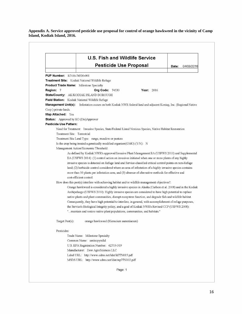
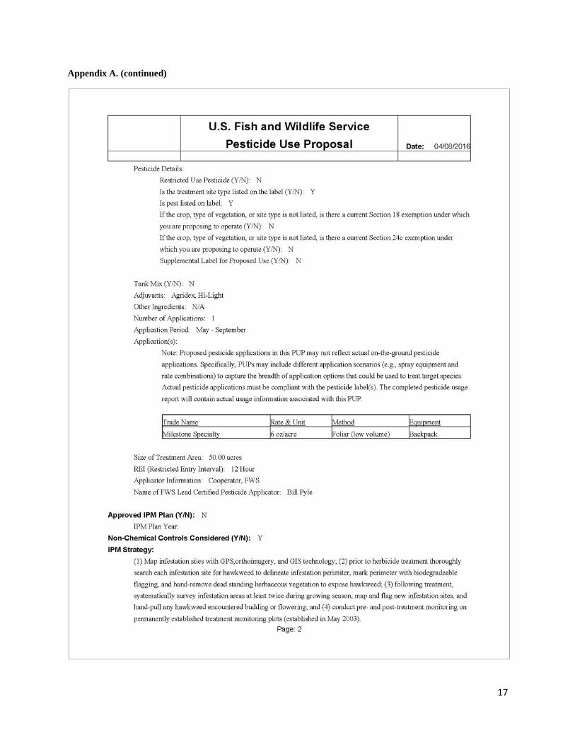
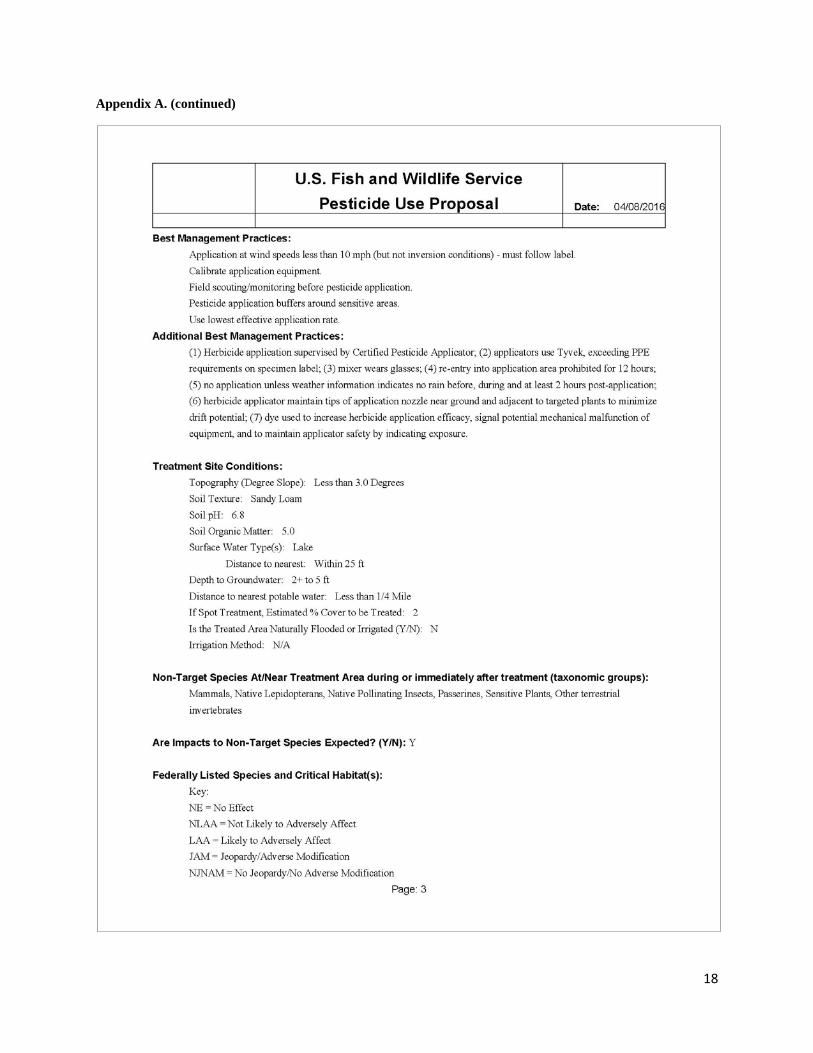
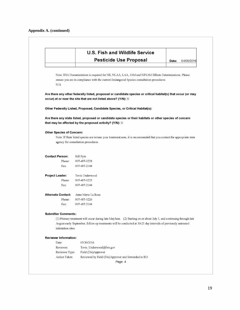
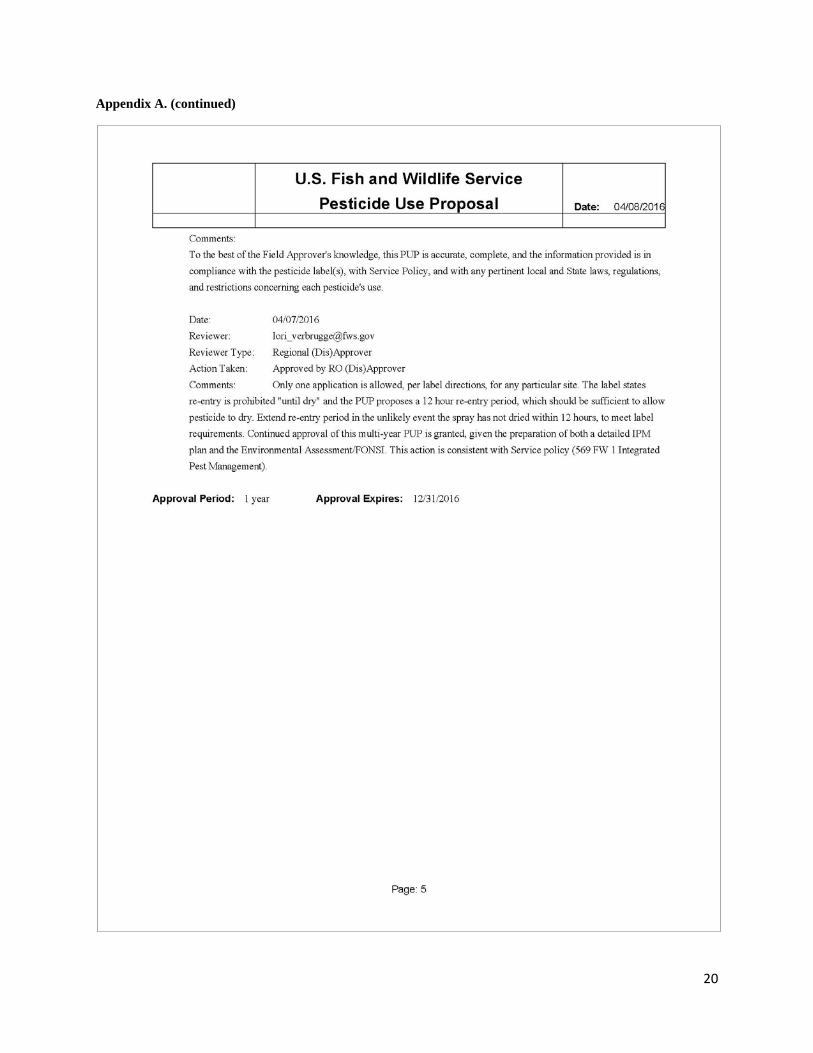
Herbicide Application A multi-year Pesticide Use Proposal (PUP) was prepared, peer-reviewed, and approved by the Service in April 2016 (Appendix A). The PUP detailed treatment area characteristics, IPM tactics and strategy, best management practices, supporting documents, and review/approval officials. Additionally, IPM actions involving the Service in the Kodiak area, including multi-jurisdictional lands and the project area, were programmatically addressed in an approved Environmental Assessment (USFWS 2010) and supplemental Environmental Assessment (USFWS 2014). As required by the Service, all herbicide applications were supervised by at least one Certified Pesticide Applicator (Pyle, Hernandez).
In general, we applied two tactics for IPM with herbicide in 2016. Selection of the monthly survey and treatment interval was based primarily on the need for sufficient time to elapse for both additional growth of hawkweed (e.g., seedlings grow to height where they may be visually detected) and for accurate assessment of hawkweed mortality in response to the most recent previous application. In no case was herbicide applied to a site where it was previously applied that year, as dictated by the herbicide label. The action of the herbicide facilitated accomplishment of this requirement because it killed plants whose foliage was sprayed and, because residual herbicide activity continued to kill any plants at the site of application for the remainder of the growing season.
Scheduling of application missions was based on the availability of crew, forecasted weather, phenology of hawkweed growth, and occurrence of previous within-year application missions. Applications were scheduled to coincide with forecasted dry weather and, on the day of application, following dissipation of morning dew, usually by 1100. In cases where wet weather was encountered, such as mid-August and mid-September 2016, herbicide application was deferred to the next mission. Prior to herbicide application, we selected a herbicide mixing site, the mixer donned personal protection equipment (i.e., rubber boots, nitrile gloves, Tyvek® coveralls, safety glasses); transported mixture components to this site; estimated total quantity of components needed; and formulated the mixture in standard 18 l (4 gal) backpack tanks and/or handheld quart-size spray bottles. Choice of application method (backpack, handheld bottle, or combination) was based mainly on estimated size of the job and number of available crew consisting of a minimum ratio of one applicator and one hawkweed spotter/bear guard. The initial May application was conducted after surveys were completed of historic infestation sites. Subsequent applications during June-September operated concurrent with the survey.
The herbicide formulation (i.e., tank mix) consisted of water, the main component; Milestone™, an aminopyralid-based herbicide; Agri-Dex®, a non-ionic water soluble spray adjuvant; and Hi-Light® blue, a water soluble dye. Whereas the adjuvant was included to improve deposition and retention of herbicide on hawkweed foliage, the dye displayed the location and volume of application, improved application accuracy, and increased application efficiency. Milestone was applied at a label-allowed rate of 0.29 ml/ha (6 oz/ac). Formulation of tank mix per 3.8 l (1 gal) of water consisted of 4.1 ml (0.1 fl oz), Milestone, 19 ml (0.6 fl oz) of Agri-Dex, and 15 ml (0.5 fl oz) of Hi-Light. Following preparation of the formulation, fieldworkers systematically navigated to active infestation sites marked on the field survey map, and applied the formulation

4
directly to exposed hawkweed foliage. The hawkweed spotter served key IPM functions including: safety monitoring for leaks and applicator exposure; navigation by map and GPS unit to infestation sites; searching for hawkweed at, and in the vicinity of, the GPS-recorded infestation site; ensuring thoroughness of the application, and recording progress of the application effort (e.g., hashmark made with sharpie pen on infestation site map). An application mission was considered complete when all active infestation sites had been treated. Following completion, application equipment and boots were cleaned with diluted dish soap in the mixing area, and Tyvek coveralls and gloves were bagged and transported to Kodiak for disposal.
Monitoring We applied standard methods for annual monitoring of response of hawkweed and native vegetation to IPM practices. These included repeat photography at photopoint sites; recurrent monthly survey of hawkweed occurrence (i.e., absent, present) at documented infestation sites; semi-annual monitoring of frequency of occurrence of hawkweed and native forb species at permanent plots; and evaluation of annual trend in volume of herbicide application and application area.
In late July-early August we re-photographed scenes at one of two sites originally photographed in late July 2002 before IPM was initiated in the Camp Island vicinity (Figure 1). Following conclusion of a survey, data acquired from each survey of infestation sites were inputted to a spreadsheet (MS Excel) back in the office. Before the next survey, a new field survey form was generated to display the most recent history of hawkweed occurrence at infestation sites. Assessment of current status was based on summary of occurrence records for a survey. Assessment of trend was based mainly on comparison among years of results from the last survey of the year.
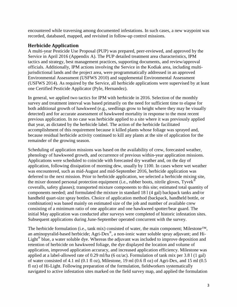
In accordance with procedures described in the 2014 report, we sampled plant taxa frequency of occurrence near start and peak of the annual growing season (e.g., mid-May, mid-July) at three treatment plots and one control plot established in May 2003 (Figure 1). In the office data were databased (MS Access) and processed to generate summary results.
For each application, we recorded the amount of applied herbicide on a standard form. In the office, usage data were entered into a spreadsheet, checked for accuracy, and analyzed to generate summary statistics such as total annual volume of active herbicide agent (i.e., aminopyralid) and total area of application.
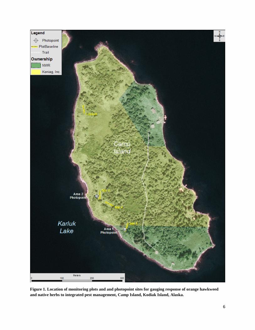
Results and Discussion We surveyed 37 ha (92 ac) of the Island Point vicinity in May but did not identify any new hawkweed infestations (Figure 2). Consequently the footprint of the total infestation did not change since 2015 (Figure 3). Herbicide was applied where hawkweed was observed at 9 of 22 historic infestation sites during May-June. No surveys or applications occurred on Koniag, Inc. land on Island Point during July-September.
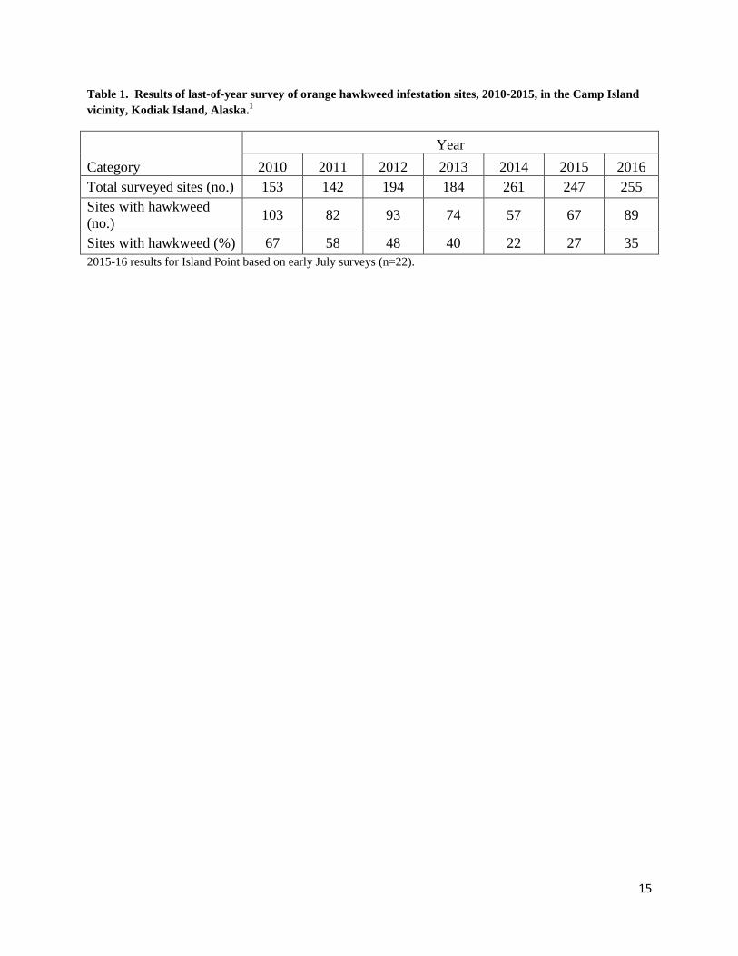
Comparison of September surveys indicated more infestations in 2016 (35%) than 2015 (27%), both of which were considerably greater than the low observed in 2014 (22%) (Table 1, Figure 4). This trend of recent increase is attributed simply to the missed survey and treatment of active infestation sites on Koniag, Inc. lands in August 2015. Moreover, it is highly likely that some of

5
the infestations treated in 2016 represented plants that established from seed disseminated in August 2015. This outcome underscores the importance of consistent adherence to the Refuge’s operation plan. In 2017 we expect fewer active infestations if the operation plan is fully implemented.
A total of 34 liters (9 gal) of herbicide formulation was applied to 0.08 ha (0.21 ac) of infestation sites in 2016. Total annual volume of active herbicide agent (i.e., aminopyralid) applied was 15.1 ml (0.51 fl. oz, equivalent to one tablespoon). Evaluation of trend indicated slight increase in annual usage in 2016 compared to 2015 (Figure 5). We attributed this increase to the increase in number of infestations in response to missed August 2015 surveys and applications as explained previously. Usage is expected to decline in 2017 if the full scope of planned survey and treatments is implemented.
Photopoint sites and plot-based monitoring was completed. Results from comparison of visual aspect of vegetation in 2002 and 2016 photopoint scenes is indicative of the magnitude of the original infestation and the extent of recovery of native vegetation, respectively (Figure 6 & 7).
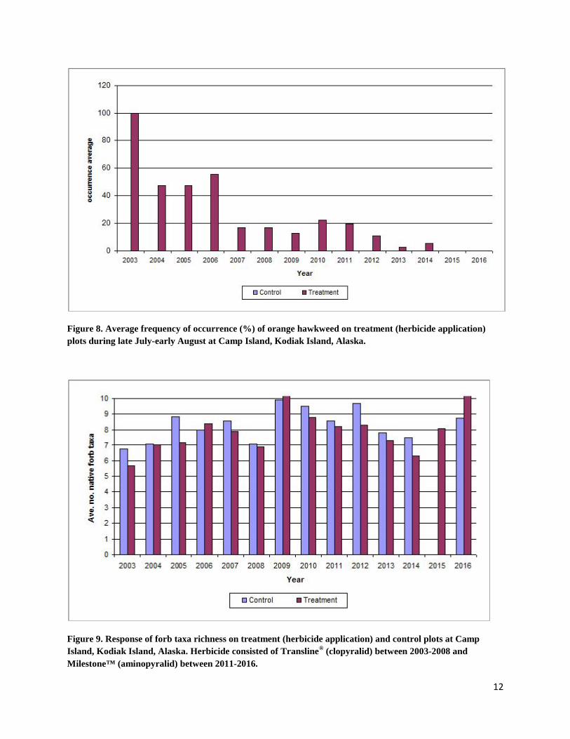
In 2016, no hawkweed was observed in permanent plots annually sampled since 2003 on Camp Island (Figure 8). Evaluation of trend revealed a major decrease in frequency during 2003-2009; a slight increase in response to temporary cessation of herbicide application in 2010; and gradual decline to trace levels exhibited during 2013-2014. This pattern of trend—major decline in hawkweed density in response to management—was supported by extensive field observations across the Camp Island area.
Since 2014, the last year of complete sampling, richness of forbs has markedly increased (Figure 9). Expectation is that richness will continue to vary between treatments and years; however, trend should generally exhibit a pattern of post-treatment increase followed stabilization indicative of recovery.
References [USFWS] U.S. Fish and Wildlife Service. 2010. Environmental assessment: Integrated pest
management of invasive plants on Kodiak National Wildlife Refuge. Kodiak, Alaska: U.S. Fish and Wildlife Service, Kodiak National Wildlife Refuge.
[USFWS] U.S. Fish and Wildlife Service. 2014. Supplemental environmental assessment: Integrated pest management of invasive plants on Kodiak National Wildlife Refuge. Kodiak, Alaska: U.S. Fish and Wildlife Service, Kodiak National Wildlife Refuge.
6
Figure 1. Location of monitoring plots and and photopoint sites for gauging response of orange hawkweed and native herbs to integrated pest management, Camp Island, Kodiak Island, Alaska.
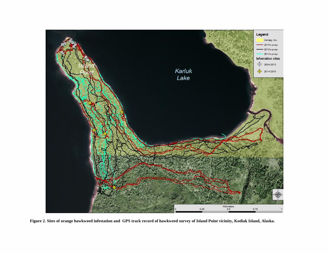
Figure 2. Sites of orange hawkweed infestation and GPS track record of hawkweed survey of Island Point vicinity, Kodiak Island, Alaska.
Figure 3. Known extent of orange hawkweed infestation 2003-2013 and 2014-2016 in the Camp Island vicinity of Kodiak Island, Alaska.

9
Figure 4. Status of orange hawkweed following four applications of herbicide between mid-May and late September 2016 at documented infestation sites in the Camp Island vicinity, Kodiak Island, Alaska. Note that herbicide was applied to hawkweed at sites labeled “present” in late September 2016.
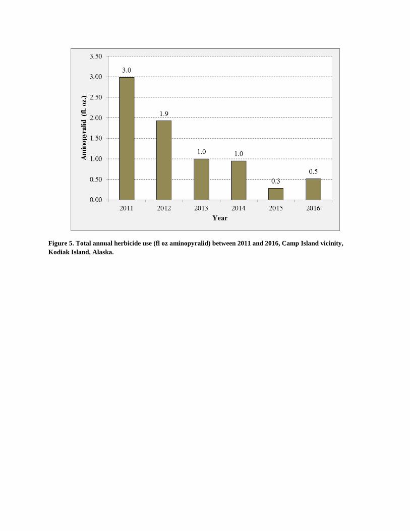
Figure 5. Total annual herbicide use (fl oz aminopyralid) between 2011 and 2016, Camp Island vicinity, Kodiak Island, Alaska.

11
Figure 6. Orange hawkweed infestation, photopoint site, W. Camp Island, Karluk Lake, July 2002.
Figure 7. Photo retake at scene in figure 8, July 2016. Note the extent of restoration of native plants compared to 2002.
12
Figure 8. Average frequency of occurrence (%) of orange hawkweed on treatment (herbicide application) plots during late July-early August at Camp Island, Kodiak Island, Alaska.
Figure 9. Response of forb taxa richness on treatment (herbicide application) and control plots at Camp Island, Kodiak Island, Alaska. Herbicide consisted of Transline® (clopyralid) between 2003-2008 and Milestone™ (aminopyralid) between 2011-2016.

13

14
15
Table 1. Results of last-of-year survey of orange hawkweed infestation sites, 2010-2015, in the Camp Island vicinity, Kodiak Island, Alaska.1
Category Year
2010 2011 2012 2013 2014 2015 2016 Total surveyed sites (no.) 153 142 194 184 261 247 255 Sites with hawkweed (no.) 103 82 93 74 57 67 89
Sites with hawkweed (%) 67 58 48 40 22 27 35 2015-16 results for Island Point based on early July surveys (n=22).
16
Appendix A. Service approved pesticide use proposal for control of orange hawkweed in the vicinity of Camp Island, Kodiak Island, 2016.
17
Appendix A. (continued)
18
Appendix A. (continued)
19
Appendix A. (continued)
20
Appendix A. (continued)