Embed Size (px)
Citation preview
autumn 2010
JoL AJ O U R N A L o f L A N D S C A P E A R C H I T E C T U R E
Regionalisation / Memorial Parks / J. B. Jackson / Five Years

6 Journal of Landscape Architecture / autumn 2010
“In its recognition of the region as a basic configuration in human life; in its acceptance of natural diversities as well as natural associations and uniformities; in its recognition of the region as a permanent shore of cul-tural influences and as a centre of economic activities, as well as an im-plicit geographic fact – here lies the vital common element in the region-alist movement. So far from being archaic and reactionary, regionalism belongs to the future.”(Lewis Mumford 1938: 306)
“The Great Lakes, with the immense resources and communications which make them a Nearctic Mediterranean, have a future, which its exponents claim may become world-metropolitan in its magnitude.”(Patrick Geddes 1915: 49)
“The Chicago press now urges that the depth of water in the [Great] lakes and the lake harbors should be regulated and maintained by a series of great dams. [...] This may be required if, to natural causes which re-duce the depth of water is to be added an outflow of 600,000 cubic feet per minute for the removal of Chicago’s sewage and the promotion of com-merce on a ship canal through the State of Illinois. The public should un-derstand what the situation is, for we shall hear more about these projects. [...] Canada, as well as [the United States], has a considerable interest in them.” (The New York Times 1897: 12)
Abstract Over 40 million people live within the watershed region of the Great Lakes in North America, the largest body of fresh water on the planet. During the past two centuries the region has been given a series of idiosyncratic designations such as the Great Cutover, the Manufacturing Belt, the Rust Belt, the Great Lakes Megalopolis and the Megaregion by well-known ur-banists from Patrick Geddes to Jean Gottmann. Emblematic of different processes of colonisation, industrialisation and urbanisation, these histor-ical characterisations reveal a landscape of geo-economic significance be-yond the conventional limits of the city while testifying to a deeper ontol-ogy of regionalist canons whose focus is the hydrophysical system of the Great Lakes. Referencing a series of overlooked plans, projects and proc-esses, this essay demonstrates how the Great Lakes Region is a macrocosm of change, a case study in the urban transformation of the continent with relevance to other parts of the industrialised world such as France, Ger-many, Britain, Italy, Russia, Japan and Australia. As a revival of the revo-lutionary régionalisme of Jean Charles-Brun in late 19th-century France and as a challenge to contested globalisation identified by Saskia Sassen at the end of the 20th century, this essay proposes that the regionalisation of ecological, economic and political conditions is of crucial significance to the global discourse on urbanisation.
Landscape / regionalism / ecology / urbanism / Great Lakes
Pierre Bélanger, Harvard University graduate school of design, Usa
Regionalisation:Probing the urban landscape of the Great Lakes Region
7Journal of Landscape Architecture / autumn 2010
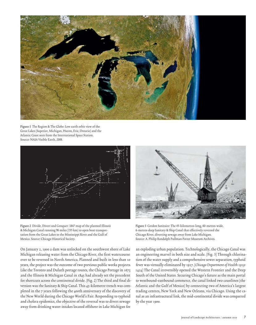
On January 2, 1900 a dam was unlocked on the southwest shore of Lake Michigan releasing water from the Chicago River, the first watercourse ever to be reversed in North America. Planned and built in less than 10 years, the project was the outcome of two previous public works projects. Like the Toronto and Duluth portage routes, the Chicago Portage in 1673 and the Illinois & Michigan Canal in 1845 had already set the precedent for shortcuts across the continental divide. (Fig. 2) The third and final di-version was the Sanitary & Ship Canal. This 45-kilometre trench was com-pleted in the 7 years following the 400th anniversary of the discovery of the New World during the Chicago World's Fair. Responding to typhoid and cholera epidemics, the objective of the reversal was to divert sewage away from drinking water intakes located offshore in Lake Michigan for
Figure 1 The Region & The Globe: Low earth orbit view of the Great Lakes (Superior, Michigan, Huron, Erie, Ontario) and the Atlantic Coast seen from the International Space Station. Source: NASA Visible Earth, 2008.
an exploding urban population. Technologically, the Chicago Canal was an engineering marvel in both size and scale. (Fig. 3) Through chlorina-tion of the water supply and a comprehensive sewer separation, typhoid fever was virtually eliminated by 1917. (Chicago Department of Health 1919: 1424) The Canal irreversibly opened the Western Frontier and the Deep South of the United States. Securing Chicago’s future as the main portal to westbound-eastbound commerce, the canal linked two coastlines (the Atlantic and the Gulf of Mexico) by connecting two of America’s largest trading centres, New York and New Orleans, via Chicago. Using the ca-nal as an infrastructural link, the mid-continental divide was conquered by the year 1900.
Figure 2 Divide, Divert and Conquer: 1847 map of the planned Illinois & Michigan Canal running 96 miles (155 km) to open boat transpor-tation from the Great Lakes to the Mississippi River and the Gulf of Mexico. Source: Chicago Historical Society.
Figure 3 Cordon Sanitaire: The 45-kilometres-long, 60-metres-wide, 6-metres-deep Sanitary & Ship Canal that effectively reversed the Chicago River, diverting sewage away from Lake Michigan. Source: A. Philip Randolph Pullman Porter Museum Archives.

8 Journal of Landscape Architecture / autumn 2010
Regionalisation : Probing the urban landscape of the Great Lakes Region Pierre Bélanger
The diversion focused a wide and contentious lens on the urban pressures, the physiographic magnitudes, the hydrologic complexities and the juris-dictional constituencies of the region. The conflicts, confrontations and crises that originated with the Sanitary & Ship Canal also laid the ground-work for a history of other water diversions, extractions and abstractions up to the present day. Pre-dated by water works across the Great Lakes such as the Erie Canal and Ohio Canal Systems in the 19th century, fol-lowed by other mega-projects like the Niagara Falls hydroelectric dam and the St. Lawrence Seaway in the 20th century, the reversal of the Chicago River can be interpreted as a turning point in North American water man-agement. Technologically, the diversion displayed the prowess of civil en-gineering in one of the most important public works projects of the 20th century. (APWA 2000) Leading to the formation of the Chicago School of Earthmoving, it set the precedent for other construction projects such as the Panama Canal.
The reversal of the Chicago River also marks a major moment in the re-gionalisation – an operative term that designates the geographic, economic and ecological process of characterising and forming regions according to overlapping geopolitical and biophysical boundaries – of the Great Lakes. Whereas in the past each lake was perceived as one of a series of loosely connected water bodies, a major change occurred in the understanding of their interconnectedness. The politics of the diversion later resulted in the milestone enactment of the Boundary Waters Treaty in 1909 (Quinn 1988), soon followed by the inception of the International Joint Commission (IJC), a cross-border organisation exclusively mandated to help resolve disputes and to prevent future ones, primarily those concerning water quantity and water quality along the boundary between Canada and the United States. More than a century later, the IJC has grown in size and influence to be-come a model of transnational cooperation and watershed governance, rec-ognised worldwide. Paradoxically, the making of a simple water channel revealed the pre-eminence of the region and how it functions as an essen-tial urban infrastructure that binds cities to their watersheds.
Reversal of the Chicago River precipitated another important effect. Chan-nelled away from the Llake, sewage poured downstream into the Illinois River towards the Mississippi by way of St. Louis. Locally, complaints from downstream residents in Southwest Chicago were almost immediate. As the sewage moved further downstream across state lines, so did the back-lash. Regionally, St. Louis engaged in a bitter legal battle over pollution well before canal construction started in 1892. While sewage overloading played a role, the major case focused on the excessive shipping traffic from Chicago to the Mississippi originating from a city outside the river basin. Geopolitically, the reversal of the river imposed external effects on resi-dents in the valley of the Illinois River. Although injunctions submitted by the State of Missouri to halt the reversal were rejected by the Supreme Court, limits on water diversion were eventually enacted by 1925. (Chang-non and Harper 1994: 16B38) In the decade-long process, the proceedings made visible the downstream effects of upstream urbanisation. Geopoliti-cally, it could be deduced that the effects of cities lie well beyond the gov-erning limits of the city itself, and that the source of historical conflicts often flows from the discrepancies, or differentials, between biophysical systems across man-made political boundaries.
Less than a quarter-century after its construction, the Chicago diver-sion had other unplanned consequences: water levels throughout the Great Lakes were dropping at visible rates. International conflict was imminent. Ten thousand cubic feet of water per second was being diverted from Lake Michigan, rousing concerns as far away as Eastern Ontario, the Canadian neighbour to the north that consistently opposed any freshwater diver-sions from the Great Lakes. Bordering on four of the five Great Lakes, the Province of Ontario was losing more than 300,000 cubic feet of water per minute from the diversion, a significant loss for the hydroelectric dam at Niagara Falls. Two more diversions and two more reversals would be con-structed on Lake Michigan in less than a quarter-century. Chicago headed straight ahead for a 100-year battle over water rights. The State of Missouri joined forces with Wisconsin, Michigan and New York in a coalition to put an end to the diversions.
Figure 4 Land Economics: Logging blocks in Northern Wisconsin in the region that became known as the Great Cutover during the late 19th century. Source: Board of Regents of the University of Wisconsin System.T
AY
LO
R B
RO
TH
ER
S

9Journal of Landscape Architecture / autumn 2010
between 1890 and 1920. Historically recognised as the Great Lakes Cutover, the region served as the hinterland of modern commercial centres such as Boston, New York, Philadelphia and Washington. Without any formal plans for reforestation, the devastation of forests resulted in the ongoing westward march in the late 19th century that left in its wake a landscape of stumps, swamps, and scoured fields. With land rendered useless from a logging perspective, a group of conservationists, planners and industrial-ists emerged to develop strategies for the re-utilisation of these razed areas.
One of the most notable proponents was Benton Mackaye, a renowned forester and pioneer of the U.S. conservation movement. (Sutter 1999) Recog-nised for his conception of the Appalachian Trail on the East Coast, Mackaye drew up reclamation diagrams for the Department of Labor and the Forest Service in the early decades of the 20th century. He was exploring new re-gional economic geographies in Minnesota and Wisconsin bordering Lake Superior. Influenced by Gifford Pinchot from the U.S. Forest Service and Michigan conservationist P.S. Lovejoy, Mackaye deplored the idle, unpro-ductive waste of more than ten million acres of cutover lands in Michigan. As observed by Lovejoy in his critical survey of the Cutover Michigan’s Mil-lions of Idle Acres, the crisis was essentially agricultural. (Lovejoy 1920) Soils were either too wet or too infertile to turn a profit with crop farming; or too shallow for crop cultivation or rotation swamped by naturally rising water tables after clear cut logging. (Kates 2001) Once a great timber pro-ducer, the Great Lakes state became a net importer: home-grown hemlock was outcompeted by fir from the West, hickory from the East and oak from the South. Mackaye’s strategies reconceived the landscape of the failed ag-ricultural experiments of the Northern Wisconsin region and several other cutover regions in the Northwest United States. Borrowing from the pro-totypes of woodland settlements published by the Canadian Commission on Conservation, Mackaye and Lovejoy foresaw imminent urbanisation by sketching out regional reclamation diagrams that coupled reforestation with repopulation. (Fig. 5) As a countermeasure to careless, frontier land development in the 19th century, their work pioneered renewable econo-mies of conservation areas, selective logging zones and village settlements.
The Great Cutover and the contours of conservation Like the construction of the Calumet-Saganashkee and North Shore Chan-nels a few years later, the reversal of the Chicago River was a response to un-foreseen population explosion in the Great Lakes cities as a transit node be-tween the urban markets on the Atlantic Coast and the Grain Belt of the Prairies; lucrative logging and mining industries were attracting Europe-ans seeking to escape food shortages, oppressive taxes and wars (Fig. 4) to Chicago as the gateway to the Western Frontier. Revolutionary farm tools such as the McCormick mechanical reaper, the Baker wind engine and the John Deere steel plough (Collins 1990; McGrath 1999) were invented through-out the Midwest in what became a golden age of agricultural innovation. But immigrants soon encountered a reoccurence of their European plight of density and disease. With the rise of steam navigation, canal construction, rail transport and cross-continental mobility, the birth of the pre-Civil War commercial metropolis and the rise of the 19th-century industrial factory town led to an explosion of urban population followed by a concurrent ru-ral vacuum. Chicago’s population, for example, jumped from 5,000 in 1840 to over 1.5 million in 1900. (Mohl 1997) In the absence of an integrated water in-frastructure, sewage disposal in Lake Michigan polluted fresh water supplies. The diversion of sewage away from the lake through the Sanitary & Ship Ca-nal was the simplest and most logical solution. With a battery of concurrent farm drainage programmes and land reclamation acts in outlying areas, the super-urbanisation [1] of Chicago became synonymous with renegade trade generated from the industries of mass logging and mass mining. From mass industrialisation across the region there emerged a series of proto-conserva-tion groups who would shape the future of urbanisation.
Harvest and heistFollowing the clear-cut logging and slash fires in the virgin forest regions of the Midwestern United States and central Canada, a massive reclamation project took place. From Northern Michigan to Southwestern Ontario, ram-pant clear-cutting of hardwoods (oak, maple, birch) and softwoods (white pine, spruce) stripped bare over 65 percent of the 40 million northern acres of choice timber in Wisconsin, Minnesota, Michigan, Ohio and New York
Figure 5 Regional Pre-Planning: 1911 resettlement diagram of Cutover lands by Benton Mackaye for the U.S. Forest Service of the northern portion of Minnesota and Wisconsin. Source: The Papers of Benton Mackaye, Dartmouth College Library.

10 Journal of Landscape Architecture / autumn 2010
Reclamation and reconstructionWith the groundwork laid by Mackaye and Lovejoy, developments in land planning evolved into the research of Richard T. Ely, a German-trained reform economist from the University of Wisconsin. With his large-scale perspective on the challenges of land settlements, Ely formulated meth-ods of effective land utilisation based on regional forest economics, argu-ing for a more consolidated understanding of the Cutover Region. Disfa-vouring the uncoordinated efforts of greedy land hustlers and reckless farmers, Ely theorised strategies that synthesised the imperatives of land conditions and urban economies. Those innovations later took shape dur-ing the 1940s in a book entitled Land Economics. Leading to the birth of a new field, this publication exhaustively articulated an alternative ap-proach to the development of land. Different from land planning or real estate development, land economics was a hybrid discipline drawing on economics, politics and agriculture. It was based on a regional perspective for the effective reorganisation and reuse of land over long periods of time rooted in the pre-existence of resources and the future of urban settle-ments. Relying on the empirical understanding of biophysical resources as economic structure (Fig. 6), Ely’s work was premised on bringing urban longevity to the Cutover Region. (Ely and Wehrwein 1940) Using a regional lens, Ely established the foundations for the reorganisation of land, show-ing where a new geo-economic structure could be achieved through col-lective models of governance that privileged the integration of hydrologi-cal systems, regional cooperation and state legislation.
Landscape economicsFounder of the American Economic Association and bullish proponent of labour organisations and the public management of resources, Ely prem-ised his work on the advantage that groundwater resources and surface watersheds offered replenishable capital. (Rabinowitz 2004: 109) In the Cu-tover Region, Ely promoted the de-zoning of land – rather than the set-tling of it – taking it out of urban or industrial use for public forestry practices. Ely mapped out land uses as directly generated from soil types, microclimates and water resources that were primarily agrarian. In his view, collective farsighted reclamation of land had to supplant the near-sighted renegade efforts of private landowners. It was no coincidence that in the 1940s Frank Lloyd Wright – a Prairie School architect from the Mid-west – would simultaneously unveil an intricately detailed scale model representing a hypothetical four-square-mile community proposal for the denuded landscape of rural Illinois. Aptly named Broadacre City, the model experimented with a unique Midwestern structure where hydrology and topography pre-figured as primary infrastructures amidst an expansive field of agriculture, housing and civic services. (Cucci 1979) (Fig. 7) Con-ceived at his Taliesin studio in Spring Green, Wisconsin, 150 miles west from Chicago, Wright’s urban-agrarian proposal was largely an antithesis of the European concept of the centralised industrial city. Almost two dec-ades later, parallel to the land policy objectives of Richard Ely and the re-gional strategies of Benton Mackaye, Wright as an architect/urbanist dis-tilled the essence of the Midwestern land challenge in his 1958 manifesto Living City, proclaiming, “We should have a system of economics that is structure … that is organic tools”. (Wright 1958: 162) Looking beyond the
Figure 6 Economic Geography: Map of productive regions of the United States and Canada as a synthesis of agricultural and political divisions in North America. Source: ©Land Economics, 1940.
Regionalisation : Probing the urban landscape of the Great Lakes Region Pierre Bélanger

11Journal of Landscape Architecture / autumn 2010
city, they all sought to escape conventional forms of conservation without reverting to pro-rural isolationism or anti-urban pastoralism. (Robinson 2005; Wright 1941) While their work remained reactive to existing condi-tions, they opened a broader prospect of the region as a design territo-ry, capable of engaging more diversified processes at larger scales, across longer periods of time. For them, in practice and in theory, the region was becoming the medium.
Globalisation and the corrosion of the Manufacturing Belt Before and during the World Wars, the Great Lakes states underwent con-siderable growth in the areas of steel production, chemical processing, weapons manufacturing and automobile production. The abundance of iron ore, coal and electricity along with vast fresh water resources and navigable waterways fed the development of large factory towns in the region of the Great Lakes and industrial metropolises of the Northeast-ern Seaboard. With an abundance of farm and factory labour the region of the Great Lakes, especially near the Midwest, became a frontier of boom-towns. (Meyer 1983) Large, centralised, heavy industry facilities developed at a rapid pace to secure the region’s international reputation as the Man-ufacturing Belt.
Where timber and transportation had dominated the previous century, the discovery of iron-bearing taconite in Minnesota’s Mesabi Range fuelled the industrial engine of the Manufacturing Belt. By World War I, Minnesota was meeting two-thirds of U.S. demand for iron ore. (Hall 1997) A geography of extraction, processing and distribution emerged. Vast sup-
plies of ore were shipped by rail and by ship from Duluth at the western extremity of Lake Superior and moved eastward to steel mills in the lower Great Lakes near vast supplies of Appalachian coal. Finally, long and flat steel for product manufacturing or construction projects made its way by rail to growing urban centres on the Atlantic Coast. (Time 1952) From this geographic network rose an industrial shed that was underpinned by the geophysical landscape of the Great Lakes. City appellations signified their might: Pittsburgh the Steel City, Sudbury the Nickel City, Hamilton the Steel Town, Sarnia the Chemical Valley, Detroit the Motor City, Cleveland the Bridge City, Toledo the Glass City, Buffalo the City of Light, Milwau-kee Supplier to the World. (Fig. 8)
Deindustrialisation and decentralisationA few decades later, after a relatively short-lived peak in production fol-lowing the World Wars, industrial growth plummeted. The U.S. steel in-dustry workforce fell from 509,000 to 240,000 between 1973 and 1983. Out-sourced production, rising energy prices and increasing trade deficits all contributed to manufacturing’s demise and the abandonment of heavy industry. From Wisconsin to Upstate New York, the widespread pattern of deindustrialisation had incendiary effects including the decentralisa-tion of city centres. (Garreau 1981) What was once admired worldwide as the U.S. Manufacturing Belt became universally known as the Rust Belt. (Jacobs 1970) Burdened by large, overbuilt structures and public works dis-investment, this massive economic shift precipitated the erosion of pub-lic infrastructures. America’s public facilities were wearing out faster than
Figure 7 Agrarian Urbanisation: Layout view of Frank Lloyd Wright’s Broadacre City representing a decentralised Midwestern structure of urban land settlement in the 1940s. Source: ©The Living City, 1958.
Figure 8 Rise and Fall of a Great American City: Dubbed ‘The Machine Shop of the World’, Milwaukee owed its rise to the industries of machinery, meats and malts that flourished after the Civil War but declined after the Great Depression. Source: Courtesy of Milwaukee Public Library and Department of City Development, Society for Industrial Archeology (1901).

12 Journal of Landscape Architecture / autumn 2010
Disurbanism and disassemblyThe economic fallout further precipitated the population vacuums of in-ner cities and former company towns in the Rust Belt from the 1950s on-ward. Cities were left the victims of decaying oversized infrastructure, contaminated vacant land, heavy tax burdens and social attrition. Despite good intentions – copious amounts of money were poured into urban re-newal projects such as new stadiums or convention centres in Detroit, Flint, Milwaukee and Buffalo – little has improved the economic circum-stances. (Glaeser 2007) Milwaukee for example now has twice as many mur-ders as Los Angeles. Buffalo has double the taxes of New York City, and Flint has the third highest crime rate in the nation. General Motors CEO Roger Smith closed down all the assembly plants in Flint, leaving over 40,000 people jobless and the entire city virtually bankrupt in the 1980s. Since then, city mayors have been toying with tourism as a substitute for urban economic regeneration and environmental reconstruction. Down-town Flint has seen its share of big city ideas: a 13 million-dollar Hyatt Re-gency Hotel and a 100 million-dollar AutoWorld theme park were rolled out to arrest decline but failed to jumpstart local economies. (see Michael Moore's documentary, Roger & Me, 1989) Reduced to junk bond status, the generic landscape of GM’s assembly plants is like the rest of the city, va-cant and abandoned on the overgrown banks of the Flint River. (Danda-neau 1996; Harvey 1996) As the sun has set on this disurbanising landscape, [2] decline and neglect seem to have become the progenitors of ecological regeneration, displaying the latency of biophysical dynamics that existed before industry. (LeDuff 2009)
they were being replaced. (Choate and Walter 1983) From decaying sewers to bridge collapses, incidents across the region were indicative of liber-al programmes of deregulation, deferred maintenance and delayed con-struction that exacerbated urban disaggregation and the hollowing out of inner city cores.
The decline of the Rust Belt in the second half of the 20th century mainly stemmed from six factors: the global mobility of corporations, the attrition of innovation, the inflexible demands of labour associations, the displacement of workers to new sectors of defence, oil, and aerospace in the Sun Belt, and an aging work force. Policies for the globalisation of the region and deregulation of national trade began with the Gener-al Agreement on Tariff and Trade in 1946, grew with the North American Free Trade Agreement (NAFTA) in 1994 and matured with the formation of the World Trade Organisation in 1995. Transnational trading policies opened international borders southward and westward where labour and raw materials were cheaper and environmental laws less stringent. As a result of global outsourcing (Friedman 2005), plant relocations led to in-dustrial disincorporation, further leading to land un-development, pop-ulation unemployment and de-urbanisation throughout the Great Lakes cities. In stark resemblance to Henry Ford’s premonition of industrial de-concentration in the Northeast (Ford 1922: 192), boomtowns became ghost towns while abroad, relocating industry found surrogate cities: Bangkok supplanted Detroit, Shanghai supplanted Cleveland, Taipei supplanted Toledo, and Mexico City supplanted Milwaukee. (Jones 2004)
Figure 9 Aquatic Bio-Indicator: Brown bullhead from Wisconsin’s Fox River with lip tumours demonstrating the presence of aromatic hydro carbons used for dyes, pharmaceuticals and agro-chemicals, which are known carcinogens. Source: National Geographic, 1974.
Figure 10 Crisis as Catalyst: Aerial view of the Humber River in Woodbridge during Hurricane Hazel in November 1954, subsequently leading to the Conservation Authorities Act. Source: National Library & Archives of Canada.
Regionalisation : Probing the urban landscape of the Great Lakes Region Pierre Bélanger
13Journal of Landscape Architecture / autumn 2010
torically, a pattern of ground and water contamination could no longer be ignored nor treated separately as it was before. It was now being un-derstood regionally as a new systemic understanding of the effects of in-dustrialisation emerged.
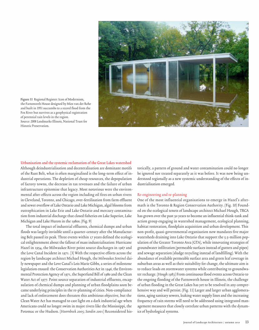
Re-engineering and re-planningOne of the most influential organisations to emerge in Hazel’s after-math is the Toronto & Region Conservation Authority. (Fig. 10) Found-ed on the ecological tenets of landscape architect Michael Hough, TRCA has grown over the past 50 years to become an influential think-tank and action group engaging in watershed management, ecological planning, habitat restoration, floodplain acquisition and urban development. This non-profit, quasi-governmental organisation now mandates five major watersheds draining into Lake Ontario that support the 5.5-million pop-ulation of the Greater Toronto Area (GTA), while innovating strategies of groundwater infiltration (permeable surfaces instead of gutters and pipes) and sewage separation (sludge recycling instead of landfilling). With the abundance of available permeable surface area and green leaf coverage in suburban areas as well as their suitability for change, the ultimate aim is to reduce loads on stormwater systems while contributing to groundwa-ter recharge. (Hough 1983) From continuous flood events across Ontario to the ongoing flooding of the Farnsworth house in Illinois, the challenge of urban flooding in the Great Lakes has yet to be resolved in any compre-hensive way and will persist. (Fig. 11) Larger and larger urban agglomera-tions, aging sanitary sewers, leaking water supply lines and the increasing frequency of rain storms will need to be addressed using integrated man-agement measures that closely correlate urban patterns with the dynam-ics of hydrological systems.
Urbanisation and the systemic reclamation of the Great Lakes watershedAlthough deindustrialisation and decentralisation are dominant motifs of the Rust Belt, what is often marginalised is the long-term effect of in-dustrial operations. The depletion of cheap resources, the depopulation of factory towns, the decrease in tax revenues and the failure of urban infrastructure epitomise that legacy. Most notorious were the environ-mental after-effects across the region including oil fires on urban rivers in Cleveland, Toronto, and Chicago, over-fertilisation from farm effluent and sewer overflow of Lake Ontario and Lake Michigan, algal blooms from eutrophication in Lake Erie and Lake Ontario and mercury contamina-tion from industrial discharge that closed fisheries on Lake Superior, Lake Michigan and Lake Huron in the 1980s. (Fig. 9)
The total impact of industrial effluents, chemical dumps and urban floods was largely invisible until a quarter-century after the Manufactur-ing Belt passed its peak. Three events within 17 years defined the ecologi-cal enlightenment about the fallout of mass industrialisation: Hurricane Hazel in 1954, the Milwaukee River point source discharges in 1967 and the Love Canal Incident in 1971. [3] With the respective efforts across the region by landscape architect Michael Hough, the Milwaukee Sentinel dai-ly newspaper and the Love Canal’s Lois Marie Gibbs, a series of milestone legislation ensued: the Conservation Authorities Act in 1946, the Environ-mental Protection Agency of 1971, the Superfund Bill of 1980 and the Clean Water Act of 1977. Point source separation of industrial effluents, encap-sulation of chemical dumps and planning of urban floodplains soon be-came underlying principles in the re-planning of cities. Non-compliance and lack of enforcement does threaten this ambitious objective, but the Clean Water Act has managed to cast light on a dark industrial age when Americans could no longer swim in major rivers like the Mississippi, the Potomac or the Hudson. (Hoornbeek 2005; Sandin 2001) Reconsidered his-
Figure 11 Regional Register: Icon of Modernism, the Farnsworth House designed by Mies van der Rohe and built in 1951 succumbs to a record flood from the Fox River but survives as a geophysical registration of perennial rain levels in the region. Source: 2008 Landmarks Illinois, National Trust for Historic Preservation.

14 Journal of Landscape Architecture / autumn 2010
Reclamation and remediationAddressing the divide between economy and ecology, a massive remedi-ation programme in the Great Lakes Region was spearheaded by the In-ternational Joint Commission in the late 1980s, addressing the impacts of discharges and diversions, floods and droughts and contamination and cleaning. With its mandate to advise on the use and quality of bound-ary waters in Canada and the United States, the Commission addressed three of the most pressing challenges in the Great Lakes: combined sew-er overflow, nutrient overloading and sediment contamination. Redress-ing the historical legacy of shoreline industries, the purpose is to reclaim the “chemical, physical, and biological integrity of the waters of the Great Lakes Basin Ecosystem.” As the principal source of contamination in Great Lakes rivers and harbours, polluted sediment created by decades of in-dustrial and municipal discharges has historically limited remediation and redevelopment efforts by virtue of its geographic magnitude. (Ducks Unlimited Canada 2009) The IJC has since initiated a massive cleanup pro-gramme with remedial action plans for 43 priority sites throughout the region. The bi-national programme uses multilateral funding and cross-border legislation to accelerate cleanup and redevelopment of the most contaminated sites, mostly harbours, in the downstream region. (Envi-ronment Canada 1999) Since bioremediation alone cannot solve the chal-lenge of brownfield redevelopment, the effect of new integrated regional economies offers a significant model for the reuse of land. At this scale, re-mediation costs can be offset by overall returns from productive land re-development across multiple sites. For the first time in the history of the Great Lakes, the collective objective of an economy based on clean fresh water has become a public regional imperative. There is a contemporary urbanisation of waterfronts in the Great Lakes at the turn of the 21st cen-tury and cities such as Chicago, Toronto, Hamilton, Sudbury and Detroit are in the vanguard. Public works projects by Kathryn Gustafson and Piet Oudolf in Chicago or by Field Operations, West 8 and MVVA in Toronto can be seen as the inception of a systemic, regional reclamation project in its infancy. [4] Its economy is its ecology.
Sub-urbanisation and super-urbanisation of the Great Lakes conurbationHorizontal spread and peripheral expansion remain the predominant forces that restructure towns and cities across the Great Lakes, but cit-ing depopulation and outmigration from city centres as the only causes of economic decline during the second half of the 20th century is flawed. Nationally, population statistics show that while the population of the U.S. was increasing, the Great Lakes region remained nearly constant with just 1 percent growth. (Great Lakes Information Network 2009) What really occurred was regional population dispersion through inner city exodus.
Culturally and economically diverse metropolitan areas such as Chi-cago and Toronto kept growing, but mostly on their peripheries. Access to a multitude of urban, public and high-quality services –education, mass transit and medical health care – supported by essential infrastructures including waste management, water, food, transport and energy provi-sion made big cities particularly attractive to a younger, knowledge-ori-ented generation. The transition from an industrial economy to an urban economy also involved a shift from mass production and heavy equip-ment to light manufacturing and lean inventories reliant on just-in-time logistics. (Waldheim and Berger 2009) Large centralised industries of macro-production made way for a distributed pattern of micro-production re-quiring new land uses and public services.
The only logical course of action for nearby factory towns was to down-size. Regionalising their services, distributing densities, and tapping larg-er urban economies became possible. Youngstown mayor Jay Williams has been testing the potential outcome of downsizing in Ohio. With plant shutdowns by Republic Steel and Youngstown Sheet & Tube Company over the past twenty years, the city is facing major fiscal deficits inher-ited from oversized infrastructure, abandoned properties and countless miles of asphalt roads to maintain. Derelict buildings are being razed, un-derground utilities cut off, lands banked, and industrial districts rezoned, back taxes are exchanged for land stewardship and roads are ripped up or blocked out. Remaining lands are amalgamated for agrarian, parkland or water uses. Former industrial land uses are overlaid with new produc-tive functions, bypassing the traditional re-zoning process. Counter strat-
Regionalisation : Probing the urban landscape of the Great Lakes Region Pierre Bélanger
15Journal of Landscape Architecture / autumn 2010
egies are modest but effective. The Mahoning River was once the sewer of Youngstown’s steel mills; now it serves as the backbone of an emerging corridor of light and medium-sized manufacturing enterprises.
Echoing Ely’s approach to land economics, Williams’s urban decom-missioning strategy suggests a general process of de-densification where the redistribution of land, industry and business can ultimately reduce tax burdens on citizens and maintenance burdens on the public works department. “Instead of capturing its industrial past, Youngstown hopes to capitalise on its high vacancy rates and underused public spaces to be-come a thriving bedroom community serving Cleveland and Pittsburgh, both of which are 70 miles away.” (Lanks 2006) Suburbanisation may be Youngstown's imperative.
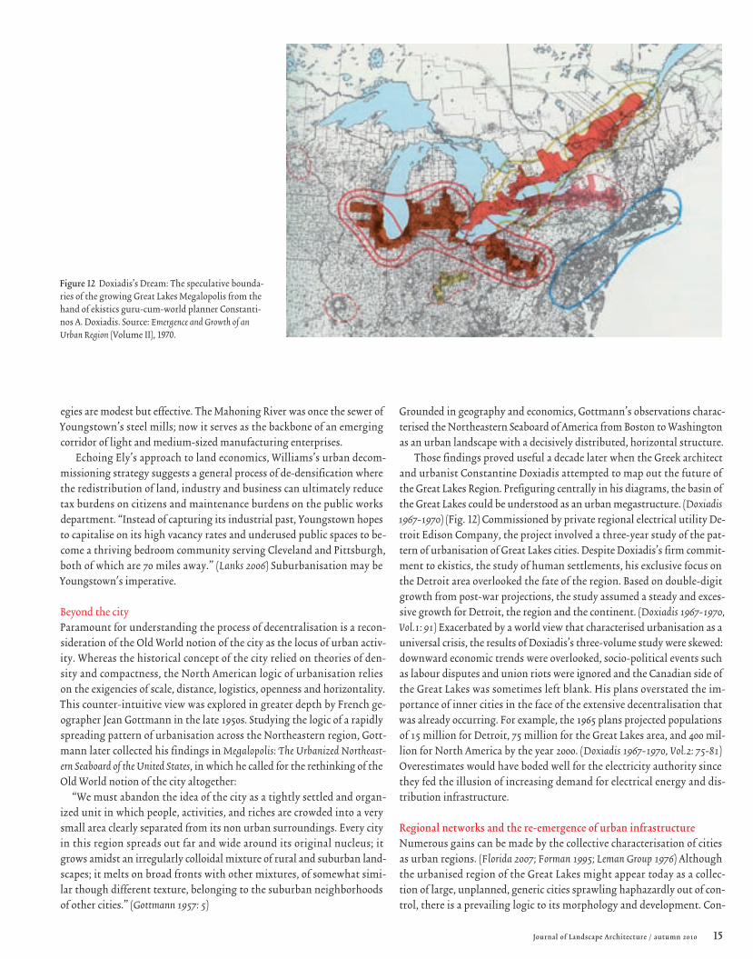
Beyond the cityParamount for understanding the process of decentralisation is a recon-sideration of the Old World notion of the city as the locus of urban activ-ity. Whereas the historical concept of the city relied on theories of den-sity and compactness, the North American logic of urbanisation relies on the exigencies of scale, distance, logistics, openness and horizontality. This counter-intuitive view was explored in greater depth by French ge-ographer Jean Gottmann in the late 1950s. Studying the logic of a rapidly spreading pattern of urbanisation across the Northeastern region, Gott-mann later collected his findings in Megalopolis: The Urbanized Northeast-ern Seaboard of the United States, in which he called for the rethinking of the Old World notion of the city altogether:
“We must abandon the idea of the city as a tightly settled and organ-ized unit in which people, activities, and riches are crowded into a very small area clearly separated from its non urban surroundings. Every city in this region spreads out far and wide around its original nucleus; it grows amidst an irregularly colloidal mixture of rural and suburban land-scapes; it melts on broad fronts with other mixtures, of somewhat simi-lar though different texture, belonging to the suburban neighborhoods of other cities.” (Gottmann 1957: 5)
Grounded in geography and economics, Gottmann’s observations charac-terised the Northeastern Seaboard of America from Boston to Washington as an urban landscape with a decisively distributed, horizontal structure.
Those findings proved useful a decade later when the Greek architect and urbanist Constantine Doxiadis attempted to map out the future of the Great Lakes Region. Prefiguring centrally in his diagrams, the basin of the Great Lakes could be understood as an urban megastructure. (Doxiadis 1967-1970) (Fig. 12) Commissioned by private regional electrical utility De-troit Edison Company, the project involved a three-year study of the pat-tern of urbanisation of Great Lakes cities. Despite Doxiadis’s firm commit-ment to ekistics, the study of human settlements, his exclusive focus on the Detroit area overlooked the fate of the region. Based on double-digit growth from post-war projections, the study assumed a steady and exces-sive growth for Detroit, the region and the continent. (Doxiadis 1967-1970, Vol.1: 91) Exacerbated by a world view that characterised urbanisation as a universal crisis, the results of Doxiadis’s three-volume study were skewed: downward economic trends were overlooked, socio-political events such as labour disputes and union riots were ignored and the Canadian side of the Great Lakes was sometimes left blank. His plans overstated the im-portance of inner cities in the face of the extensive decentralisation that was already occurring. For example, the 1965 plans projected populations of 15 million for Detroit, 75 million for the Great Lakes area, and 400 mil-lion for North America by the year 2000. (Doxiadis 1967-1970, Vol.2: 75-81) Overestimates would have boded well for the electricity authority since they fed the illusion of increasing demand for electrical energy and dis-tribution infrastructure.
Regional networks and the re-emergence of urban infrastructureNumerous gains can be made by the collective characterisation of cities as urban regions. (Florida 2007; Forman 1995; Leman Group 1976) Although the urbanised region of the Great Lakes might appear today as a collec-tion of large, unplanned, generic cities sprawling haphazardly out of con-trol, there is a prevailing logic to its morphology and development. Con-
Figure 12 Doxiadis’s Dream: The speculative bounda-ries of the growing Great Lakes Megalopolis from the hand of ekistics guru-cum-world planner Constanti-nos A. Doxiadis. Source: Emergence and Growth of an Urban Region (Volume II), 1970.

16 Journal of Landscape Architecture / autumn 2010
ditioned by a complex ecology, it is a landscape of urbanisation that is best understood as an unfinished region. (Bello 2005; Krugman 1997) Indicative of this nascent process are three notable structural transformations that provide evidence of ongoing spatial change: land banking, energy harvest-ing and greenhouse growing.
Land bankingThere are between 30,000 and 50,000 brownfield sites across the Great Lakes states that pose obstacles to urban redevelopment and threats to groundwater resources. So far, local governments have been unable to manage brownfield sites or prevent blight due to the accumulated effects of subsurface contamination, outdated fiscal legislation, inflexible zon-ing policy and financial accountability. Michigan is an exception and an experiment. The state has recently enacted new legislation with revisions to the 2004 Brownfield Redevelopment Financing Act and created the Gen-esee County Land Bank Authority to address the erosion of property val-ues throughout the Saginaw Bay watershed in Northern Michigan. Land banking involves the acquisition of abandoned and foreclosed proper-ties through a series of unique measures: vacant lot aggregations, surface maintenance regimes, land management strategies, demolitions, recon-structions, sales, property transfers, foreclosure prevention and alterna-tive zoning mechanisms. Land banking along the Flint River in North-ern Michigan is achieving several objectives. First, it effectively reclaims isolated watershed lands and forms a hydrological network. Second, it re-duces loads on existing systems and builds up the capacity for self-suste-nance. Third, it elicits contemporary forms of development, stimulating emerging light industries such as mini-mills, mini-smelters, mini-farms or micro-breweries. (Taylor 2002) In turn, fiscal benefits are passed down from county, to municipality, to taxpayer. Today, the Land Bank Authori-ty manages over 4,000 properties and its flagship is the City of Flint, iron-ically the graveyard of General Motors and United Auto Workers. As the envy of real estate property management, Flint is becoming a prototypical
model for land banking and of regional land reclamation across the U.S.. (Nassauer and VanWieren 2008)
Farming energyDeregulation during the agricultural bubble in the 1980s led to an unu-sually high concentration of large agribusinesses in the region. Vertically integrated corporations took over the entire foodshed within 15 years, ploughing half a million small independent farmers and ranchers under and emptying rural communities. Destroying regional economies, the predatory incorporation of the industry took over every aspect from seed-lings to supermarkets. Corporate dominance, which relies on economies of scale, is now being put to the real test. The peaking of oil and gas pric-es in the 1970s, the aging of nuclear power plants and coal-fired power plants in the 1980s and the rising of commodity prices in the 1990s are now calling into question the reliance on the importation of what used to be cheap oil resources from the Middle East or polluting coal from the Appalachian Range. From this shift, hybrid agrarian patterns of develop-ment are capitalising on idle farmland to combine energy generation with crop cultivation. Sprouting from Michigan’s farmland are crops of wind turbines in rural areas on the southern shoreline of Lake Huron with its high winds and low densities. (Adelaja and McKeown 2008) Using a loop-hole in fiscal policy for implementation, John Deere Energy Renewables – the company that revolutionised farming in the late 19th century – is now building the first utility-scale wind farm in Bad Axe, Michigan. (Goodman 2008) The 32-turbine, 52.8-megawatt commercial wind project spreads across five square miles of agricultural fields and produces enough power to supply 15,000 homes. (Fig. 13) The project is the result of a unique pub-lic-private partnership between John Deere, the Detroit Edison Compa-ny and the County, but the beauty of the project lies in the co-operation across this new agro-energy shed: farmers lease land to the power utili-ty for the erection of towers, leaving the crop land of beets, beans, cereals and grains undisturbed. In turn, counties collect revenues from build-
Figure 13 Cash Crop: The Harvest Wind Farm in Bad Axe built by John Deere Renewables on land leased from cooperative sugar beet farmers, the first commer-cial scale public utility wind field in Michigan. Source: Don Coles, Great Lakes Aerial Photography, 2008.
Regionalisation : Probing the urban landscape of the Great Lakes Region Pierre Bélanger

17Journal of Landscape Architecture / autumn 2010
ing permits and turbine construction, and townships receive annual tax-es. The anticipated long-term benefit is that the value of farmland will increase steadily. Another 280 wind turbines are now planned across the county over the next two decades and, according to the National Oceanic & Atmospheric Agency, the estimated potential of 100,000 wind turbines on the shorelines of the Great Lakes state could meet one third of Ameri-ca’s power needs. (Adelaja and McKeown 2008)
Greenhouse effectThe single largest consumer of fresh water in the Great Lakes is agricul-tural irrigation. (GLWI 2008) Followed by public water supply and indus-trial use, water usage is increasing by 3 to 5 percent year-on-year due to global warming. From an agricultural perspective however, the region is a winner in the climate change game and the Leamington-Kingsville area is at the forefront. Located in Ontario, on the north shore of Lake Erie along the 42nd Parallel, the ‘Tomato Capital of Canada’ is now the leading greenhouse region in North America with the highest rate of start-ups in Canada, doubling between 2000 and 2005 in the Niagara region alone. Growers of the principal crops of tomatoes, cucumbers and peppers are di-versifying into tender fruits, vine-ripened vegetables and specialty flow-ers cultivated in controlled hydroponic conditions which in turn limit pesticide inputs and runoff into nearby Lake Erie. Arable lands, increas-ingly warm weather, abundance of fresh water and sunlight are further contributing to the diversification of its cultures. With $1 billion in farm gate value, Leamington’s greenhouse acreage exceeds that of the entire U.S. greenhouse industry. This emergent agro-economy follows the blos-soming of other bio-industries across the Great Lakes including viticul-ture (wine-making and grapevine crops), silviculture (timberlands and di-mensional lumber) and floriculture (greenhouses and nurseries). In the past decade annual growth rates in these industries have varied between 5 and 10 percent, with retail turnover across North America topping $50 billion a year for products like cut roses, cultivated greens, potted flow-ering plants, bedding plants, turf, ground covers, nursery crops, spring-
time bulbs and Christmas trees. Bio-industries are extremely competitive in comparison to conventional heavy industry. According to the U.S. De-partment of Agriculture, floriculture – including plants for bioremedia-tion and bioengineering – has been outpacing all other major commodity sectors in sales growth since the early 1990s.
Urban-regional strategiesThe concurrent development of land banks, wind farms and greenhous-es demonstrate the potential of new strategies that engage the systemic integration of urban infrastructure with biophysical resources. As coun-termeasures to the predominant challenges of the Great Lakes Region in-cluding water pollution, land abandonment and the farming slump, these strategies usher in an era of regional economic regeneration where large centralised mass production industries are being supplanted by a distrib-uted, networked patterns of production, cultivation and management. Al-though the long-term effects of this shift have yet to be understood, what remains clear is that the transition from a globally based carbon econo-my to a regionally based carbohydrate ecology is underway. Opening new territories for renewal and new surfaces for occupation across the region, these developments demonstrate the capability of regional landscape strat-egies to address several challenges of various complexities simultaneously. This is where design becomes instrumental, moving across varying scales of intervention from planning to engineering, transcending convention-al boundaries of private and public interests. From this vantage point, the new design imperatives are found in the basic processes and essential serv-ices that support urbanisation including the integrated ecologies of water, energy, food, mobility and waste, which have traditionally been treated as separate components or separate districts in municipal planning. Through the bundling of multiple ecological services, strategies can achieve great-er economies and ecologies of scale. (Schneider 2001) Forming a geograph-ic network, these urban-regional strategies can be considered synergistic, self-perpetuating and self-maintaining. It is at this precise moment that the region becomes infrastructural. (Bélanger 2009)
18 Journal of Landscape Architecture / autumn 2010
JAMES
C hhh uuu r c h i l l
WP
CC
WW
g
ANANAN TTTT
LLLL
TAPPINGKEMANO
CHURCHILL-NELSON
EOL
CHURCHILLFALLS
LAFORGE
LAC LONG
LOS ANGELESAQUADUCT
COLORADO RIVERAQUADUCT
ALL-AMERICANCANAL
CALIFORNIA STATEWATER PROJECT(CSWP)
CENTRAL VALLEYPROJECT
CENTRAL
UTAH
PROJECT
SAN JUANCHAMA
CENTRAL ARIZONAPROJECT
HOPE BAYDEVELOPMENT
DELAWAREAQUADUCT
TAPPINGOGOKI
SAINT-JOSEPH
M E X I C O
GRAND DITCHCONTINENTALDIVIDE TRANSFERS
U N I T E D S T A T E S
C A N A D A
TAPPINGLAKE
TAPPING
TAPPING
TAPPING
TAPPING
TAPPING
A T L A N T I C O C E A N
H U D S O N B A Y
G U L F O F M E X I C O
P A C I F I C O C E A N
BAIE
R i o Gr and e
R e d R i v e r
Mis
si s
si p
pi
C o l o r a d o
Co
l um
bia
C h u r c h i l l
Mi s s i s s i p
pi
Oh
i o
Sa
i nt -
La
ur e
n
t
Te
nn
e s s e e
M i s s o u r i
WINNIPEG
LAKEATHABASCA
GREATSLAVE LAKE
LAKE
4 0 ° N
60° W
Newfoundland
Southampton
Minneapolis
Chicago
DetroitBuffalo
Boston
New York
Atlanta
New Orleans
Houston
Kansas CityDenver
Sacramento
San Francisco
Los Angeles
San DiegoPhoenix
Vancouve r
Toronto
Montréal
Edmonton
Winnipeg
Québec
Cincinnati
Seattle
Portland
Tucson
Salt LakeCity
WASHINGTON
OTTAWA
PLANKU
PER
CENAW
P
PLANPIRKEY
AQUADUCT
SUPPLY TAPPING
THE OGLALAAQUIFER
CENAWP
PLAN M
AGNU
M
CEN
AWP
CEN
AWP
NAW
APA
N A WA P A
NAWAPA
NAWAPA
NAW
APA
NAWAPA
NAW
APA
WSW
AC
WSW
AC
WSWAC
WSWAC
WSW
AP
GC
G C
GC
GC
GC
GC
0 m
200 m
500 m
1 000 m
1 500 m
3 000 m
TOPOGRAPHY
ALASKANUNDERWATER
AQUADUCT
Routes for main continental transfer projects
Main canals and aquaducts
0,51,3
3,5
8,5
26,3
Amounts of water transferred in billions of cubic metres a year
Regionalisation : Probing the urban landscape of the Great Lakes Region Pierre Bélanger

19Journal of Landscape Architecture / autumn 2010
Region as landscape, region as infrastructureEmerging from a long, dark history as the sewer of North America, the Great Lakes Region may be understood as a macrocosm of change, a case study in the historic transformation of the continent. Land transforma-tions during the 18th, 19th and 20th centuries present compelling evi-dence that, as a large, complex, collective system of biophysical and hy-drodynamic processes, the Great Lakes effectively precondition industrial operations and sustain urban economies.
Retroactively, the multiple characterisations of the Great Lakes as a region reveal an underlying landscape of persistent geo-economic and bi-ophysical significance that warrants more depth and greater considera-tion for the future. Economically, the region ranks second in the world with a $4.6-trillion gross regional product. It represents two-thirds of North America’s purchasing power, rivalled only by the United States as a whole and larger than the economies of Japan, China, Germany and the U.K. (Austin and Affolter-Caine 2006; World Business Chicago 2009, whose comparative data are based on national GDP figures issued by the World Bank) Demographically, the 45 million people that live and work in the region represent 30 percent of the combined Canadian-American popu-lation. (Fig. 14) Geographically, the population is urban and decentral-ised, bordering a coastline of over 15,000 kilometres. Politically, the region spans eight states and one province, including 447 counties located in two different countries sharing the longest, least disputed border in the world. Hydrologically, the population draws on a nearly 500,000-km2 watershed
– ten times the size of the Netherlands or Belgium – as its sole source of fresh water. The urban economy of the Great Lakes is thus inseparable from its Nearctic ecology.
Notwithstanding the demand for staple resources of lumber, taconite and aggregates, the projected 3 to 5 percent population increase is an in-dicator that the region will continue to attract considerable domestic and foreign interest in the form of immigration and investment. However, due to the scale of processes and range of operations that the region can
support its ecology will be, as it always has been, an ongoing setting for conflict and contradiction. (Annin 2006) Its structure is paradoxical: hor-izontal yet deep, dynamic yet resilient, integrative yet synergistic. With increased diversions and excess abstractions, reserves of fresh water will be under strain as consumption continues to exceed replenishment by a factor of 6 to 9 (GLWI 2009); water politics will be at the epicentre of these challenges. (Fig. 15)
Nevertheless, ideological debates regarding the future of the region will have to yield to a more pragmatic and intelligible discourse than in the past. (Schmidt and Buehler 2007) Historical oppositions originating with the Old World industrial paradigm of the metropolis-hinterland [5] – city vs. country, high-density vs. low-density, industry vs. agriculture, local vs. global, native vs. exotic – are quickly becoming obsolete in favour of new complexities, new formulations and new synergies. Whether we refer to the spread of sea lampreys in the early 19th century or the annual restock-ing of 4 million fish in Lake Ontario or the more than 100 introduced spe-cies found across the Great Lakes today (Fig. 16), [6] the transmutation of the ecology of the Great Lakes also requires us to move beyond the con-ventions of conservation and preservation to focus on the expansion and prolongation of living systems as prime objectives. [7] Whether by plan-ning, policy or engineering, this is the contemporary regional design im-perative. The formation of environmental protection agencies, watershed conservation authorities and remedial action plans at the close of the 20th century are some of the initial drivers of this greater paradigm shift, but considerable efforts are required to fully exploit this paradigm shift in the present century.
The refocusing on regions relies on the robustness of their biophysical systems and is equivalent to their economic longevity. As dynamic con-figurations and operative morphologies, the boundary of surface waters, the network of biotopes, the bathymetry of lake bottoms, the contours of cities and the flow of resources around Great Lakes are fundamental to
Figure 14 top The Great Lakes Commons: Map of the international territorial waters and state-provincial jurisdictions overlapping with the watershed boundary of the Great Lakes Region. Source: Adapted from International Joint Commission – United States Geological Survey – Environment Canada.
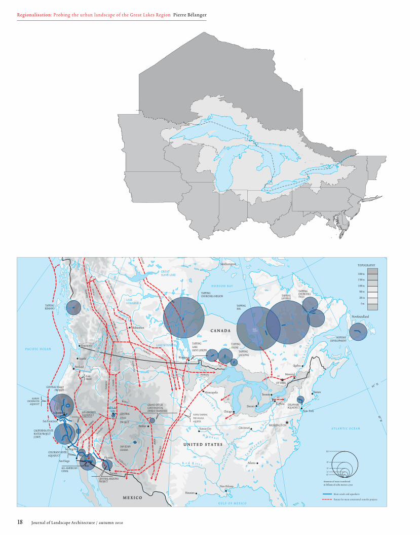
Figure 15 below Pipe Dreams: Great Lakes water diversions in the con-text of current and future inter-basin projects across North America, the source of looming cross-regional politics along the longest, least disputed border in the world. Source: 2005 Frédéric Lasserre and Philippe Rekacewicz, Major Water Transfers: Tools of Development or Instruments of Power (University of Québec, 2005).
Figure 16 Brave New Ecology: A 42-kilogramme bighead carp caught in the upper reaches of the Mississippi River. Intro-duced to fish farms in America during the 1830s and migrat-ing north to the Great Lakes, this vigorous species thrives in heavily polluted waters and can jump up to 3 metres out of the water. Source: Darin Opel and Illinois Bowfishers Club, 2008.
20 Journal of Landscape Architecture / autumn 2010
Lake Ontario(244m deep)
Niagara Falls
Welland CanalSt. Lawrence River
Lake Erie(64m deep)
Lake Huron(229m deep)Lake Michigan
Lake Superior(406m deep)
Soo Locks
TorontoHamilton
NiagaraBuffalo
Windsor
Sarnia
Goderich
Kingston
Oshawa
Sault Ste Marie
Escanaba
Green BayManitowoc
Milwaukee
Racine
Chicago
Duluth
Gary
Rochester
Erie
ClevelandSandusky
Toledo
Detroit
Saginaw
Alpena
Ludington
Benton Harbor
Superior
200.0
180.0
160.0
140.0
120.0
100.0
80.0
60.0
40.0
20.0
0.0 (Sea Level)
-20.0
- 40.0
-60.0
-80.0
-100.0
-120.0 m
km335.77473.3140.89
32.97
60.87
413.3671.9442.47
548.41 39.70
74.00m asl
173.00m asl176.00m asl176.00m asl183.00m asl
783.53
(282m deep)
St. Clair River
Lake St. Clair
Detroit River
St. Mary's River
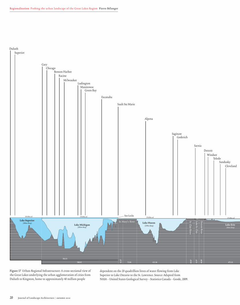
Figure 17 Urban-Regional Infrastructure: A cross-sectional view of the Great Lakes underlying the urban agglomeration of cities from Duluth to Kingston, home to approximately 40 million people
dependent on the 20 quadrillion litres of water flowing from Lake Superior to Lake Ontario to the St. Lawrence. Source: Adapted from NASA – United States Geological Survey – Statistics Canada – Geode, 2009.
Regionalisation : Probing the urban landscape of the Great Lakes Region Pierre Bélanger

21Journal of Landscape Architecture / autumn 2010
this shift. (Fig. 17) As measures of intelligence, the mapping of inter-re-gional flows and reciprocities provides a base to register and effect change over time. Instead of a single, bounded, closed, homogeneous environ-ment, the regionalisation of the Great Lakes can open a wider and richer horizon on a systemic network of endogenous and exogenous processes at work. When viewed telescopically at different resolutions and scales, the region can then be understood as a system of systems. [8]
In this expanded field, the regionalisation of design practice can tran-scend conventional spatial boundaries, disciplinary territories and po-litical ideologies. Design can be liberated from the straitjacket of short-sighted bureaucratic time scales and the confinement of jurisdictional site boundaries. Capitalising on geopolitical cleavages, design can unearth and propose mutual, cooperative, interdependent and synergistic strat-egies at large scales that spin off inter-regionally. Consequently, design can be informed by continental geography and global ecologies while be-ing elevated to the superintendence of time. The physiographic and polit-ical regionalisation of urban areas thus moves beyond that of mere back-ground for planning or mere unit of development. As planning tactic and design strategy, regionalisation becomes instrumental and infrastructur-al, setting the precedent for landscape reclamation and landscape urbani-sation across the continent and other industrialised regions of the world, from the Americas to Asia to Africa. (Fig. 18)
From the 40 million acres of Cutover land to the management of over 20 quadrillion litres of fresh water in the watershed, the engagement of the Great Lakes as a complex regional landscape is therefore pressing. If fresh water is the oil of the 21st century, than the agency of urban regions is of critical and contemporary significance, globally.
Lake Ontario(244m deep)
Niagara Falls
Welland CanalSt. Lawrence River
Lake Erie(64m deep)
Lake Huron(229m deep)Lake Michigan
Lake Superior(406m deep)
Soo Locks
TorontoHamilton
NiagaraBuffalo
Windsor
Sarnia
Goderich
Kingston
Oshawa
Sault Ste Marie
Escanaba
Green BayManitowoc
Milwaukee
Racine
Chicago
Duluth
Gary
Rochester
Erie
ClevelandSandusky
Toledo
Detroit
Saginaw
Alpena
Ludington
Benton Harbor
Superior
200.0
180.0
160.0
140.0
120.0
100.0
80.0
60.0
40.0
20.0
0.0 (Sea Level)
-20.0
- 40.0
-60.0
-80.0
-100.0
-120.0 m
km335.77473.3140.89
32.97
60.87
413.3671.9442.47
548.41 39.70
74.00m asl
173.00m asl176.00m asl176.00m asl183.00m asl
783.53
(282m deep)
St. Clair River
Lake St. Clair
Detroit River
St. Mary's River
Figure 18 Interregional Urbanism: Geospatial context of the Great Lakes and the distribution of urban patterns across North America. Source: NASA – United States Geological Survey, 2008.

Journal of Landscape Architecture / autumn 201022
AcknowledgementsFor graphic imaging, I would like to thank Aisling O'Carroll, Hoda Matar, Michelle Dobbie and David Christensen. For image permissions, Darin Opel and Christine Appleberg (Illinois Bowfishers Club), Sandra Rusch Walton (Milwaukee Public Library), Gary Petersen and Terri Grote (Mil-
Notes
This essay is a condensed version of a longer, annotated chap-
ter for a forthcoming book entitled Landscape Infrastructure
on the contemporary convergence of landscape and urban in-
frastructure in the fields of planning, design and engineering.
This essay is also informed by two earlier texts: Redefining In-
frastructure in Ecological Urbanism edited by Mostafavi and
Doherty (Baden, Switzerland: Lars Müller Publishers, 2010):
332-349, and Landscape as Infrastructure in Landscape Journal 28
(Spring 2009): 79-95.
1. The term super-urbanisation was originally used by
Benton Mackaye almost a century ago in The New Exploration. (Mackaye 1928).
2. On the significance of the economies of disassembly and
demanufacturing to urban restructuring, see Bélanger (2007),
deFever (2008) and Peck (2009).
3. Through independent investigative efforts, three events
stand out as milestones in the reclamation of the Great Lakes
as a system. The first stems from the development of the On-
tario Conservation Authorities Act. Following Hurricane Hazel
in 1954, one of the most severe storm events to hit the Great
Lakes in urban history, the Act sought to bridge administra-
tive, technocratic and disciplinary gaps between national, pro-
vincial and municipal infrastructure authorities and conserva-
tion agencies. Regional conservation authorities were granted
special powers for the re-zoning and re-planning of privately
owned land in floodplains as riparian infrastructure. The sec-
ond development involved a staff of five at the Milwaukee
Sentinel Journal who won the Pulitzer Prize for Public Service.
They championed a national effort for the conservation of nat-
ural resources through the control of industrial discharges,
namely by the treatment of waste fluids at source before en-
tering the watershed. The third development involves the dis-
covery of buried chemicals below the Love Canal by Lois Marie
Gibbs, leading to the birth of the United States Environmen-
tal Protection Agency (USEPA) in 1971. The toxic ecology of
the Love Canal became the first Superfund site in the U.S., one
of the most important legislative programmes in the U.S. Al-
most a decade later, combined efforts in the states of Wiscon-
sin and New York led to the Federal Clean Water Act in 1977
introduced by Jimmy Carter to eliminate all wastewater dis-
charges into the nation’s waters.
4. This systems-based strategy involves the more substantive,
complex and proactive engagement of the natural and built
systems, eventually leading to the formulation of more intelli-
gent design scenarios at larger scales. (Berger 2009)
5. The city, as an industrial concept, implies a spatial distinc-
tion between the civilised metropolis and the hostile hinter-
land. Canadian economist and public historian Harold A. Innis
established views on the indivisibility of geography and indus-
trialisation as lead triggers of New World regionalism: “North
America is deeply penetrated by three vast inlets from the At-
lantic – the Mississippi, the St. Lawrence, and the Hudson Bay,
and the rivers of its drainage basin. In the northern part of
the continent or in Canada extensive waterway and the domi-
nant Pre-Cambrian formation have facilitated concentration
on bulk products the character of which has been determined
by the culture of aborigines and by the effectiveness of navi-
gation by lake, river, and ocean to Europe.” (Innis 1950: 23) As
one of the most overlooked public intellectuals of 20th-centu-
ry North America, Innis demystified complex subjects such as
politics and imperialism, culture and communications. Innis’s
regional views on society and media are best known for their
influence on media intellectual Marshall McLuhan.
6. The failure of colonial-style eradication to subdue more
than 100 species of exotic plants, fish and algae in the Great
Lakes testifies to the persistence and sustainability of global
trans-regional ecological flows. (Del Tredici 2006; Schaper 2006; Smith 1996)
7. Regionalism should not and cannot be based solely on envi-
ronmental determinism or on conventional conservatism. The
comparison of three historical views on resource conservation
is informative. On one level, there is a view sponsored by Gar-
rett Hardin in The Tragedy of the Commons that calls for the
public coordination and management of resources as a com-
monwealth (Hardin 1968). On another more controversial lev-
el, conservation and management of resources was called into
question by Henry Ford who claimed that “conserving our
natural resources by withdrawing them from use is not a serv-
ice to the community. That is holding to the old theory that
a thing is more important than a man. Our natural resources
are ample for all our present needs. We do not have to bother
about them as resources. What we have to bother about is the
waste of human labour” (Ford and Crowther 1926: 90) On another
more extreme level, Ayn Rand argued: “Contrary to the ‘argu-
ment from scarcity’, if you want to make a ‘limited’ resource
available to the whole people, make it private property and
throw it on a free, open market.” (Rand 1967: 134)
8. Ecologist Howard T. Odum and his father Howard W.
Odum were pioneers of 20th-century regionalism in America:
“The significance of regionalism as the key to equilibrium is re-
flected in an extraordinary range of situations, such as the con-
flict between nationalism and internationalism, between sec-
tionalism and federalism, and the imbalance between agrarian
and urban life, between agriculture and industry, between in-
dividuation and socialisation in governmental trends, between
a quantity of civilisation of standardising forces and a quality
world, between machines and men”. (Odum and Moore 1938: 5)
References
Adelaja, S. and McKeown, C. 2008. Michigan’s Offshore Wind Potential. Lansing, MI: MSU Land Policy Institute.
American Public Works Association (APWA). 2000.
Top Ten Public Works Projects of the Century 1900-2000.
www.apwa.net/About/Awards/TopTenCentury.
[accessed 21 June 2009]
Annin, P. 2006. The Great Lakes Water Wars.
Washington, D.C.: Island Press.
Austin, J. and Affolter-Caine, B. 2006. The Vital Center: A Federal-State Compact to Renew the Great Lakes Region. Washington, DC:
The Brookings Institution Metropolitan Policy Program.
Bélanger, P. 2009. Landscape as infrastructure.
Landscape Journal 28 (1): 79-95.
Bélanger, P. 2007. Landscapes of disassembly.
Topos 60 (October): 83-91.
Bello, W. 2005. Deglobalization: Ideas for a New World Economy.
London: Zed Books.
Berger, A. 2009. Systemic Design Can Change the World.
Amsterdam:SUN Publishers.
Changnon, S. A. and Harper, M. E. 1994. History of the Chicago
Diversion and Future Implications. In The Lake Michigan Diver-sion at Chicago and Urban Drought, Stanley A. Changnon,
ed. Mahomet, IL: NOAA Contract 50WCNR306047.
Chicago Department of Health. 1919. General and Chronological Summary of Vital Statistics, Annual Report 1911-1918. Reprint Se-
ries No.16. Chicago, IL: The Department of Health: 1424.
Choate, P. and Walter, S. 1983. America in Ruins: The Decaying Infrastructure. Durham, NC: Duke University Press.
Collins, D.R. 1990. Pioneer Plowmaker: A Story about John Deere.
Minneapolis, MN; Carolrhoda Books.
Cucci, G. 1979. The City in Agrarian Ideology and Frank Lloyd
Wright. In: The American City: From the Civil War and the New Deal, Giorgio Cucci, Francesco Dal Co, Mario Manieri-Elia
and Manfredo Tafuri, eds. Cambridge, MA: MIT Press.
Dandaneau, S.P. 1996. A Town Abandoned: Flint, Michigan, Confronts Deindustrialization. Albany, NY: State University
of New York Press.
deFever, D. 2008. Increasing demand for metal means big
profits for Genesee County residents who collect, sell scrap.
The Flint Journal, June 6.
Del Tredici, P. 2006. Brave new ecology.
Landscape Architecture Magazine 96: 46-52.
Doxiadis, C.A. 1967-1970. Emergence and Growth of an Urban Region: The Developing Urban Detroit Area, Vols. 1-3. Detroit,
MI: Detroit Edison Company.
Ducks Unlimited Canada. 2009. Natural Capital and Ecological
Goods and Services. In: Ducks Unlimited Canada Natural
waukee Department of City Development), Frédéric Laserre (Université Laval), Patrick Martin and Don Durfee (Society of Industrial Archaeology), Don Coles (Great Lakes Aerial Photography) and Whitney French (Farns-worth House, Landmarks Illinois).
Regionalisation : Probing the urban landscape of the Great Lakes Region Pierre Bélanger

Journal of Landscape Architecture / autumn 2010 23
Values: Linking The Environment To The Economy.
www.ducks.ca/conserve/wetland_values/conserve.html.
[accessed 14 February 2009]
Ely, R.T. and Wehrwein, G. 1940. Land Economics.
New York: The MacMillan Company.
Environment Canada. 1999. The State of Municipal Wastewater Effluents in Canada. Ottawa, ON: Queen’s Printer.
Florida, R., Gulden, T. and Mellander, C. 2007. The Rise of the Mega Region. Toronto, ON: The Martin Prosperity Institute.
Ford, H. and Crowther, S. 1926. Today and Tomorrow.
London: William Heinemann, Ltd.
Ford, H. and Crowther, S. 1922. My Life and Work. Garden City,
NY: Doubleday, Page & Company.
Forman, R.T.T. 1995. Ecology of Regions. In Land Mosaics: The Ecology of Landscapes and Regions. Cambridge, UK: Cambridge
University Press: 22-28.
Friedman, T.L. 2005. The World Is Flat: A Brief History of the Twenty-first Century. New York: Farrar, Straus & Giroux.
Garreau, J. 1981. The Nine Nations of North America.
Boston: Houghton Mifflin Company.
Geddes, P. 1915. Cities in Evolution: An Introduction to the Town Planning Movement and to the Study of Civics.
London: Williams & Norgate.
Glaeser, E.L. 2007. Can Buffalo Ever Come Back?
City Journal 17(4): 94-99.
Goodman, P.S. 2008. A Splash of Green for the Rust Belt.
New York Times, 1 November.
Gottmann, J. 1990. Megapolitan systems around the world.
In Since Megalopolis: The Urban Writings of Jean Gottmann,
J. Gottmann and R.A. Harper, eds. Baltimore: The Johns
Hopkins University Press: 162-171.
Gottmann, J. 1957. Megalopolis: The Urbanized Northeastern Sea-board of the United States. New York: Twentieth Century Fund.
Great Lakes Information Network. 2009. Demographics in the
Great Lakes Region. www.great-lakes.net/econ/refs/demog.
html. [accessed 7 March 2009]
Great Lakes Water Institute (GLWI). 2009. Great Lakes Water
Balance. www.glwi.uwm.edu/ourwaters/documents/Great-
LakesWaterBalanceBWeb.pdf [accessed 26 March 2009]
Great Lakes Water Institute (GLWI). 2008.
Our Waters: Diversions of Great Lakes Water. Fact Sheet 03.
Hall, C.G.L. 1997. Steel Phoenix: The Fall and Rise of the U.S. Steel Industry. New York: Palgrave MacMillan.
Hardin, G. 1968. Tragedy of the commons. Science 162:1243-1248.
Harvey, D. 1996. Globalization and deindustrialization: A city
abandoned. International Journal of Politics, Culture and Society
10(1): 175-191.
Hoornbeek, J.A. 2005. The promises and pitfalls of devolution:
Water pollution policies in the American states.
Publius: The Journal of Federalism 35(1): 87-114.
Hough, M. 1983. The urban landscape - The next frontier.
Bulletin of the Association for Preservation Technology 15(4): 9-14.
Innis. H. 1950. Empire and Communications.
Cambridge: U.K.: Oxford University Press.
International Joint Commission (IJC) Canada & United States.
2008. Treaties & Agreements. www.ijc.org/rel/agree/water.html.
[accessed 5 November 2008]
Jacobs, J. 1970. The Economy of Cities. New York: Vintage Books.
Jones, R. 2004. As Detroit falters, Asian makers pick up speed:
Toyota likely to surpass GM as world’s top carmaker;
China lurks in wings. www.msnbc.msn.com/id/10532121/.
[accessed 24 July, 2008]
Kates, J. 2001. Planning a Wilderness: Regenerating the Great Lakes Cutover Region. Minneapolis: University of Minnesota Press.
Krugman, P. 1997. We are not the World. New York Times,
13 February.
Lanks, B. 2006. The incredible shrinking city – Facing steep
population decline, Youngstown, Ohio, is repositioning itself.
Metropolis Magazine, May.
Laserre, F. and Rekacewicz, P. 2005. “Des projets pharaoniques
autant que destructeurs”. Le Monde diplomatique (March 2005):
18 -19.
LeDuff, C. 2009. To Urban Hunter, Next Meal is Scampering By.
www.detnews.com/article/20090402/METRO08/904020395.
[accessed 30 July 2008]
Leman Group, ed. 1976. Great Lakes Megalopolis: From Civili- zation to Ecumenization. Ottawa, ON: Canada Ministry of
State - Urban Affairs.
Lovejoy, P.S. 1920. Michigan's Millions of Idle Acres.
Detroit News, 24 May-4 June: 3-11.
Mackaye, B. 1928. The New Exploration.
New York: Harcourt, Brace and Company.
McGrath, K.A. 1999. World of Invention: History's Most Significant Inventions and the People Behind Them.
Farmington Hills, MI: Gale Research Group
Meyer, D.R. 1983. Emergence of the American
manufacturing belt: An interpretation.
Journal of Historical Geography 9(2): 145-174.
Mohl, R. 1997. The Making of Urban America.
Lanham, MD: Rowman & Littlefield Publishing.
Mumford, L. 1938. The Culture of the Cities.
New York: Harcourt, Brace and Company.
Nassauer, J. and VanWieren, R. 2008. Vacant Property Now & Tomorrow: Building Enduring Values with Natural Assets.
Ann Arbor, MI: Sea Grant, Michigan, Genesee Institute,
Genesee County Land Bank, School of Natural Resources
and the Environment, University of Michigan.
New York Times. 1897. Chicago’s Canal and the Lakes,
3 January: 12.
Odum, H. T. 1983. Ecological and General Systems: An Introduction to Systems Ecology. Rev. ed. New York: John Wiley & Sons.
Odum, H.W. and Moore, H.E. 1938. American Regionalism.
New York: Henry Holt and Company.
Peck, D. 2009. Disassembly line: The unbuilding of an auto
plant. The Atlantic, March-April.
Quinn, F. 1988. Interbasin Water diversions: A Canadian per-
spective. Journal of Soil and Water Conservation 42(6): 389-393.
Rabinowitz, A. 2004. Urban Economics and Land Use in America: The Transformation of Cities in the Twentieth Century.
New York: M.E. Sharpe.
Rand, A. 1967. Capitalism: The Unknown Ideal. New York: Signet.
Robinson, S.K. 2005. Does Frank Lloyd Wright Belong in Chica-
go's Architectural History? In Chicago Architecture: Histories, Re-visions, Alternatives, C. Waldheim, C. and R. K. Rüedi, eds. Chica-
go: University of Chicago Press: 53-60.
Sandin, J. 2001. 30 years later, cleanup still fighting current.
Milwaukee Journal Sentinel, 9 September.
Sassen, S. 2007. Megaregions: Benefits beyond Sharing Trains
and Parking Lots? InThe Economic Geography of Megaregions,
K.S. Goldfield. Princeton, NJ: Policy Research Institute for
the Region.
Sassen, S. 1998. Globalization and Its Discontents: Essays on The New Mobility of People and Money. New York: The New Press.
Schaper, D. 2006. Asian Carp: Can't Beat Them? Eat Them.
National Public Radio – All Things Considered, 12 July.
Schmidt, S. and Buehler, R. 2007. The planning process in the
U.S. and Germany: A comparative analysis. International Plan-ning Studies 12(1): 55-75.
Schneider, D.C. 2001. The rise of the concept of scale in ecology.
BioScience 51(7): 545-553.
Smith, D. 1996. European tastes could help solve decades -
old Great Lakes problem; Sea lamprey might become dinner.
Star Tribune, 11 May.
Sutter, P. 1999. A retreat from profit: Colonization, the Appa-
lachian Trail, and the social roots of Benton MacKaye's
wilderness advocacy. Environmental History 4(4): 553-577.
Taylor, B. 2002. On the rise: signs of a healthier manufacturing
sector are being seen in increased demand and pricing for fer-
rous scrap. www.recyclingtoday.com/articles/article.asp?MagI
D=1&ID=4369&IssueID=144. [accessed 15 February 2009]
Time. 1952. Taconite Boom, 28 April.
Waldheim, C. and Berger, A. 2009. Logistics landscape.
Landscape Journal 27(2): 219-246.
World Business Chicago. 2009. Great Lakes & St. Lawrence Re-
gion. www.glslcities.org/documents/GreatLakesandStLawren-
ceEconomy2008extended.pdf. [accessed 19 December 2009]
Wright, F.L. 1958. The Living City. New York: Horizon Press: 162.
Wright, F.L. 1941. Chicago 1918. In Frank Lloyd Wright On Archi-tecture: Selected Writings 1894-1940, Frederick Gutheim, ed.
New York: Duell, Sloan and Pearce: 85-97.
Biographical Notes
Pierre Bélanger is a landscape architect, urban planner and
Associate Professor at the Harvard University Graduate School
of Design, teaching graduate courses on landscape, infrastruc-
ture and urbanism in the interrelated fields of planning,
design and engineering. He is editor of the Landscape Infrastruc-tures DVD published by the National Research Council Canada
and recipient of the Professional Prix de Rome in Architecture
awarded by the Canada Council for the Arts.
Contact
Pierre Bélanger
www.gsd.harvard.edu/people/faculty/belanger/index.html