Embed Size (px)
Citation preview

Thank you for purchasing a NISSAN automobile.This user’s manual is for the navigation systemonly.
Please read this manual carefully to ensure safeoperation of the navigation system. This manualcontains operating instructions for the NISSANNavigation System offered in your NISSAN ve-hicle
● Please read your vehicle’s owner’s manualfirst.
● Do not remove this manual from the vehiclewhen selling this vehicle. The next user of thisnavigation system may need the manual.
● Because of possible specification changes,sections of this manual may not apply to yourvehicle.
● All information, specifications and illustrationsin this manual are those in effect at the time ofprinting. NISSAN reserves the right to changespecifications or design at any time withoutnotice.
FOREWORD
Z REVIEW COPY—2004 Maxima (max)Navigation System OM (navi)—USA_English (nna)04/27/04—tbrooks X

Z REVIEW COPY—2004 Maxima (max)Navigation System OM (navi)—USA_English (nna)04/27/04—tbrooks X
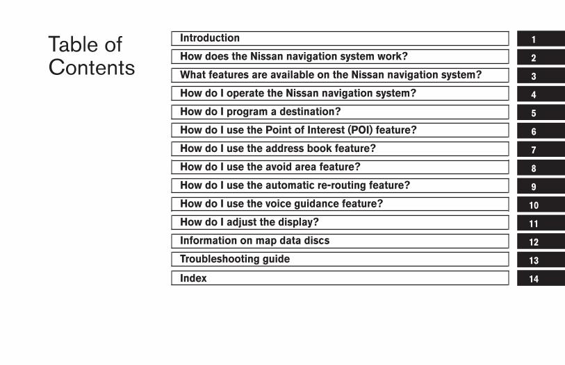
Table ofContents
Introduction
How does the Nissan navigation system work?
What features are available on the Nissan navigation system?
How do I operate the Nissan navigation system?
How do I program a destination?
How do I use the Point of Interest (POI) feature?
How do I use the address book feature?
How do I use the avoid area feature?
How do I use the automatic re-routing feature?
How do I use the voice guidance feature?
How do I adjust the display?
Information on map data discs
Troubleshooting guide
Index
1
2
3
4
5
6
7
8
9
10
11
12
13
14

Z REVIEW COPY—2004 Maxima (max)Navigation System OM (navi)—USA_English (nna)04/27/04—tbrooks X
1 Introduction
How to use this manual . . . . . . . . . . . . . . . . . . . . . . . . . . . . 1-2For safe operation . . . . . . . . . . . . . . . . . . . . . . . . . . . . . . 1-2Reference symbols . . . . . . . . . . . . . . . . . . . . . . . . . . . . . 1-2
Safety note . . . . . . . . . . . . . . . . . . . . . . . . . . . . . . . . . . . . . . . 1-2Laser product . . . . . . . . . . . . . . . . . . . . . . . . . . . . . . . . . . 1-3
Z REVIEW COPY—2004 Maxima (max)Navigation System OM (navi)—USA_English (nna)04/27/04—tbrooks X
This manual uses special words and icons, orga-nized by function. Please refer to the followingitems and familiarize yourself with these symbols.
FOR SAFE OPERATION
WARNING
This is used to indicate the presence ofa hazard that could cause death or se-rious personal injury. To avoid or re-duce the risk, the procedures must befollowed precisely.
CAUTION
This is used to indicate the presence ofa hazard that could cause minor ormoderate personal injury or damage toyour vehicle. To avoid or reduce therisk, the procedures must be followedcarefully.
NOTE:
This indicates an item to help you under-stand the maximum performance of yourvehicle. If ignored, it may lead to a mal-function or poor performance.
REFERENCE SYMBOLS
INFO:
This indicates information necessary for efficientuse of your vehicle or accessories.
DEST button
This is a button on the control panel.
View key
This is a select key on the screen. By selectingthis key you can proceed to the next function.
This system is primarily designed to help youreach your destination, and also performs otherfunctions as outlined in this manual. However,you, the driver, must use the system safely andproperly. Information concerning roadconditions, traffic signs and the availability ofservices may not always be up-to-date. Thesystem is not a substitute for safe, proper,and legal driving.
Before using the navigation system, please readthe following safety information. Always use thesystem as outlined in this manual.
WARNING
● When the driver operates the naviga-tion system or uses the joystick(screen function), first park the ve-hicle in a safe place and set the park-ing brake. Using the system whiledriving can distract the driver andmay result in a serious accident.Destinations cannot be set while thevehicle is in motion.
● Do not rely on voice guidance alone.Always be sure that all driving ma-neuvers may be made legally andsafely to avoid an accident.
HOW TO USE THIS MANUAL SAFETY NOTE
1-2 Introduction
Z REVIEW COPY—2004 Maxima (max)Navigation System OM (navi)—USA_English (nna)04/27/04—tbrooks X
● Do not disassemble or modify thissystem. If you do, it may result inaccidents, fire, or electrical shock.
● Do not use this system if you noticeany malfunction such as a frozenscreen or lack of sound. Continueduse of the system may result inaccident, fire, or electrical shock.
● If you notice any foreign object in thesystem hardware or spilled liquid, ornotice smoke or a smell coming fromit, stop using the system immediatelyand contact your nearest NISSANdealer. Ignoring such conditions maylead to accidents, fire, or electricalshock.
NOTE:
Some states/provinces may have laws lim-iting the use of video screens whiledriving. Use this system only where legal.
LASER PRODUCTThis navigation system is certified as a Class Ilaser product.
The navigation system complies with DHHSLaser-Radiation Standards, 21 CFR Chapter 1,subchapter J.
WARNING
● Do not disassemble or modify thissystem. There are no user service-able parts in this navigation system.
● If maintenance, adjustments and op-erations other than those specifiedin this manual are attempted, injurydue to laser radiation and exposurecould occur.
Introduction 1-3
Z REVIEW COPY—2004 Maxima (max)Navigation System OM (navi)—USA_English (nna)04/27/04—tbrooks X

1-4 Introduction
MEMO
2 How does the Nissan navigation systemwork?
What is a navigation system? . . . . . . . . . . . . . . . . . . . . . . . 2-2About the navigation system . . . . . . . . . . . . . . . . . . . . . 2-2
What is GPS (Global Positioning System)?. . . . . . . . . . . 2-2Accuracy of positioning . . . . . . . . . . . . . . . . . . . . . . . . . 2-2Positioning adjustment . . . . . . . . . . . . . . . . . . . . . . . . . . 2-3
Receiving signals from GPS satellites. . . . . . . . . . . . . 2-3Display of GPS information . . . . . . . . . . . . . . . . . . . . . . 2-3
Detailed map coverage areas (MCA) for thenavigation system . . . . . . . . . . . . . . . . . . . . . . . . . . . . . . . . . 2-3
When a gray road is displayed on the map . . . . . . . . 2-4
Z REVIEW COPY—2004 Maxima (max)Navigation System OM (navi)—USA_English (nna)04/27/04—tbrooks X
ABOUT THE NAVIGATION SYSTEMThis navigation system combines the data ob-tained from the vehicle (by gyro sensor) and fromGPS (Global Positioning System) satellites tocalculate the current location of the vehicle. Thisposition is then displayed on the screen, allow-ing route guidance to a destination.
GPS is a system developed and operated by theU.S. Government, covering the entire planet.This navigation system receives three or moredifferent radio signals from NAVSTAR (GPSsatellites), orbiting the earth 13,049 miles(21,000 km) above ground. The data from differ-ent sets of signals are trigonometrically calcu-lated to obtain the position of the vehicle.
INFO:
The tracking center in the U.S. controls signalstransmitted from GPS satellites. This controlsometimes results in reduced accuracy or nosignal received at all, in accordance with govern-ment requirements. Consequently, areas such asmilitary bases may not accurately appear on thenavigation screen. ACCURACY OF POSITIONING
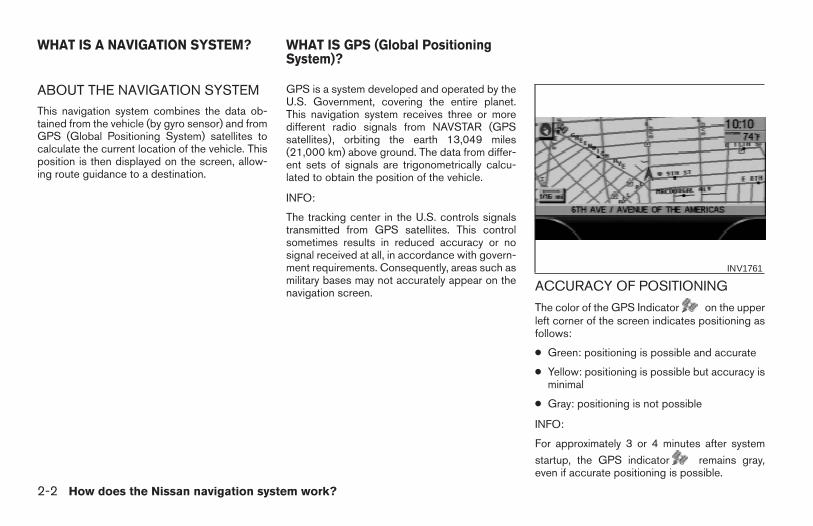
The color of the GPS Indicator on the upperleft corner of the screen indicates positioning asfollows:
● Green: positioning is possible and accurate
● Yellow: positioning is possible but accuracy isminimal
● Gray: positioning is not possible
INFO:
For approximately 3 or 4 minutes after system
startup, the GPS indicator remains gray,even if accurate positioning is possible.
INV1761
WHAT IS A NAVIGATION SYSTEM? WHAT IS GPS (Global PositioningSystem)?
2-2 How does the Nissan navigation system work?
Z REVIEW COPY—2004 Maxima (max)Navigation System OM (navi)—USA_English (nna)04/27/04—tbrooks X
POSITIONING ADJUSTMENT
When the system judges that the vehicle posi-tion information is not accurate based on vehiclespeed and gyro sensor data calculations, thesystem will adjust the vehicle position informa-tion using GPS signals.
RECEIVING SIGNALS FROM GPSSATELLITES
Sometimes, satellite reception is weak. The fol-lowing are places where signals tend to beweak:
● Inside tunnels and parking lots in buildings
● Areas with numerous tall buildings
● Under multi-layered highways
● In a dense forest
● Near military bases and certain governmentfacilities
Vehicles in these areas may not receive GPSsignals (Indicator color: gray).
INFO:
The antenna for GPS is located on the instru-ment panel inside the vehicle. Do not placeany objects, especially mobile phones ortransceivers, on the instrument panel. Be-
cause the strength of the GPS signals are ap-proximately one billionth of that of TV waves;phones and transceivers will decrease thestrength or may totally disrupt the signals.
DISPLAY OF GPS INFORMATIONThis system displays GPS information.
Please refer to “GPS information display” onpage 11-17.
NOTE:
Directional guidance provided by the navi-gation system does not take carpool lanedriving into consideration, especially whencarpool lanes are separated from otherroad lanes.
This system is designed to help you reach yourdestination, and also performs other functions asoutlined in this manual. However, you, the driver,must use the system safely and properly. Infor-mation concerning road conditions, traffic signsand the availability of services may not always beup-to-date. The system is not a substitute forsafe, proper, and legal driving.
Map data covers select metropolitan areas in theUnited States.
Map data is available on map DVD-ROM. For in-formation about map DVD-ROMs, contact aNISSAN dealer or call the NISSAN NavigationSystem help desk at 1-800-NISSAN-1(1-800-647-7261).
Map data includes 2 types of areas: “Detailedcoverage areas” providing all detailed road dataand other areas showing “Main roads only”.
NOTE:
Detailed map data is not available in manyareas and is generally limited to select ma-jor metropolitan areas.
For information on which metropolitan areas arein detailed coverage areas, please refer to theNISSAN Navigation System Software Booklet
DETAILED MAP COVERAGE AREAS(MCA) FOR THE NAVIGATION SYS-TEM
How does the Nissan navigation system work? 2-3
Z REVIEW COPY—2004 Maxima (max)Navigation System OM (navi)—USA_English (nna)04/27/04—tbrooks X
(included). When you purchase an updated mapDVD-ROM, a new software booklet will beprovided.
WHEN A GRAY ROAD IS DIS-PLAYED ON THE MAP● Route calculation may not be possible when a
destination or the current vehicle location isnear a gray road.
● When setting a destination, the road near thecross cursor blinks. For gray roads, however,the road may not blink.
● When you are driving on a gray road after thevehicle has deviated from the suggestedroute during route guidance, automatic re-routing may not start immediately.
● Route guidance (enlarged view and voiceguidance) may not be done at the intersectionwhere the road your vehicle is driving on and agray road intersect.
● POI information and street names near grayroads are not contained in the map data.
2-4 How does the Nissan navigation system work?
Z REVIEW COPY—2004 Maxima (max)Navigation System OM (navi)—USA_English (nna)04/27/04—tbrooks X
3 What features are available on theNissan navigation system?
Route guidance . . . . . . . . . . . . . . . . . . . . . . . . . . . . . . . . . . . 3-2Point of interest (POI) directory . . . . . . . . . . . . . . . . . . . . . 3-2Address book . . . . . . . . . . . . . . . . . . . . . . . . . . . . . . . . . . . . . 3-2Avoid area . . . . . . . . . . . . . . . . . . . . . . . . . . . . . . . . . . . . . . . . 3-3Automatic re-route. . . . . . . . . . . . . . . . . . . . . . . . . . . . . . . . . 3-3
Detour . . . . . . . . . . . . . . . . . . . . . . . . . . . . . . . . . . . . . . . . . . . 3-3Birdview™ . . . . . . . . . . . . . . . . . . . . . . . . . . . . . . . . . . . . . . . . 3-4Voice guidance. . . . . . . . . . . . . . . . . . . . . . . . . . . . . . . . . . . . 3-4Short menus . . . . . . . . . . . . . . . . . . . . . . . . . . . . . . . . . . . . . . 3-4
Z REVIEW COPY—2004 Maxima (max)Navigation System OM (navi)—USA_English (nna)04/27/04—tbrooks X
The main feature of the NISSAN Navigation Sys-tem is Visual and Audio Route Guidance in se-lected detailed map coverage areas. Utilizing anetwork of GPS (Global Positioning System)satellites, the NISSAN Navigation System tracksyour location on the map and directs you whereyou want to go.
Once you program a destination covered by adetailed map, The NISSAN Navigation Systemwill determine a route from your current locationto your destination. The moving map display andturn-by-turn voice commands help the driver de-termine upcoming turns.
This feature can be especially helpful in findingunfamiliar locations or businesses. The systemmay be unable to set a destination and/or calcu-late distance when a destination is outside a de-tailed map coverage area. Additionally, audioroute guidance may not be available if the desti-nation is outside a detailed map coverage area.For more information on how to program adestination, please refer to section 5.
The NISSAN Navigation System offers an exten-sive Point of Interest (POI) directory in detailedmap coverage areas for your convenience. Thisdirectory includes a wide variety of destinationsranging from gas stations, ATMs, and restau-rants to casinos, ski resorts, shopping centersand businesses. By accessing the Point of Inter-est directory, you can search for addresses andphone numbers for a destination, and with apress of a button, the NISSAN Navigation Sys-tem will calculate a route to the destination.
The Point of Interest directory offers many uses.For example, the directory can be sorted by thevarious types of restaurants near your currentlocation. If you need an ATM or gas station, theNISSAN Navigation System can point you to theclosest one or the closest one of your favoritebrand.
For more information on how to use the Point ofInterest directory, please refer to section 6.
Using the Address Book feature, you will havethe ability to store up to 50 locations in detailedmap coverage areas into a personal directory.This is especially useful for frequently visitedlocations, such as your clients, relatives, orfriends. The Address Book feature will provideyou with easy access to frequently visited loca-tions when setting them as your destination.
For more information on how to use your Ad-dress Book, please refer to section 7.
ROUTE GUIDANCE POINT OF INTEREST (POI) DIREC-TORY
ADDRESS BOOK
3-2 What features are available on the Nissan navigation system?
Z REVIEW COPY—2004 Maxima (max)Navigation System OM (navi)—USA_English (nna)04/27/04—tbrooks X
By using the Avoid Area feature, you can identifyareas or freeways that you would like theNISSAN Navigation System to avoid when plot-ting routes. For example, if you know of a freewayor area that is always congested with traffic, youcan program the NISSAN Navigation System toplot routes that go around that particular freewayor area.
For more information on the Avoid Area feature,please refer to section 8.
If you miss a turn while using the Route Guid-ance feature, the NISSAN Navigation Systemwill automatically recalculate a new route to yourdestination.
For more information on the Automatic Re-routefeature, please refer to section 9.
If you hear about a traffic accident on the radiothat is 4 miles (6 km) ahead of you and traffic isbacking up fast, you can use the Detour functionto calculate an alternative route that will help youavoid the gridlock caused by the traffic accident.The NISSAN Navigation System has the abilityto find an alternative route using secondaryroads that will return you to primary roads after aspecified number of miles.
For more information on the Detour feature,please refer to section 9.
AVOID AREA AUTOMATIC RE-ROUTE DETOUR
What features are available on the Nissan navigation system? 3-3
Z REVIEW COPY—2004 Maxima (max)Navigation System OM (navi)—USA_English (nna)04/27/04—tbrooks X
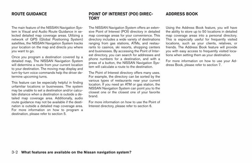
The NISSAN Navigation System gives you achoice of two map viewing styles, a normal2-dimensional Plan View map and the3-dimensional Birdview™ map. The 3-DBirdview™ map depicts a geographic area asseen from an elevated perspective, so you willget a better feel for the route ahead.
For more information on the Birdview™ feature,please refer to section 11.
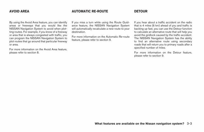
Route guidance is executed using voice andscreen instruction. When the vehicle ap-proaches an intersection where you need to turn,the voice guidance tells you the direction to take.
The system also has the following useful fea-tures:
● Enlarged display of intersections.
● Automatic rerouting when a vehicle is off thecourse (when map is displayed).
For more information on the Voice Guidancefeature, please refer to section 10.
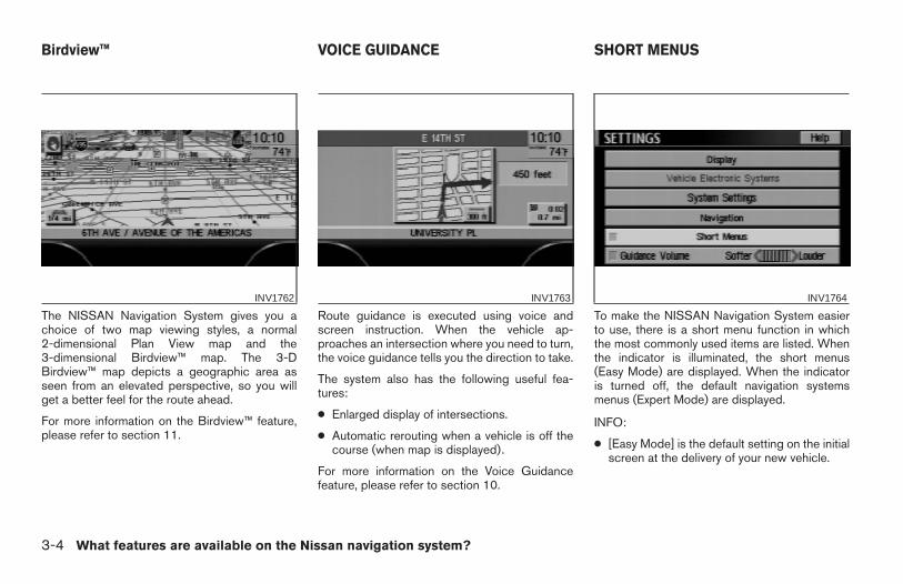
To make the NISSAN Navigation System easierto use, there is a short menu function in whichthe most commonly used items are listed. Whenthe indicator is illuminated, the short menus(Easy Mode) are displayed. When the indicatoris turned off, the default navigation systemsmenus (Expert Mode) are displayed.
INFO:
● [Easy Mode] is the default setting on the initialscreen at the delivery of your new vehicle.
INV1762 INV1763 INV1764
Birdview™ VOICE GUIDANCE SHORT MENUS
3-4 What features are available on the Nissan navigation system?
Z REVIEW COPY—2004 Maxima (max)Navigation System OM (navi)—USA_English (nna)04/27/04—tbrooks X
● Term [Expert Mode] is used in this manual
when the Short Menus key indicator isturned off. When the amber indicator is high-lighted, the system is set to [Easy Mode].
● When the SETTING , DEST orROUTE button is pressed in the [Easy
Mode] screen, the Help key is displayed.
For more information on the Short Menu feature,please refer to section 4.
What features are available on the Nissan navigation system? 3-5
Z REVIEW COPY—2004 Maxima (max)Navigation System OM (navi)—USA_English (nna)04/27/04—tbrooks X
3-6 What features are available on the Nissan navigation system?
MEMO
4 How do I operate the Nissan navigationsystem?
Control panel button functions . . . . . . . . . . . . . . . . . . . . . . 4-2Names of the components. . . . . . . . . . . . . . . . . . . . . . . 4-3
How to use the joystick and the enter button. . . . . . . 4-3How to use the PREV button . . . . . . . . . . . . . . . . . . 4-4How to use the SETTING button. . . . . . . . . . . . . . . 4-4How to use the DEST button . . . . . . . . . . . . . . . . . . 4-7How to use the ROUTE button . . . . . . . . . . . . . . . . 4-8
How to eject/insert the disc. . . . . . . . . . . . . . . . . . . . . . . . 4-10
Setting up the start-up screen . . . . . . . . . . . . . . . . . . . . . 4-13Confirmation of destination or waypoint . . . . . . . . . . 4-13
Clearing the memory . . . . . . . . . . . . . . . . . . . . . . . . . . . . . .4-16Setting the average speed. . . . . . . . . . . . . . . . . . . . . . . . . 4-18About route guidance . . . . . . . . . . . . . . . . . . . . . . . . . . . . .4-19
Notes on route guidance . . . . . . . . . . . . . . . . . . . . . . . 4-19About the display error . . . . . . . . . . . . . . . . . . . . . . . . . 4-21
Z REVIEW COPY—2004 Maxima (max)Navigation System OM (navi)—USA_English (nna)04/27/04—tbrooks X
LHA0254
CONTROL PANEL BUTTON FUNC-TIONS
4-2 How do I operate the Nissan navigation system?
Z REVIEW COPY—2004 Maxima (max)Navigation System OM (navi)—USA_English (nna)04/27/04—tbrooks X
NAMES OF THE COMPONENTS1. ( DAY/NIGHT ) button; refer to ve-
hicle’s Owner’s Manual. Changes displaybrightness.
2. PREV button; refer to page 4-4. Returnsto the previous screen during setup. Fin-ishes the setup after it is completed.
3. JOYSTICK and ENTER button; refer to thenext section. Scrolls the map, selects andsets each setting item.
4. SETTING button; refer to page 4-4. Per-forms various adjustments and settings tohelp you use the navigation system moreeffectively.
5. TRIP button; refer to vehicle’s Owner’sManual. Displays warning messages (ifthere are any) and displays TRIP 1 → TRIP2 → FUEL ECONOMY → MAINTENANCEeach time you press the button.
6. DEST button; refer to page 4-7. Displaysthe “Set a Destination” menu.
7. ROUTE button; refer to page 4-8. Dis-plays the setting menu screen at the time ofroute calculation.
8. MAP button; refer to page 5-36. Togglesbetween the intersection and the map dur-ing route guidance. Returns to the mapscreen from the settings screen.
9. GUIDE VOICE button; refer to page10-3. Provides voice guidance from thecurrent location.
10. ( ZOOM OUT ) button; refer topage 11-6. Alters the scale of the mapdisplay.
11. ( ZOOM IN ) button; refer to page11-6. Alters the scale of the map display.
12. ( EJECT ) button; refer to page4-10. Ejects the DVD.
HOW TO USE THE JOYSTICK ANDTHE ENTER BUTTON
The navigation system is operated by selectingkeys on the screen with the joystick and pressingthe joystick in to ENTER your selection. Be sureto understand the operation of the joystick be-fore using the navigation system.
Selecting the keys on the screen
Use the joystick to select keys on the screen.
The joystick can be tilted in eight directions. Theselected key will be highlighted in yellow.
INFO:
Use the joystick to scroll the map.
LNV0003
How do I operate the Nissan navigation system? 4-3
Z REVIEW COPY—2004 Maxima (max)Navigation System OM (navi)—USA_English (nna)04/27/04—tbrooks X
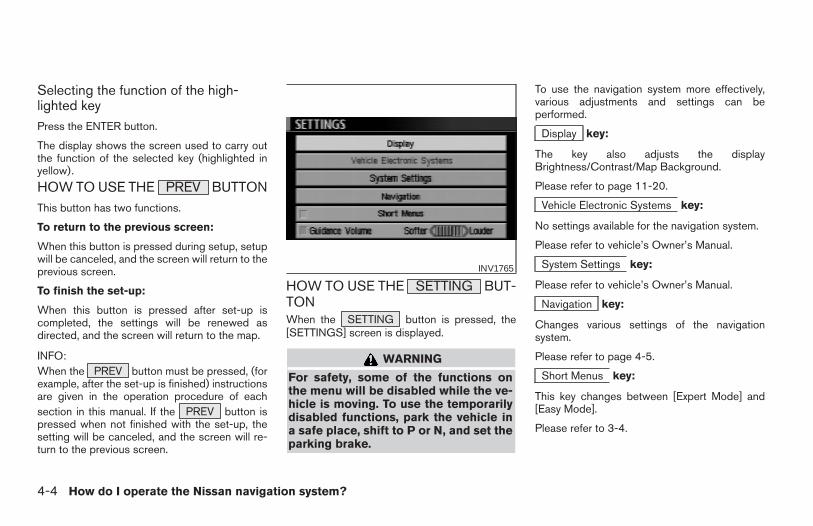
Selecting the function of the high-lighted keyPress the ENTER button.
The display shows the screen used to carry outthe function of the selected key (highlighted inyellow).
HOW TO USE THE PREV BUTTONThis button has two functions.
To return to the previous screen:
When this button is pressed during setup, setupwill be canceled, and the screen will return to theprevious screen.
To finish the set-up:
When this button is pressed after set-up iscompleted, the settings will be renewed asdirected, and the screen will return to the map.
INFO:When the PREV button must be pressed, (forexample, after the set-up is finished) instructionsare given in the operation procedure of eachsection in this manual. If the PREV button ispressed when not finished with the set-up, thesetting will be canceled, and the screen will re-turn to the previous screen.
HOW TO USE THE SETTING BUT-TONWhen the SETTING button is pressed, the[SETTINGS] screen is displayed.
WARNING
For safety, some of the functions onthe menu will be disabled while the ve-hicle is moving. To use the temporarilydisabled functions, park the vehicle ina safe place, shift to P or N, and set theparking brake.
To use the navigation system more effectively,various adjustments and settings can beperformed.
Display key:
The key also adjusts the displayBrightness/Contrast/Map Background.
Please refer to page 11-20.
Vehicle Electronic Systems key:
No settings available for the navigation system.
Please refer to vehicle’s Owner’s Manual.
System Settings key:
Please refer to vehicle’s Owner’s Manual.
Navigation key:
Changes various settings of the navigationsystem.
Please refer to page 4-5.
Short Menus key:
This key changes between [Expert Mode] and[Easy Mode].
Please refer to 3-4.
INV1765
4-4 How do I operate the Nissan navigation system?
Z REVIEW COPY—2004 Maxima (max)Navigation System OM (navi)—USA_English (nna)04/27/04—tbrooks X
Guidance Volume key:
Adjusts or turns off volume of the voiceguidance.
Please refer to “Adjusting the guide volume” onpage 10-2.
Help key:
Available only in easy mode (Short menus).
You can see the explanation of navigationalfunctions.
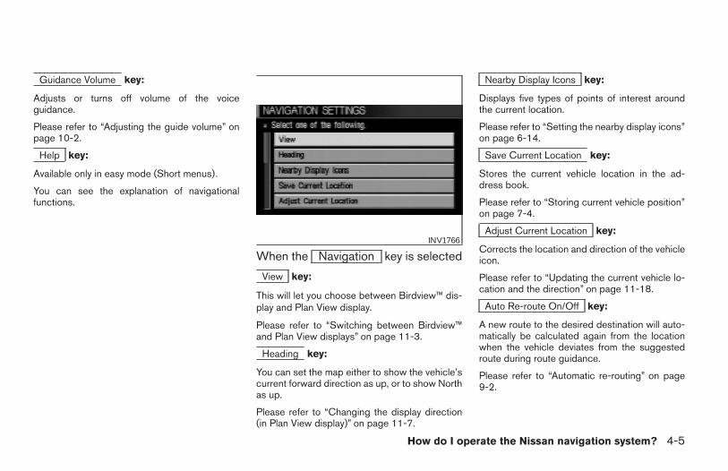
When the Navigation key is selected
View key:
This will let you choose between Birdview™ dis-play and Plan View display.
Please refer to “Switching between Birdview™and Plan View displays” on page 11-3.
Heading key:
You can set the map either to show the vehicle’scurrent forward direction as up, or to show Northas up.
Please refer to “Changing the display direction(in Plan View display)” on page 11-7.
Nearby Display Icons key:
Displays five types of points of interest aroundthe current location.
Please refer to “Setting the nearby display icons”on page 6-14.
Save Current Location key:
Stores the current vehicle location in the ad-dress book.
Please refer to “Storing current vehicle position”on page 7-4.
Adjust Current Location key:
Corrects the location and direction of the vehicleicon.
Please refer to “Updating the current vehicle lo-cation and the direction” on page 11-18.
Auto Re-route On/Off key:
A new route to the desired destination will auto-matically be calculated again from the locationwhen the vehicle deviates from the suggestedroute during route guidance.
Please refer to “Automatic re-routing” on page9-2.
INV1766
How do I operate the Nissan navigation system? 4-5
Z REVIEW COPY—2004 Maxima (max)Navigation System OM (navi)—USA_English (nna)04/27/04—tbrooks X
Avoid Area Setting key:
Defines areas to avoid when calculating a route.
Please refer to “Setting avoid areas” on page8-2.
Clear Memory key:
Clears all the stored memory (Address Book,Avoid Area, Previous Dest.).
Please refer to “Clearing the memory” on page4-16.
Edit Address Book key:
Changes the names and positions of the regis-tered locations.
Please refer to “Setting up and editing the ad-dress book” on page 7-2.
GPS Information key:
GPS information will be displayed.
Please refer to “GPS information display” onpage 11-17.
Quick Stop Customer Setting key:
Sets the user-defined [Quick Stop] POI (PointOf Interest).
Please refer to “Quick stop” on page 5-41.
Set Average Speed for Estimated Journey Timekey:
Please refer to “Setting the average speed” onpage 4-18.
Tracking On/Off key:
You can choose whether to display the path fromthe start to the current position.
Please refer to “Displaying the track” on page11-15.
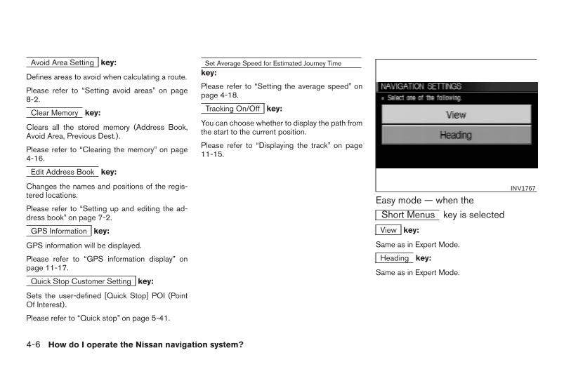
Easy mode — when the
Short Menus key is selected
View key:
Same as in Expert Mode.
Heading key:
Same as in Expert Mode.
INV1767
4-6 How do I operate the Nissan navigation system?
Z REVIEW COPY—2004 Maxima (max)Navigation System OM (navi)—USA_English (nna)04/27/04—tbrooks X
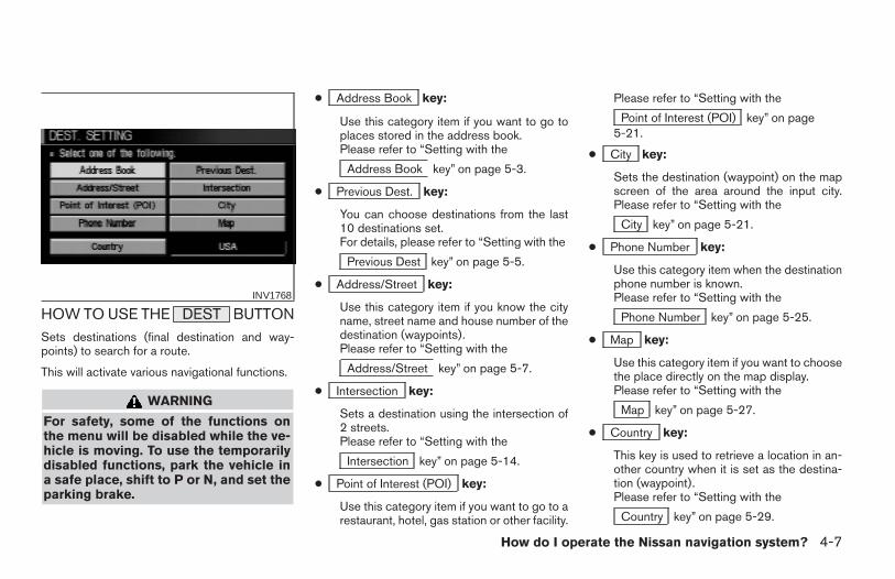
HOW TO USE THE DEST BUTTONSets destinations (final destination and way-points) to search for a route.
This will activate various navigational functions.
WARNING
For safety, some of the functions onthe menu will be disabled while the ve-hicle is moving. To use the temporarilydisabled functions, park the vehicle ina safe place, shift to P or N, and set theparking brake.
● Address Book key:
Use this category item if you want to go toplaces stored in the address book.Please refer to “Setting with the
Address Book key” on page 5-3.
● Previous Dest. key:
You can choose destinations from the last10 destinations set.For details, please refer to “Setting with the
Previous Dest key” on page 5-5.
● Address/Street key:
Use this category item if you know the cityname, street name and house number of thedestination (waypoints).Please refer to “Setting with the
Address/Street key” on page 5-7.
● Intersection key:
Sets a destination using the intersection of2 streets.Please refer to “Setting with the
Intersection key” on page 5-14.
● Point of Interest (POI) key:
Use this category item if you want to go to arestaurant, hotel, gas station or other facility.
Please refer to “Setting with the
Point of Interest (POI) key” on page5-21.
● City key:
Sets the destination (waypoint) on the mapscreen of the area around the input city.Please refer to “Setting with the
City key” on page 5-21.
● Phone Number key:
Use this category item when the destinationphone number is known.Please refer to “Setting with the
Phone Number key” on page 5-25.
● Map key:
Use this category item if you want to choosethe place directly on the map display.Please refer to “Setting with the
Map key” on page 5-27.
● Country key:
This key is used to retrieve a location in an-other country when it is set as the destina-tion (waypoint).Please refer to “Setting with the
Country key” on page 5-29.
INV1768
How do I operate the Nissan navigation system? 4-7
Z REVIEW COPY—2004 Maxima (max)Navigation System OM (navi)—USA_English (nna)04/27/04—tbrooks X
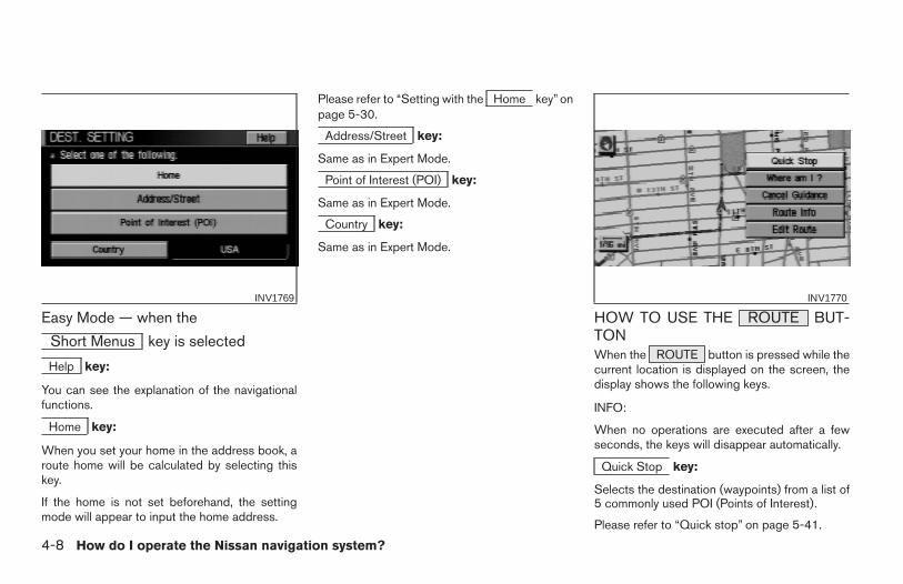
Easy Mode — when the
Short Menus key is selected
Help key:
You can see the explanation of the navigationalfunctions.
Home key:
When you set your home in the address book, aroute home will be calculated by selecting thiskey.
If the home is not set beforehand, the settingmode will appear to input the home address.
Please refer to “Setting with the Home key” onpage 5-30.
Address/Street key:
Same as in Expert Mode.
Point of Interest (POI) key:
Same as in Expert Mode.
Country key:
Same as in Expert Mode.
HOW TO USE THE ROUTE BUT-TONWhen the ROUTE button is pressed while thecurrent location is displayed on the screen, thedisplay shows the following keys.
INFO:
When no operations are executed after a fewseconds, the keys will disappear automatically.
Quick Stop key:
Selects the destination (waypoints) from a list of5 commonly used POI (Points of Interest).
Please refer to “Quick stop” on page 5-41.
INV1769 INV1770
4-8 How do I operate the Nissan navigation system?
Z REVIEW COPY—2004 Maxima (max)Navigation System OM (navi)—USA_English (nna)04/27/04—tbrooks X
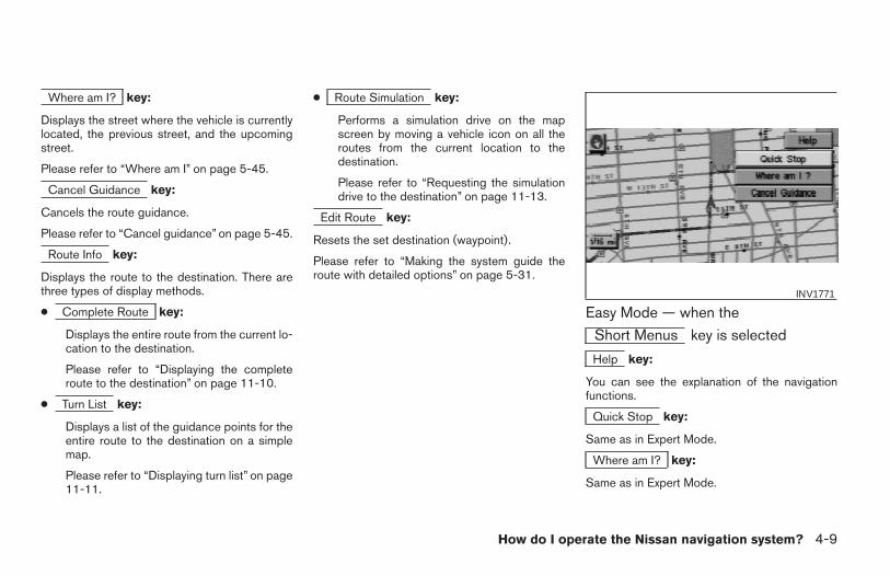
Where am I? key:
Displays the street where the vehicle is currentlylocated, the previous street, and the upcomingstreet.
Please refer to “Where am I” on page 5-45.
Cancel Guidance key:
Cancels the route guidance.
Please refer to “Cancel guidance” on page 5-45.
Route Info key:
Displays the route to the destination. There arethree types of display methods.
● Complete Route key:
Displays the entire route from the current lo-cation to the destination.
Please refer to “Displaying the completeroute to the destination” on page 11-10.
● Turn List key:
Displays a list of the guidance points for theentire route to the destination on a simplemap.
Please refer to “Displaying turn list” on page11-11.
● Route Simulation key:
Performs a simulation drive on the mapscreen by moving a vehicle icon on all theroutes from the current location to thedestination.
Please refer to “Requesting the simulationdrive to the destination” on page 11-13.
Edit Route key:
Resets the set destination (waypoint).
Please refer to “Making the system guide theroute with detailed options” on page 5-31.
Easy Mode — when the
Short Menus key is selected
Help key:
You can see the explanation of the navigationfunctions.
Quick Stop key:
Same as in Expert Mode.
Where am I? key:
Same as in Expert Mode.
INV1771
How do I operate the Nissan navigation system? 4-9
Z REVIEW COPY—2004 Maxima (max)Navigation System OM (navi)—USA_English (nna)04/27/04—tbrooks X
Cancel Guidance key:
Same as in Expert Mode.
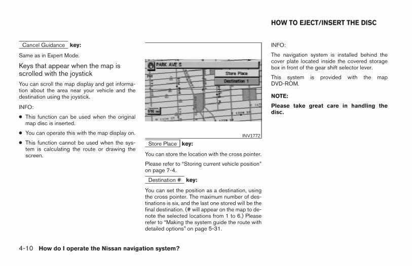
Keys that appear when the map isscrolled with the joystickYou can scroll the map display and get informa-tion about the area near your vehicle and thedestination using the joystick.
INFO:
● This function can be used when the originalmap disc is inserted.
● You can operate this with the map display on.
● This function cannot be used when the sys-tem is calculating the route or drawing thescreen.
Store Place key:
You can store the location with the cross pointer.
Please refer to “Storing current vehicle position”on page 7-4.
Destination # key:
You can set the position as a destination, usingthe cross pointer. The maximum number of des-tinations is six, and the last one stored will be thefinal destination. (# will appear on the map to de-note the selected locations from 1 to 6.) Pleaserefer to “Making the system guide the route withdetailed options” on page 5-31.
INFO:
The navigation system is installed behind thecover plate located inside the covered storagebox in front of the gear shift selector lever.
This system is provided with the mapDVD-ROM.
NOTE:
Please take great care in handling thedisc.
INV1772
HOW TO EJECT/INSERT THE DISC
4-10 How do I operate the Nissan navigation system?
Z REVIEW COPY—2004 Maxima (max)Navigation System OM (navi)—USA_English (nna)04/27/04—tbrooks X
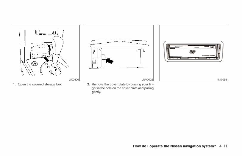
1. Open the covered storage box. 2. Remove the cover plate by placing your fin-ger in the hole on the cover plate and pullinggently.
LIC0406 LNV0002 INI0098
How do I operate the Nissan navigation system? 4-11
Z REVIEW COPY—2004 Maxima (max)Navigation System OM (navi)—USA_English (nna)04/27/04—tbrooks X
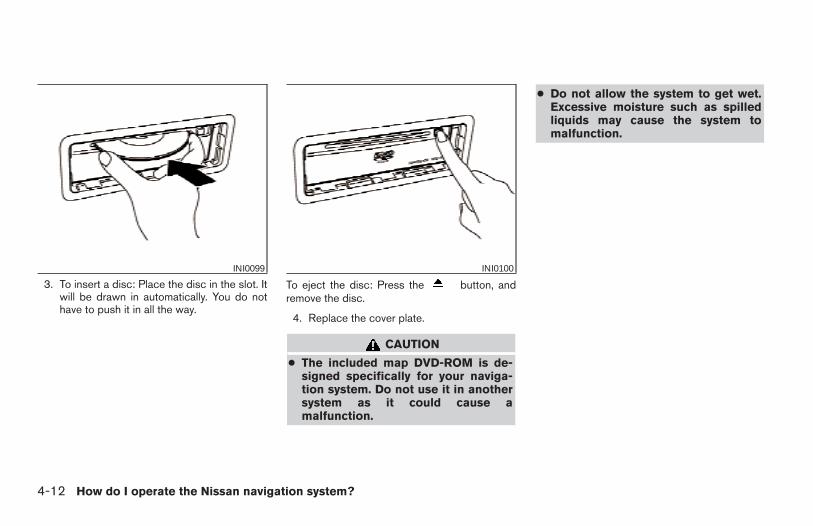
3. To insert a disc: Place the disc in the slot. Itwill be drawn in automatically. You do nothave to push it in all the way.
To eject the disc: Press the button, andremove the disc.
4. Replace the cover plate.
CAUTION
● The included map DVD-ROM is de-signed specifically for your naviga-tion system. Do not use it in anothersystem as it could cause amalfunction.
● Do not allow the system to get wet.Excessive moisture such as spilledliquids may cause the system tomalfunction.
INI0099 INI0100
4-12 How do I operate the Nissan navigation system?
Z REVIEW COPY—2004 Maxima (max)Navigation System OM (navi)—USA_English (nna)04/27/04—tbrooks X
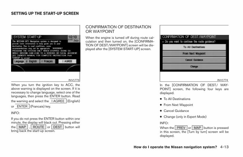
When you turn the ignition key to ACC, theabove warning is displayed on the screen. If it isnecessary to change language, select one of thelanguages, then press the ENTER button. Read
the warning and select the I AGREE (English)
or ENTER (Francais) key.
INFO:
If you do not press the ENTER button within oneminute, the display will black out. Pressing eitherthe MAP , ROUTE or DEST button willbring back the start-up screen.
CONFIRMATION OF DESTINATIONOR WAYPOINTWhen the engine is turned off during route cal-culation and then turned on, the [CONFIRMA-TION OF DEST./WAYPOINT] screen will be dis-played after the [SYSTEM START-UP] screen.
In the [CONFIRMATION OF DEST./ WAY-POINT] screen, the following four keys aredisplayed.
● To All Destinations
● From Next Waypoint
● Cancel Guidance
● Change (only in Expert Mode)
INFO:When the PREV or MAP button is pressedin this screen, the [Turn by turn] screen will bedisplayed.
INV1773 INV1774
SETTING UP THE START-UP SCREEN
How do I operate the Nissan navigation system? 4-13
Z REVIEW COPY—2004 Maxima (max)Navigation System OM (navi)—USA_English (nna)04/27/04—tbrooks X
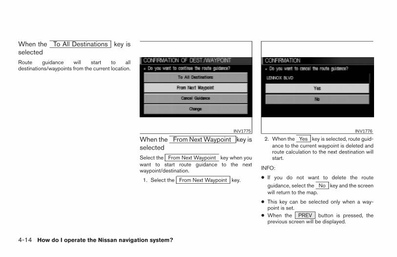
When the To All Destinations key isselectedRoute guidance will start to alldestinations/waypoints from the current location.
When the From Next Waypoint key isselectedSelect the From Next Waypoint key when youwant to start route guidance to the nextwaypoint/destination.
1. Select the From Next Waypoint key.
2. When the Yes key is selected, route guid-ance to the current waypoint is deleted androute calculation to the next destination willstart.
INFO:
● If you do not want to delete the route
guidance, select the No key and the screenwill return to the map.
● This key can be selected only when a way-point is set.
● When the PREV button is pressed, theprevious screen will be displayed.
INV1775 INV1776
4-14 How do I operate the Nissan navigation system?
Z REVIEW COPY—2004 Maxima (max)Navigation System OM (navi)—USA_English (nna)04/27/04—tbrooks X
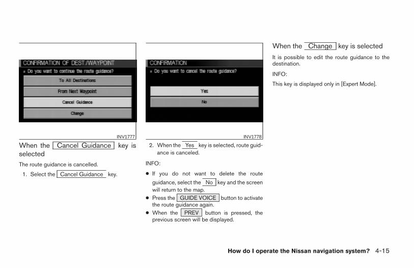
When the Cancel Guidance key isselectedThe route guidance is cancelled.
1. Select the Cancel Guidance key.
2. When the Yes key is selected, route guid-ance is canceled.
INFO:
● If you do not want to delete the route
guidance, select the No key and the screenwill return to the map.
● Press the GUIDE VOICE button to activatethe route guidance again.
● When the PREV button is pressed, theprevious screen will be displayed.
When the Change key is selected
It is possible to edit the route guidance to thedestination.
INFO:
This key is displayed only in [Expert Mode].
INV1777 INV1778
How do I operate the Nissan navigation system? 4-15
Z REVIEW COPY—2004 Maxima (max)Navigation System OM (navi)—USA_English (nna)04/27/04—tbrooks X
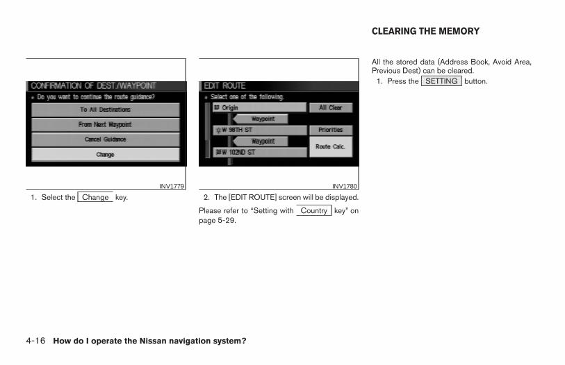
1. Select the Change key. 2. The [EDIT ROUTE] screen will be displayed.
Please refer to “Setting with Country key” onpage 5-29.
All the stored data (Address Book, Avoid Area,Previous Dest) can be cleared.
1. Press the SETTING button.
INV1779 INV1780
CLEARING THE MEMORY
4-16 How do I operate the Nissan navigation system?
Z REVIEW COPY—2004 Maxima (max)Navigation System OM (navi)—USA_English (nna)04/27/04—tbrooks X
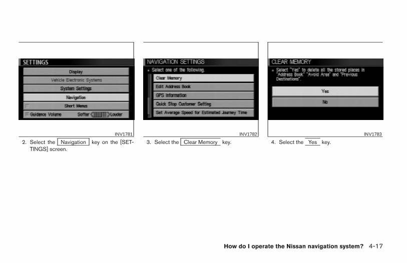
2. Select the Navigation key on the [SET-TINGS] screen.
3. Select the Clear Memory key. 4. Select the Yes key.INV1781 INV1782 INV1783
How do I operate the Nissan navigation system? 4-17
Z REVIEW COPY—2004 Maxima (max)Navigation System OM (navi)—USA_English (nna)04/27/04—tbrooks X
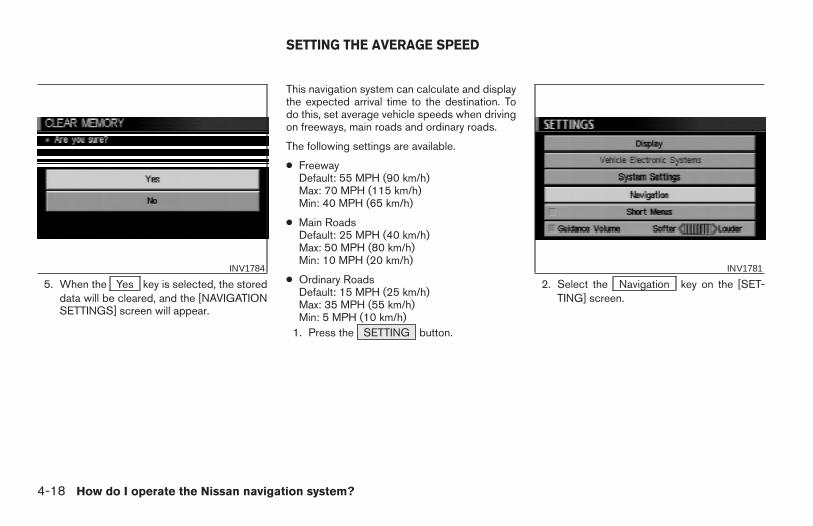
5. When the Yes key is selected, the storeddata will be cleared, and the [NAVIGATIONSETTINGS] screen will appear.
This navigation system can calculate and displaythe expected arrival time to the destination. Todo this, set average vehicle speeds when drivingon freeways, main roads and ordinary roads.
The following settings are available.
● FreewayDefault: 55 MPH (90 km/h)Max: 70 MPH (115 km/h)Min: 40 MPH (65 km/h)
● Main RoadsDefault: 25 MPH (40 km/h)Max: 50 MPH (80 km/h)Min: 10 MPH (20 km/h)
● Ordinary RoadsDefault: 15 MPH (25 km/h)Max: 35 MPH (55 km/h)Min: 5 MPH (10 km/h)
1. Press the SETTING button.
2. Select the Navigation key on the [SET-TING] screen.
INV1784 INV1781
SETTING THE AVERAGE SPEED
4-18 How do I operate the Nissan navigation system?
Z REVIEW COPY—2004 Maxima (max)Navigation System OM (navi)—USA_English (nna)04/27/04—tbrooks X
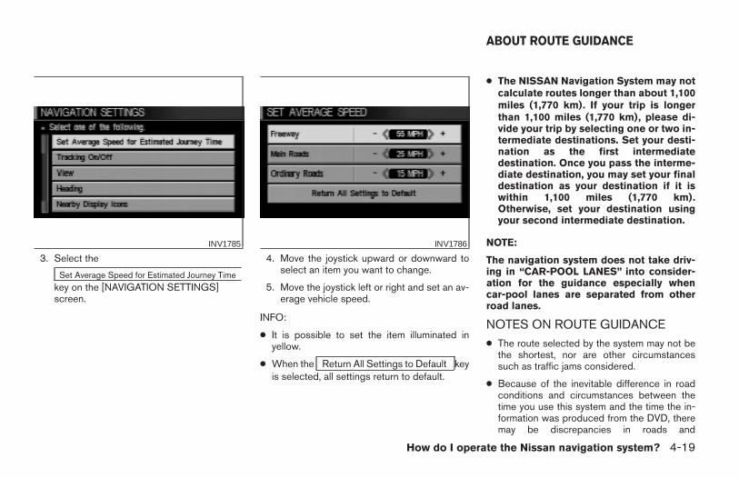
3. Select the
Set Average Speed for Estimated Journey Timekey on the [NAVIGATION SETTINGS]screen.
4. Move the joystick upward or downward toselect an item you want to change.
5. Move the joystick left or right and set an av-erage vehicle speed.
INFO:
● It is possible to set the item illuminated inyellow.
● When the Return All Settings to Default keyis selected, all settings return to default.
● The NISSAN Navigation System may notcalculate routes longer than about 1,100miles (1,770 km). If your trip is longerthan 1,100 miles (1,770 km), please di-vide your trip by selecting one or two in-termediate destinations. Set your desti-nation as the first intermediatedestination. Once you pass the interme-diate destination, you may set your finaldestination as your destination if it iswithin 1,100 miles (1,770 km).Otherwise, set your destination usingyour second intermediate destination.
NOTE:
The navigation system does not take driv-ing in “CAR-POOL LANES” into consider-ation for the guidance especially whencar-pool lanes are separated from otherroad lanes.
NOTES ON ROUTE GUIDANCE● The route selected by the system may not be
the shortest, nor are other circumstancessuch as traffic jams considered.
● Because of the inevitable difference in roadconditions and circumstances between thetime you use this system and the time the in-formation was produced from the DVD, theremay be discrepancies in roads and
INV1785 INV1786
ABOUT ROUTE GUIDANCE
How do I operate the Nissan navigation system? 4-19
Z REVIEW COPY—2004 Maxima (max)Navigation System OM (navi)—USA_English (nna)04/27/04—tbrooks X
regulations. In such cases, follow the actualinformation available.
● During route calculation, the map will notscroll, however the vehicle icon will move withthe actual vehicle’s movement.
● During route calculation, buttons such asMAP , DEST , ( ZOOM OUT )
and ( ZOOM IN ) and the joystick willbe disabled.
● In some cases, after the calculation iscomplete, it may take some time to get thecalculated route on the display.
● Waypoints that have been passed will not becovered by the re-routing calculation.
● If you scroll the map while the suggestedroute is being drawn, it may take more time tofinish drawing.
● If waypoints are set, the system is calculatingmultiple routes between waypointssimultaneously, and the following may result:
– If one section (or more) of the routes be-tween the waypoints is not found, noneof the route will be displayed.
– The route may not connect completely atsome waypoints.
– The route may require a U-turn close tosome waypoints.
● Route calculation may not be completed inthe following cases:
– If there is no main road within 3.1 miles(5 km) from the vehicle, a message say-ing so will appear on the screen. Try re-questing route calculation when the ve-hicle is closer to the main road.
– If there is no main road within 3.1 miles(5 km) from the destination or waypoint,a message saying so will appear on thescreen. Try setting the location closer tothe main road.
– If the vehicle is too close to the destina-tion or if there are no branches of theroads to the destination. A message say-ing so will appear on the screen.
– If it is deemed impossible to reach thedestination or waypoints because of traf-fic regulations, etc.
– If the only route to reach the destinationor waypoints is extremely complicated.
– If the destination, current vehicle positionor waypoint is within the avoid area.
– If the setting of avoid areas covers theroutes to the destination, route calcula-tion may not be possible.
● The following may occur when the route is be-ing displayed:
– If you are requesting a calculation fromthe main road, the origin of the route maynot exactly match the current vehicleposition.
– If you are requesting a calculation to adestination on the main road, the end ofthe route may not exactly match thedestination.
– If you are requesting a calculation fromthe main road, the system may show aroute from another main road. This maybe because the icon to show the currentvehicle position (vehicle icon) is not setaccurately. In that case, park the car in asafe place and reset the vehicle icon, orcontinue driving to see if the vehicle iconappears on the main road before re-questing route calculation again.
– There are cases in which the systemshows a detoured route to reach thedestination or waypoints, if you set themfrom memory or facility information. In or-der to correct this, you will have to be
4-20 How do I operate the Nissan navigation system?
Z REVIEW COPY—2004 Maxima (max)Navigation System OM (navi)—USA_English (nna)04/27/04—tbrooks X
careful about the traffic direction, espe-cially when the lanes with different traveldirections are shown separately. Suchplaces are interchanges and serviceareas.
– This system makes no distinction be-tween limited traffic control and totalcontrol (blockage). It may show a de-toured route even if the road is usable.
– Even if the freeway preference is set toOFF, the route may be set on them. Toavoid this, set a waypoint on anotherroad type and request calculation.
– Even if the preference is set as OFF for aferry line, the route may be set on it. Toavoid this, set a waypoint on a road andrequest calculation.
– Ferry lines, except those which acceptonly pedestrians, bicycles andmotorcycles, are stored in this system.When using them, take into consider-ation the travel time required and opera-tional condition to decide whether to usethem or not.
ABOUT THE DISPLAY ERROR
The following cases may affect the display accu-racy of the vehicle’s position or travel direction.The accuracy will return to normal if the drivingconditions return to normal:
– When there is a similar road nearby.
– When the vehicle is traveling on a long stretchof straight road or series of curves with a largeradius.
– When the vehicle is traveling in an area with acheckerboard road system.
– When the vehicle is making consecutive Scurves.
– When the vehicle is at a large Y-shapedjunction.
– When the vehicle is on a loop bridge.
– When the vehicle is on a snow-covered or un-paved road.
– When the vehicle has made several consecu-tive turns or zigzags.
– When the vehicle is rotated on a parking lotturntable while the ignition switch is OFF.
– Immediately after the vehicle is driven out of aparking garage or underground parking lot.
– When the vehicle has different sizes of tires ortire chains.
– When the vehicle is moved immediately afterthe engine is started.
How do I operate the Nissan navigation system? 4-21
Z REVIEW COPY—2004 Maxima (max)Navigation System OM (navi)—USA_English (nna)04/27/04—tbrooks X
4-22 How do I operate the Nissan navigation system?
MEMO
5 How do I program a destination?
Various ways to set the destination (or waypoint) . . . . . . 5-2Expert mode categories . . . . . . . . . . . . . . . . . . . . . . . . . 5-2Easy mode categories . . . . . . . . . . . . . . . . . . . . . . . . . . 5-3
Setting with the Address Book key . . . . . . . . . . . . . 5-3
Setting with the Previous Dest. key. . . . . . . . . . . . . 5-5
Setting with the Address/Street key . . . . . . . . . . . . 5-7
Setting with the Intersection key . . . . . . . . . . . . . . 5-14
Setting with thekey . . . . . . . . . . . . . . . . . . . . . . . . . . . . . . . . . . . . . . . . . .5-21
Setting with the City key . . . . . . . . . . . . . . . . . . . . . 5-21
Setting with the Phone Number key . . . . . . . . . . . 5-25
Setting with the Map key. . . . . . . . . . . . . . . . . . . . . 5-27
Setting with the Country key . . . . . . . . . . . . . . . . . 5-29
Setting with the Home key (in easy mode) . . . . . 5-30Having the system guide you to the destinations . . . . . 5-31
Making the system guide the route withdetailed options . . . . . . . . . . . . . . . . . . . . . . . . . . . . . . .5-31
Adjusting and deleting the pre-set destination(waypoints) . . . . . . . . . . . . . . . . . . . . . . . . . . . . . . . . . . . . . .5-38
To delete a destination . . . . . . . . . . . . . . . . . . . . . . . . . 5-39All clear . . . . . . . . . . . . . . . . . . . . . . . . . . . . . . . . . . . . . . . . .5-40Quick stop. . . . . . . . . . . . . . . . . . . . . . . . . . . . . . . . . . . . . . .5-41
Quick stop customer setting . . . . . . . . . . . . . . . . . . . . 5-43Where am I? . . . . . . . . . . . . . . . . . . . . . . . . . . . . . . . . . . . . .5-45Cancel guidance . . . . . . . . . . . . . . . . . . . . . . . . . . . . . . . . .5-45
When the All Destinations key is selected. . . . . . 5-46
When the Waypoint 1 key is selected . . . . . . . . . 5-46
When the Do not Cancel key is selected. . . . . . . 5-47
Z REVIEW COPY—2004 Maxima (max)Navigation System OM (navi)—USA_English (nna)04/27/04—tbrooks X
WARNING
To operate the navigation system or touse the screen functions, first park thevehicle in a safe place and set the park-ing brake. Using the system while driv-ing can distract the driver and may re-sult in a serious accident.
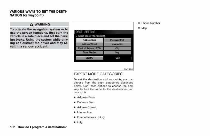
EXPERT MODE CATEGORIESTo set the destination and waypoints, you canchoose from the eight categories describedbelow. Use these options to choose the bestway to find the route to the destinations andwaypoints.
● Address Book
● Previous Dest
● Address/Street
● Intersection
● Point of Interest (POI)
● City
● Phone Number
● Map
INV1768
VARIOUS WAYS TO SET THE DESTI-NATION (or waypoint)
5-2 How do I program a destination?
Z REVIEW COPY—2004 Maxima (max)Navigation System OM (navi)—USA_English (nna)04/27/04—tbrooks X
EASY MODE CATEGORIESWhen the Expert Mode is canceled, the follow-ing three categories will be displayed as EasyMode.
● Home
● Address/Street
● Point of Interest (POI)
INFO:
● Use the Address/Street key and the
key in the same wayas in Expert Mode. Please refer to “Setting with
the Address/Street key” on page 5-3 and
“Setting with thekey” on page 6-2.
● If the Short Menus key is highlighted in am-ber in the [SETTING] screen, the screen is inEasy Mode. In this case, the keys displayed aredifferent from the screen in Expert Mode.
● If you set a destination or waypoints, they willbe displayed with icons.
● If you want to go to places close to the storedlocations or facilities, use categories such asfacility, nearby facility or memory for easiersetting.
● When using either the Point of Interest (POI)or nearby Points of Interest categories, thenames called up can be set as the destinationif you do not scroll the screen. If you want tochoose a different place on the screen fromthe one called up, you will have to scroll thescreen.
SETTING WITH THE
Address Book KEY
The Address Book will allow you to store loca-tions in the memory. This is especially useful forlocations that you visit frequently.
Please refer to “Setting up and editing the ad-dress book” on page 7-2.
INV1769
How do I program a destination? 5-3
Z REVIEW COPY—2004 Maxima (max)Navigation System OM (navi)—USA_English (nna)04/27/04—tbrooks X
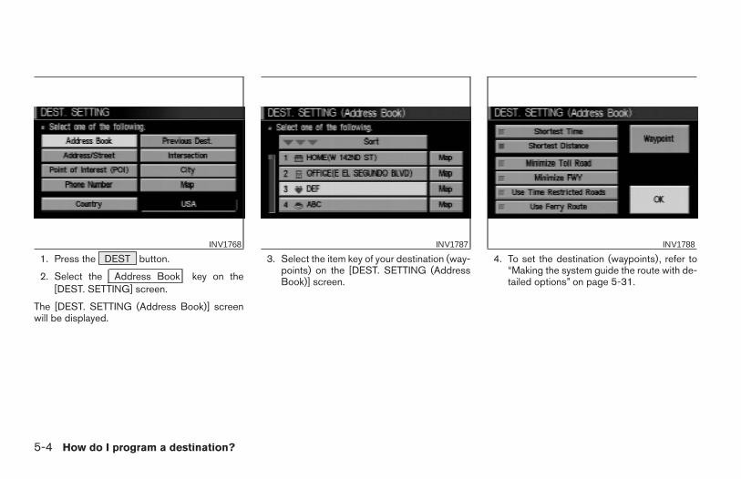
1. Press the DEST button.
2. Select the Address Book key on the[DEST. SETTING] screen.
The [DEST. SETTING (Address Book)] screenwill be displayed.
3. Select the item key of your destination (way-points) on the [DEST. SETTING (AddressBook)] screen.
4. To set the destination (waypoints), refer to“Making the system guide the route with de-tailed options” on page 5-31.
INV1768 INV1787 INV1788
5-4 How do I program a destination?
Z REVIEW COPY—2004 Maxima (max)Navigation System OM (navi)—USA_English (nna)04/27/04—tbrooks X
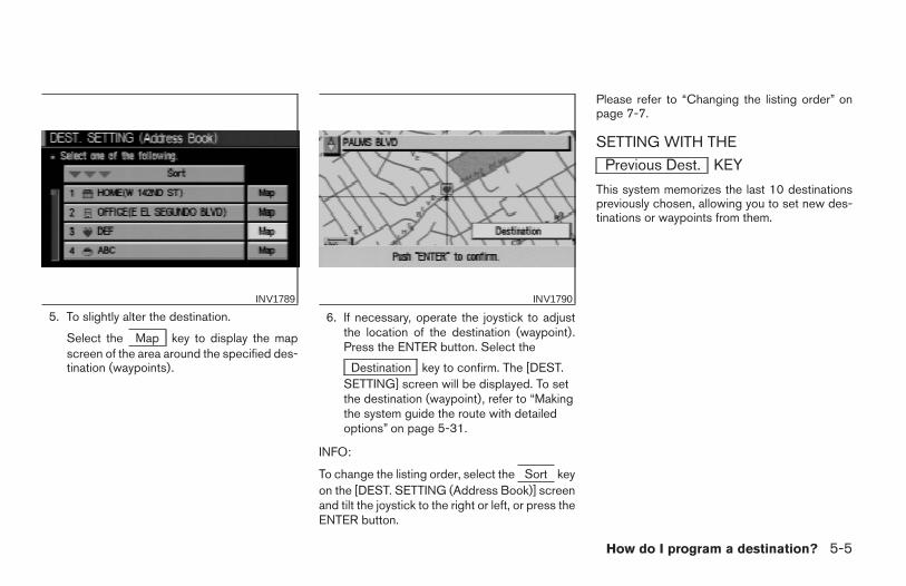
5. To slightly alter the destination.
Select the Map key to display the mapscreen of the area around the specified des-tination (waypoints).
6. If necessary, operate the joystick to adjustthe location of the destination (waypoint).Press the ENTER button. Select the
Destination key to confirm. The [DEST.SETTING] screen will be displayed. To setthe destination (waypoint), refer to “Makingthe system guide the route with detailedoptions” on page 5-31.
INFO:
To change the listing order, select the Sort keyon the [DEST. SETTING (Address Book)] screenand tilt the joystick to the right or left, or press theENTER button.
Please refer to “Changing the listing order” onpage 7-7.
SETTING WITH THE
Previous Dest. KEY
This system memorizes the last 10 destinationspreviously chosen, allowing you to set new des-tinations or waypoints from them.
INV1789 INV1790
How do I program a destination? 5-5
Z REVIEW COPY—2004 Maxima (max)Navigation System OM (navi)—USA_English (nna)04/27/04—tbrooks X
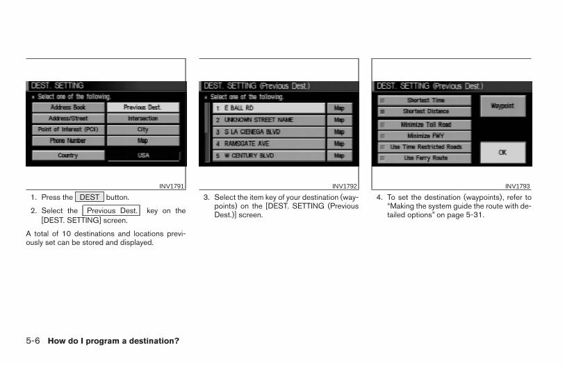
1. Press the DEST button.
2. Select the Previous Dest. key on the[DEST. SETTING] screen.
A total of 10 destinations and locations previ-ously set can be stored and displayed.
3. Select the item key of your destination (way-points) on the [DEST. SETTING (PreviousDest.)] screen.
4. To set the destination (waypoints), refer to“Making the system guide the route with de-tailed options” on page 5-31.
INV1791 INV1792 INV1793
5-6 How do I program a destination?
Z REVIEW COPY—2004 Maxima (max)Navigation System OM (navi)—USA_English (nna)04/27/04—tbrooks X

5. To fine tune the destination. Select the
Map key to display the map screen ofthe area around the specified destination(waypoints).
6. If necessary, operate the joystick to adjustthe location of the destination (waypoints).Press the ENTER button. Select the
Destination key to confirm. The [DEST.SETTING] screen will be displayed. To setthe destination (waypoints), refer to “Mak-ing the system guide the route with de-tailed options” on page 5-31.
SETTING WITH THE
Address/Street KEY
Sets the destination (waypoints) from the streetnames and addresses that you enter.
There are two search methods; direct search bythe street names, and search by the streetnames after the state and/or the city are defined.
INV1794 INV1795
How do I program a destination? 5-7
Z REVIEW COPY—2004 Maxima (max)Navigation System OM (navi)—USA_English (nna)04/27/04—tbrooks X
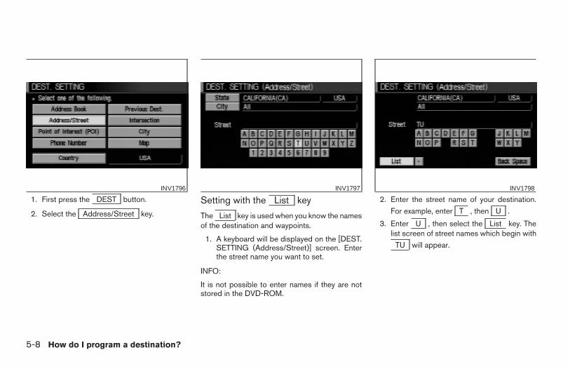
1. First press the DEST button.
2. Select the Address/Street key.
Setting with the List key
The List key is used when you know the namesof the destination and waypoints.
1. A keyboard will be displayed on the [DEST.SETTING (Address/Street)] screen. Enterthe street name you want to set.
INFO:
It is not possible to enter names if they are notstored in the DVD-ROM.
2. Enter the street name of your destination.
For example, enter T , then U .
3. Enter U , then select the List key. Thelist screen of street names which begin with
TU will appear.
INV1796 INV1797 INV1798
5-8 How do I program a destination?
Z REVIEW COPY—2004 Maxima (max)Navigation System OM (navi)—USA_English (nna)04/27/04—tbrooks X
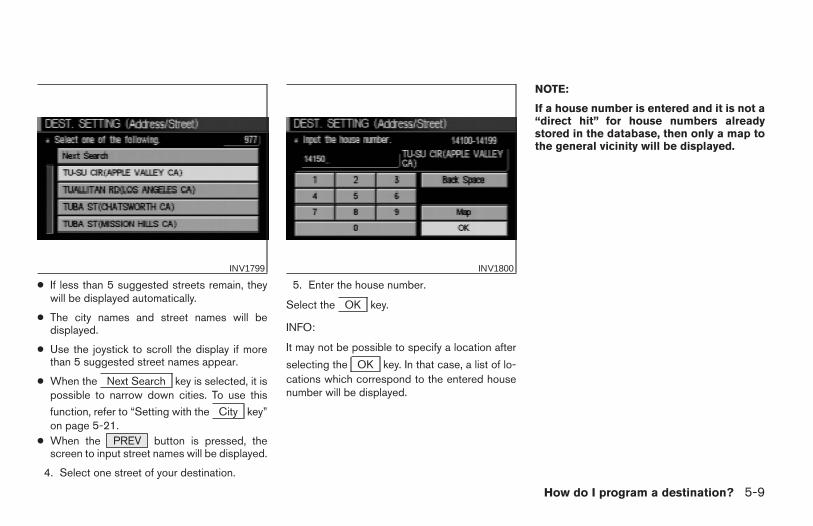
● If less than 5 suggested streets remain, theywill be displayed automatically.
● The city names and street names will bedisplayed.
● Use the joystick to scroll the display if morethan 5 suggested street names appear.
● When the Next Search key is selected, it ispossible to narrow down cities. To use this
function, refer to “Setting with the City key”on page 5-21.
● When the PREV button is pressed, thescreen to input street names will be displayed.
4. Select one street of your destination.
5. Enter the house number.
Select the OK key.
INFO:
It may not be possible to specify a location after
selecting the OK key. In that case, a list of lo-cations which correspond to the entered housenumber will be displayed.
NOTE:
If a house number is entered and it is not a“direct hit” for house numbers alreadystored in the database, then only a map tothe general vicinity will be displayed.
INV1799 INV1800
How do I program a destination? 5-9
Z REVIEW COPY—2004 Maxima (max)Navigation System OM (navi)—USA_English (nna)04/27/04—tbrooks X
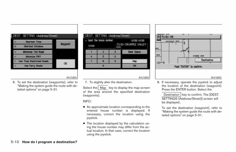
6. To set the destination (waypoints), refer to“Making the system guide the route with de-tailed options” on page 5-31.
7. To slightly alter the destination.
Select the Map key to display the map screenof the area around the specified destination(waypoints).
INFO:
● An approximate location corresponding to theentered house number is displayed. Ifnecessary, correct the location using thejoystick.
● The location displayed by the calculation us-ing the house number may differ from the ac-tual location. In that case, correct the locationusing the joystick.
8. If necessary, operate the joystick to adjustthe location of the destination (waypoint).Press the ENTER button. Select the
Destination key to confirm. The [DEST.SETTINGS (Address/Street)] screen willbe displayed..
To set the destination (waypoint), refer to“Making the system guide the route with de-tailed options” on page 5-31.
INV1801 INV1802 INV1803
5-10 How do I program a destination?
Z REVIEW COPY—2004 Maxima (max)Navigation System OM (navi)—USA_English (nna)04/27/04—tbrooks X
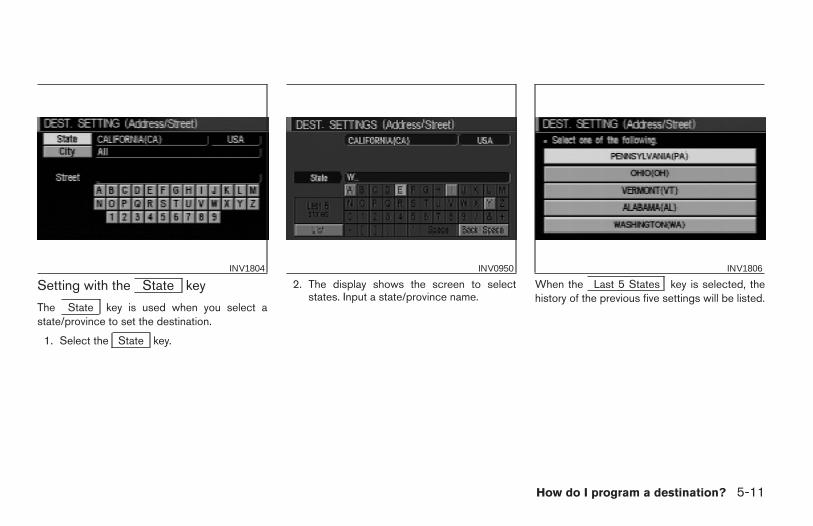
Setting with the State key
The State key is used when you select astate/province to set the destination.
1. Select the State key.
2. The display shows the screen to selectstates. Input a state/province name.
When the Last 5 States key is selected, thehistory of the previous five settings will be listed.
INV1804 INV0950 INV1806
How do I program a destination? 5-11
Z REVIEW COPY—2004 Maxima (max)Navigation System OM (navi)—USA_English (nna)04/27/04—tbrooks X
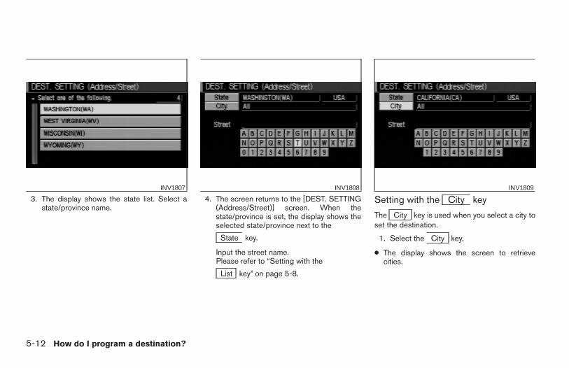
3. The display shows the state list. Select astate/province name.
4. The screen returns to the [DEST. SETTING(Address/Street)] screen. When thestate/province is set, the display shows theselected state/province next to the
State key.
Input the street name.Please refer to “Setting with the
List key” on page 5-8.
Setting with the City key
The City key is used when you select a city toset the destination.
1. Select the City key.
● The display shows the screen to retrievecities.
INV1807 INV1808 INV1809
5-12 How do I program a destination?
Z REVIEW COPY—2004 Maxima (max)Navigation System OM (navi)—USA_English (nna)04/27/04—tbrooks X
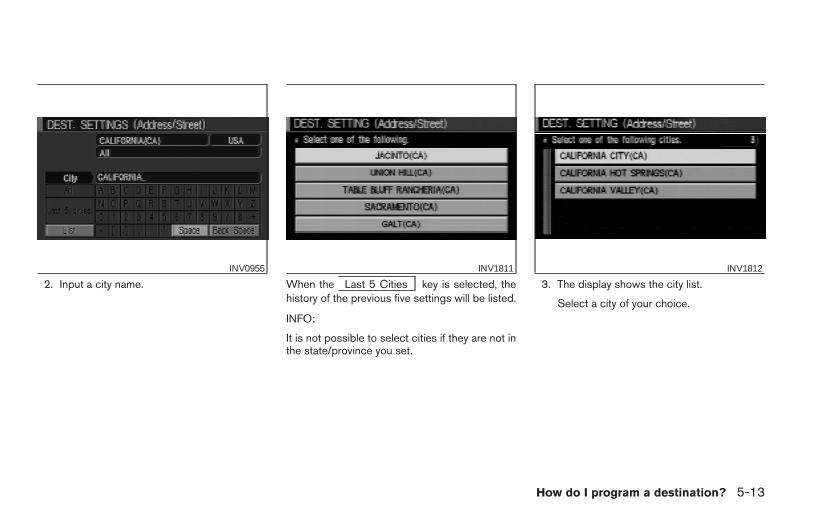
2. Input a city name. When the Last 5 Cities key is selected, thehistory of the previous five settings will be listed.
INFO:
It is not possible to select cities if they are not inthe state/province you set.
3. The display shows the city list.
Select a city of your choice.
INV0955 INV1811 INV1812
How do I program a destination? 5-13
Z REVIEW COPY—2004 Maxima (max)Navigation System OM (navi)—USA_English (nna)04/27/04—tbrooks X
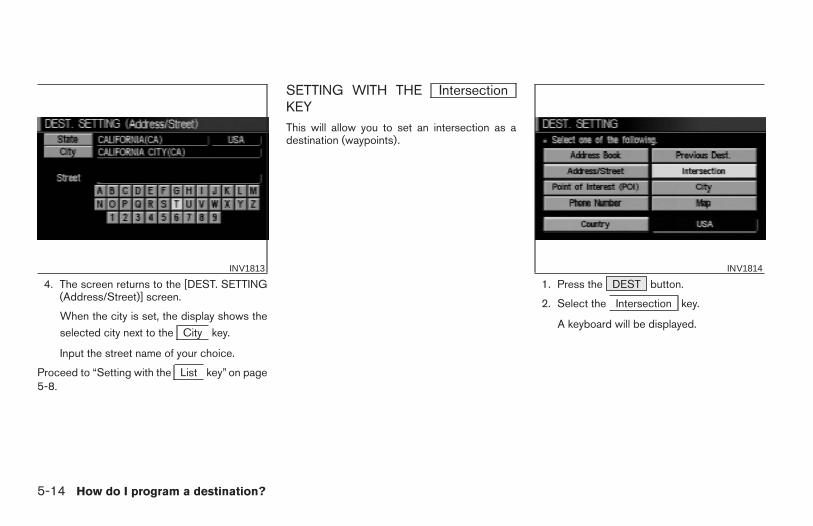
4. The screen returns to the [DEST. SETTING(Address/Street)] screen.
When the city is set, the display shows the
selected city next to the City key.
Input the street name of your choice.
Proceed to “Setting with the List key” on page5-8.
SETTING WITH THE IntersectionKEYThis will allow you to set an intersection as adestination (waypoints).
1. Press the DEST button.
2. Select the Intersection key.
A keyboard will be displayed.
INV1813 INV1814
5-14 How do I program a destination?
Z REVIEW COPY—2004 Maxima (max)Navigation System OM (navi)—USA_English (nna)04/27/04—tbrooks X
Setting with the List key
The List key is used when you know the namesof the destinations and waypoints.
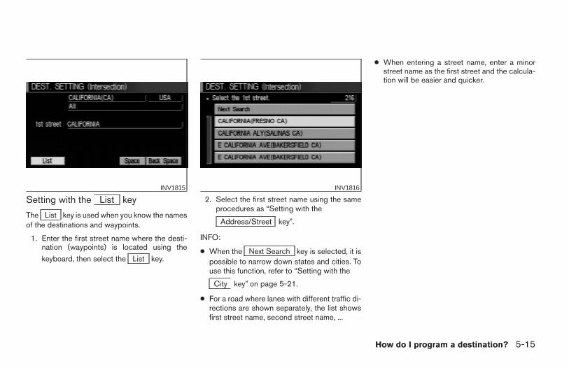
1. Enter the first street name where the desti-nation (waypoints) is located using the
keyboard, then select the List key.
2. Select the first street name using the sameprocedures as “Setting with the
Address/Street key”.
INFO:
● When the Next Search key is selected, it ispossible to narrow down states and cities. Touse this function, refer to “Setting with the
City key” on page 5-21.
● For a road where lanes with different traffic di-rections are shown separately, the list showsfirst street name, second street name, ...
● When entering a street name, enter a minorstreet name as the first street and the calcula-tion will be easier and quicker.
INV1815 INV1816
How do I program a destination? 5-15
Z REVIEW COPY—2004 Maxima (max)Navigation System OM (navi)—USA_English (nna)04/27/04—tbrooks X
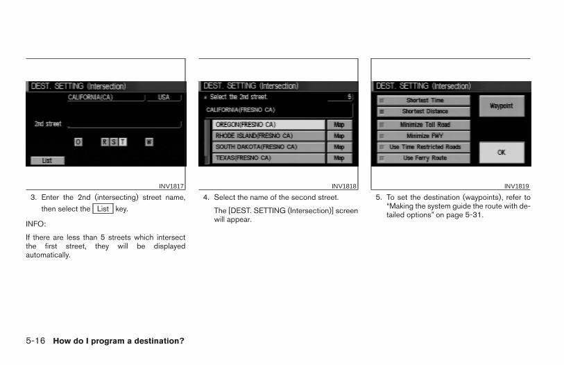
3. Enter the 2nd (intersecting) street name,
then select the List key.
INFO:
If there are less than 5 streets which intersectthe first street, they will be displayedautomatically.
4. Select the name of the second street.
The [DEST. SETTING (Intersection)] screenwill appear.
5. To set the destination (waypoints), refer to“Making the system guide the route with de-tailed options” on page 5-31.
INV1817 INV1818 INV1819
5-16 How do I program a destination?
Z REVIEW COPY—2004 Maxima (max)Navigation System OM (navi)—USA_English (nna)04/27/04—tbrooks X
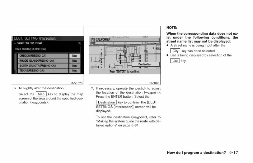
6. To slightly alter the destination.
Select the Map key to display the mapscreen of the area around the specified des-tination (waypoints).
7. If necessary, operate the joystick to adjustthe location of the destination (waypoint).Press the ENTER button. Select the
Destination key to confirm. The [DEST.SETTINGS (Intersection)] screen will bedisplayed.
To set the destination (waypoint), refer to“Making the system guide the route with de-tailed options” on page 5-31.
NOTE:
When the corresponding data does not ex-ist under the following conditions, thestreet name list may not be displayed:● A street name is being input after the
City key has been selected.● List is being displayed by selection of the
List key.
INV1820 INV1821
How do I program a destination? 5-17
Z REVIEW COPY—2004 Maxima (max)Navigation System OM (navi)—USA_English (nna)04/27/04—tbrooks X

Setting with the State key
The State key is used when you select astate/province to set the destination.
1. Select the State key.
2. The display shows the screen to selectstates.
Input a state/province name.
When the Last 5 States key is selected, thehistory of the previous five settings will be listed.
INV1822 INV1823 INV1824
5-18 How do I program a destination?
Z REVIEW COPY—2004 Maxima (max)Navigation System OM (navi)—USA_English (nna)04/27/04—tbrooks X
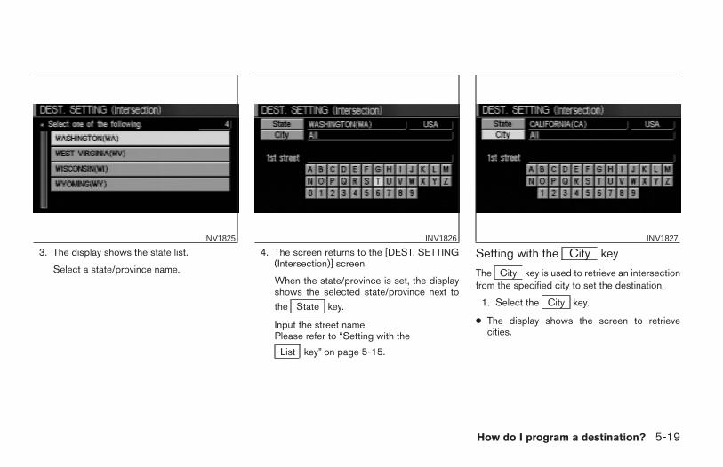
3. The display shows the state list.
Select a state/province name.
4. The screen returns to the [DEST. SETTING(Intersection)] screen.
When the state/province is set, the displayshows the selected state/province next to
the State key.
Input the street name.Please refer to “Setting with the
List key” on page 5-15.
Setting with the City key
The City key is used to retrieve an intersectionfrom the specified city to set the destination.
1. Select the City key.
● The display shows the screen to retrievecities.
INV1825 INV1826 INV1827
How do I program a destination? 5-19
Z REVIEW COPY—2004 Maxima (max)Navigation System OM (navi)—USA_English (nna)04/27/04—tbrooks X
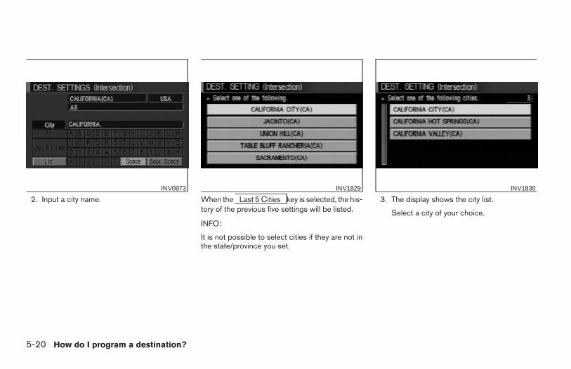
2. Input a city name. When the Last 5 Cities key is selected, the his-tory of the previous five settings will be listed.
INFO:
It is not possible to select cities if they are not inthe state/province you set.
3. The display shows the city list.
Select a city of your choice.
INV0973 INV1829 INV1830
5-20 How do I program a destination?
Z REVIEW COPY—2004 Maxima (max)Navigation System OM (navi)—USA_English (nna)04/27/04—tbrooks X
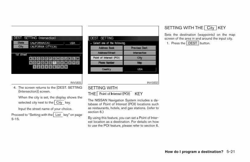
4. The screen returns to the [DEST. SETTING(Intersection)] screen.
When the city is set, the display shows the
selected city next to the City key.
Input the street name of your choice.
Proceed to “Setting with the List key” on page5-15.
SETTING WITHTHE KEYThe NISSAN Navigation System includes a da-tabase of Point of Interest (POI) locations suchas restaurants, hotels, and gas stations. (refer tosection 6.)
By using this feature, you can set a Point of Inter-est location as a destination. For details on howto use the POI feature, please refer to section 6.
SETTING WITH THE City KEY
Sets the destination (waypoints) on the mapscreen of the area in and around the input city.
1. Press the DEST button.
INV1831 INV1832
How do I program a destination? 5-21
Z REVIEW COPY—2004 Maxima (max)Navigation System OM (navi)—USA_English (nna)04/27/04—tbrooks X

2. Select the City key on the [DEST. SET-TING] screen.
Setting with the List key
The List key is used when you know the namesof the destination and waypoints.
1. Enter the characters of the city name whichyou wish to set as a destination (waypoints)using the keyboard on the [DEST. SETTING
(City)] screen, then select the List key.
INFO:
● When the List key is selected, the data ofthe currently-listed cities will be displayed.
● If less than 5 suggested cities remain, they willbe displayed automatically.
2. Select the city name of your destination(waypoints) on the [DEST. SETTING (City)]screen.
INV1833 INV1834 INV1835
5-22 How do I program a destination?
Z REVIEW COPY—2004 Maxima (max)Navigation System OM (navi)—USA_English (nna)04/27/04—tbrooks X
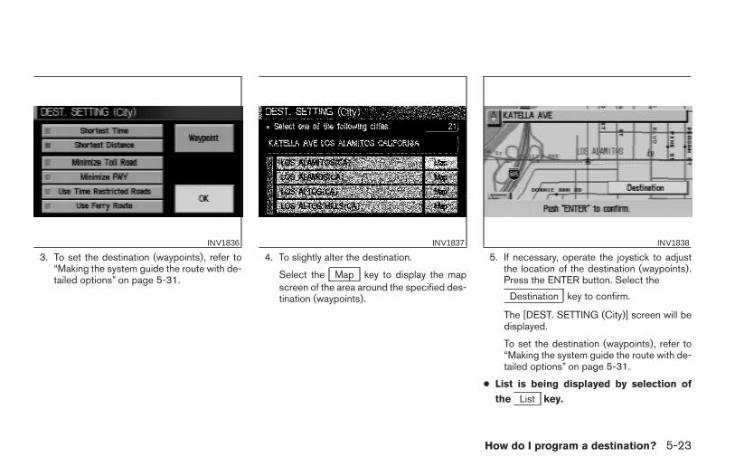
3. To set the destination (waypoints), refer to“Making the system guide the route with de-tailed options” on page 5-31.
4. To slightly alter the destination.
Select the Map key to display the mapscreen of the area around the specified des-tination (waypoints).
5. If necessary, operate the joystick to adjustthe location of the destination (waypoints).Press the ENTER button. Select the
Destination key to confirm.
The [DEST. SETTING (City)] screen will bedisplayed.
To set the destination (waypoints), refer to“Making the system guide the route with de-tailed options” on page 5-31.
● List is being displayed by selection of
the List key.
INV1836 INV1837 INV1838
How do I program a destination? 5-23
Z REVIEW COPY—2004 Maxima (max)Navigation System OM (navi)—USA_English (nna)04/27/04—tbrooks X
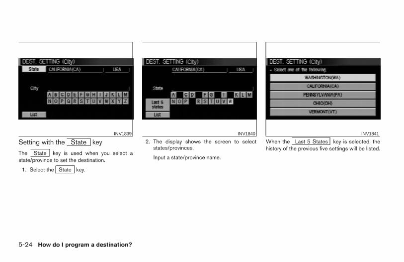
Setting with the State key
The State key is used when you select astate/province to set the destination.
1. Select the State key.
2. The display shows the screen to selectstates/provinces.
Input a state/province name.
When the Last 5 States key is selected, thehistory of the previous five settings will be listed.
INV1839 INV1840 INV1841
5-24 How do I program a destination?
Z REVIEW COPY—2004 Maxima (max)Navigation System OM (navi)—USA_English (nna)04/27/04—tbrooks X
3. The display shows the state/province list.
Select a state/province name.
4. The screen returns to the [DEST. SETTING(City)] screen.
When the state/province is set, the displayshows the selected state/province next to
the State key.
Input the street name.Please refer to “Setting with the
List key” on the previous section.
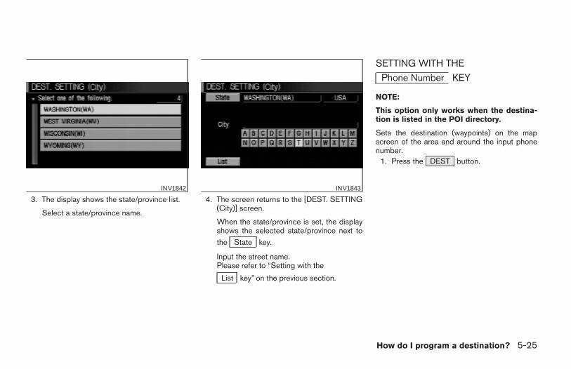
SETTING WITH THE
Phone Number KEY
NOTE:
This option only works when the destina-tion is listed in the POI directory.
Sets the destination (waypoints) on the mapscreen of the area and around the input phonenumber.
1. Press the DEST button.
INV1842 INV1843
How do I program a destination? 5-25
Z REVIEW COPY—2004 Maxima (max)Navigation System OM (navi)—USA_English (nna)04/27/04—tbrooks X
2. Select the Phone Number key on the[DEST. SETTING] screen.
3. Enter the ten digit phone number of thedestination (waypoints) using the keyboardon the [DEST. SETTING (Phone Number)]screen.
4. If you select the OK key, the [DEST. SET-TING (Phone Number)] screen will be dis-played.
5. To set the destination (waypoints), refer to“Making the system guide the route with de-tailed options” on page 5-31.
INV1844 INV1845 INV1846
5-26 How do I program a destination?
Z REVIEW COPY—2004 Maxima (max)Navigation System OM (navi)—USA_English (nna)04/27/04—tbrooks X
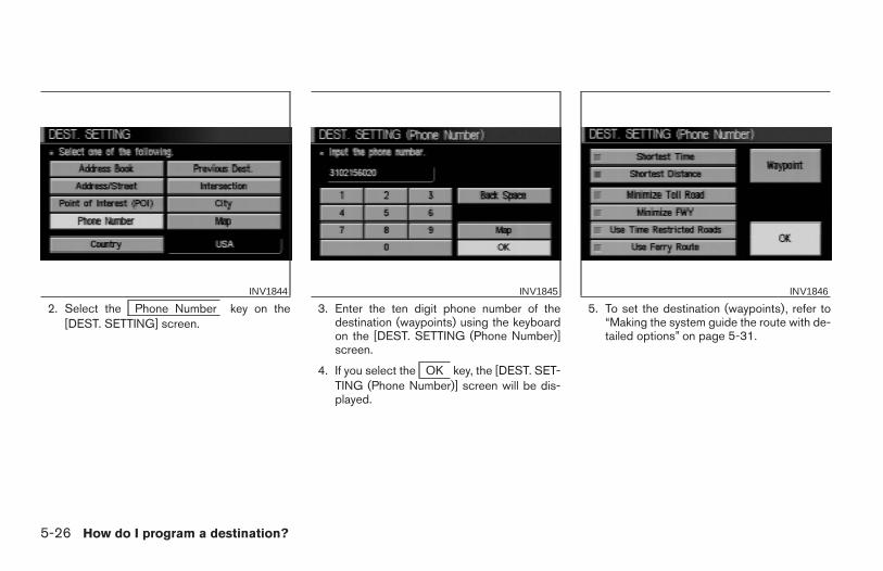
6. To slightly alter the destination.
Select the Map key to display the mapscreen of the area around the specified des-tination (waypoints).
7. If necessary, operate the joystick to adjustthe location of the destination (waypoints).
Press the ENTER button.
Select the Destination key to confirm.
To set the destination (waypoints), refer to“Making the system guide the route with de-tailed options” on page 5-31.
INFO:
When a hospital is set as a destination, a tele-phone number of the destination will bedisplayed.
SETTING WITH THE Map KEY
This will enable you to zoom into the map for de-tail and set the desired location. This works bestwhen you know the location geographically, orwant to check the geographical surroundings onthe map before setting the destinations.
INV1847 INV1848 INV1849
How do I program a destination? 5-27
Z REVIEW COPY—2004 Maxima (max)Navigation System OM (navi)—USA_English (nna)04/27/04—tbrooks X
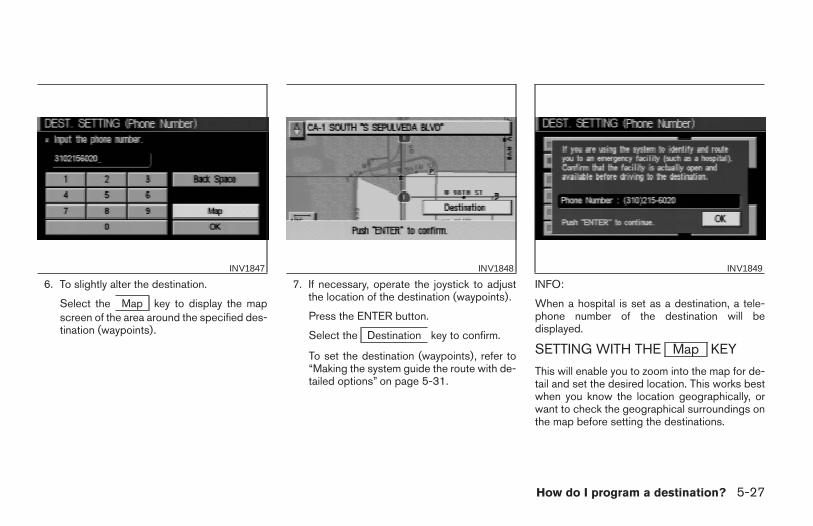
1. Press the DEST button.
2. Select the Map key.
The map of the entire area will be displayed.
3. Operate the joystick to choose the destina-tion (waypoints).
4. Adjust the location using the joystick, andpress the ENTER button.
5. Select the Destination key.
The [DEST. SETTING] screen will appear.
INV1850 INV1851 INV1852
5-28 How do I program a destination?
Z REVIEW COPY—2004 Maxima (max)Navigation System OM (navi)—USA_English (nna)04/27/04—tbrooks X
6. Please refer to “Making the system guidethe route with detailed options” on page5-31.
INFO:
When the OK key is selected in the [DEST.SETTING] screen, route calculation starts. If you
want to add waypoints, select the Waypointkey.
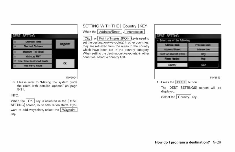
SETTING WITH THE Country KEYWhen the Address/Street , Intersection ,
City , or Point of Interest (POI) key is used toset the destination (waypoints) in other countries,they are retrieved from the areas in the countrywhich have been set in the country category.When setting the destination (waypoints) in othercountries, select a country first.
1. Press the DEST button.
The [DEST. SETTINGS] screen will bedisplayed.
Select the Country key.
INV2004 INV1853
How do I program a destination? 5-29
Z REVIEW COPY—2004 Maxima (max)Navigation System OM (navi)—USA_English (nna)04/27/04—tbrooks X
2. Select the Country key. Each time the EN-TER button is pressed, the country selectiontoggles between USA and Canada.
3. Then, the selected country will be displayed
at the right of the Country key.
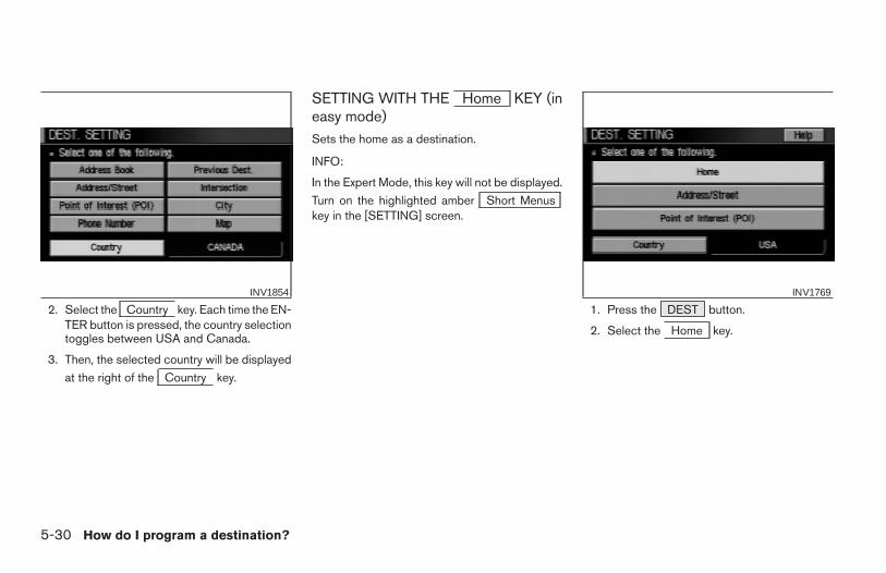
SETTING WITH THE Home KEY (ineasy mode)Sets the home as a destination.
INFO:
In the Expert Mode, this key will not be displayed.
Turn on the highlighted amber Short Menuskey in the [SETTING] screen.
1. Press the DEST button.
2. Select the Home key.
INV1854 INV1769
5-30 How do I program a destination?
Z REVIEW COPY—2004 Maxima (max)Navigation System OM (navi)—USA_English (nna)04/27/04—tbrooks X
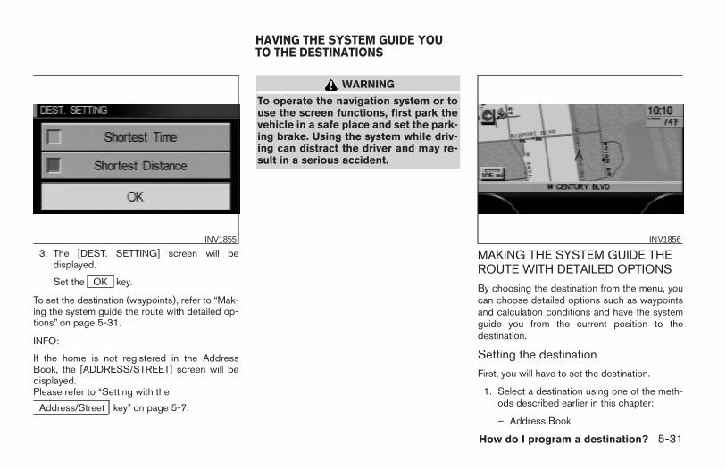
3. The [DEST. SETTING] screen will bedisplayed.
Set the OK key.
To set the destination (waypoints), refer to “Mak-ing the system guide the route with detailed op-tions” on page 5-31.
INFO:
If the home is not registered in the AddressBook, the [ADDRESS/STREET] screen will bedisplayed.Please refer to “Setting with the
Address/Street key” on page 5-7.
WARNING
To operate the navigation system or touse the screen functions, first park thevehicle in a safe place and set the park-ing brake. Using the system while driv-ing can distract the driver and may re-sult in a serious accident.
MAKING THE SYSTEM GUIDE THEROUTE WITH DETAILED OPTIONS
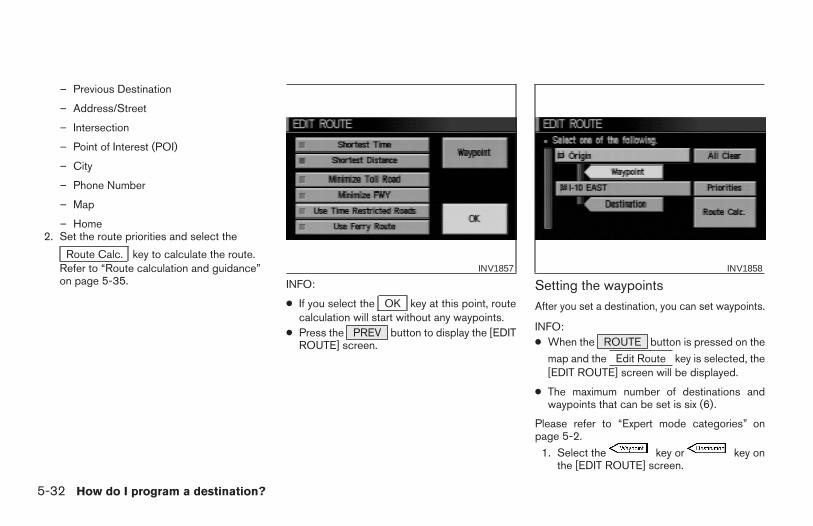
By choosing the destination from the menu, youcan choose detailed options such as waypointsand calculation conditions and have the systemguide you from the current position to thedestination.
Setting the destination
First, you will have to set the destination.
1. Select a destination using one of the meth-ods described earlier in this chapter:
– Address Book
INV1855 INV1856
HAVING THE SYSTEM GUIDE YOUTO THE DESTINATIONS
How do I program a destination? 5-31
Z REVIEW COPY—2004 Maxima (max)Navigation System OM (navi)—USA_English (nna)04/27/04—tbrooks X
– Previous Destination
– Address/Street
– Intersection
– Point of Interest (POI)
– City
– Phone Number
– Map
– Home2. Set the route priorities and select the
Route Calc. key to calculate the route.Refer to “Route calculation and guidance”on page 5-35. INFO:
● If you select the OK key at this point, routecalculation will start without any waypoints.
● Press the PREV button to display the [EDITROUTE] screen.
Setting the waypointsAfter you set a destination, you can set waypoints.
INFO:● When the ROUTE button is pressed on the
map and the Edit Route key is selected, the[EDIT ROUTE] screen will be displayed.
● The maximum number of destinations andwaypoints that can be set is six (6).
Please refer to “Expert mode categories” onpage 5-2.
1. Select the key or key onthe [EDIT ROUTE] screen.
INV1857 INV1858
5-32 How do I program a destination?
Z REVIEW COPY—2004 Maxima (max)Navigation System OM (navi)—USA_English (nna)04/27/04—tbrooks X
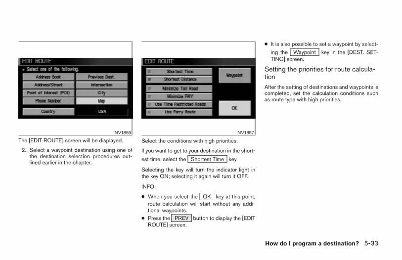
The [EDIT ROUTE] screen will be displayed.
2. Select a waypoint destination using one ofthe destination selection procedures out-lined earlier in the chapter.
Select the conditions with high priorities.
If you want to get to your destination in the short-
est time, select the Shortest Time key.
Selecting the key will turn the indicator light inthe key ON; selecting it again will turn it OFF.
INFO:
● When you select the OK key at this point,route calculation will start without any addi-tional waypoints.
● Press the PREV button to display the [EDITROUTE] screen.
● It is also possible to set a waypoint by select-
ing the Waypoint key in the [DEST. SET-TING] screen.
Setting the priorities for route calcula-tionAfter the setting of destinations and waypoints iscompleted, set the calculation conditions suchas route type with high priorities.
INV1859 INV1857
How do I program a destination? 5-33
Z REVIEW COPY—2004 Maxima (max)Navigation System OM (navi)—USA_English (nna)04/27/04—tbrooks X
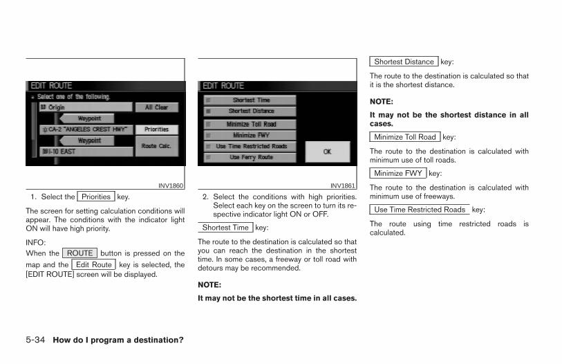
1. Select the Priorities key.
The screen for setting calculation conditions willappear. The conditions with the indicator lightON will have high priority.
INFO:When the ROUTE button is pressed on the
map and the Edit Route key is selected, the[EDIT ROUTE] screen will be displayed.
2. Select the conditions with high priorities.Select each key on the screen to turn its re-spective indicator light ON or OFF.
Shortest Time key:
The route to the destination is calculated so thatyou can reach the destination in the shortesttime. In some cases, a freeway or toll road withdetours may be recommended.
NOTE:
It may not be the shortest time in all cases.
Shortest Distance key:
The route to the destination is calculated so thatit is the shortest distance.
NOTE:
It may not be the shortest distance in allcases.
Minimize Toll Road key:
The route to the destination is calculated withminimum use of toll roads.
Minimize FWY key:
The route to the destination is calculated withminimum use of freeways.
Use Time Restricted Roads key:
The route using time restricted roads iscalculated.
INV1860 INV1861
5-34 How do I program a destination?
Z REVIEW COPY—2004 Maxima (max)Navigation System OM (navi)—USA_English (nna)04/27/04—tbrooks X
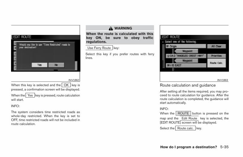
When this key is selected and the OK key ispressed, a confirmation screen will be displayed.
When the Yes key is pressed, route calculationwill start.
INFO:
The system considers time restricted roads aswhole-day restricted. When the key is set toOFF, time restricted roads will not be included inroute calculation.
WARNING
When the route is calculated with thiskey ON, be sure to obey trafficregulations.
Use Ferry Route key:
Select this key if you prefer routes with ferrylines.
Route calculation and guidanceAfter setting all the items required, you may pro-ceed to route calculation for guidance. After theroute calculation is completed, the guidance willstart automatically.
INFO:When the ROUTE button is pressed on the
map and the Edit Route key is selected, the[EDIT ROUTE] screen will be displayed.
Select the Route calc. key.
INV1862 INV1863
How do I program a destination? 5-35
Z REVIEW COPY—2004 Maxima (max)Navigation System OM (navi)—USA_English (nna)04/27/04—tbrooks X
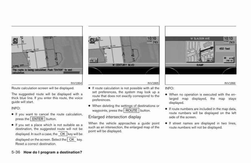
Route calculation screen will be displayed.
The suggested route will be displayed with athick blue line. If you enter this route, the voiceguide will start.
INFO:
● If you want to cancel the route calculation,press the ENTER button.
● If you set a place which is not suitable as adestination, the suggested route will not be
displayed. In such a case, the OK key will be
displayed on the screen. Select the OK key.Reset a correct destination.
● If route calculation is not possible with all theset preferences, the system may look up aroute that does not exactly correspond to thepreferences.
● When deleting the settings of destinations orwaypoints, press the ROUTE button.
Enlarged intersection displayWhen the vehicle approaches a guide pointsuch as an intersection, the enlarged map of thepoint will be displayed.
INFO:
● When no operation is executed with the en-larged map displayed, the map staysdisplayed.
● If route numbers are included in the map data,route numbers will be displayed on the leftside of the screen.
● If street names are displayed in two lines,route numbers will not be displayed.
INV1864 INV1865 INV1866
5-36 How do I program a destination?
Z REVIEW COPY—2004 Maxima (max)Navigation System OM (navi)—USA_English (nna)04/27/04—tbrooks X
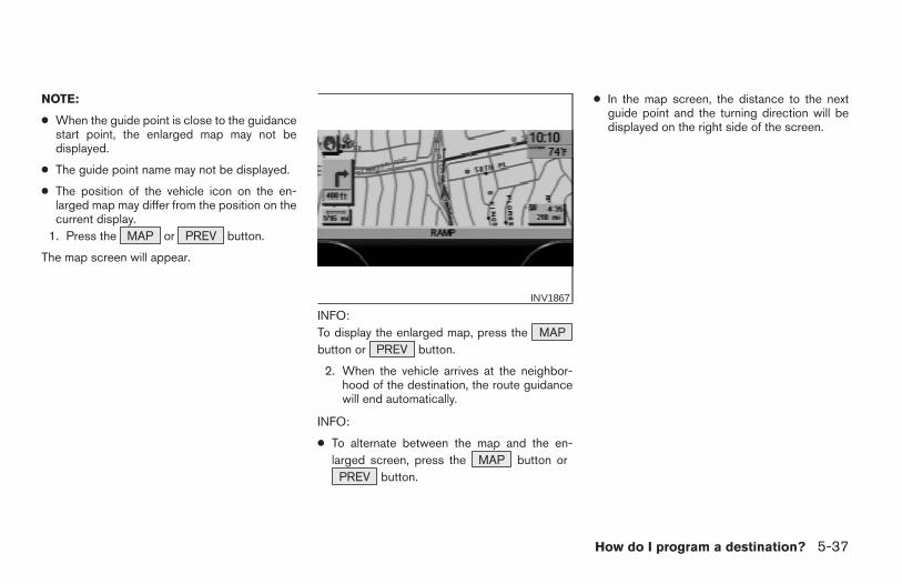
NOTE:
● When the guide point is close to the guidancestart point, the enlarged map may not bedisplayed.
● The guide point name may not be displayed.
● The position of the vehicle icon on the en-larged map may differ from the position on thecurrent display.
1. Press the MAP or PREV button.
The map screen will appear.
INFO:To display the enlarged map, press the MAPbutton or PREV button.
2. When the vehicle arrives at the neighbor-hood of the destination, the route guidancewill end automatically.
INFO:
● To alternate between the map and the en-larged screen, press the MAP button or
PREV button.
● In the map screen, the distance to the nextguide point and the turning direction will bedisplayed on the right side of the screen.
INV1867
How do I program a destination? 5-37
Z REVIEW COPY—2004 Maxima (max)Navigation System OM (navi)—USA_English (nna)04/27/04—tbrooks X
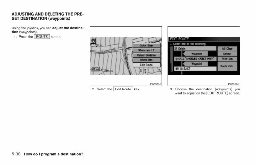
Using the joystick, you can adjust the destina-tion (waypoints).
1. Press the ROUTE button.
2. Select the Edit Route key. 3. Choose the destination (waypoints) youwant to adjust on the [EDIT ROUTE] screen.
INV1868 INV1869
ADJUSTING AND DELETING THE PRE-SET DESTINATION (waypoints)
5-38 How do I program a destination?
Z REVIEW COPY—2004 Maxima (max)Navigation System OM (navi)—USA_English (nna)04/27/04—tbrooks X
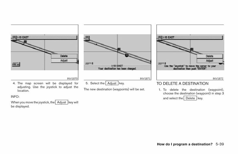
4. The map screen will be displayed foradjusting. Use the joystick to adjust thelocation.
INFO:
When you move the joystick, the Adjust key willbe displayed.
5. Select the Adjust key.
The new destination (waypoints) will be set.
TO DELETE A DESTINATION1. To delete the destination (waypoint),
choose the destination (waypoint) in step 3
and select the Delete key.
INV1870 INV1871 INV1872
How do I program a destination? 5-39
Z REVIEW COPY—2004 Maxima (max)Navigation System OM (navi)—USA_English (nna)04/27/04—tbrooks X
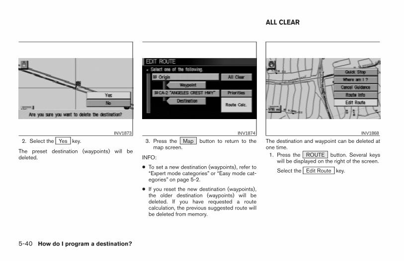
2. Select the Yes key.
The preset destination (waypoints) will bedeleted.
3. Press the Map button to return to themap screen.
INFO:
● To set a new destination (waypoints), refer to“Expert mode categories” or “Easy mode cat-egories” on page 5-2.
● If you reset the new destination (waypoints),the older destination (waypoints) will bedeleted. If you have requested a routecalculation, the previous suggested route willbe deleted from memory.
The destination and waypoint can be deleted atone time.
1. Press the ROUTE button. Several keyswill be displayed on the right of the screen.
Select the Edit Route key.
INV1873 INV1874 INV1868
ALL CLEAR
5-40 How do I program a destination?
Z REVIEW COPY—2004 Maxima (max)Navigation System OM (navi)—USA_English (nna)04/27/04—tbrooks X
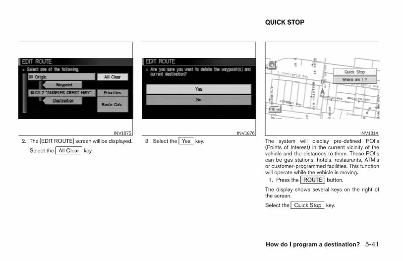
2. The [EDIT ROUTE] screen will be displayed.
Select the All Clear key.
3. Select the Yes key. The system will display pre-defined POI’s(Points of Interest) in the current vicinity of thevehicle and the distances to them. These POI’scan be gas stations, hotels, restaurants, ATM’sor customer-programmed facilities. This functionwill operate while the vehicle is moving.
1. Press the ROUTE button.
The display shows several keys on the right ofthe screen.
Select the Quick Stop key.
INV1875 INV1876 INV1314
QUICK STOP
How do I program a destination? 5-41
Z REVIEW COPY—2004 Maxima (max)Navigation System OM (navi)—USA_English (nna)04/27/04—tbrooks X
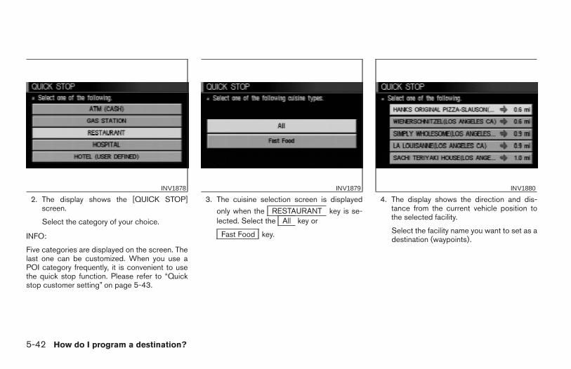
2. The display shows the [QUICK STOP]screen.
Select the category of your choice.
INFO:
Five categories are displayed on the screen. Thelast one can be customized. When you use aPOI category frequently, it is convenient to usethe quick stop function. Please refer to “Quickstop customer setting” on page 5-43.
3. The cuisine selection screen is displayed
only when the RESTAURANT key is se-lected. Select the All key or
Fast Food key.
4. The display shows the direction and dis-tance from the current vehicle position tothe selected facility.
Select the facility name you want to set as adestination (waypoints).
INV1878 INV1879 INV1880
5-42 How do I program a destination?
Z REVIEW COPY—2004 Maxima (max)Navigation System OM (navi)—USA_English (nna)04/27/04—tbrooks X
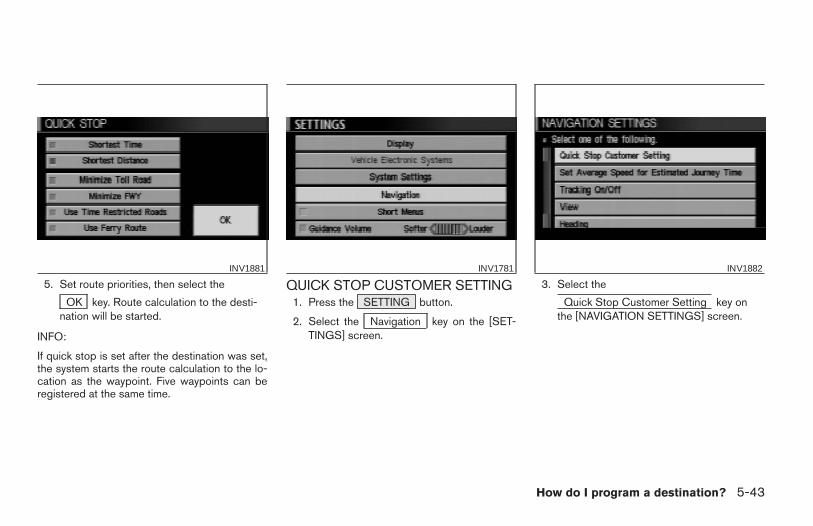
5. Set route priorities, then select the
OK key. Route calculation to the desti-nation will be started.
INFO:
If quick stop is set after the destination was set,the system starts the route calculation to the lo-cation as the waypoint. Five waypoints can beregistered at the same time.
QUICK STOP CUSTOMER SETTING1. Press the SETTING button.
2. Select the Navigation key on the [SET-TINGS] screen.
3. Select the
Quick Stop Customer Setting key onthe [NAVIGATION SETTINGS] screen.
INV1881 INV1781 INV1882
How do I program a destination? 5-43
Z REVIEW COPY—2004 Maxima (max)Navigation System OM (navi)—USA_English (nna)04/27/04—tbrooks X
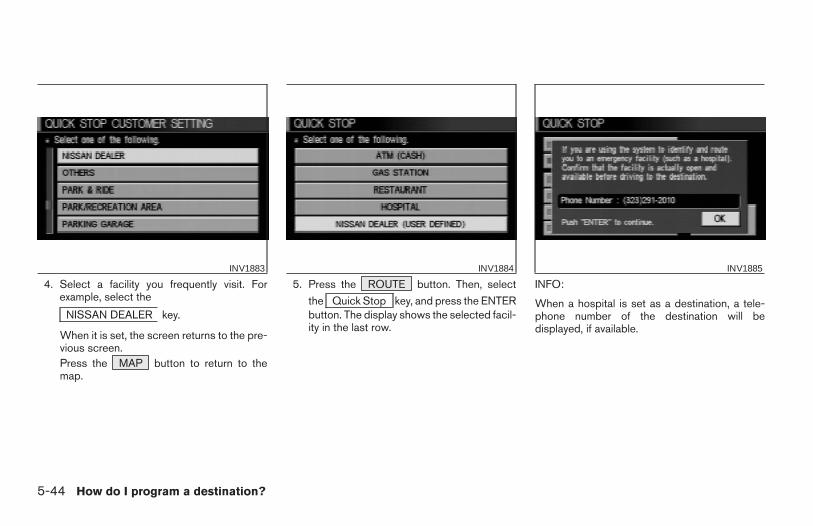
4. Select a facility you frequently visit. Forexample, select the
NISSAN DEALER key.
When it is set, the screen returns to the pre-vious screen.Press the MAP button to return to themap.
5. Press the ROUTE button. Then, select
the Quick Stop key, and press the ENTERbutton. The display shows the selected facil-ity in the last row.
INFO:
When a hospital is set as a destination, a tele-phone number of the destination will bedisplayed, if available.
INV1883 INV1884 INV1885
5-44 How do I program a destination?
Z REVIEW COPY—2004 Maxima (max)Navigation System OM (navi)—USA_English (nna)04/27/04—tbrooks X
This key is used to find the name of the street onwhich the vehicle is currently located.
1. Press the ROUTE button.
Several keys appear on the right of the screen.
Select the Where am I? key.
2. The display shows the [WHERE AM I ?]screen, which includes the next, current,and previous streets. Each one shows thestreets which the vehicle is approaching,currently traveling on, and those streets thevehicle was previously traveling on. Pressthe MAP or PREV button to return tothe map.
1. Press the ROUTE button.
2. Several keys appear on the right of thescreen. Select the
Cancel Guidance key.
INV1887 INV1888 INV1889
WHERE AM I? CANCEL GUIDANCE
How do I program a destination? 5-45
Z REVIEW COPY—2004 Maxima (max)Navigation System OM (navi)—USA_English (nna)04/27/04—tbrooks X
The [CONFIRMATION] screen is displayed withthe following three keys.
● All Destinations
● Waypoint 1 or Waypoint
● Do not Cancel
WHEN THE All Destinations KEY ISSELECTEDThe route guidance is turned off temporarily.
1. Select the All Destinations key.
2. When the Yes key is selected, the routeguidance is turned off.
INFO:
● When the No key is selected, the map will
be displayed. When the PREV button ispressed, the previous screen will be displayed.
● To restart the route guidance, press theGUIDE VOICE button.
WHEN THE Waypoint 1 KEY IS SE-LECTED
INFO:
This key can be selected only when a waypoint isset.
Route guidance to the next waypoint is deleted.
INV1890 INV1891
5-46 How do I program a destination?
Z REVIEW COPY—2004 Maxima (max)Navigation System OM (navi)—USA_English (nna)04/27/04—tbrooks X
1. Select the Waypoint 1 key.
2. When the Yes key is selected, thewaypoint is deleted and route calculation willstart.
INFO:
When the No key is selected, the map will be
displayed. When the PREV button is pressed,the previous screen will be displayed.
WHEN THE Do not Cancel KEY ISSELECTEDThe [CONFIRMATION] screen will return to themap screen.
INV1892
How do I program a destination? 5-47
Z REVIEW COPY—2004 Maxima (max)Navigation System OM (navi)—USA_English (nna)04/27/04—tbrooks X

5-48 How do I program a destination?
MEMO
6 How do I use the Point of Interest (POI)feature?
Setting with the key. . . . . . . . . . 6-2
Setting with the List key . . . . . . . . . . . . . . . . . . . . . . 6-2
Setting with the Category key . . . . . . . . . . . . . . . . . 6-5
Setting with the State key . . . . . . . . . . . . . . . . . . . . . 6-7
Setting with the City key . . . . . . . . . . . . . . . . . . . . . . 6-9
Setting with the Nearby key . . . . . . . . . . . . . . . . . . 6-12POI categories . . . . . . . . . . . . . . . . . . . . . . . . . . . . . . . . . . .6-13Setting the nearby display icons. . . . . . . . . . . . . . . . . . . . 6-14
Z REVIEW COPY—2004 Maxima (max)Navigation System OM (navi)—USA_English (nna)04/27/04—tbrooks X
The keys in Point of Interest (POI) are:
● List
● Category
● State/Province
● City
● Nearby
1. First press the DEST button.
2. Select the key onthe [DEST. SETTING] screen.
SETTING WITH THE List KEY
The List key is used when you know the exactnames of the destinations and waypoints.
1. Input the facility name for your destination.
NOTE:
For a quicker search, input thestate/province, city and category beforesearching for your desired destination.
INFO:
If the system detects that the number of corre-sponding facilities or cities is five or less, the dis-play shows the list screen automatically.
INV1832 INV1893
SETTING WITH THEKEY
6-2 How do I use the Point of Interest (POI) feature?
Z REVIEW COPY—2004 Maxima (max)Navigation System OM (navi)—USA_English (nna)04/27/04—tbrooks X
2. The display shows the screen to select a fa-
cility or Info key.
When the Next Search key is selected, it ispossible to narrow down categories,states/provinces and cities.To use this function, refer to “Setting with the
Category key”, “Setting with the State key”
and “Setting with the City key” on pages 6-5,6-7 and 6-9.
3. When a facility name is selected, the displayshows the [DEST. SETTING (POI)] screento set the destination.
Select the OK key to enter the priorities
selected. Select Waypoint to set thecloser destination as a waypoint.
Please refer to “Making the system guidethe route with detailed options” on page5-31.
INV1894 INV1895 INV1896
How do I use the Point of Interest (POI) feature? 6-3
Z REVIEW COPY—2004 Maxima (max)Navigation System OM (navi)—USA_English (nna)04/27/04—tbrooks X
● When the Info key next to the facility name ofyour choice is selected in step 2, the displayshows the detailed [Address] and [Telephonenumber] of the selected facility, and the
Map and Enter keys.
4. When setting the facility as the destination,
select the OK key. The display shows the[DEST. SETTING (POI)] screen to set thedestination.Set priorities and select the
Route Calc. key. Then, the route calcula-tion will be started.
When you alter the destination or set
waypoints, select the Waypoint key.Please refer to “Making the system guide theroute with detailed options” on page 5-31.
● When the Map key is selected, the displayshows the map. When the ENTER button ispressed, the display shows the
Destination key.
INV1897 INV1896 INV2006
6-4 How do I use the Point of Interest (POI) feature?
Z REVIEW COPY—2004 Maxima (max)Navigation System OM (navi)—USA_English (nna)04/27/04—tbrooks X
SETTING WITH THE Category KEY
The Category key is used when you select a fa-cility category to set the destination.
1. Select the Category key.
2. The display shows the screen to selectcategories.
Input a category name. See listing of cat-egories on page 6-13.
● When the Last 5 Categories key is selectedin step 2, the history of the previous five set-tings will be listed.
INV1898 INV1899 INV1900
How do I use the Point of Interest (POI) feature? 6-5
Z REVIEW COPY—2004 Maxima (max)Navigation System OM (navi)—USA_English (nna)04/27/04—tbrooks X
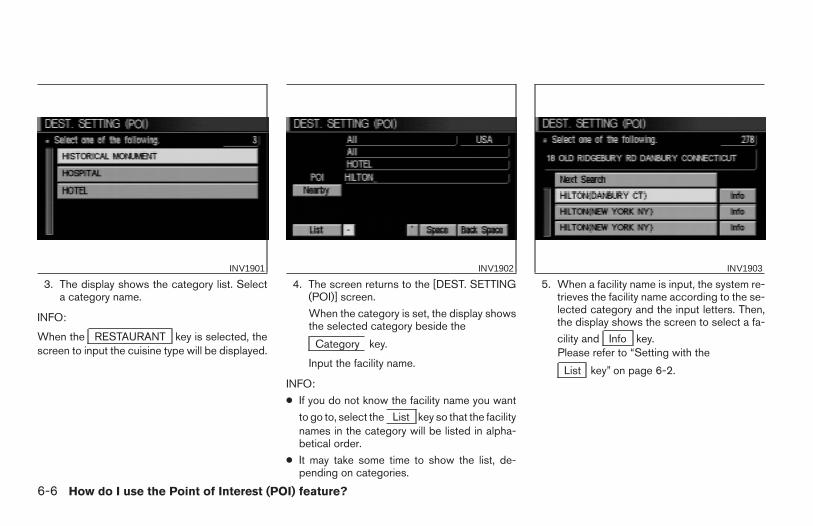
3. The display shows the category list. Selecta category name.
INFO:
When the RESTAURANT key is selected, thescreen to input the cuisine type will be displayed.
4. The screen returns to the [DEST. SETTING(POI)] screen.
When the category is set, the display showsthe selected category beside the
Category key.
Input the facility name.
INFO:
● If you do not know the facility name you want
to go to, select the List key so that the facilitynames in the category will be listed in alpha-betical order.
● It may take some time to show the list, de-pending on categories.
5. When a facility name is input, the system re-trieves the facility name according to the se-lected category and the input letters. Then,the display shows the screen to select a fa-
cility and Info key.Please refer to “Setting with the
List key” on page 6-2.
INV1901 INV1902 INV1903
6-6 How do I use the Point of Interest (POI) feature?
Z REVIEW COPY—2004 Maxima (max)Navigation System OM (navi)—USA_English (nna)04/27/04—tbrooks X
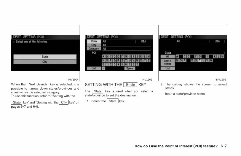
When the Next Search key is selected, it ispossible to narrow down states/provinces andcities within the selected category.To use this function, refer to “Setting with the
State key”and “Setting with the City key”onpages 6-7 and 6-9.
SETTING WITH THE State KEY
The State key is used when you select astate/province to set the destination.
1. Select the State key.
2. The display shows the screen to selectstates.
Input a state/province name.
INV1904 INV1905 INV1906
How do I use the Point of Interest (POI) feature? 6-7
Z REVIEW COPY—2004 Maxima (max)Navigation System OM (navi)—USA_English (nna)04/27/04—tbrooks X
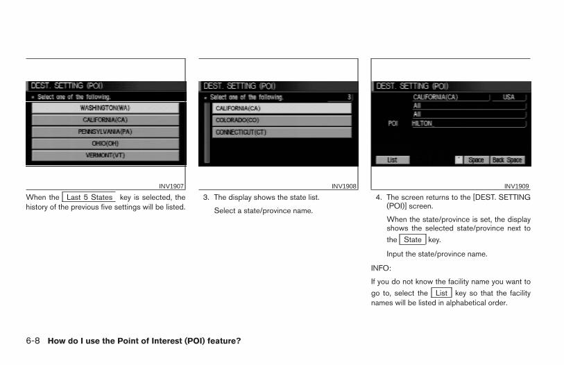
When the Last 5 States key is selected, thehistory of the previous five settings will be listed.
3. The display shows the state list.
Select a state/province name.
4. The screen returns to the [DEST. SETTING(POI)] screen.
When the state/province is set, the displayshows the selected state/province next to
the State key.
Input the state/province name.
INFO:
If you do not know the facility name you want to
go to, select the List key so that the facilitynames will be listed in alphabetical order.
INV1907 INV1908 INV1909
6-8 How do I use the Point of Interest (POI) feature?
Z REVIEW COPY—2004 Maxima (max)Navigation System OM (navi)—USA_English (nna)04/27/04—tbrooks X
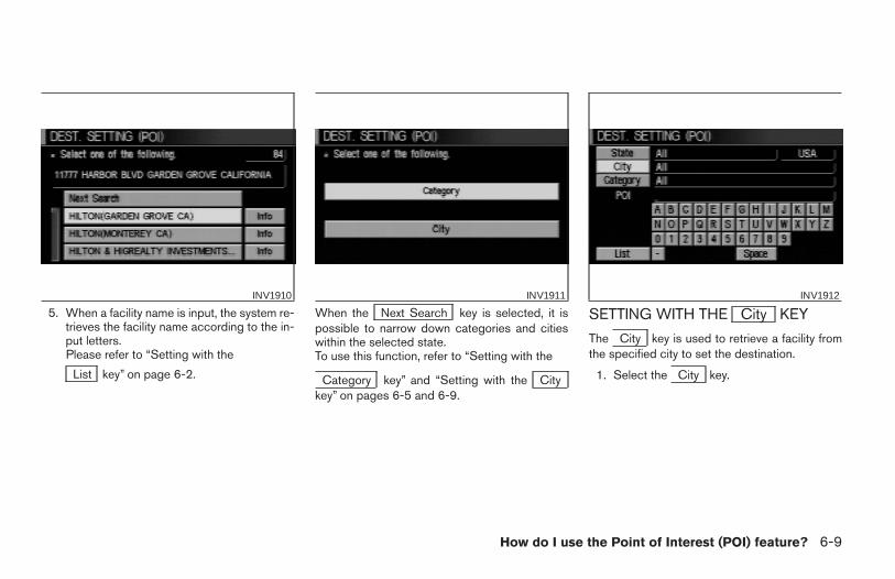
5. When a facility name is input, the system re-trieves the facility name according to the in-put letters.Please refer to “Setting with the
List key” on page 6-2.
When the Next Search key is selected, it ispossible to narrow down categories and citieswithin the selected state.To use this function, refer to “Setting with the
Category key” and “Setting with the Citykey” on pages 6-5 and 6-9.
SETTING WITH THE City KEY
The City key is used to retrieve a facility fromthe specified city to set the destination.
1. Select the City key.
INV1910 INV1911 INV1912
How do I use the Point of Interest (POI) feature? 6-9
Z REVIEW COPY—2004 Maxima (max)Navigation System OM (navi)—USA_English (nna)04/27/04—tbrooks X
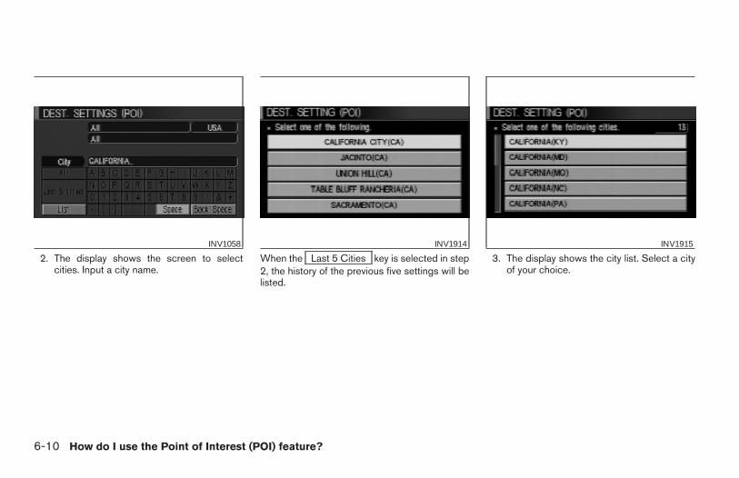
2. The display shows the screen to selectcities. Input a city name.
When the Last 5 Cities key is selected in step2, the history of the previous five settings will belisted.
3. The display shows the city list. Select a cityof your choice.
INV1058 INV1914 INV1915
6-10 How do I use the Point of Interest (POI) feature?
Z REVIEW COPY—2004 Maxima (max)Navigation System OM (navi)—USA_English (nna)04/27/04—tbrooks X
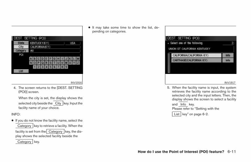
4. The screen returns to the [DEST. SETTING(POI)] screen.
When the city is set, the display shows the
selected city beside the City key. Input thefacility name of your choice.
INFO:
● If you do not know the facility name, select the
Category key to retrieve a facility. When the
facility is set from the Category key, the dis-play shows the selected facility beside the
Category key.
● It may take some time to show the list, de-pending on categories.
5. When the facility name is input, the systemretrieves the facility name according to theselected city and the input letters. Then, thedisplay shows the screen to select a facility
and Info key.Please refer to “Setting with the
List key” on page 6-2.
INV1916 INV1917
How do I use the Point of Interest (POI) feature? 6-11
Z REVIEW COPY—2004 Maxima (max)Navigation System OM (navi)—USA_English (nna)04/27/04—tbrooks X
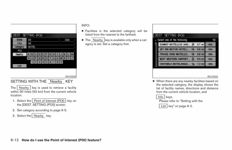
SETTING WITH THE Nearby KEY
The Nearby key is used to retrieve a facilitywithin 30 miles (50 km) from the current vehiclelocation.
1. Select the Point of Interest (POI) key onthe [DEST. SETTING (POI)] screen.
2. Set category according to page 6-5.
3. Select the Nearby key.
INFO:
● Facilities in the selected category will belisted from the nearest to the farthest.
● The Nearby key is available only when a cat-egory is set. Set a category first.
● When there are any nearby facilities based onthe selected category, the display shows thelist of facility names, directions and distancefrom the current vehicle location, and
Info keys.Please refer to “Setting with the
List key” on page 6-2.
INV1918 INV1919
6-12 How do I use the Point of Interest (POI) feature?
Z REVIEW COPY—2004 Maxima (max)Navigation System OM (navi)—USA_English (nna)04/27/04—tbrooks X
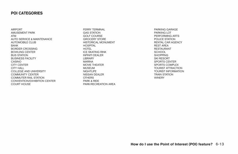
AIRPORT FERRY TERMINAL PARKING GARAGEAMUSEMENT PARK GAS STATION PARKING LOTATM GOLF COURSE PERFORMING ARTSAUTO SERVICE & MAINTENANCE GROCERY STORE POLICE STATIONAUTOMOBILE CLUB HISTORICAL MONUMENT RENTAL CAR AGENCYBANK HOSPITAL REST AREABORDER CROSSING HOTEL RESTAURANTBOWLING CENTER ICE SKATING RINK SCHOOLBUS STATION INFINITI DEALER SHOPPINGBUSINESS FACILITY LIBRARY SKI RESORTCASINO MARINA SPORTS CENTERCITY CENTER MOVIE THEATER SPORTS COMPLEXCITY HALL MUSEUM TOURIST ATTRACTIONCOLLEGE AND UNIVERSITY NIGHTLIFE TOURIST INFORMATIONCOMMUNITY CENTER NISSAN DEALER TRAIN STATIONCOMMUTER RAIL STATION OTHERS WINERYCONVENTION/EXHIBITION CENTER PARK & RIDECOURT HOUSE PARK/RECREATION AREA
POI CATEGORIES
How do I use the Point of Interest (POI) feature? 6-13
Z REVIEW COPY—2004 Maxima (max)Navigation System OM (navi)—USA_English (nna)04/27/04—tbrooks X
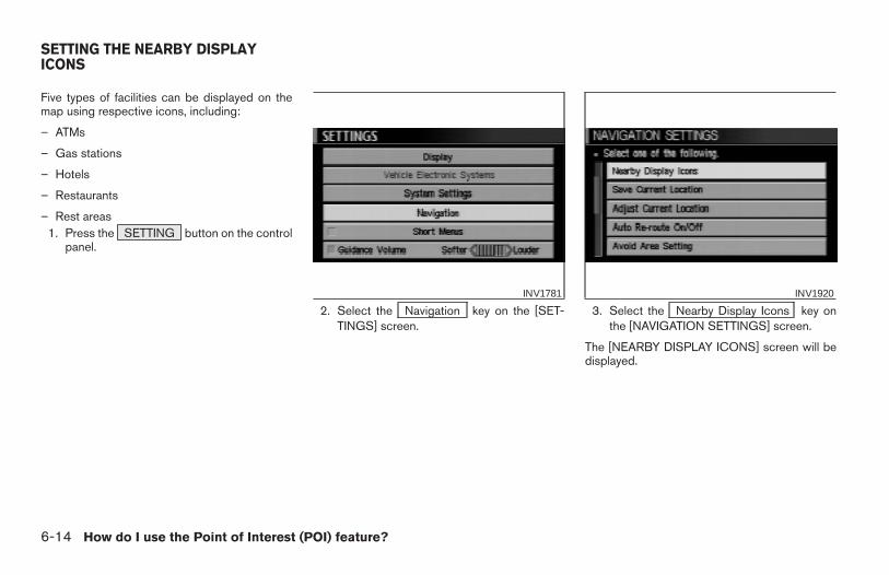
Five types of facilities can be displayed on themap using respective icons, including:
– ATMs
– Gas stations
– Hotels
– Restaurants
– Rest areas1. Press the SETTING button on the control
panel.
2. Select the Navigation key on the [SET-TINGS] screen.
3. Select the Nearby Display Icons key onthe [NAVIGATION SETTINGS] screen.
The [NEARBY DISPLAY ICONS] screen will bedisplayed.
INV1781 INV1920
SETTING THE NEARBY DISPLAYICONS
6-14 How do I use the Point of Interest (POI) feature?
Z REVIEW COPY—2004 Maxima (max)Navigation System OM (navi)—USA_English (nna)04/27/04—tbrooks X
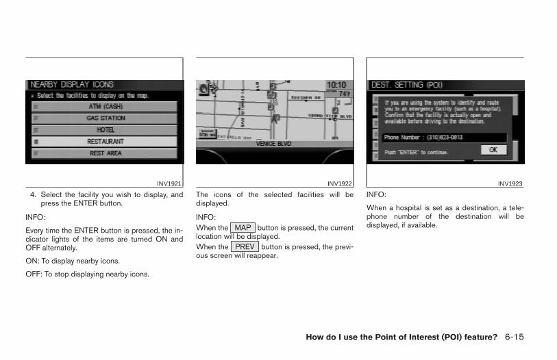
4. Select the facility you wish to display, andpress the ENTER button.
INFO:
Every time the ENTER button is pressed, the in-dicator lights of the items are turned ON andOFF alternately.
ON: To display nearby icons.
OFF: To stop displaying nearby icons.
The icons of the selected facilities will bedisplayed.
INFO:When the MAP button is pressed, the currentlocation will be displayed.When the PREV button is pressed, the previ-ous screen will reappear.
INFO:
When a hospital is set as a destination, a tele-phone number of the destination will bedisplayed, if available.
INV1921 INV1922 INV1923
How do I use the Point of Interest (POI) feature? 6-15
Z REVIEW COPY—2004 Maxima (max)Navigation System OM (navi)—USA_English (nna)04/27/04—tbrooks X

6-16 How do I use the Point of Interest (POI) feature?
MEMO
7 How do I use the address book feature?
Setting up and editing the address book . . . . . . . . . . . . . 7-2Setting up the address book . . . . . . . . . . . . . . . . . . . . . . . . 7-2
Using various categories to store locations . . . . . . . . 7-2Storing current vehicle position . . . . . . . . . . . . . . . . . . 7-4Storing locations of your choice . . . . . . . . . . . . . . . . . . 7-5Confirming the stored locations . . . . . . . . . . . . . . . . . . 7-5
Changing the listing order . . . . . . . . . . . . . . . . . . . . . . . 7-7Editing the address book . . . . . . . . . . . . . . . . . . . . . . . . . . . 7-8
Changing stored names . . . . . . . . . . . . . . . . . . . . . . . . . 7-8Changing the icons . . . . . . . . . . . . . . . . . . . . . . . . . . . . . 7-9Adjusting the stored address book entries . . . . . . . . 7-13Deleting stored locations . . . . . . . . . . . . . . . . . . . . . . . 7-15
Z REVIEW COPY—2004 Maxima (max)Navigation System OM (navi)—USA_English (nna)04/27/04—tbrooks X
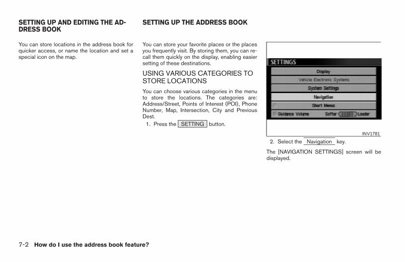
You can store locations in the address book forquicker access, or name the location and set aspecial icon on the map.
You can store your favorite places or the placesyou frequently visit. By storing them, you can re-call them quickly on the display, enabling easiersetting of these destinations.
USING VARIOUS CATEGORIES TOSTORE LOCATIONSYou can choose various categories in the menuto store the locations. The categories are:Address/Street, Points of Interest (POI), PhoneNumber, Map, Intersection, City and PreviousDest.
1. Press the SETTING button.
2. Select the Navigation key.
The [NAVIGATION SETTINGS] screen will bedisplayed.
INV1781
SETTING UP AND EDITING THE AD-DRESS BOOK
SETTING UP THE ADDRESS BOOK
7-2 How do I use the address book feature?
Z REVIEW COPY—2004 Maxima (max)Navigation System OM (navi)—USA_English (nna)04/27/04—tbrooks X
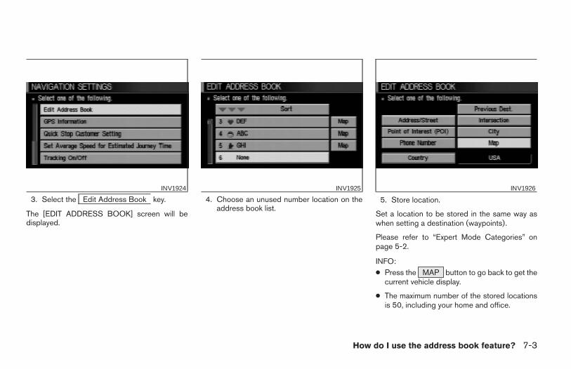
3. Select the Edit Address Book key.
The [EDIT ADDRESS BOOK] screen will bedisplayed.
4. Choose an unused number location on theaddress book list.
5. Store location.
Set a location to be stored in the same way aswhen setting a destination (waypoints).
Please refer to “Expert Mode Categories” onpage 5-2.
INFO:● Press the MAP button to go back to get the
current vehicle display.
● The maximum number of the stored locationsis 50, including your home and office.
INV1924 INV1925 INV1926
How do I use the address book feature? 7-3
Z REVIEW COPY—2004 Maxima (max)Navigation System OM (navi)—USA_English (nna)04/27/04—tbrooks X
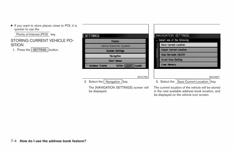
● If you want to store places close to POI, it isquicker to use the
Points of Interest (POI) key.
STORING CURRENT VEHICLE PO-SITION
1. Press the SETTING button.
2. Select the Navigation key.
The [NAVIGATION SETTINGS] screen willbe displayed.
3. Select the Save Current Location key.
The current location of the vehicle will be storedin the next available address book location, andbe displayed on the vehicle icon screen.
INV1781 INV1927
7-4 How do I use the address book feature?
Z REVIEW COPY—2004 Maxima (max)Navigation System OM (navi)—USA_English (nna)04/27/04—tbrooks X
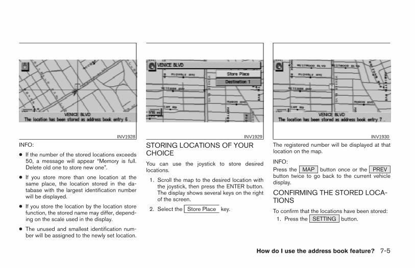
INFO:
● If the number of the stored locations exceeds50, a message will appear “Memory is full.Delete old one to store new one”.
● If you store more than one location at thesame place, the location stored in the da-tabase with the largest identification numberwill be displayed.
● If you store the location by the location storefunction, the stored name may differ, depend-ing on the scale used in the display.
● The unused and smallest identification num-ber will be assigned to the newly set location.
STORING LOCATIONS OF YOURCHOICEYou can use the joystick to store desiredlocations.
1. Scroll the map to the desired location withthe joystick, then press the ENTER button.The display shows several keys on the rightof the screen.
2. Select the Store Place key.
The registered number will be displayed at thatlocation on the map.
INFO:Press the MAP button once or the PREVbutton twice to go back to the current vehicledisplay.
CONFIRMING THE STORED LOCA-TIONSTo confirm that the locations have been stored:
1. Press the SETTING button.
INV1928 INV1929 INV1930
How do I use the address book feature? 7-5
Z REVIEW COPY—2004 Maxima (max)Navigation System OM (navi)—USA_English (nna)04/27/04—tbrooks X
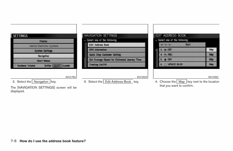
2. Select the Navigation key.
The [NAVIGATION SETTINGS] screen will bedisplayed.
3. Select the Edit Address Book key. 4. Choose the Map key next to the locationthat you want to confirm.
INV1781 INV1924 INV1931
7-6 How do I use the address book feature?
Z REVIEW COPY—2004 Maxima (max)Navigation System OM (navi)—USA_English (nna)04/27/04—tbrooks X
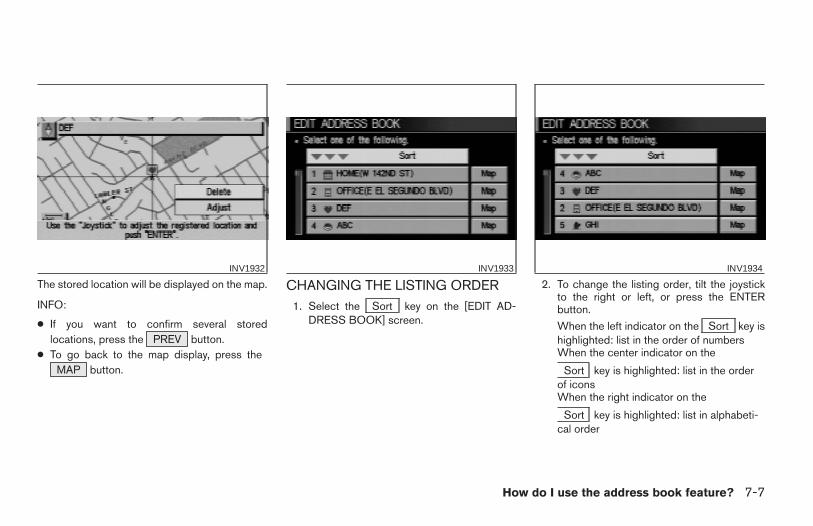
The stored location will be displayed on the map.
INFO:
● If you want to confirm several storedlocations, press the PREV button.
● To go back to the map display, press theMAP button.
CHANGING THE LISTING ORDER1. Select the Sort key on the [EDIT AD-
DRESS BOOK] screen.
2. To change the listing order, tilt the joystickto the right or left, or press the ENTERbutton.
When the left indicator on the Sort key ishighlighted: list in the order of numbersWhen the center indicator on the
Sort key is highlighted: list in the orderof iconsWhen the right indicator on the
Sort key is highlighted: list in alphabeti-cal order
INV1932 INV1933 INV1934
How do I use the address book feature? 7-7
Z REVIEW COPY—2004 Maxima (max)Navigation System OM (navi)—USA_English (nna)04/27/04—tbrooks X

You can alter the names or the icons of thestored locations.
CHANGING STORED NAMES1. Press the SETTING button.
2. Select the Navigation key. 3. Select the Edit Address Book key.INV1781 INV1924
EDITING THE ADDRESS BOOK
7-8 How do I use the address book feature?
Z REVIEW COPY—2004 Maxima (max)Navigation System OM (navi)—USA_English (nna)04/27/04—tbrooks X

4. Choose the stored location you want tochange the name of.
5. Select the Rename key.
The change name screen will be displayed.
6. Select the Set key after entering the newname.
INFO:To go back to the map display, press the
MAP button.
CHANGING THE ICONS1. You can display the icon at a stored
location.Press the SETTING button.
INV1935 INV1936 INV1937
How do I use the address book feature? 7-9
Z REVIEW COPY—2004 Maxima (max)Navigation System OM (navi)—USA_English (nna)04/27/04—tbrooks X

2. Select the Navigation key.
The [NAVIGATION SETTINGS] screen will bedisplayed.
3. Select the Edit Address Book key. 4. Choose a stored location where you want toset the icon.
INV1781 INV1924 INV1938
7-10 How do I use the address book feature?
Z REVIEW COPY—2004 Maxima (max)Navigation System OM (navi)—USA_English (nna)04/27/04—tbrooks X
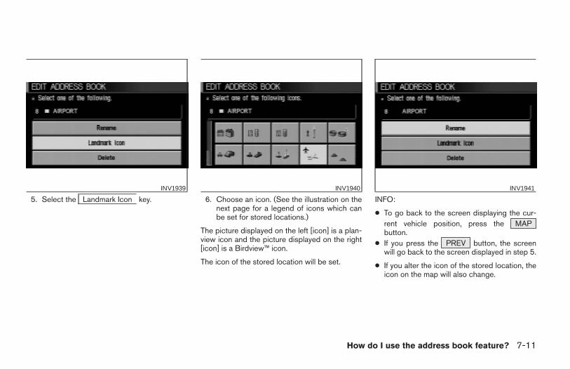
5. Select the Landmark Icon key. 6. Choose an icon. (See the illustration on thenext page for a legend of icons which canbe set for stored locations.)
The picture displayed on the left [icon] is a plan-view icon and the picture displayed on the right[icon] is a Birdview™ icon.
The icon of the stored location will be set.
INFO:
● To go back to the screen displaying the cur-rent vehicle position, press the MAPbutton.
● If you press the PREV button, the screenwill go back to the screen displayed in step 5.
● If you alter the icon of the stored location, theicon on the map will also change.
INV1939 INV1940 INV1941
How do I use the address book feature? 7-11
Z REVIEW COPY—2004 Maxima (max)Navigation System OM (navi)—USA_English (nna)04/27/04—tbrooks X
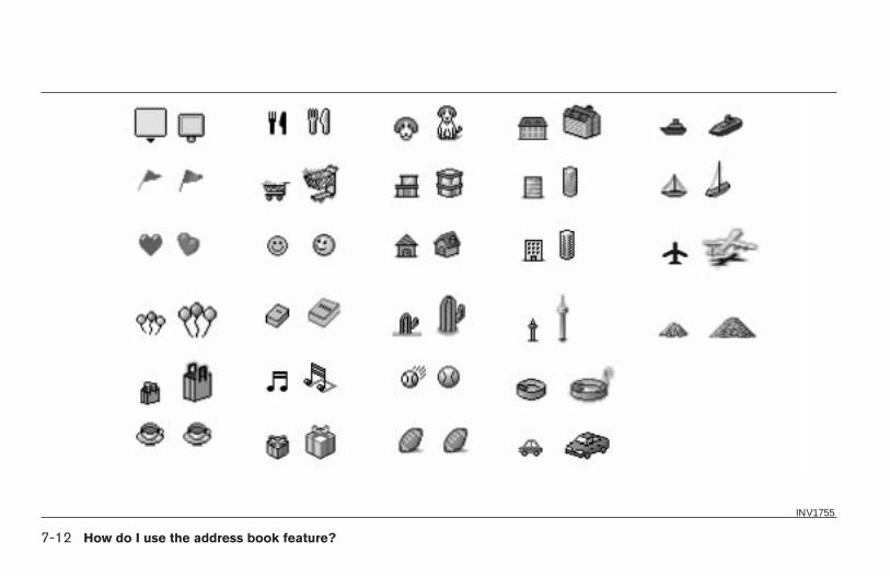
INV1755
7-12 How do I use the address book feature?
Z REVIEW COPY—2004 Maxima (max)Navigation System OM (navi)—USA_English (nna)04/27/04—tbrooks X
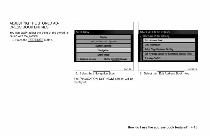
ADJUSTING THE STORED AD-DRESS BOOK ENTRIESYou can easily adjust the point of the stored lo-cation with the joystick.
1. Press the SETTING button.
2. Select the Navigation key.
The [NAVIGATION SETTINGS] screen will bedisplayed.
3. Select the Edit Address Book key.INV1781 INV1924
How do I use the address book feature? 7-13
Z REVIEW COPY—2004 Maxima (max)Navigation System OM (navi)—USA_English (nna)04/27/04—tbrooks X
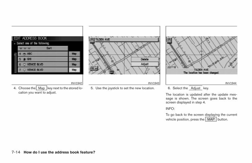
4. Choose the Map key next to the stored lo-cation you want to adjust.
5. Use the joystick to set the new location. 6. Select the Adjust key.
The location is updated after the update mes-sage is shown. The screen goes back to thescreen displayed in step 4.
INFO:
To go back to the screen displaying the currentvehicle position, press the MAP button.
INV1942 INV1943 INV1944
7-14 How do I use the address book feature?
Z REVIEW COPY—2004 Maxima (max)Navigation System OM (navi)—USA_English (nna)04/27/04—tbrooks X
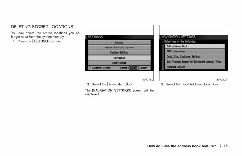
DELETING STORED LOCATIONSYou can delete the stored locations you nolonger need from the system memory.
1. Press the SETTING button.
2. Select the Navigation key.
The [NAVIGATION SETTINGS] screen will bedisplayed.
3. Select the Edit Address Book key.INV1781 INV1924
How do I use the address book feature? 7-15
Z REVIEW COPY—2004 Maxima (max)Navigation System OM (navi)—USA_English (nna)04/27/04—tbrooks X
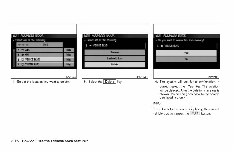
4. Select the location you want to delete. 5. Select the Delete key. 6. The system will ask for a confirmation. If
correct, select the Yes key. The locationwill be deleted. After the deletion message isshown, the screen goes back to the screendisplayed in step 4.
INFO:
To go back to the screen displaying the currentvehicle position, press the MAP button.
INV1945 INV1946 INV1947
7-16 How do I use the address book feature?
Z REVIEW COPY—2004 Maxima (max)Navigation System OM (navi)—USA_English (nna)04/27/04—tbrooks X
8 How do I use the avoid area feature?
Setting avoid areas . . . . . . . . . . . . . . . . . . . . . . . . . . . . . . . . 8-2Setting with the selected location key . . . . . . . . . . . . . . . . 8-5
Renaming the avoid areas . . . . . . . . . . . . . . . . . . . . . . . 8-5
Deleting the avoid areas. . . . . . . . . . . . . . . . . . . . . . . . . 8-7
Setting with the Map key. . . . . . . . . . . . . . . . . . . . . . 8-8
Z REVIEW COPY—2004 Maxima (max)Navigation System OM (navi)—USA_English (nna)04/27/04—tbrooks X
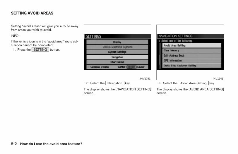
Setting “avoid areas” will give you a route awayfrom areas you wish to avoid.
INFO:
If the vehicle icon is in the “avoid area,” route cal-culation cannot be completed.
1. Press the SETTING button.
2. Select the Navigation key.
The display shows the [NAVIGATION SETTING]screen.
3. Select the Avoid Area Setting key.
The display shows the [AVOID AREA SETTING]screen.
INV1781 INV1948
SETTING AVOID AREAS
8-2 How do I use the avoid area feature?
Z REVIEW COPY—2004 Maxima (max)Navigation System OM (navi)—USA_English (nna)04/27/04—tbrooks X
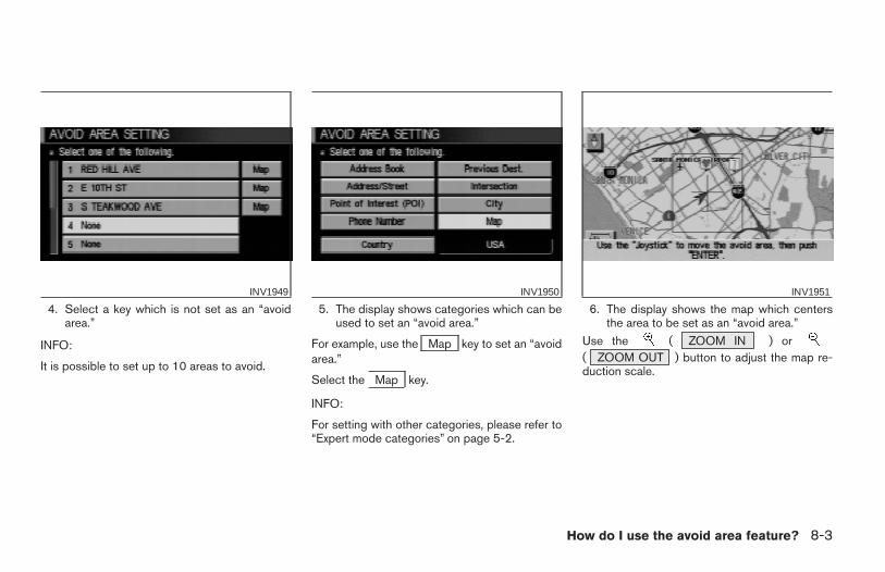
4. Select a key which is not set as an “avoidarea.”
INFO:
It is possible to set up to 10 areas to avoid.
5. The display shows categories which can beused to set an “avoid area.”
For example, use the Map key to set an “avoidarea.”
Select the Map key.
INFO:
For setting with other categories, please refer to“Expert mode categories” on page 5-2.
6. The display shows the map which centersthe area to be set as an “avoid area.”
Use the ( ZOOM IN ) or( ZOOM OUT ) button to adjust the map re-duction scale.
INV1949 INV1950 INV1951
How do I use the avoid area feature? 8-3
Z REVIEW COPY—2004 Maxima (max)Navigation System OM (navi)—USA_English (nna)04/27/04—tbrooks X
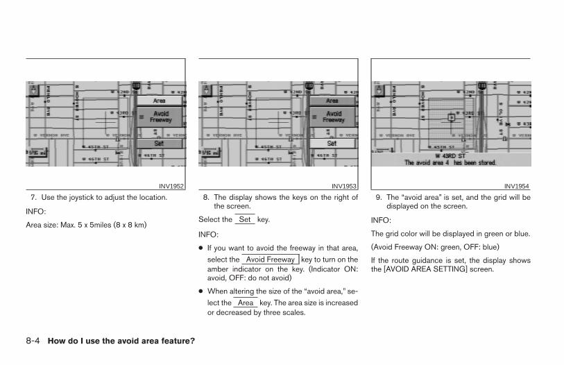
7. Use the joystick to adjust the location.
INFO:
Area size: Max. 5 x 5miles (8 x 8 km)
8. The display shows the keys on the right ofthe screen.
Select the Set key.
INFO:
● If you want to avoid the freeway in that area,
select the Avoid Freeway key to turn on theamber indicator on the key. (Indicator ON:avoid, OFF: do not avoid)
● When altering the size of the “avoid area,” se-
lect the Area key. The area size is increasedor decreased by three scales.
9. The “avoid area” is set, and the grid will bedisplayed on the screen.
INFO:
The grid color will be displayed in green or blue.
(Avoid Freeway ON: green, OFF: blue)
If the route guidance is set, the display showsthe [AVOID AREA SETTING] screen.
INV1952 INV1953 INV1954
8-4 How do I use the avoid area feature?
Z REVIEW COPY—2004 Maxima (max)Navigation System OM (navi)—USA_English (nna)04/27/04—tbrooks X
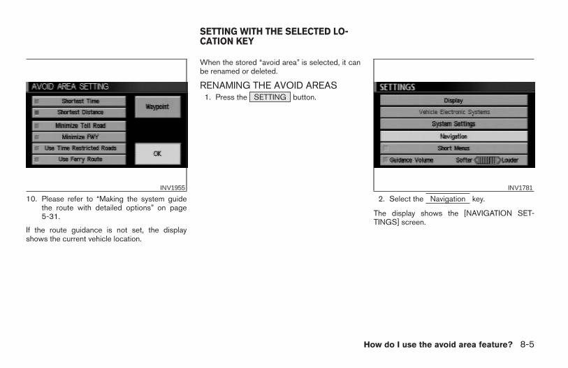
10. Please refer to “Making the system guidethe route with detailed options” on page5-31.
If the route guidance is not set, the displayshows the current vehicle location.
When the stored “avoid area” is selected, it canbe renamed or deleted.
RENAMING THE AVOID AREAS1. Press the SETTING button.
2. Select the Navigation key.
The display shows the [NAVIGATION SET-TINGS] screen.
INV1955 INV1781
SETTING WITH THE SELECTED LO-CATION KEY
How do I use the avoid area feature? 8-5
Z REVIEW COPY—2004 Maxima (max)Navigation System OM (navi)—USA_English (nna)04/27/04—tbrooks X
3. Select the Avoid Area Setting key.
The display shows the [AVOID AREA SETTING]screen.
4. Select a key which is set as an “avoid area.” 5. Select the Rename key.INV1948 INV1956 INV1957
8-6 How do I use the avoid area feature?
Z REVIEW COPY—2004 Maxima (max)Navigation System OM (navi)—USA_English (nna)04/27/04—tbrooks X
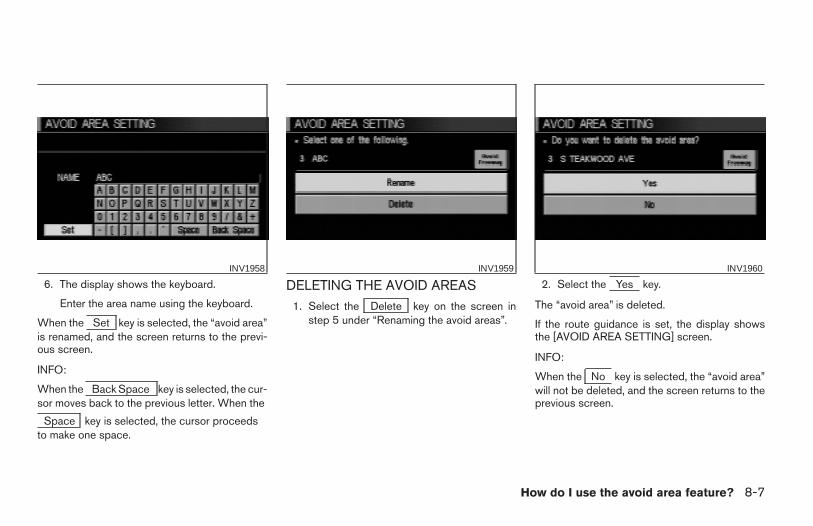
6. The display shows the keyboard.
Enter the area name using the keyboard.
When the Set key is selected, the “avoid area”is renamed, and the screen returns to the previ-ous screen.
INFO:
When the Back Space key is selected, the cur-sor moves back to the previous letter. When the
Space key is selected, the cursor proceedsto make one space.
DELETING THE AVOID AREAS1. Select the Delete key on the screen in
step 5 under “Renaming the avoid areas”.
2. Select the Yes key.
The “avoid area” is deleted.
If the route guidance is set, the display showsthe [AVOID AREA SETTING] screen.
INFO:
When the No key is selected, the “avoid area”will not be deleted, and the screen returns to theprevious screen.
INV1958 INV1959 INV1960
How do I use the avoid area feature? 8-7
Z REVIEW COPY—2004 Maxima (max)Navigation System OM (navi)—USA_English (nna)04/27/04—tbrooks X
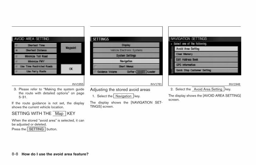
3. Please refer to “Making the system guidethe route with detailed options” on page5-31.
If the route guidance is not set, the displayshows the current vehicle location.
SETTING WITH THE Map KEY
When the stored “avoid area” is selected, it canbe adjusted or deleted.Press the SETTING button.
Adjusting the stored avoid areas1. Select the Navigation key.
The display shows the [NAVIGATION SET-TINGS] screen.
2. Select the Avoid Area Setting key.
The display shows the [AVOID AREA SETTING]screen.
INV1955 INV1781 INV1948
8-8 How do I use the avoid area feature?
Z REVIEW COPY—2004 Maxima (max)Navigation System OM (navi)—USA_English (nna)04/27/04—tbrooks X
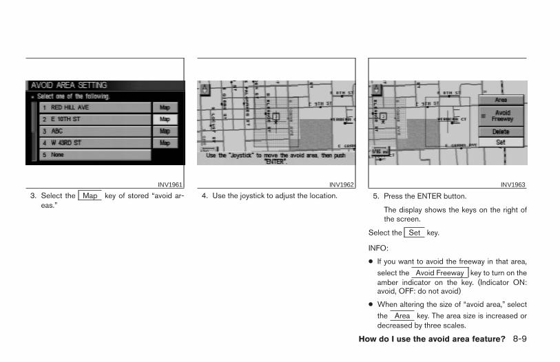
3. Select the Map key of stored “avoid ar-eas.”
4. Use the joystick to adjust the location. 5. Press the ENTER button.
The display shows the keys on the right ofthe screen.
Select the Set key.
INFO:
● If you want to avoid the freeway in that area,
select the Avoid Freeway key to turn on theamber indicator on the key. (Indicator ON:avoid, OFF: do not avoid)
● When altering the size of “avoid area,” select
the Area key. The area size is increased ordecreased by three scales.
INV1961 INV1962 INV1963
How do I use the avoid area feature? 8-9
Z REVIEW COPY—2004 Maxima (max)Navigation System OM (navi)—USA_English (nna)04/27/04—tbrooks X
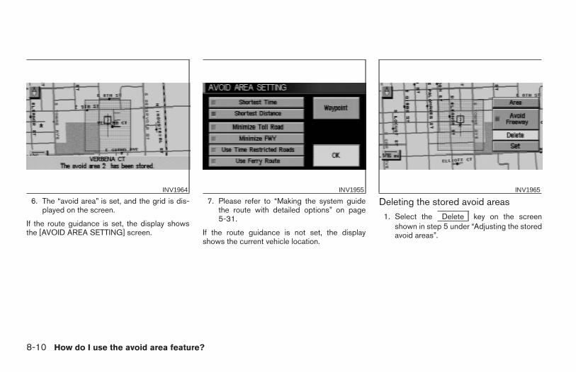
6. The “avoid area” is set, and the grid is dis-played on the screen.
If the route guidance is set, the display showsthe [AVOID AREA SETTING] screen.
7. Please refer to “Making the system guidethe route with detailed options” on page5-31.
If the route guidance is not set, the displayshows the current vehicle location.
Deleting the stored avoid areas1. Select the Delete key on the screen
shown in step 5 under “Adjusting the storedavoid areas”.
INV1964 INV1955 INV1965
8-10 How do I use the avoid area feature?
Z REVIEW COPY—2004 Maxima (max)Navigation System OM (navi)—USA_English (nna)04/27/04—tbrooks X
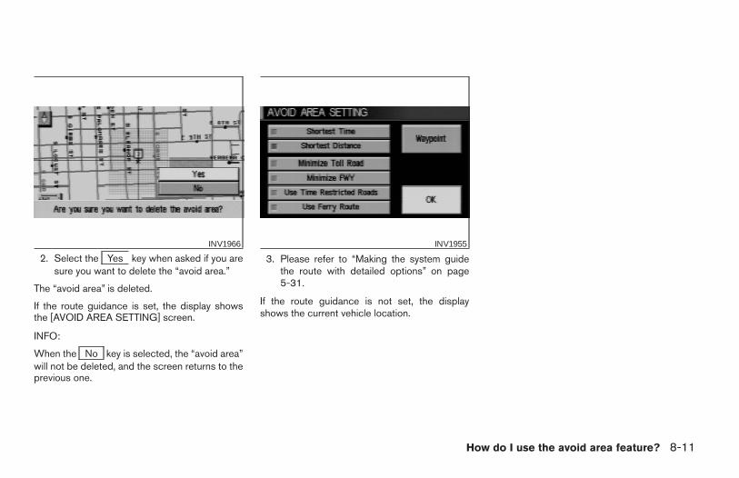
2. Select the Yes key when asked if you aresure you want to delete the “avoid area.”
The “avoid area” is deleted.
If the route guidance is set, the display showsthe [AVOID AREA SETTING] screen.
INFO:
When the No key is selected, the “avoid area”will not be deleted, and the screen returns to theprevious one.
3. Please refer to “Making the system guidethe route with detailed options” on page5-31.
If the route guidance is not set, the displayshows the current vehicle location.
INV1966 INV1955
How do I use the avoid area feature? 8-11
Z REVIEW COPY—2004 Maxima (max)Navigation System OM (navi)—USA_English (nna)04/27/04—tbrooks X

8-12 How do I use the avoid area feature?
MEMO
9 How do I use the automatic re-routingfeature?
Re-routing when the vehicle is off the suggestedroute . . . . . . . . . . . . . . . . . . . . . . . . . . . . . . . . . . . . . . . . . . . . . 9-2
Automatic re-routing . . . . . . . . . . . . . . . . . . . . . . . . . . . . 9-2
Detouring from the route temporarily . . . . . . . . . . . . . . . . . 9-3
Z REVIEW COPY—2004 Maxima (max)Navigation System OM (navi)—USA_English (nna)04/27/04—tbrooks X
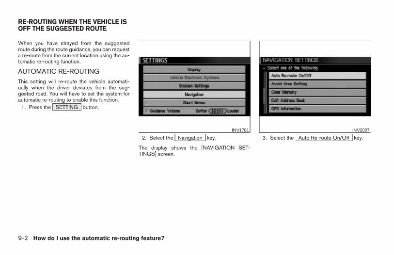
When you have strayed from the suggestedroute during the route guidance, you can requesta re-route from the current location using the au-tomatic re-routing function.
AUTOMATIC RE-ROUTINGThis setting will re-route the vehicle automati-cally when the driver deviates from the sug-gested road. You will have to set the system forautomatic re-routing to enable this function.
1. Press the SETTING button.
2. Select the Navigation key.
The display shows the [NAVIGATION SET-TINGS] screen.
3. Select the Auto Re-route On/Off key.INV1781 INV2007
RE-ROUTING WHEN THE VEHICLE ISOFF THE SUGGESTED ROUTE
9-2 How do I use the automatic re-routing feature?
Z REVIEW COPY—2004 Maxima (max)Navigation System OM (navi)—USA_English (nna)04/27/04—tbrooks X
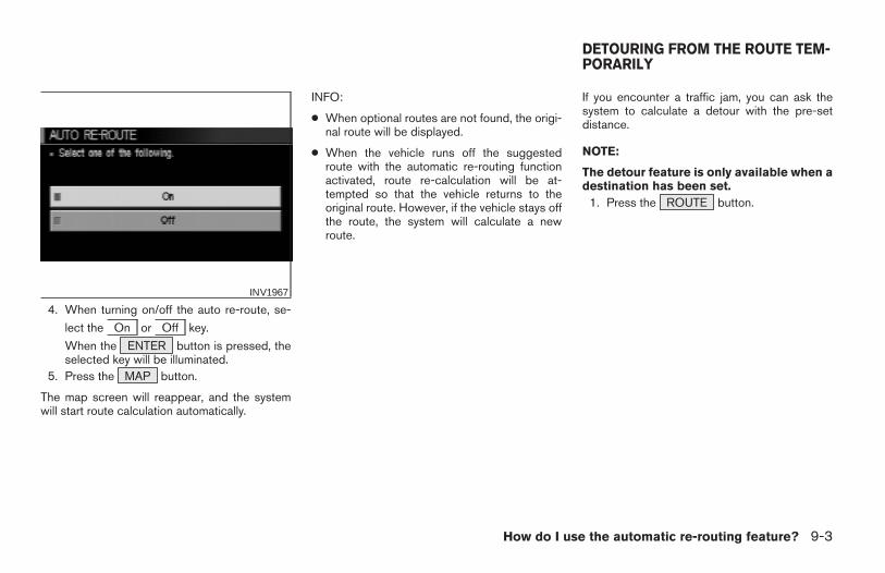
4. When turning on/off the auto re-route, se-
lect the On or Off key.
When the ENTER button is pressed, theselected key will be illuminated.
5. Press the MAP button.
The map screen will reappear, and the systemwill start route calculation automatically.
INFO:
● When optional routes are not found, the origi-nal route will be displayed.
● When the vehicle runs off the suggestedroute with the automatic re-routing functionactivated, route re-calculation will be at-tempted so that the vehicle returns to theoriginal route. However, if the vehicle stays offthe route, the system will calculate a newroute.
If you encounter a traffic jam, you can ask thesystem to calculate a detour with the pre-setdistance.
NOTE:
The detour feature is only available when adestination has been set.
1. Press the ROUTE button.
INV1967
DETOURING FROM THE ROUTE TEM-PORARILY
How do I use the automatic re-routing feature? 9-3
Z REVIEW COPY—2004 Maxima (max)Navigation System OM (navi)—USA_English (nna)04/27/04—tbrooks X
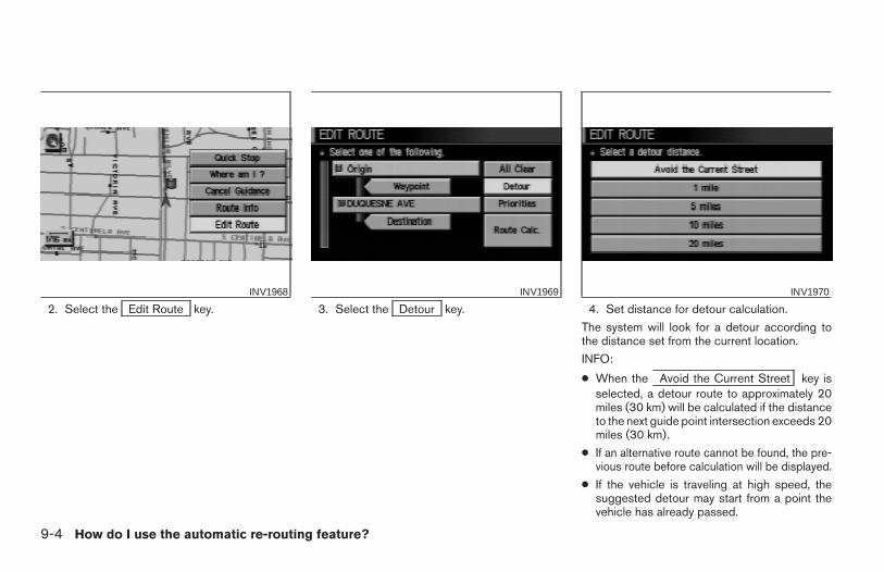
2. Select the Edit Route key. 3. Select the Detour key. 4. Set distance for detour calculation.
The system will look for a detour according tothe distance set from the current location.
INFO:
● When the Avoid the Current Street key isselected, a detour route to approximately 20miles (30 km) will be calculated if the distanceto the next guide point intersection exceeds 20miles (30 km).
● If an alternative route cannot be found, the pre-vious route before calculation will be displayed.
● If the vehicle is traveling at high speed, thesuggested detour may start from a point thevehicle has already passed.
INV1968 INV1969 INV1970
9-4 How do I use the automatic re-routing feature?
Z REVIEW COPY—2004 Maxima (max)Navigation System OM (navi)—USA_English (nna)04/27/04—tbrooks X
10 How do I use the voice guidance fea-ture?
About voice guidance . . . . . . . . . . . . . . . . . . . . . . . . . . . . .10-2Basics of voice guidance . . . . . . . . . . . . . . . . . . . . . . . 10-2Adjusting the guide volume . . . . . . . . . . . . . . . . . . . . . 10-2Directions given and the distance to the roadpoints . . . . . . . . . . . . . . . . . . . . . . . . . . . . . . . . . . . . . . . .10-3Notification of an intersection on an ordinaryroad . . . . . . . . . . . . . . . . . . . . . . . . . . . . . . . . . . . . . . . . .10-3
Notification of consecutive intersections onan ordinary road . . . . . . . . . . . . . . . . . . . . . . . . . . . . . . .10-3Notification of an entrance to a freeway . . . . . . . . . . 10-3Notification of a freeway junction . . . . . . . . . . . . . . . . 10-3Notification of an exit from a freeway . . . . . . . . . . . . . 10-3
Requesting current voice information . . . . . . . . . . . . . . . 10-3Notes on the voice guidance. . . . . . . . . . . . . . . . . . . . . . . 10-4
Z REVIEW COPY—2004 Maxima (max)Navigation System OM (navi)—USA_English (nna)04/27/04—tbrooks X
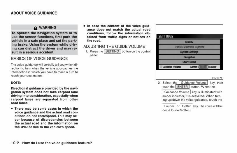
WARNING
To operate the navigation system or touse the screen functions, first park thevehicle in a safe place and set the park-ing brake. Using the system while driv-ing can distract the driver and may re-sult in a serious accident.
BASICS OF VOICE GUIDANCEThe voice guidance will verbally tell you which di-rection to turn when the vehicle approaches theintersection in which you have to make a turn toreach your destination.
NOTE:
Directional guidance provided by the navi-gation system does not take carpool lanedriving into consideration, especially whencarpool lanes are separated from otherroad lanes.
● There may be some cases in which thevoice guidance and the actual road con-ditions do not correspond. This may oc-cur because of discrepancies betweenthe actual road and the information onthe DVD or due to the vehicle’s speed.
● In case the content of the voice guid-ance does not match the actual roadconditions, follow the information ob-tained from traffic signs or notices onthe road.
ADJUSTING THE GUIDE VOLUME1. Press the SETTING button on the control
panel.
2. Select the Guidance Volume key, thenpush the ENTER button. When the
Guidance Volume key is illuminated withamber indicator, it is activated. When turn-ing up/down the voice guidance, touch the
Louder or Softer key. The voice will be-come louder/softer.
INV1971
ABOUT VOICE GUIDANCE
10-2 How do I use the voice guidance feature?
Z REVIEW COPY—2004 Maxima (max)Navigation System OM (navi)—USA_English (nna)04/27/04—tbrooks X
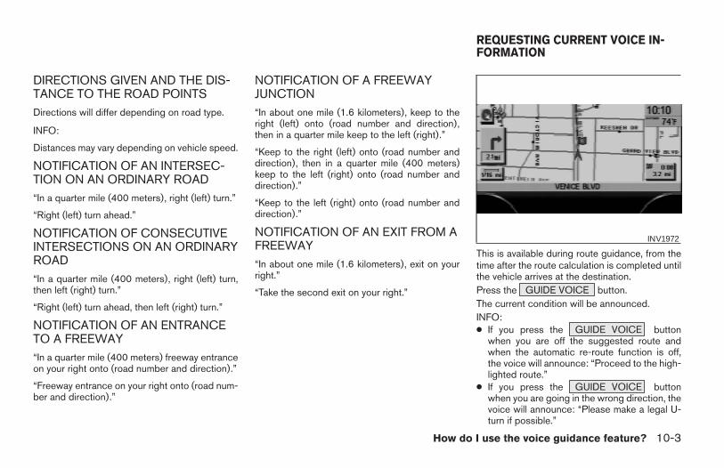
DIRECTIONS GIVEN AND THE DIS-TANCE TO THE ROAD POINTSDirections will differ depending on road type.
INFO:
Distances may vary depending on vehicle speed.
NOTIFICATION OF AN INTERSEC-TION ON AN ORDINARY ROAD“In a quarter mile (400 meters), right (left) turn.”
“Right (left) turn ahead.”
NOTIFICATION OF CONSECUTIVEINTERSECTIONS ON AN ORDINARYROAD“In a quarter mile (400 meters), right (left) turn,then left (right) turn.”
“Right (left) turn ahead, then left (right) turn.”
NOTIFICATION OF AN ENTRANCETO A FREEWAY“In a quarter mile (400 meters) freeway entranceon your right onto (road number and direction).”
“Freeway entrance on your right onto (road num-ber and direction).”
NOTIFICATION OF A FREEWAYJUNCTION“In about one mile (1.6 kilometers), keep to theright (left) onto (road number and direction),then in a quarter mile keep to the left (right).”
“Keep to the right (left) onto (road number anddirection), then in a quarter mile (400 meters)keep to the left (right) onto (road number anddirection).”
“Keep to the left (right) onto (road number anddirection).”
NOTIFICATION OF AN EXIT FROM AFREEWAY“In about one mile (1.6 kilometers), exit on yourright.”
“Take the second exit on your right.”
This is available during route guidance, from thetime after the route calculation is completed untilthe vehicle arrives at the destination.Press the GUIDE VOICE button.The current condition will be announced.INFO:● If you press the GUIDE VOICE button
when you are off the suggested route andwhen the automatic re-route function is off,the voice will announce: “Proceed to the high-lighted route.”
● If you press the GUIDE VOICE buttonwhen you are going in the wrong direction, thevoice will announce: “Please make a legal U-turn if possible.”
INV1972
REQUESTING CURRENT VOICE IN-FORMATION
How do I use the voice guidance feature? 10-3
Z REVIEW COPY—2004 Maxima (max)Navigation System OM (navi)—USA_English (nna)04/27/04—tbrooks X
● The voice guidance in this system should beregarded as a supplementary function. Whendriving your vehicle, check the route on themap display and follow the actual road and alltraffic regulations.
● The voice guidance is activated only for junc-tions with certain conditions. In some casesyou may need to turn, even if there is no voiceguidance.
● The content of the voice guidance may vary,depending on the direction of the turn and thetype of junction with other roads.
● The route guidance will be activated at vari-ous times depending on the situation.
● When the vehicle is off the suggested route,route guidance is not available. The systemwill not inform you of this; please refer to themap display and request rerouting.
● At freeway junctions, the road numbers anddirections may not accurately correspondwith the voice guidance.
● At freeway exits, the street names may not ac-curately correspond with the voice guidance.
● The displayed street names may sometimesdiffer from the actual names or “UNKNOWNSTREET NAME” may be displayed.
Please refer to “Automatic re-routing” on 9-2.
● When the amber indicator on the
Guide Volume key is not illuminated, thevoice guidance is not available.
● The voice guidance will start when the vehicleenters the suggested route. Before enteringthe route, refer to the map display for thedirection.
● When the vehicle approaches a waypoint, thevoice will say, “You have arrived at waypoint 1(2, 3, 4...).” The guidance will switch to thenext route section. While the voice guidanceis not available, please refer to the map dis-play for the direction.
● When the vehicle approaches a destination,the voice will say, “You have arrived at yourdestination. Ending route guidance.” For theremainder of the way, please find your direc-tion on the map display.
● In some cases, the voice guidance ends be-fore arrival at the destination. In such cases,drive the vehicle by referring to the destinationicon displayed on the map screen.
● When the system can judge on which side thedestination (waypoint) is located, the voiceguidance will say “on the right (left)” after an-nouncing the arrival at the destination.
● Voice guidance may not operate as specifiedor may not operate at all due to the angle ofroads at intersection entrances and exits.
NOTES ON THE VOICE GUIDANCE
10-4 How do I use the voice guidance feature?
Z REVIEW COPY—2004 Maxima (max)Navigation System OM (navi)—USA_English (nna)04/27/04—tbrooks X
11 How do I adjust the display?
Screen information — Plan View display. . . . . . . . . . . . . 11-2Screen information — Birdview™ display . . . . . . . . . . . . 11-2
Switching between Birdview™ and PlanView displays . . . . . . . . . . . . . . . . . . . . . . . . . . . . . . . . .11-3
Zooming in and out of the map . . . . . . . . . . . . . . . . . . . . . 11-6Changing the display direction(in Plan View display) . . . . . . . . . . . . . . . . . . . . . . . . . . . . .11-7Scrolling the map. . . . . . . . . . . . . . . . . . . . . . . . . . . . . . . . .11-9Displaying the complete route to the destination . . . .11-10Displaying turn list . . . . . . . . . . . . . . . . . . . . . . . . . . . . . . .11-11Requesting the simulation drive to the destination . . .11-13
Cancel simulation . . . . . . . . . . . . . . . . . . . . . . . . . . . .11-14
Displaying the track . . . . . . . . . . . . . . . . . . . . . . . . . . . . . .11-15GPS information display. . . . . . . . . . . . . . . . . . . . . . . . . .11-17Updating the current vehicle location and thedirection. . . . . . . . . . . . . . . . . . . . . . . . . . . . . . . . . . . . . . . .11-18Setting the display mode . . . . . . . . . . . . . . . . . . . . . . . . .11-20
Adjusting the display brightness. . . . . . . . . . . . . . . .11-20Adjusting the display contrast . . . . . . . . . . . . . . . . . .11-21Switching the display color . . . . . . . . . . . . . . . . . . . .11-22
How to handle the display . . . . . . . . . . . . . . . . . . . . . . . .11-24Characteristics of liquid crystal display . . . . . . . . . .11-24Maintenance of the display . . . . . . . . . . . . . . . . . . . .11-24
Z REVIEW COPY—2004 Maxima (max)Navigation System OM (navi)—USA_English (nna)04/27/04—tbrooks X
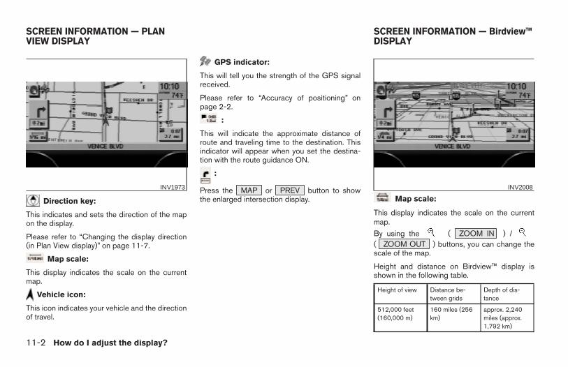
Direction key:
This indicates and sets the direction of the mapon the display.
Please refer to “Changing the display direction(in Plan View display)” on page 11-7.
Map scale:
This display indicates the scale on the currentmap.
Vehicle icon:
This icon indicates your vehicle and the directionof travel.
GPS indicator:
This will tell you the strength of the GPS signalreceived.
Please refer to “Accuracy of positioning” onpage 2-2.
:
This will indicate the approximate distance ofroute and traveling time to the destination. Thisindicator will appear when you set the destina-tion with the route guidance ON.
:
Press the MAP or PREV button to showthe enlarged intersection display. Map scale:
This display indicates the scale on the currentmap.
By using the ( ZOOM IN ) /( ZOOM OUT ) buttons, you can change thescale of the map.
Height and distance on Birdview™ display isshown in the following table.
Height of view Distance be-tween grids
Depth of dis-tance
512,000 feet(160,000 m)
160 miles (256km)
approx. 2,240miles (approx.1,792 km)
INV1973 INV2008
SCREEN INFORMATION — PLANVIEW DISPLAY
SCREEN INFORMATION — Birdview™DISPLAY
11-2 How do I adjust the display?
Z REVIEW COPY—2004 Maxima (max)Navigation System OM (navi)—USA_English (nna)04/27/04—tbrooks X
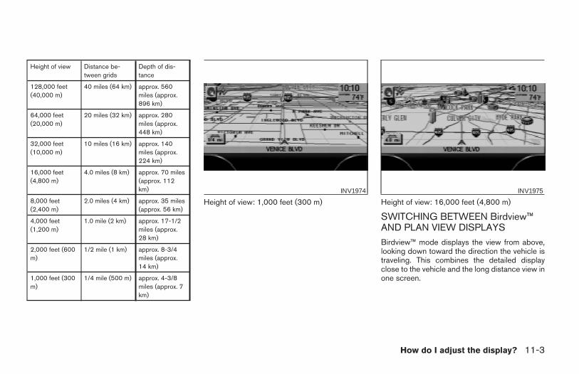
Height of view Distance be-tween grids
Depth of dis-tance
128,000 feet(40,000 m)
40 miles (64 km) approx. 560miles (approx.896 km)
64,000 feet(20,000 m)
20 miles (32 km) approx. 280miles (approx.448 km)
32,000 feet(10,000 m)
10 miles (16 km) approx. 140miles (approx.224 km)
16,000 feet(4,800 m)
4.0 miles (8 km) approx. 70 miles(approx. 112km)
8,000 feet(2,400 m)
2.0 miles (4 km) approx. 35 miles(approx. 56 km)
4,000 feet(1,200 m)
1.0 mile (2 km) approx. 17-1/2miles (approx.28 km)
2,000 feet (600m)
1/2 mile (1 km) approx. 8-3/4miles (approx.14 km)
1,000 feet (300m)
1/4 mile (500 m) approx. 4-3/8miles (approx. 7km)
Height of view: 1,000 feet (300 m) Height of view: 16,000 feet (4,800 m)
SWITCHING BETWEEN Birdview™AND PLAN VIEW DISPLAYSBirdview™ mode displays the view from above,looking down toward the direction the vehicle istraveling. This combines the detailed displayclose to the vehicle and the long distance view inone screen.
INV1974 INV1975
How do I adjust the display? 11-3
Z REVIEW COPY—2004 Maxima (max)Navigation System OM (navi)—USA_English (nna)04/27/04—tbrooks X
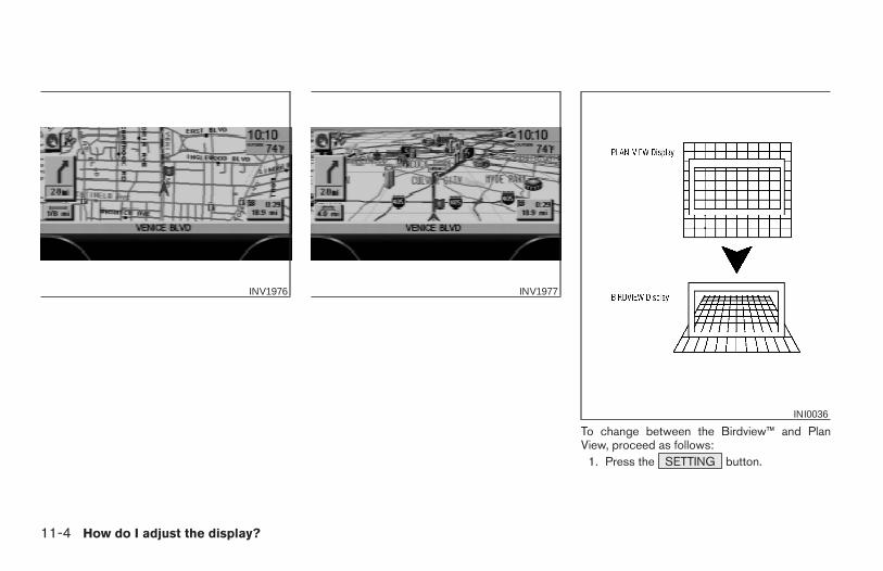
To change between the Birdview™ and PlanView, proceed as follows:
1. Press the SETTING button.
INV1976 INV1977
INI0036
11-4 How do I adjust the display?
Z REVIEW COPY—2004 Maxima (max)Navigation System OM (navi)—USA_English (nna)04/27/04—tbrooks X
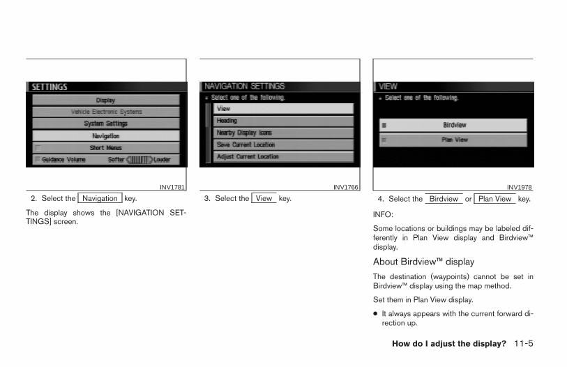
2. Select the Navigation key.
The display shows the [NAVIGATION SET-TINGS] screen.
3. Select the View key. 4. Select the Birdview or Plan View key.
INFO:
Some locations or buildings may be labeled dif-ferently in Plan View display and Birdview™display.
About Birdview™ display
The destination (waypoints) cannot be set inBirdview™ display using the map method.
Set them in Plan View display.
● It always appears with the current forward di-rection up.
INV1781 INV1766 INV1978
How do I adjust the display? 11-5
Z REVIEW COPY—2004 Maxima (max)Navigation System OM (navi)—USA_English (nna)04/27/04—tbrooks X
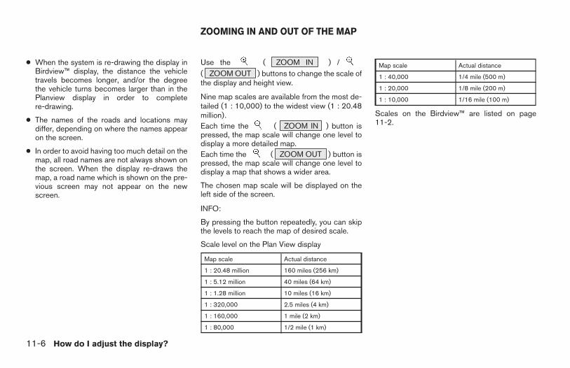
● When the system is re-drawing the display inBirdview™ display, the distance the vehicletravels becomes longer, and/or the degreethe vehicle turns becomes larger than in thePlanview display in order to completere-drawing.
● The names of the roads and locations maydiffer, depending on where the names appearon the screen.
● In order to avoid having too much detail on themap, all road names are not always shown onthe screen. When the display re-draws themap, a road name which is shown on the pre-vious screen may not appear on the newscreen.
Use the ( ZOOM IN ) /( ZOOM OUT ) buttons to change the scale ofthe display and height view.
Nine map scales are available from the most de-tailed (1 : 10,000) to the widest view (1 : 20.48million).Each time the ( ZOOM IN ) button ispressed, the map scale will change one level todisplay a more detailed map.Each time the ( ZOOM OUT ) button ispressed, the map scale will change one level todisplay a map that shows a wider area.
The chosen map scale will be displayed on theleft side of the screen.
INFO:
By pressing the button repeatedly, you can skipthe levels to reach the map of desired scale.
Scale level on the Plan View display
Map scale Actual distance
1 : 20.48 million 160 miles (256 km)
1 : 5.12 million 40 miles (64 km)
1 : 1.28 million 10 miles (16 km)
1 : 320,000 2.5 miles (4 km)
1 : 160,000 1 mile (2 km)
1 : 80,000 1/2 mile (1 km)
Map scale Actual distance
1 : 40,000 1/4 mile (500 m)
1 : 20,000 1/8 mile (200 m)
1 : 10,000 1/16 mile (100 m)
Scales on the Birdview™ are listed on page11-2.
ZOOMING IN AND OUT OF THE MAP
11-6 How do I adjust the display?
Z REVIEW COPY—2004 Maxima (max)Navigation System OM (navi)—USA_English (nna)04/27/04—tbrooks X
1. Press the SETTING button.
2. Select the Navigation key on the [SET-TINGS] screen.
Most detailed level (1: 10,000)
INV1979
The widest level (1: 20.48 million)
INV1980 INV1781
CHANGING THE DISPLAY DIRECTION(in Plan View display)
How do I adjust the display? 11-7
Z REVIEW COPY—2004 Maxima (max)Navigation System OM (navi)—USA_English (nna)04/27/04—tbrooks X
3. Select the Heading key on the [NAVIGA-TION SETTINGS] screen.
The [HEADING] screen will be displayed.
4. Select the Heading Up key or the
North Up key.
The map is displayed as follows:
Heading Up : The map shows the current for-ward direction up.
North Up : The map shows North up.
INV1981 INV1982
Display with North up
INV1983
11-8 How do I adjust the display?
Z REVIEW COPY—2004 Maxima (max)Navigation System OM (navi)—USA_English (nna)04/27/04—tbrooks X
INFO:
● When the key is selected, the amber indicatorlight will light up.
● When the MAP button is pressed after thedisplay setting, the [CURRENT LOCATION]screen will appear.
When the PREV button is pressed, theprevious screen will reappear.
You can manually scroll the map to check the lo-cation of your choice.
1. Operating the joystick.
The map scrolls in the same direction as the joy-stick movement.
INFO:
While the vehicle is traveling, a single operationwill move within the displayed area of the screen.
2. Press the MAP button to go back andshow the current vehicle position.
INFO:You can also select the PREV button to goback.
Display with the forward direction up
INV1984 INV1985
SCROLLING THE MAP
How do I adjust the display? 11-9
Z REVIEW COPY—2004 Maxima (max)Navigation System OM (navi)—USA_English (nna)04/27/04—tbrooks X
You can request to display the complete sug-gested route to the destination.
1. Press the ROUTE button.
Keys will be displayed on the screen.
2. Select the Route Info key.INV1986 INV1987
DISPLAYING THE COMPLETE ROUTETO THE DESTINATION
11-10 How do I adjust the display?
Z REVIEW COPY—2004 Maxima (max)Navigation System OM (navi)—USA_English (nna)04/27/04—tbrooks X
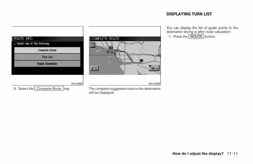
3. Select the Complete Route key. The complete suggested route to the destinationwill be displayed.
You can display the list of guide points to thedestination during or after route calculation.
1. Press the ROUTE button.
INV1988 INV1989
DISPLAYING TURN LIST
How do I adjust the display? 11-11
Z REVIEW COPY—2004 Maxima (max)Navigation System OM (navi)—USA_English (nna)04/27/04—tbrooks X
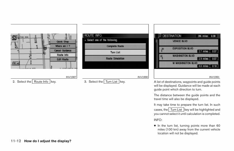
2. Select the Route Info key. 3. Select the Turn List key. A list of destinations, waypoints and guide pointswill be displayed. Guidance will be made at eachguide point which direction to turn.
The distance between the guide points and thetravel time will also be displayed.
It may take time to prepare the turn list. In such
cases, the Turn List key will be highlighted andyou cannot select it until calculation is completed.
INFO:
● In the turn list, turning points more than 60miles (100 km) away from the current vehiclelocation will not be displayed.
INV1987 INV1990 INV1991
11-12 How do I adjust the display?
Z REVIEW COPY—2004 Maxima (max)Navigation System OM (navi)—USA_English (nna)04/27/04—tbrooks X
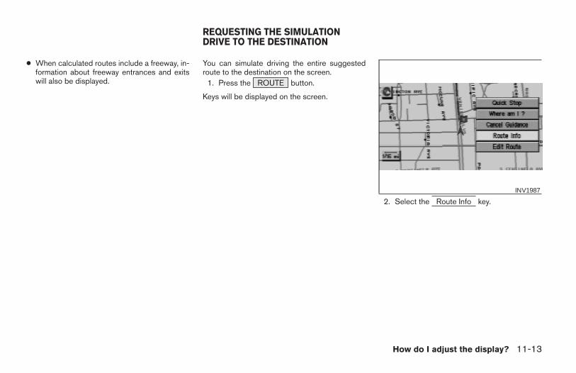
● When calculated routes include a freeway, in-formation about freeway entrances and exitswill also be displayed.
You can simulate driving the entire suggestedroute to the destination on the screen.
1. Press the ROUTE button.
Keys will be displayed on the screen.
2. Select the Route Info key.INV1987
REQUESTING THE SIMULATIONDRIVE TO THE DESTINATION
How do I adjust the display? 11-13
Z REVIEW COPY—2004 Maxima (max)Navigation System OM (navi)—USA_English (nna)04/27/04—tbrooks X
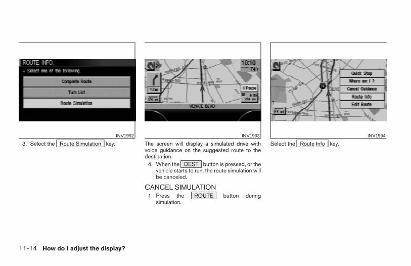
3. Select the Route Simulation key. The screen will display a simulated drive withvoice guidance on the suggested route to thedestination.
4. When the DEST button is pressed, or thevehicle starts to run, the route simulation willbe canceled.
CANCEL SIMULATION1. Press the ROUTE button during
simulation.
Select the Route Info key.INV1992 INV1993 INV1994
11-14 How do I adjust the display?
Z REVIEW COPY—2004 Maxima (max)Navigation System OM (navi)—USA_English (nna)04/27/04—tbrooks X
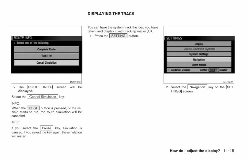
2. The [ROUTE INFO.] screen will bedisplayed.
Select the Cancel Simulation key.
INFO:When the DEST button is pressed, or the ve-hicle starts to run, the route simulation will becanceled.
INFO:
If you select the Pause key, simulation ispaused. If you select the key again, the simulationwill restart.
You can have the system track the road you havetaken, and display it with tracking marks (O).
1. Press the SETTING button.
2. Select the Navigation key on the [SET-TINGS] screen.
INV1995 INV1781
DISPLAYING THE TRACK
How do I adjust the display? 11-15
Z REVIEW COPY—2004 Maxima (max)Navigation System OM (navi)—USA_English (nna)04/27/04—tbrooks X
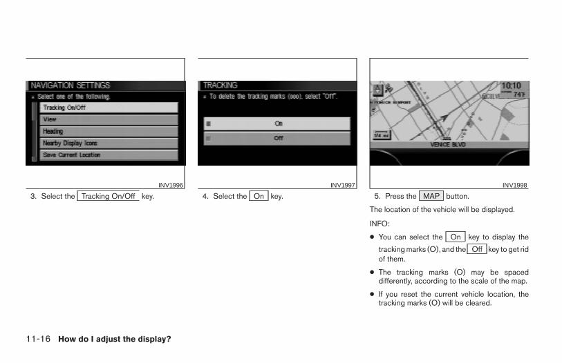
3. Select the Tracking On/Off key. 4. Select the On key. 5. Press the MAP button.
The location of the vehicle will be displayed.
INFO:
● You can select the On key to display the
tracking marks (O), and the Off key to get ridof them.
● The tracking marks (O) may be spaceddifferently, according to the scale of the map.
● If you reset the current vehicle location, thetracking marks (O) will be cleared.
INV1996 INV1997 INV1998
11-16 How do I adjust the display?
Z REVIEW COPY—2004 Maxima (max)Navigation System OM (navi)—USA_English (nna)04/27/04—tbrooks X
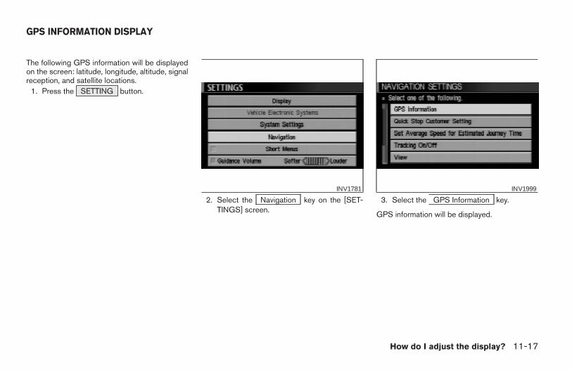
The following GPS information will be displayedon the screen: latitude, longitude, altitude, signalreception, and satellite locations.
1. Press the SETTING button.
2. Select the Navigation key on the [SET-TINGS] screen.
3. Select the GPS Information key.
GPS information will be displayed.
INV1781 INV1999
GPS INFORMATION DISPLAY
How do I adjust the display? 11-17
Z REVIEW COPY—2004 Maxima (max)Navigation System OM (navi)—USA_English (nna)04/27/04—tbrooks X
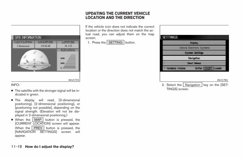
INFO:
● The satellite with the stronger signal will be in-dicated in green.
● The display will read, [3-dimensionalpositioning], [2-dimensional positioning], or[positioning not possible], depending on thesignal strength. (Elevation will not be dis-played in 2-dimensional positioning.)
● When the MAP button is pressed, the[CURRENT LOCATION] screen will appear.When the PREV button is pressed, the[NAVIGATION SETTINGS] screen willappear.
If the vehicle icon does not indicate the correctlocation or the direction does not match the ac-tual road, you can adjust them on the mapscreen.
1. Press the SETTING button.
2. Select the Navigation key on the [SET-TINGS] screen.
INV1721 INV1781
UPDATING THE CURRENT VEHICLELOCATION AND THE DIRECTION
11-18 How do I adjust the display?
Z REVIEW COPY—2004 Maxima (max)Navigation System OM (navi)—USA_English (nna)04/27/04—tbrooks X
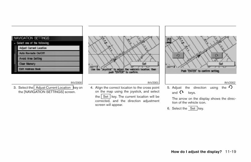
3. Select the Adjust Current Location key onthe [NAVIGATION SETTINGS] screen.
4. Align the correct location to the cross pointon the map using the joystick, and select
the Set key. The current location will becorrected, and the direction adjustmentscreen will appear.
5. Adjust the direction using the
and keys.
The arrow on the display shows the direc-tion of the vehicle icon.
6. Select the Set key.
INV2000 INV2001 INV2002
How do I adjust the display? 11-19
Z REVIEW COPY—2004 Maxima (max)Navigation System OM (navi)—USA_English (nna)04/27/04—tbrooks X
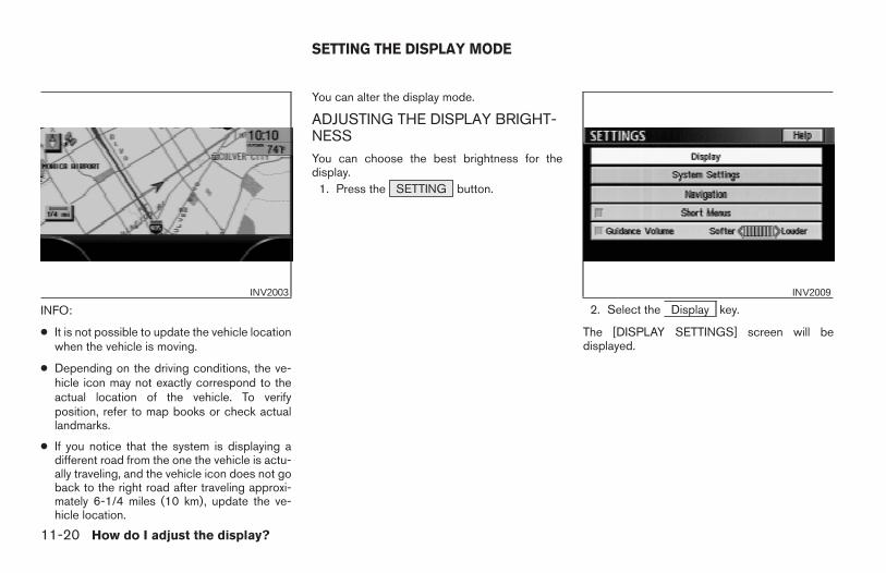
INFO:
● It is not possible to update the vehicle locationwhen the vehicle is moving.
● Depending on the driving conditions, the ve-hicle icon may not exactly correspond to theactual location of the vehicle. To verifyposition, refer to map books or check actuallandmarks.
● If you notice that the system is displaying adifferent road from the one the vehicle is actu-ally traveling, and the vehicle icon does not goback to the right road after traveling approxi-mately 6-1/4 miles (10 km), update the ve-hicle location.
You can alter the display mode.
ADJUSTING THE DISPLAY BRIGHT-NESSYou can choose the best brightness for thedisplay.
1. Press the SETTING button.
2. Select the Display key.
The [DISPLAY SETTINGS] screen will bedisplayed.
INV2003 INV2009
SETTING THE DISPLAY MODE
11-20 How do I adjust the display?
Z REVIEW COPY—2004 Maxima (max)Navigation System OM (navi)—USA_English (nna)04/27/04—tbrooks X
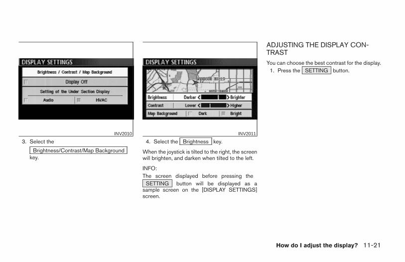
3. Select the
Brightness/Contrast/Map Backgroundkey.
4. Select the Brightness key.
When the joystick is tilted to the right, the screenwill brighten, and darken when tilted to the left.
INFO:The screen displayed before pressing the
SETTING button will be displayed as asample screen on the [DISPLAY SETTINGS]screen.
ADJUSTING THE DISPLAY CON-TRASTYou can choose the best contrast for the display.
1. Press the SETTING button.
INV2010 INV2011
How do I adjust the display? 11-21
Z REVIEW COPY—2004 Maxima (max)Navigation System OM (navi)—USA_English (nna)04/27/04—tbrooks X
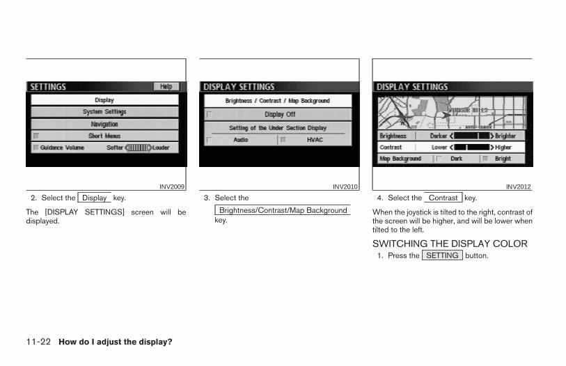
2. Select the Display key.
The [DISPLAY SETTINGS] screen will bedisplayed.
3. Select the
Brightness/Contrast/Map Backgroundkey.
4. Select the Contrast key.
When the joystick is tilted to the right, contrast ofthe screen will be higher, and will be lower whentilted to the left.
SWITCHING THE DISPLAY COLOR1. Press the SETTING button.
INV2009 INV2010 INV2012
11-22 How do I adjust the display?
Z REVIEW COPY—2004 Maxima (max)Navigation System OM (navi)—USA_English (nna)04/27/04—tbrooks X
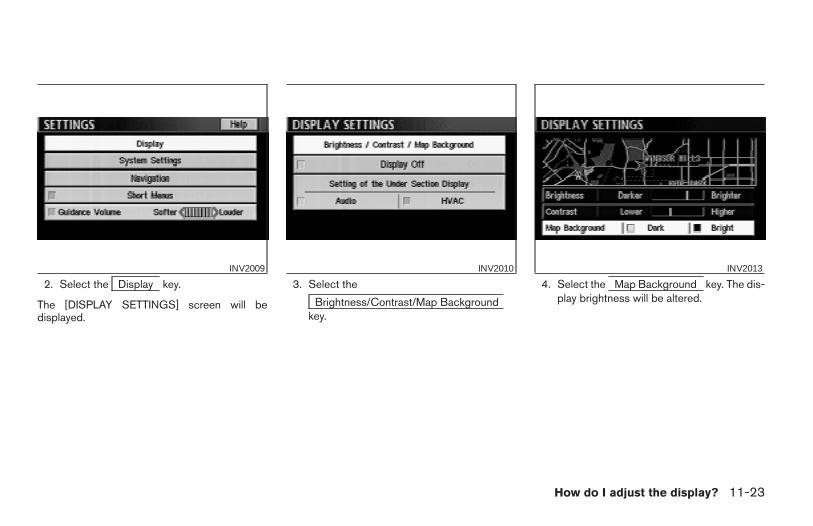
2. Select the Display key.
The [DISPLAY SETTINGS] screen will bedisplayed.
3. Select the
Brightness/Contrast/Map Backgroundkey.
4. Select the Map Background key. The dis-play brightness will be altered.
INV2009 INV2010 INV2013
How do I adjust the display? 11-23
Z REVIEW COPY—2004 Maxima (max)Navigation System OM (navi)—USA_English (nna)04/27/04—tbrooks X
The display uses liquid crystal and should behandled with care.
WARNING
Never disassemble the display. It hassome areas with extreme high voltage.Touching it may result in serious per-sonal injury.
CHARACTERISTICS OF LIQUIDCRYSTAL DISPLAY● If the temperature inside the vehicle is espe-
cially low, the display will stay relatively dim orthe movement of the images may be slow.These conditions are normal; when the tem-perature rises, the display will functionnormally.
● You may notice darker or brighter dots in partsof the display; this is inherent in monitor dis-plays and is not a malfunction.
● You may also notice a remnant of the previousdisplay image on the screen. This afterimageis inherent in displays and is not abnormal.
INFO:
The screen may become distorted by strongmagnetic fields.
MAINTENANCE OF THE DISPLAY
CAUTION
● To clean the display, never use arough cloth, alcohol, benzine,thinner, any kind of solvent, or papertowel with chemical cleaning agent.They will scratch or deteriorate thepanel.
● Do not splash any liquid such as wa-ter or car fragrance on the display.Contact with liquid will cause thesystem to malfunction.
If you need to clean the display screen, use a drysoft cloth. If additional cleaning is necessary, usea small amount of neutral detergent with a softcloth. Never soak the exterior with water ordetergent.
HOW TO HANDLE THE DISPLAY
11-24 How do I adjust the display?
Z REVIEW COPY—2004 Maxima (max)Navigation System OM (navi)—USA_English (nna)04/27/04—tbrooks X
12 Information on map data discs
How to order map data DVD-ROM updates . . . . . . . . . 12-2How to handle the DVD-ROM . . . . . . . . . . . . . . . . . . . . . 12-2
About the navigation map DVD-ROM . . . . . . . . . . . . 12-3
Icons. . . . . . . . . . . . . . . . . . . . . . . . . . . . . . . . . . . . . . . . .12-3Abbreviations definition list . . . . . . . . . . . . . . . . . . . . . . . . 12-6
Z REVIEW COPY—2004 Maxima (max)Navigation System OM (navi)—USA_English (nna)04/27/04—tbrooks X
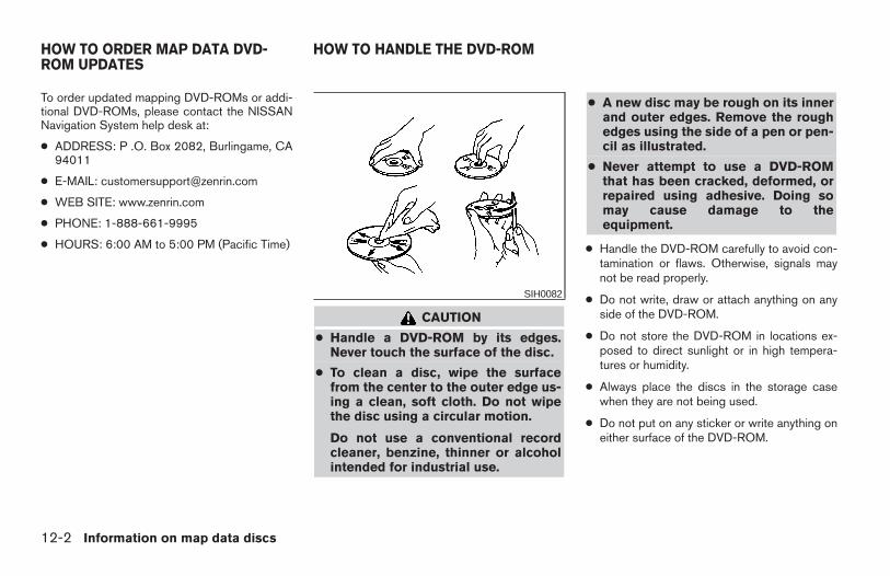
To order updated mapping DVD-ROMs or addi-tional DVD-ROMs, please contact the NISSANNavigation System help desk at:
● ADDRESS: P .O. Box 2082, Burlingame, CA94011
● E-MAIL: [email protected]
● WEB SITE: www.zenrin.com
● PHONE: 1-888-661-9995
● HOURS: 6:00 AM to 5:00 PM (Pacific Time)
CAUTION
● Handle a DVD-ROM by its edges.Never touch the surface of the disc.
● To clean a disc, wipe the surfacefrom the center to the outer edge us-ing a clean, soft cloth. Do not wipethe disc using a circular motion.
Do not use a conventional recordcleaner, benzine, thinner or alcoholintended for industrial use.
● A new disc may be rough on its innerand outer edges. Remove the roughedges using the side of a pen or pen-cil as illustrated.
● Never attempt to use a DVD-ROMthat has been cracked, deformed, orrepaired using adhesive. Doing somay cause damage to theequipment.
● Handle the DVD-ROM carefully to avoid con-tamination or flaws. Otherwise, signals maynot be read properly.
● Do not write, draw or attach anything on anyside of the DVD-ROM.
● Do not store the DVD-ROM in locations ex-posed to direct sunlight or in high tempera-tures or humidity.
● Always place the discs in the storage casewhen they are not being used.
● Do not put on any sticker or write anything oneither surface of the DVD-ROM.
SIH0082
HOW TO ORDER MAP DATA DVD-ROM UPDATES
HOW TO HANDLE THE DVD-ROM
12-2 Information on map data discs
Z REVIEW COPY—2004 Maxima (max)Navigation System OM (navi)—USA_English (nna)04/27/04—tbrooks X
ABOUT THE NAVIGATION MAPDVD-ROM
1. This navigation map DVD-ROM has beenprepared by ZENRIN CO., LTD. under li-cense from Navigation TechnologiesCorporation. ZENRIN CO., LTD. has added,processed and digitized data based on thedigital road map data of Navigation Tech-nologies Corporation. Due to the produc-tion timing of the map data, some new roadsmay not be included in this map data orsome of the names or roads may be differ-ent from those at the time you use thisDVD-ROM.
2. Traffic control and regulation data used inthis DVD-ROM may be different from thoseat the time you use this DVD-ROM due tothe data production timing. When drivingyour vehicle, follow the actual traffic controlsigns and notices on the roads.
3. Reproducing or copying this map softwareis strictly prohibited by law.
Published by NISSAN North America, Inc.
© 2002 Navigation Technologies. All rightsreserved. “Certain business data provided byinfoUSA.com, Inc. Copyright 2002, All rightsreserved”.
ICONSIcon legend follows:
Information on map data discs 12-3
Z REVIEW COPY—2004 Maxima (max)Navigation System OM (navi)—USA_English (nna)04/27/04—tbrooks X
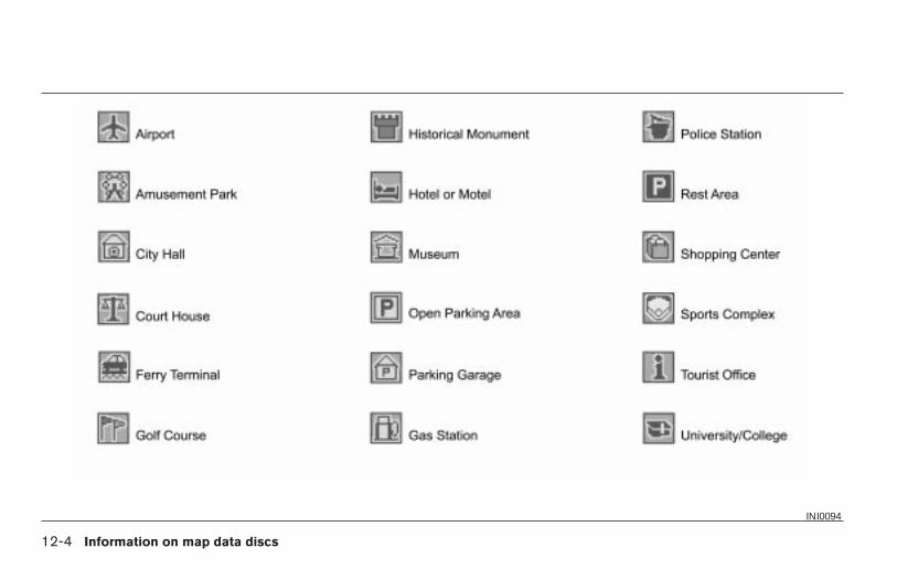
INI0094
12-4 Information on map data discs
Z REVIEW COPY—2004 Maxima (max)Navigation System OM (navi)—USA_English (nna)04/27/04—tbrooks X
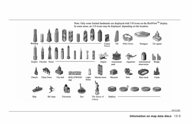
INV1183
Information on map data discs 12-5
Z REVIEW COPY—2004 Maxima (max)Navigation System OM (navi)—USA_English (nna)04/27/04—tbrooks X
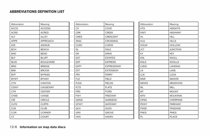
Abbreviation Meaning
ACCS ACCESS
ACRS ACRES
ALY ALLEY
APPR APPROACH
AVE AVENUE
BCH BEACH
BND BEND
BLF BLUFF
BLVD BOULEVARD
BRG BRIDGE
BRK BROOK
BYP BYPASS
BYWY BYWAY
CYN CANYON
CSWY CAUSEWAY
CTR CENTER
CHSE CHASE
CIR CIRCLE
CLFS CLIFFS
CLB CLUB
COR CORNER
CT COURT
Abbreviation Meaning
CV COVE
CRK CREEK
CRES CRESCENT
XING CROSSING
CURV CURVE
DL DALE
DR DRIVE
EST ESTATES
EXP EXPRESS
EXPY EXPRESSWAY
EXT EXTENSION
FRY FERRY
FLD FIELD
FLDS FIELDS
FLTS FLATS
FRD FORD
FWY FREEWAY
GDNS GARDENS
GTWY GATEWAY
GLN GLEN
GRV GROVE
HVN HAVEN
Abbreviation Meaning
HTS HEIGHTS
HWY HIGHWAY
HL HILL
HLS HILLS
HOLW HOLLOW
JCT JUNCTION
KY KEY
KNL KNOLL
KNLS KNOLLS
LNDG LANDING
LN LANE
LCK LOCK
MNR MANOR
MDWS MEADOWS
ML MILL
MT MOUNT
MTN MOUNTAIN
OPAS OVERPASS
PKWY PARKWAY
PSGE PASSAGE
PNES PINES
PL PLACE
ABBREVIATIONS DEFINITION LIST
12-6 Information on map data discs
Z REVIEW COPY—2004 Maxima (max)Navigation System OM (navi)—USA_English (nna)04/27/04—tbrooks X
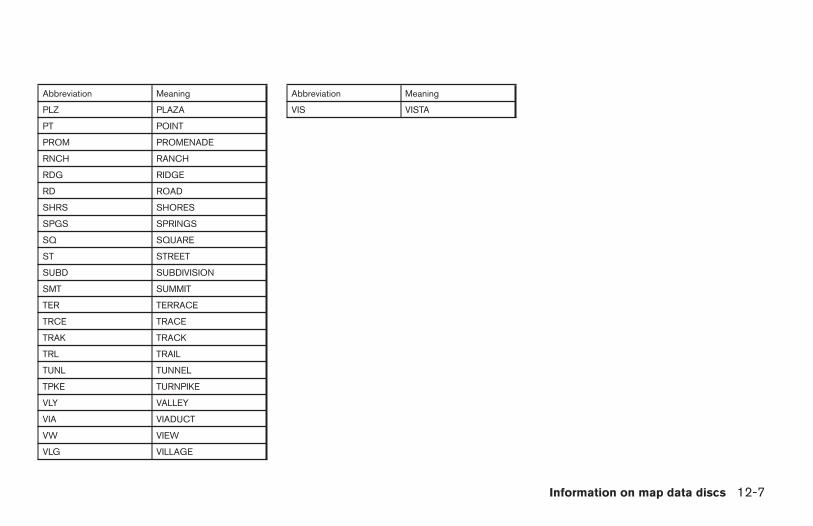
Abbreviation Meaning
PLZ PLAZA
PT POINT
PROM PROMENADE
RNCH RANCH
RDG RIDGE
RD ROAD
SHRS SHORES
SPGS SPRINGS
SQ SQUARE
ST STREET
SUBD SUBDIVISION
SMT SUMMIT
TER TERRACE
TRCE TRACE
TRAK TRACK
TRL TRAIL
TUNL TUNNEL
TPKE TURNPIKE
VLY VALLEY
VIA VIADUCT
VW VIEW
VLG VILLAGE
Abbreviation Meaning
VIS VISTA
Information on map data discs 12-7
Z REVIEW COPY—2004 Maxima (max)Navigation System OM (navi)—USA_English (nna)04/27/04—tbrooks X

12-8 Information on map data discs
MEMO
13 Troubleshooting guide
Customer assistance . . . . . . . . . . . . . . . . . . . . . . . . . . . . .13-2Basic operations . . . . . . . . . . . . . . . . . . . . . . . . . . . . . . . . .13-3Vehicle icon. . . . . . . . . . . . . . . . . . . . . . . . . . . . . . . . . . . . . .13-4Map DVD-ROM . . . . . . . . . . . . . . . . . . . . . . . . . . . . . . . . . .13-6
Destination, waypoints or menu contents cannot bechosen or set . . . . . . . . . . . . . . . . . . . . . . . . . . . . . . . . . . . .13-7Voice guidance. . . . . . . . . . . . . . . . . . . . . . . . . . . . . . . . . . .13-8Route calculation . . . . . . . . . . . . . . . . . . . . . . . . . . . . . . . . .13-9
Z REVIEW COPY—2004 Maxima (max)Navigation System OM (navi)—USA_English (nna)04/27/04—tbrooks X

For assistance or inquiries about the NISSANNavigation System, please contact NISSANcustomer assistance at:
● ADDRESS: P.O. Box 191, Gardena, CA90247
● WEB SITE: www.nissan-usa.com
● PHONE: 1–800–NISSAN-1(1–800–647–7261)
CUSTOMER ASSISTANCE
13-2 Troubleshooting guide
Z REVIEW COPY—2004 Maxima (max)Navigation System OM (navi)—USA_English (nna)04/27/04—tbrooks X
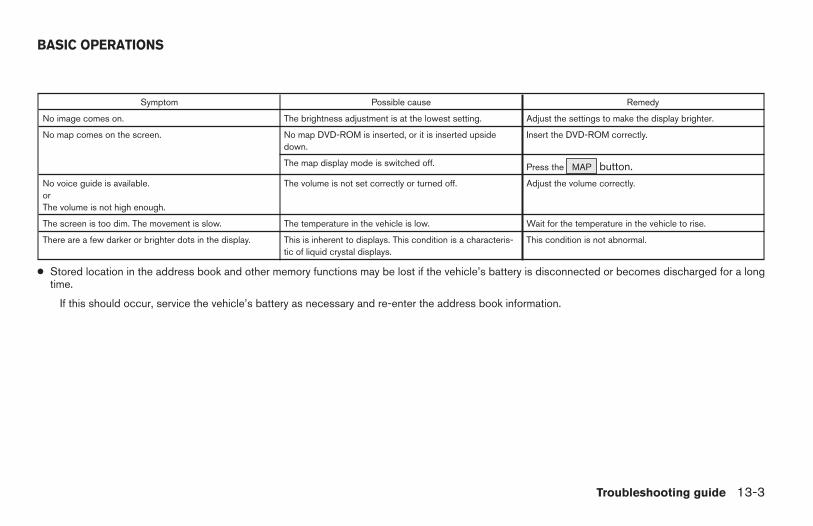
Symptom Possible cause Remedy
No image comes on. The brightness adjustment is at the lowest setting. Adjust the settings to make the display brighter.
No map comes on the screen. No map DVD-ROM is inserted, or it is inserted upsidedown.
Insert the DVD-ROM correctly.
The map display mode is switched off. Press the MAP button.No voice guide is available.orThe volume is not high enough.
The volume is not set correctly or turned off. Adjust the volume correctly.
The screen is too dim. The movement is slow. The temperature in the vehicle is low. Wait for the temperature in the vehicle to rise.
There are a few darker or brighter dots in the display. This is inherent to displays. This condition is a characteris-tic of liquid crystal displays.
This condition is not abnormal.
● Stored location in the address book and other memory functions may be lost if the vehicle’s battery is disconnected or becomes discharged for a longtime.
If this should occur, service the vehicle’s battery as necessary and re-enter the address book information.
BASIC OPERATIONS
Troubleshooting guide 13-3
Z REVIEW COPY—2004 Maxima (max)Navigation System OM (navi)—USA_English (nna)04/27/04—tbrooks X
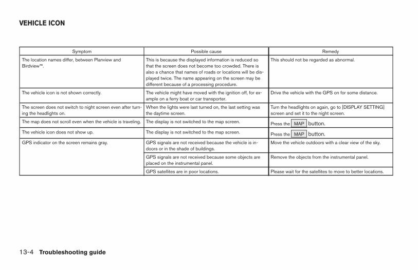
Symptom Possible cause Remedy
The location names differ, between Planview andBirdview™.
This is because the displayed information is reduced sothat the screen does not become too crowded. There isalso a chance that names of roads or locations will be dis-played twice. The name appearing on the screen may bedifferent because of a processing procedure.
This should not be regarded as abnormal.
The vehicle icon is not shown correctly. The vehicle might have moved with the ignition off, for ex-ample on a ferry boat or car transporter.
Drive the vehicle with the GPS on for some distance.
The screen does not switch to night screen even after turn-ing the headlights on.
When the lights were last turned on, the last setting wasthe daytime screen.
Turn the headlights on again, go to [DISPLAY SETTING]screen and set it to the night screen.
The map does not scroll even when the vehicle is traveling. The display is not switched to the map screen. Press the MAP button.The vehicle icon does not show up. The display is not switched to the map screen. Press the MAP button.GPS indicator on the screen remains gray. GPS signals are not received because the vehicle is in-
doors or in the shade of buildings.Move the vehicle outdoors with a clear view of the sky.
GPS signals are not received because some objects areplaced on the instrumental panel.
Remove the objects from the instrumental panel.
GPS satellites are in poor locations. Please wait for the satellites to move to better locations.
VEHICLE ICON
13-4 Troubleshooting guide
Z REVIEW COPY—2004 Maxima (max)Navigation System OM (navi)—USA_English (nna)04/27/04—tbrooks X
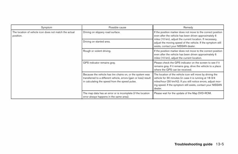
Symptom Possible cause Remedy
The location of vehicle icon does not match the actualposition.
Driving on slippery road surface. If the position marker does not move to the correct positioneven after the vehicle has been driven approximately 6miles (10 km), adjust the current location. If necessary,adjust the moving speed of the vehicle. If the symptom stillexists, contact your NISSAN dealer.
Driving on slanted area.
Rough or violent driving. If the position marker does not move to the correct positioneven after the vehicle has been driven approximately 6miles (10 km), adjust the current location.
GPS indicator remains gray. Please check the GPS indicator on the screen to see if itremains gray. If it remains gray, drive the vehicle to a placewhere the GPS can be received.
Because the vehicle has tire chains on, or the system wastransferred to a different vehicle, errors (gain or loss) resultin calculating the speed from the speed pulse.
The location of the vehicle icon will move by driving thevehicle for 30 minutes (in case it is running at 18-3/4miles/hour (30 km/h)). If you still notice errors, adjust mov-ing speed. If the symptom still exists, contact your NISSANdealer.
The map data has an error or is incomplete (if the locationerror always happens in the same area).
Please wait for the update of the Map DVD-ROM.
Troubleshooting guide 13-5
Z REVIEW COPY—2004 Maxima (max)Navigation System OM (navi)—USA_English (nna)04/27/04—tbrooks X
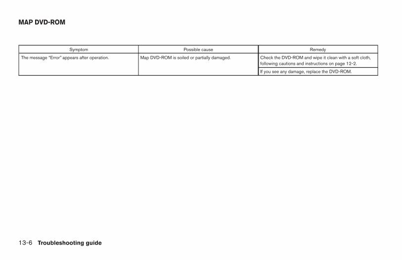
Symptom Possible cause Remedy
The message “Error” appears after operation. Map DVD-ROM is soiled or partially damaged. Check the DVD-ROM and wipe it clean with a soft cloth,following cautions and instructions on page 12-2.
If you see any damage, replace the DVD-ROM.
MAP DVD-ROM
13-6 Troubleshooting guide
Z REVIEW COPY—2004 Maxima (max)Navigation System OM (navi)—USA_English (nna)04/27/04—tbrooks X
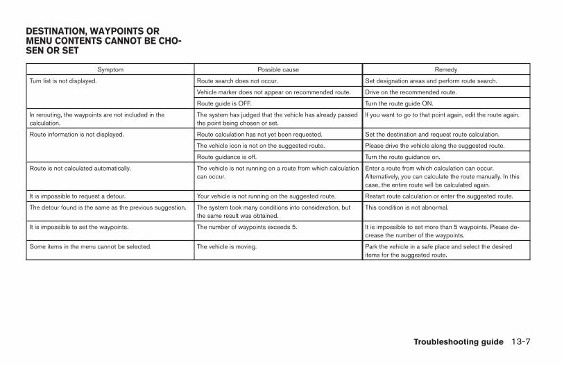
Symptom Possible cause Remedy
Turn list is not displayed. Route search does not occur. Set designation areas and perform route search.
Vehicle marker does not appear on recommended route. Drive on the recommended route.
Route guide is OFF. Turn the route guide ON.
In rerouting, the waypoints are not included in thecalculation.
The system has judged that the vehicle has already passedthe point being chosen or set.
If you want to go to that point again, edit the route again.
Route information is not displayed. Route calculation has not yet been requested. Set the destination and request route calculation.
The vehicle icon is not on the suggested route. Please drive the vehicle along the suggested route.
Route guidance is off. Turn the route guidance on.
Route is not calculated automatically. The vehicle is not running on a route from which calculationcan occur.
Enter a route from which calculation can occur.Alternatively, you can calculate the route manually. In thiscase, the entire route will be calculated again.
It is impossible to request a detour. Your vehicle is not running on the suggested route. Restart route calculation or enter the suggested route.
The detour found is the same as the previous suggestion. The system took many conditions into consideration, butthe same result was obtained.
This condition is not abnormal.
It is impossible to set the waypoints. The number of waypoints exceeds 5. It is impossible to set more than 5 waypoints. Please de-crease the number of the waypoints.
Some items in the menu cannot be selected. The vehicle is moving. Park the vehicle in a safe place and select the desireditems for the suggested route.
DESTINATION, WAYPOINTS ORMENU CONTENTS CANNOT BE CHO-SEN OR SET
Troubleshooting guide 13-7
Z REVIEW COPY—2004 Maxima (max)Navigation System OM (navi)—USA_English (nna)04/27/04—tbrooks X
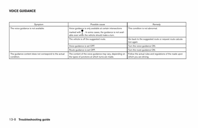
Symptom Possible cause Remedy
The voice guidance is not available. Voice guidance is only available at certain intersections
marked with . In some cases, the guidance is not avail-able even when the vehicle should make a turn.
This condition is not abnormal.
The vehicle is off the suggested route. Go back to the suggested route or request route calcula-tion again.
Voice guidance is set OFF. Turn the voice guidance ON.
Route guidance is set OFF. Turn the route guidance ON.
The guidance content does not correspond to the actualcondition.
The content of the voice guidance may vary, depending onthe types of junctions at which turns are made.
Follow the actual rules and regulations of the roads uponwhich you are driving.
VOICE GUIDANCE
13-8 Troubleshooting guide
Z REVIEW COPY—2004 Maxima (max)Navigation System OM (navi)—USA_English (nna)04/27/04—tbrooks X
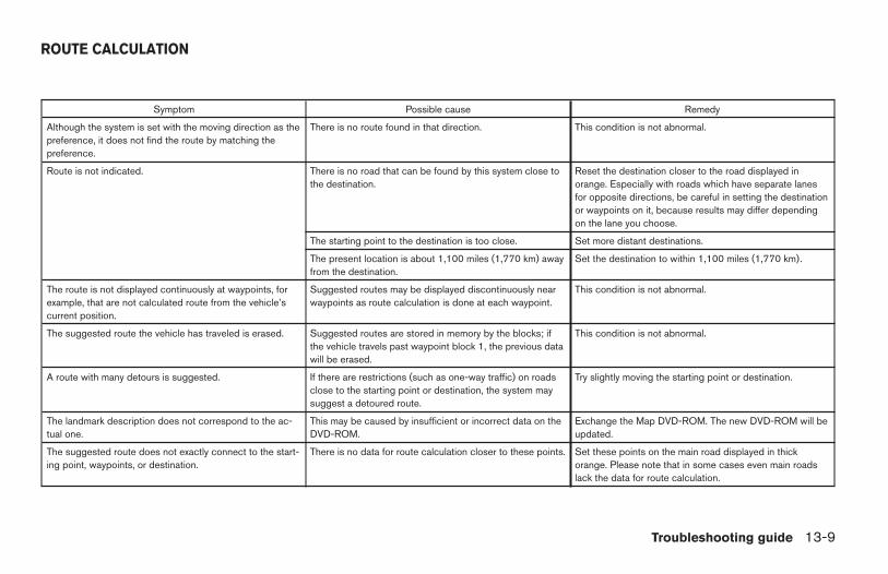
Symptom Possible cause Remedy
Although the system is set with the moving direction as thepreference, it does not find the route by matching thepreference.
There is no route found in that direction. This condition is not abnormal.
Route is not indicated. There is no road that can be found by this system close tothe destination.
Reset the destination closer to the road displayed inorange. Especially with roads which have separate lanesfor opposite directions, be careful in setting the destinationor waypoints on it, because results may differ dependingon the lane you choose.
The starting point to the destination is too close. Set more distant destinations.
The present location is about 1,100 miles (1,770 km) awayfrom the destination.
Set the destination to within 1,100 miles (1,770 km).
The route is not displayed continuously at waypoints, forexample, that are not calculated route from the vehicle’scurrent position.
Suggested routes may be displayed discontinuously nearwaypoints as route calculation is done at each waypoint.
This condition is not abnormal.
The suggested route the vehicle has traveled is erased. Suggested routes are stored in memory by the blocks; ifthe vehicle travels past waypoint block 1, the previous datawill be erased.
This condition is not abnormal.
A route with many detours is suggested. If there are restrictions (such as one-way traffic) on roadsclose to the starting point or destination, the system maysuggest a detoured route.
Try slightly moving the starting point or destination.
The landmark description does not correspond to the ac-tual one.
This may be caused by insufficient or incorrect data on theDVD-ROM.
Exchange the Map DVD-ROM. The new DVD-ROM will beupdated.
The suggested route does not exactly connect to the start-ing point, waypoints, or destination.
There is no data for route calculation closer to these points. Set these points on the main road displayed in thickorange. Please note that in some cases even main roadslack the data for route calculation.
ROUTE CALCULATION
Troubleshooting guide 13-9
Z REVIEW COPY—2004 Maxima (max)Navigation System OM (navi)—USA_English (nna)04/27/04—tbrooks X

13-10 Troubleshooting guide
MEMO
14 Index
A
Address book (Editing) . . . . . . . . . . . . .7-8Address book (Setting) . . . . . . . . . . . . .7-2Address/Street . . . . . . . . . . . . . . . . . .5-7Automatic re-routing . . . . . . . . . . . . . . .9-2Avoid areas (Editing) . . . . . . . . . . . . . . .8-5Avoid areas (Setting) . . . . . . . . . . . . . . .8-2
B
Birdview™ display . . . . . . . . . . . . . . . .11-2
C
Clear memory . . . . . . . . . . . . . . . . . .4-16Complete route . . . . . . . . . . . . . . . .11-10
D
Destination (Adjusting) . . . . . . . . . . . . .5-38Destination (Deleting) . . . . . . . . . . . . .5-38Destination (Setting) . . . . . . . . . . . . . . .5-2Detour . . . . . . . . . . . . . . . . . . . . . . .9-3Display (Direction) . . . . . . . . . . . . . . .11-7Display (Error) . . . . . . . . . . . . . . . . . .4-21Display (Maintenance) . . . . . . . . . . . .11-24
E
Enlarged intersection display . . . . . . . . .5-36
G
GPS (Global Positioning System). . . . . . . .2-2
H
Heading . . . . . . . . . . . . . . . . . . . . .11-7
I
Icon (Changing) . . . . . . . . . . . . . . . . .7-9Icon (Legend) . . . . . . . . . . . . . .12-6, 7-13Information on screen(Planview/Birdview™) . . . . . . . . . . . . . .11-2Intersection . . . . . . . . . . . . . . . . . . .5-14
J
Joystick . . . . . . . . . . . . . . . . . . . . . .4-3
L
Liquid crystal display (LCD) . . . . . . . . .11-24
M
Map coverage areas . . . . . . . . . . . . . . .2-3Map DVD-ROM. . . . . . . . . . . . . . . . .13-6
N
Nearby display icons . . . . . . . . . . . . . .6-12
P
Point of interest (POI) . . . . . . . . . . . . . .6-2Preference for route calculation . . . . . . . .5-35Previous Dest. . . . . . . . . . . . . . . . . . .5-5
Q
Quick stop. . . . . . . . . . . . . . . . . . . .5-41Quick stop customer settings . . . . . . . . .5-43
R
Reference symbols . . . . . . . . . . . . . . . .1-2Route calculation and guidance . . . . . . . .5-35Route guidance . . . . . . . . . . . . . .3-2, 4-19
Z REVIEW COPY—2004 Maxima (max)Navigation System OM (navi)—USA_English (nna)04/27/04—tbrooks X
S
Safe operation . . . . . . . . . . . . . . . . . .1-2Safety note . . . . . . . . . . . . . . . . . . . .1-2Simulation drive . . . . . . . . . . . . . . . .11-13Storing current vehicle position . . . . . . . . .7-4
T
Tracking . . . . . . . . . . . . . . . . . . . .11-15Turn list . . . . . . . . . . . . . . . . . . . . .11-11
U
Updating the current vehicle location and the di-rection . . . . . . . . . . . . . . . . . . . . .11-18
V
Voice guidance (Notes) . . . . . . . . . . . .11-2
W
Waypoint (Adjusting) . . . . . . . . . . . . . .5-38Waypoint (Deleting) . . . . . . . . . . . . . .5-38Waypoint (Setting) . . . . . . . . . . . . . . .5-32Where am I? . . . . . . . . . . . . . . . . . .5-45
Z
Zoom in (IN) . . . . . . . . . . . . . . . . . . .11-6Zoom out (OUT) . . . . . . . . . . . . . . . .11-6
14-2
Z REVIEW COPY—2004 Maxima (max)Navigation System OM (navi)—USA_English (nna)04/27/04—tbrooks X
KEYAddress Book key . . . . . . . . . . . .5-3
Address/Street key . . . . . . . . . . .5-7
Adjust Current Location key . . . .11-19
All Clear key . . . . . . . . . . . . . . .5-41
Area key . . . . . . . . . . . . . . .8-4 , 8-9
Auto Re-route On/Off key . . . . . . .9-2
Avoid Area Setting key . . . . . . . . .8-2
Avoid Freeway key . . . . . . . .8-4 , 8-9
Avoid the Current Street key . . . . .9-4
Birdview key . . . . . . . . . . . . . . .11-5
Cancel Guidance key . . . . . . . . .5-45
Cancel Simulation key . . . . . . .11-15
Category key . . . . . . . . . . . . . . .6-5
City key . . . . . . . . . . . . . . . . . .5-22
Clear Memory key . . . . . . . . . . . .4-6
Complete Route key . . . . . . . . .11-11
Country key . . . . . . . . . . . . . . .5-29
Destination key . . . . . . . . . . . . . .5-5
Detour key . . . . . . . . . . . . . . . . .9-4
ENTER key . . . . . . . . . . . . . . . .4-13
Edit Address Book key . . . . . . . . .7-3
Edit Route key. . . . . . . . . . . . . . .9-4
GPS Information key. . . . . . . . .11-17
Guidance Volume key . . . . . . . . .10-2
Heading key . . . . . . . . . . . . . . .11-8
Heading Up key. . . . . . . . . . . . .11-8
Home key. . . . . . . . . . . . . . . . .5-30
I AGREE key. . . . . . . . . . . . . . .4-13
Intersection key . . . . . . . . . . . . .5-14
Landmark Icon key . . . . . . . . . . .7-11
List key . . . . . . . . . . . . . . . . . . .6-2
Louder key . . . . . . . . . . . . . . . .10-2
Map key . . . . . . . . . . . . . . . . . .5-27
Minimize FWY key . . . . . . . . . . .5-34
Minimize Toll Road key . . . . . . . .5-34
Navigation key. . . . . . . . . . . . . . .4-5
Nearby key . . . . . . . . . . . . . . . .6-12
Nearby Display Icons key . . . . . .6-14
North Up key. . . . . . . . . . . . . . .11-8
Pause key. . . . . . . . . . . . . . . .11-15
Phone Number key. . . . . . . . . . .5-25
Plan View key . . . . . . . . . . . . . .11-5
key . . . . . . . . .6-2
Previous Dest. key . . . . . . . . . . . .5-5
Priorities key . . . . . . . . . . . . . . .5-34
Quick Stop key . . . . . . . . . . . . .5-41
Quick Stop Customer Setting key.5-43
Rename key . . . . . . . . . . . .7-9 , 8-6
Return All Settings to Default key .4-19
Route Info key . . . . . . . . . . . . . . .4-9
Route Simulation key . . . . . . . .11-14
Route calc. key . . . . . . . . . . . . .5-35
Save Current Location key . . . . . .7-4
Set Average Speed for Estimated Journey Time
key . . . . . . . . . . . . . . . . . . . . . . .4-19
Short Menus key . . . . . . . . . . . . .3-5
Shortest Distance key. . . . . . . . .5-34
Shortest Time key . . . . . . . . . . .5-34
Softer key. . . . . . . . . . . . . . . . .10-2
Sort key . . . . . . . . . . . . . . . . . . .7-7
State key . . . . . . . . . . . . . . . . . .6-3
Store Place key . . . . . . . . . . . . . .7-5
14-3
Z REVIEW COPY—2004 Maxima (max)Navigation System OM (navi)—USA_English (nna)04/27/04—tbrooks X

Tracking On/Off key . . . . . . . . .11-16
Turn List key . . . . . . . . . . . . . .11-12
Use Ferry Route key . . . . . . . . . .5-35
Use Time Restricted Roads key . .5-34
View key . . . . . . . . . . . . . . . . .11-5
Waypoint key . . . . . . . . . . . . . .5-29
Where am I? key . . . . . . . . . . . .5-45
BUTTONDAY/NIGHT . . . . . . . . . . . . . . . .4-3DEST . . . . . . . . . . . . . . . . . . . .4-7EJECT . . . . . . . . . . . . . . . . . . .4-3GUIDE VOICE . . . . . . . . . . . . .10-3
JOYSTICK and ENTER . . . . . . . . .4-3MAP . . . . . . . . . . . . . . . . . . . .5-37PREV . . . . . . . . . . . . . . . . . . . .4-4ROUTE . . . . . . . . . . . . . . . . . . .4-8SETTING . . . . . . . . . . . . . . . . .4-4TRIP . . . . . . . . . . . . . . . . . . . . .4-3ZOOM IN . . . . . . . . . . . . . . .11-6ZOOM OUT . . . . . . . . . . . . . . .11-6
14-4
Z REVIEW COPY—2004 Maxima (max)Navigation System OM (navi)—USA_English (nna)04/27/04—tbrooks X