Embed Size (px)
Citation preview
2 Geology of groundwater As we’ve already discussed, aquifers can be divided into two main types depending on their host materials. Unconsolidated sediments overly bedrock in many areas, and can be very important aquifers because of their relatively high porosities and permeabilities. On the other hand, bedrock aquifers are generally thicker and much more voluminous than surficial aquifers, and even though they typically have lower porosities and permeabilities, they can contain a much greater volume of useable water.
The eastern edge of central Vancouver Island has two main aquifer types. Much of the area is underlain by the clastic sedimentary rock Nanaimo Group, and this is an important source of water for many people living in rural areas, especially those on the Gulf Islands. While most of the Gulf Islands and some parts of Vancouver Island have only a very thin layer of drift (a metre or two), and that is mostly glacial till, some regions have thick drift deposits of glacial and fluvial origin, and some of these are significant sources of groundwater. The Parksville, Qualicum and Comox Valley areas have important glacio-fluvial aquifers, and the Cassidy area has an important fluvial aquifer. Most Vancouver Island urban areas - and hence most Vancouver Island residents - get their water from surface supplies, such as the Nanaimo River. (see below)
Bedrock aquifers Surficial aquifers Surface water
Malaspina University-College – GEOL-304 – HYDROGEOLOGY – Steven Earle - 2006
2
2.1 Surficial aquifers
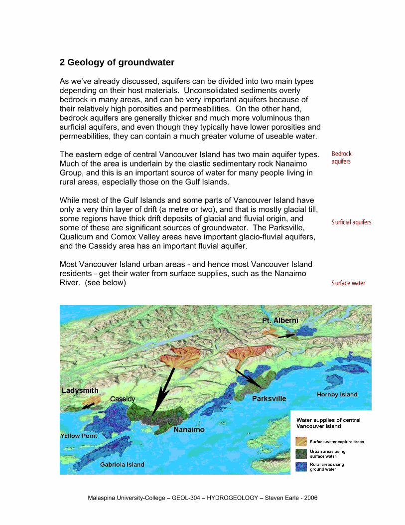
Surficial aquifers (a.k.a. unconsolidated aquifers or drift aquifers) are made up of geological deposits that have not been lithified, in most cases because they are relatively young (typically less than 1 m.y. old), but in some cases because they have never been buried deeply enough to have the relatively warm water percolating through them that is necessary to cement the grains together. Surficial deposits that can make good aquifers include some glacial deposits, most alluvial (ie. river transported) deposits, most eolian (ie. wind blown) deposits, most beach deposits, and some colluvial (ie. gravity) deposits. Since most surficial aquifers in Canada are developed in either glacial or alluvial sediments we will limit this discussion to those two types.
Surficial deposits Types of surficial deposits
Glacial deposits come in two main types, name those that are moved by ice, and those that are moved by water that is derived from the glacier.
Glacial deposits
Perspective diagram of the front margin of a glacier
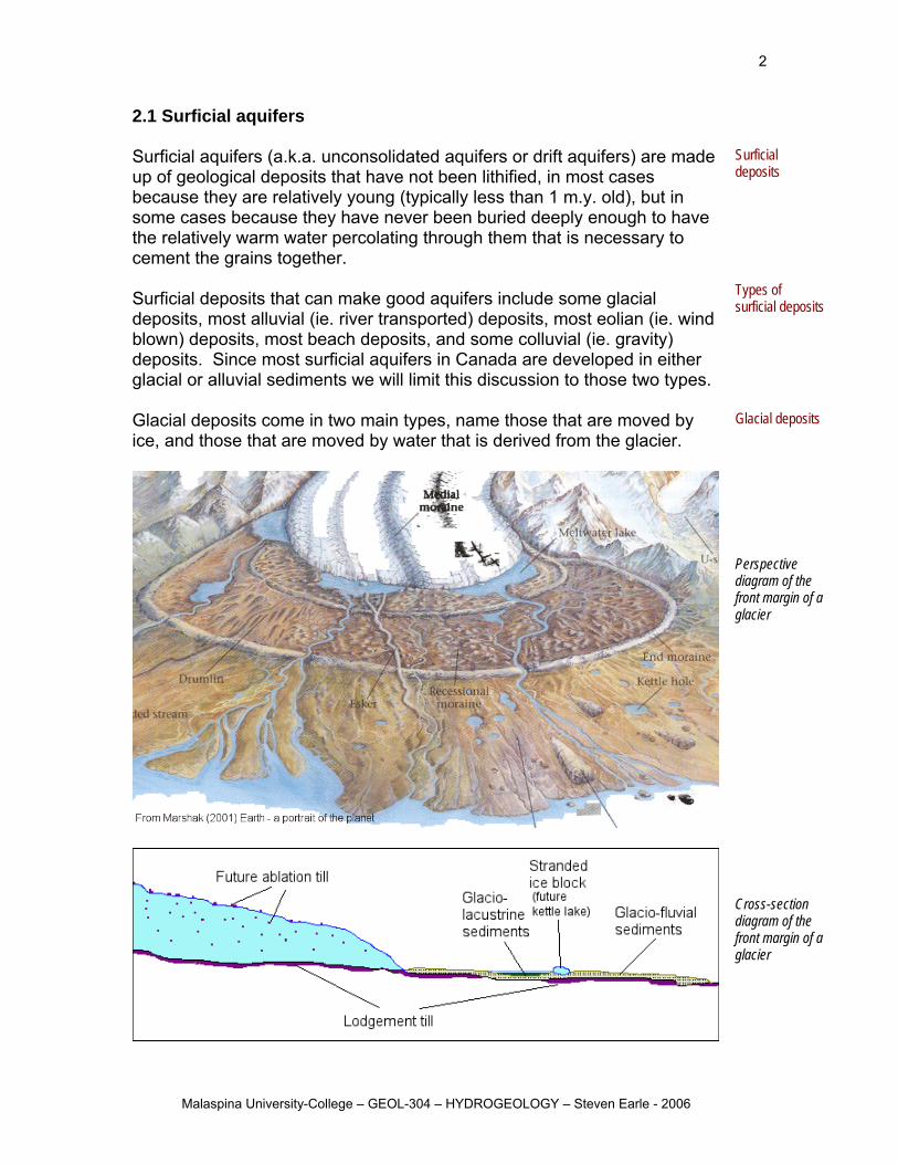
Cross-section diagram of the front margin of a glacier
Malaspina University-College – GEOL-304 – HYDROGEOLOGY – Steven Earle - 2006
3
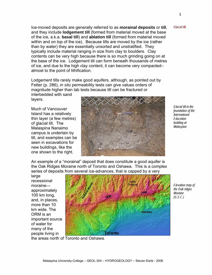
Ice-moved deposits are generally referred to as morainal deposits or till, and they include lodgement till (formed from material moved at the base of the ice, a.k.a. basal till) and ablation till (formed from material moved within and on top of the ice). Because tills are moved by the ice (rather than by water) they are essentially unsorted and unstratified. They typically include material ranging in size from clay to boulders. Clay contents can be very high because there is so much grinding going on at the base of the ice. Lodgement till can form beneath thousands of metres of ice, and due to the high clay content, it can become very compacted–almost to the point of lithification. Lodgement tills rarely make good aquifers, although, as pointed out by Fetter (p. 286), in situ permeability tests can give values orders of magnitude higher than lab tests because till can be fractured or interbedded with sand layers. Much of Vancouver Island has a relatively thin layer (a few metres) of glacial till. The Malaspina Nanaimo campus is underlain by till, and examples can be seen in excavations for new buildings, like the one shown to the right.
Glacial till Glacial till in the foundation of the International Education building at Malaspina
An example of a “morainal” deposit that does constitute a good aquifer is the Oak Ridges Moraine north of Toronto and Oshawa. This is a complex series of deposits from several ice-advances, that is capped by a very large recessional moraine—approximately 100 km long, and, in places, more than 10 km wide. The ORM is an important sof water for many of the people living in the areas north o
ource
f Toronto and Oshawa.
Elevation map of the Oak ridges Moraine (G.S.C.)
Malaspina University-College – GEOL-304 – HYDROGEOLOGY – Steven Earle - 2006
4
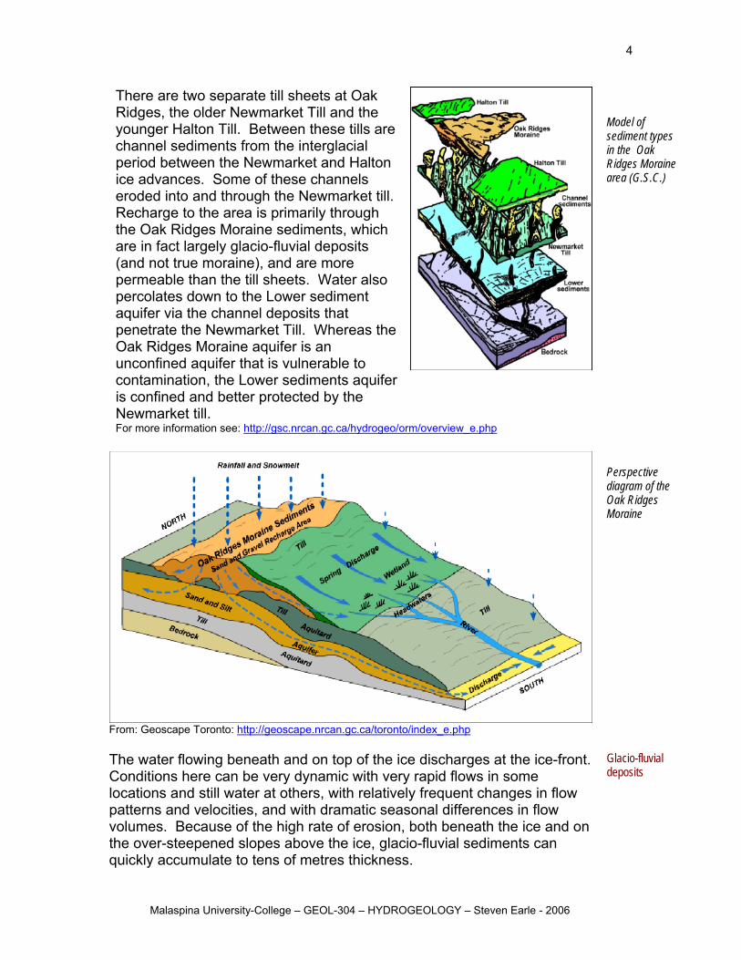
There are two separate till sheets at Oak
e
on
till.
also
as the
le to ifer
Ridges, the older Newmarket Till and the younger Halton Till. Between these tills archannel sediments from the interglacial period between the Newmarket and Haltice advances. Some of these channels eroded into and through the Newmarket Recharge to the area is primarily through the Oak Ridges Moraine sediments, whichare in fact largely glacio-fluvial deposits (and not true moraine), and are more permeable than the till sheets. Water percolates down to the Lower sediment aquifer via the channel deposits that penetrate the Newmarket Till. WhereOak Ridges Moraine aquifer is an unconfined aquifer that is vulnerabcontamination, the Lower sediments aquis confined and better protected by the Newmarket till. For more information see: http://gsc.nrcan.gc.ca/hydrogeo/orm/overview_e.php
Model of
ypes
ine
sediment tin the Oak Ridges Moraarea (G.S.C.)
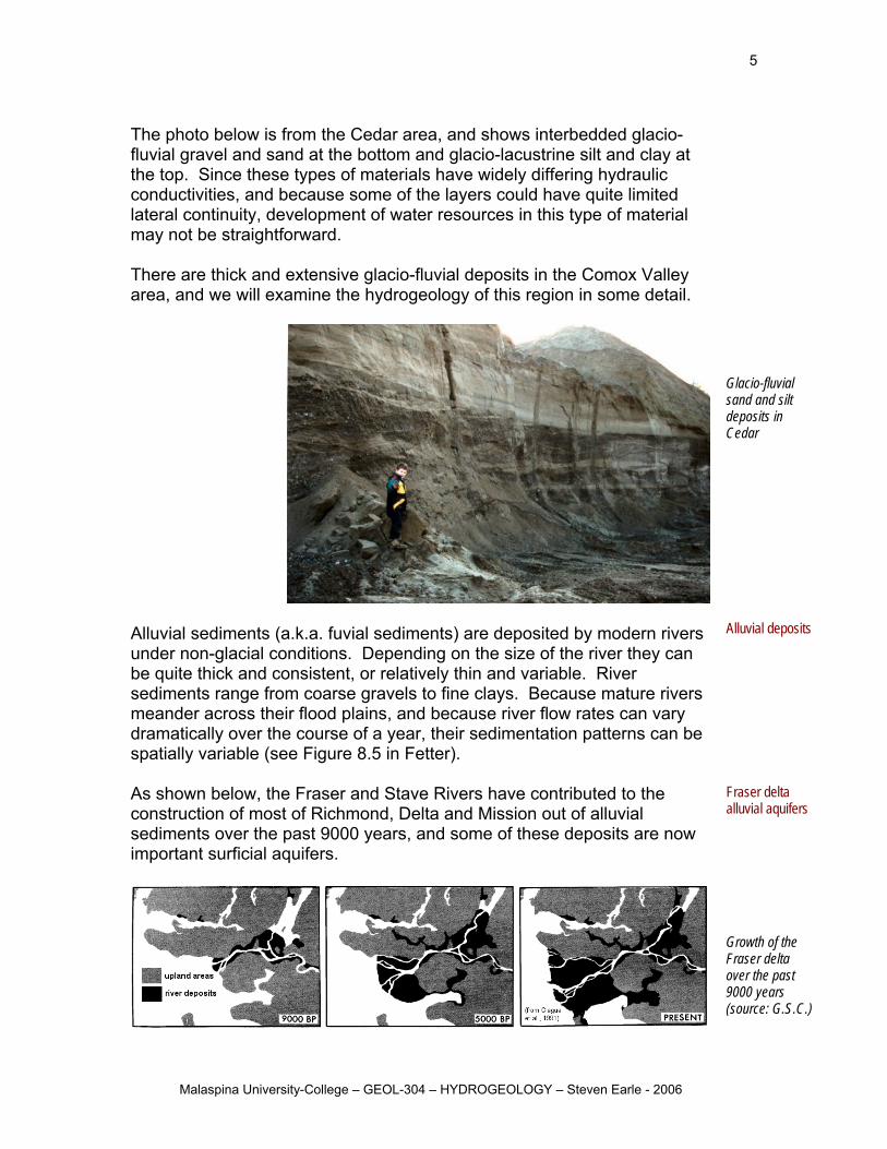
erspective
e
From: Geoscape Toronto: http://geoscape.nrcan.gc.ca/toronto/index_e.php
Pdiagram of thOak Ridges Moraine
he water flowing beneath and on top of the ice discharges at the ice-front.
flow
on
Glacio-fluvial TConditions here can be very dynamic with very rapid flows in some locations and still water at others, with relatively frequent changes inpatterns and velocities, and with dramatic seasonal differences in flow volumes. Because of the high rate of erosion, both beneath the ice andthe over-steepened slopes above the ice, glacio-fluvial sediments can quickly accumulate to tens of metres thickness.
deposits
Malaspina University-College – GEOL-304 – HYDROGEOLOGY – Steven Earle - 2006
5
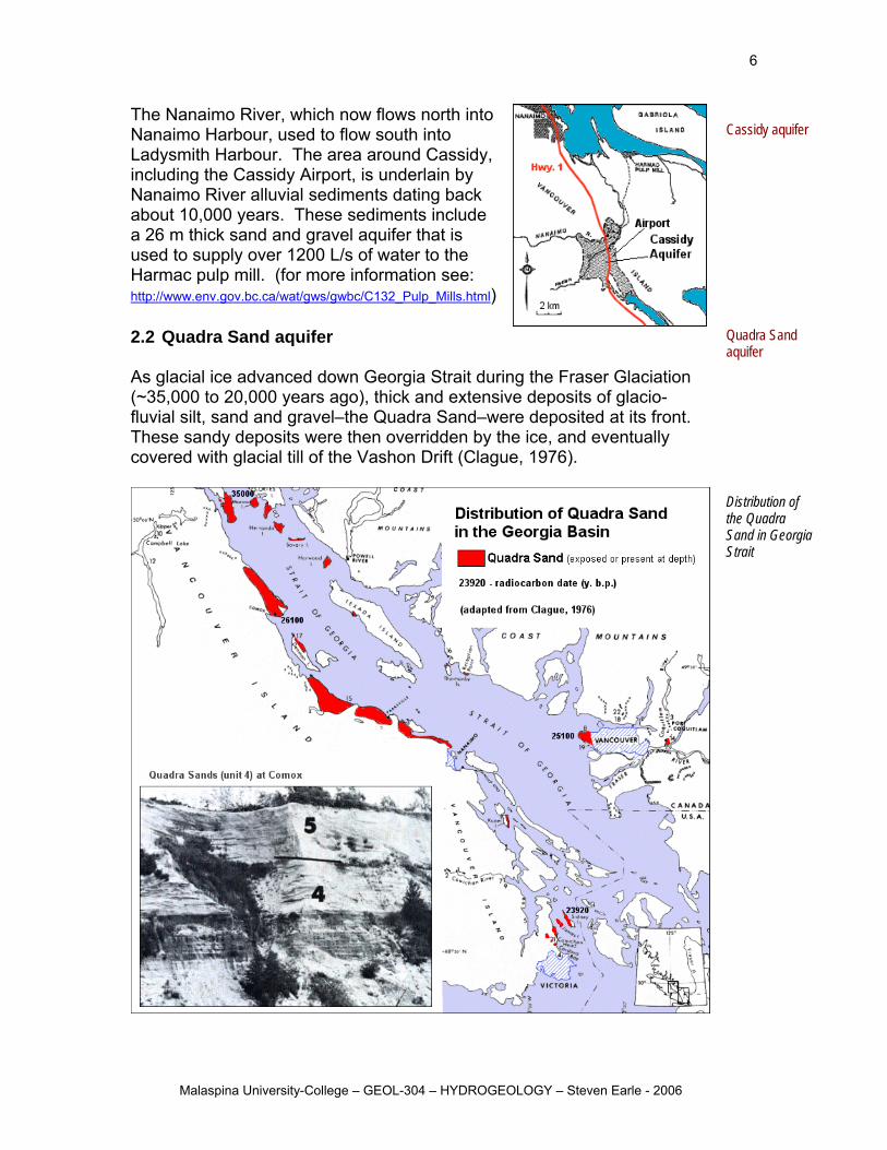
The photo below is from the Cedar area, and shows interbedded glacio-
t
here are thick and extensive glacio-fluvial deposits in the Comox Valley
fluvial gravel and sand at the bottom and glacio-lacustrine silt and clay athe top. Since these types of materials have widely differing hydraulic conductivities, and because some of the layers could have quite limitedlateral continuity, development of water resources in this type of materialmay not be straightforward. Tarea, and we will examine the hydrogeology of this region in some detail.
lacio-fluvial
lluvial sediments (a.k.a. fuvial sediments) are deposited by modern rivers
e rivers
e
lluvial deposits
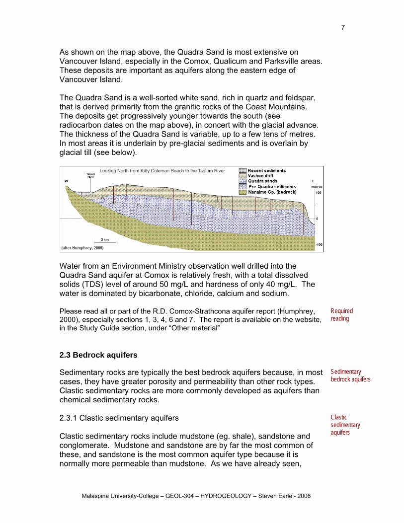
s shown below, the Fraser and Stave Rivers have contributed to the
now
Fraser delta rs
Gsand and silt deposits in Cedar
Aunder non-glacial conditions. Depending on the size of the river they can be quite thick and consistent, or relatively thin and variable. River sediments range from coarse gravels to fine clays. Because maturmeander across their flood plains, and because river flow rates can vary dramatically over the course of a year, their sedimentation patterns can bspatially variable (see Figure 8.5 in Fetter).
A
Aconstruction of most of Richmond, Delta and Mission out of alluvial sediments over the past 9000 years, and some of these deposits areimportant surficial aquifers.
alluvial aquife
Growth of the Fraser delta over the past 9000 years (source: G.S.C.)
Malaspina University-College – GEOL-304 – HYDROGEOLOGY – Steven Earle - 2006
6
The Nanaimo River, which now flows north into Nanaimo Harbour, used to flow south into Ladysmith Harbour. The area around Cassidy, including the Cassidy Airport, is underlain by Nanaimo River alluvial sediments dating back about 10,000 years. These sediments include a 26 m thick sand and gravel aquifer that is used to supply over 1200 L/s of water to the Harmac pulp mill. (for more information see: http://www.env.gov.bc.ca/wat/gws/gwbc/C132_Pulp_Mills.html)
2.2 Quadra Sand aquifer As glacial ice advanced down Georgia Strait(~35,000 to 20,000 years ago), thick and extensive deposits of glacio-fluvial silt, sand and gravel–the Quadra Sand–These sandy deposits were then overridden by th
Cassidy aquifer
duri
were deposited at its front. e ice, and eventually
covered with glacial till of the Vashon Drift (Clague, 1976).
ng the Fraser Glaciation
Quadra Sand aquifer
ion of e Quadra and in Georgia trait
DistributthSS
Malaspina University-College – GEOL-304 – HYDROGEOLOGY – Steven Earle - 2006
7
As shown on the map above, the Quadra Sand is most extensive on Vancouver Island, especially in the Comox, Qualicum and Parksville areas. These deposits are important as aquifers along the eastern edge of Vancouver Island. The Quadra Sand is a well-sorted white sand, rich in quartz and feldspar, that is derived primarily from the granitic rocks of the Coast Mountains. The deposits get progressively younger towards the south (see radiocarbon dates on the map above), in concert with the glacial advance. The thickness of the Quadra Sand is variable, up to a few tens of metres. In most areas it is underlain by pre-glacial sediments and is overlain by glacial till (see below).
Water from an Environment Ministry observation well drilled into the Quadra Sand aquifer at Comox is relatively fresh, with a total dissolved solids (TDS) level of around 50 mg/L and hardness of only 40 mg/L. The
ater is dominated by bicarbonate, chloride, calcium and sodium.
ebsite, ction, under “Other material”
Required reading
n ocks.
Sedimentary bedrock aquifers
2.3.1 Clastic sedimentary aquifers Clastic sedimentary rocks include mudstone (eg. shale), sandstone and conglomerate. Mudstone and sandstone are by far the most common of these, and sandstone is the most common aquifer type because it is normally more permeable than mudstone. As we have already seen,
Clastic sedimentary aquifers
w Please read all or part of the R.D. Comox-Strathcona aquifer report (Humphrey, 2000), especially sections 1, 3, 4, 6 and 7. The report is available on the win the Study Guide se 2.3 Bedrock aquifers Sedimentary rocks are typically the best bedrock aquifers because, in most cases, they have greater porosity and permeability than other rock types. Clastic sedimentary rocks are more commonly developed as aquifers thachemical sedimentary r
Malaspina University-College – GEOL-304 – HYDROGEOLOGY – Steven Earle - 2006
8
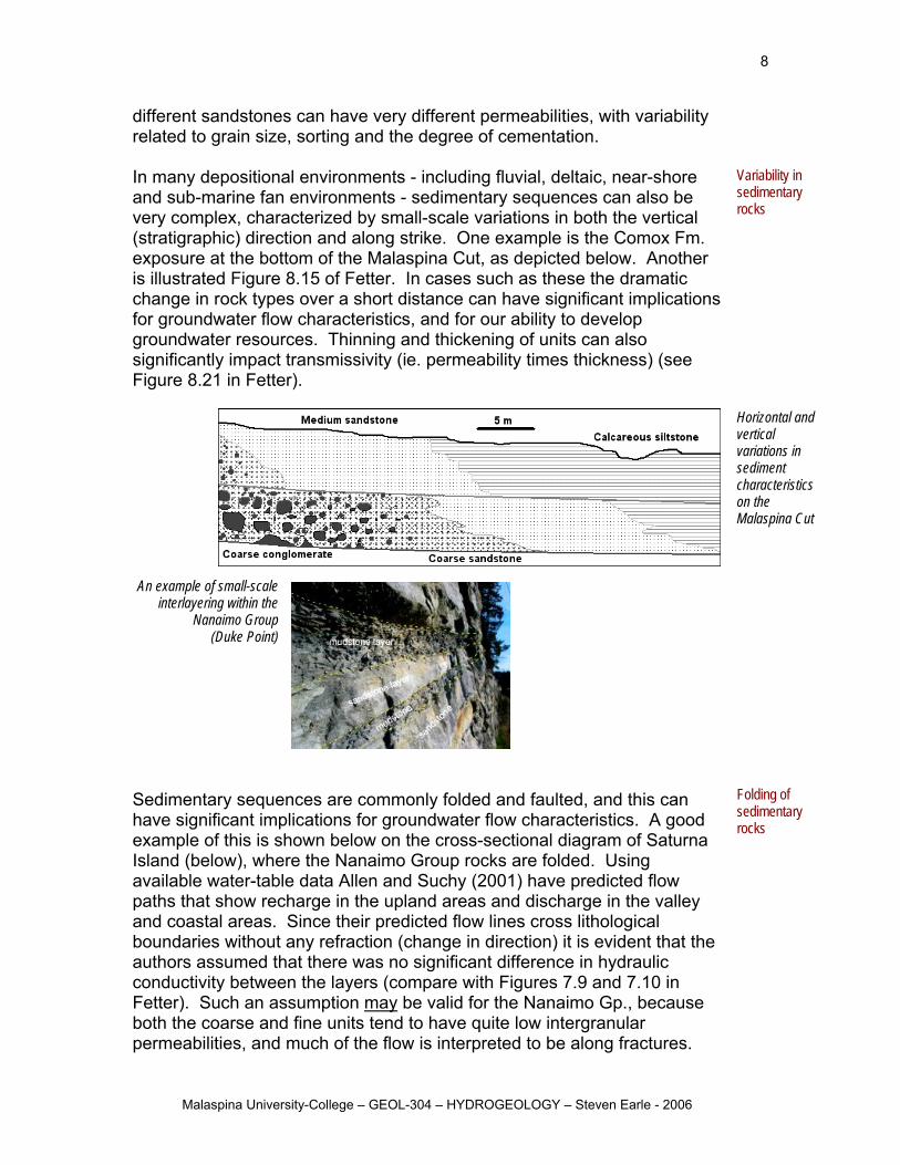
different sandstones can have very different permeabilities, with variability related to grain size, sorting and the degree of cementation. In many depositional environments - including fluvial, deltaic, near-shore and sub-marine fan environments - sedimentary sequences can also be very complex, characterized by small-scale variations in both the vertical (stratigraphic) direction and along strike. One example is the Comox Fm. exposure at the bottom of the Malaspina Cut, as depicted below. Another is illustrated Figure 8.15 of Fetter. In cases such as these the dramatic hange in rock types over a short distance can have significant implications
Variability in sedimentary rocks
c for groundwater flow characteristics, and for our ability to develop groundwater resources. Thinning and thickening of units can also significantly impact transmissivity (ie. permeability times thickness) (see Figure 8.21 in Fetter).
An example of small-scale
interlayering within the Nanaimo Group
(Duke Point)
Horizontal and vertical variations in sediment characteristics on the
alaspina Cut
tics. A good
M
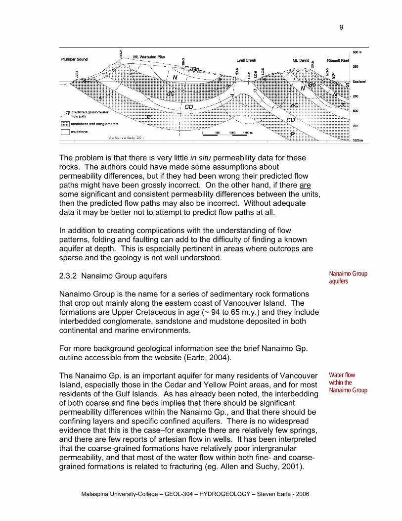
Sedimentary sequences are commonly folded and faulted, and this can ave significant implications for groundwater flow characterish
example of this is shown below on the cross-sectional diagram of SaturnaIsland (below), where the Nanaimo Group rocks are folded. Using available water-table data Allen and Suchy (2001) have predicted flow paths that show recharge in the upland areas and discharge in the valley and coastal areas. Since their predicted flow lines cross lithological boundaries without any refraction (change in direction) it is evident that the authors assumed that there was no significant difference in hydraulic conductivity between the layers (compare with Figures 7.9 and 7.10 in Fetter). Such an assumption may be valid for the Nanaimo Gp., beboth the coarse and fine units tend to have quite low intergranular permeabilities, and much of the flow is interpreted to be along fractures.
cause
Folding of sedimentary rocks
Malaspina University-College – GEOL-304 – HYDROGEOLOGY – Steven Earle - 2006
9
The problem is that there is very l permeability data for these rocks. Th could have made some assumptions about permeability differences, but if they had been wrong their predicted flow paths might have been grossly incorrect. On the other hand, if there are
ittle in situe authors
some significant and consistent permeability differences between the units, then the predicted flow paths may also be incorrect. Without adequate data it may be better not to attempt to predict flow paths at all.
addition to creating complications with the understanding of flow
lude
outline accessible from the website (Earle, 2004).
Nanaimo Group aquifers
The Nanaimo Gp. is an important aquifer for many residents of Vancouver Island, especially those in the Cedar and Yellow Point areas, and for most residents of the Gulf Islands. As has already been noted, the interbedding of both coarse and fine beds implies that there should be significant permeability differences within the Nanaimo Gp., and that there should be confining layers and specific confined aquifers. There is no widespread evidence that this is the case–for example there are relatively few springs, and there are few reports of artesian flow in wells. It has been interpreted
formations have relatively poor intergranular
Water flow within the Nanaimo Group
Inpatterns, folding and faulting can add to the difficulty of finding a known aquifer at depth. This is especially pertinent in areas where outcrops are sparse and the geology is not well understood. 2.3.2 Nanaimo Group aquifers Nanaimo Group is the name for a series of sedimentary rock formations that crop out mainly along the eastern coast of Vancouver Island. The formations are Upper Cretaceous in age (~ 94 to 65 m.y.) and they incinterbedded conglomerate, sandstone and mudstone deposited in both continental and marine environments. For more background geological information see the brief Nanaimo Gp.
that the coarse-grainedpermeability, and that most of the water flow within both fine- and coarse-grained formations is related to fracturing (eg. Allen and Suchy, 2001).
Malaspina University-College – GEOL-304 – HYDROGEOLOGY – Steven Earle - 2006
10
This is supported by the fact that there are many successful wellmudstone formations of the Nanaimo Gp. Although many people depend on the Nanaimo Gp. for their water, there are a number of important issues related to quantity and quality of the supply. One problem is that Gulf Island residents tend to cluste
s within
r near to e shorelines where well-users end up competing for the resource, and
ost rm
matically in the summer, t the same time that water levels are at their lowest.
anaimo Gp. groundwater is generally quite dilute and soft, with average r
ed –such as fluoride, boron and
elenium.
Nanaimo Group water supply and quality
chemistry (Earle and rogh, 2004) and the Ministry of Water Land and Air Protection website on
Required reading
ar
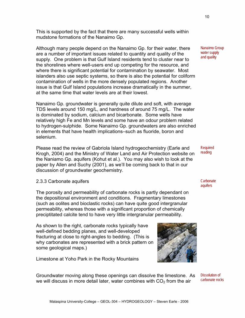
Carbonate aquifers
cally have ell-defined bedding planes, and well-developed
2 from the air
Dissolution of carbonate rocks
thwhere there is significant potential for contamination by seawater. Mislanders also use septic systems, so there is also the potential for colifocontamination of wells in the more densely populated regions. Another issue is that Gulf Island populations increase draa NTDS levels around 150 mg/L, and hardness of around 75 mg/L. The wateis dominated by sodium, calcium and bicarbonate. Some wells have relatively high Fe and Mn levels and some have an odour problem related to hydrogen-sulphide. Some Nanaimo Gp. groundwaters are also enrichin elements that have health implicationss Please read the review of Gabriola Island hydrogeoKthe Naniamo Gp. aquifers (Kohut et al.). You may also wish to look at the paper by Allen and Suchy (2001), as we’ll be coming back to that in our discussion of groundwater geochemistry. 2.3.3 Carbonate aquifers The porosity and permeability of carbonate rocks is partly dependant on the depositional environment and conditions. Fragmentary limestones (such as oolites and bioclastic rocks) can have quite good intergranulpermeability, whereas those with a significant proportion of chemically preciptitated calcite tend to have very little intergranular permeability. As shown to the right, carbonate rocks typiwfracturing at close to right-angles to bedding. (This is why carbonates are represented with a brick pattern on some geological maps.) Limestone at Yoho Park in the Rocky Mountains Groundwater moving along these openings can dissolve the limestone. Aswe will discuss in more detail later, water combines with CO
Malaspina University-College – GEOL-304 – HYDROGEOLOGY – Steven Earle - 2006
11
and the soil to form carbonic acid (H2CO3), which will promote dissolution
f
from O2 it will soon become saturated with respect to calcite, and
issolution will stop.
o
ssolution is relatively limited, flow within a arbonate aquifer can be diffuse, like that in a typical sandstone aquifer. e flow
re
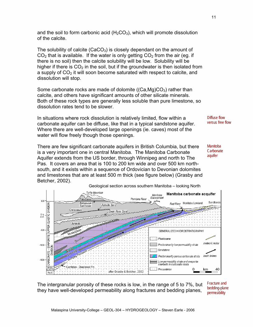
quifer extends from the US border, through Winnipeg and north to The o
n to Devonian dolomites below) (Grasby and
gical section across southern Manitoba – looking North
Manitoba Carbonate aquifer
of the calcite. The solubility of calcite (CaCO3) is closely dependant on the amount oCO2 that is available. If the water is only getting CO2 from the air (eg. if there is no soil) then the calcite solubility will be low. Solubility will be higher if there is CO2 in the soil, but if the groundwater is then isolated a supply of Cd Some carbonate rocks are made of dolomite ((Ca,Mg)CO3) rather than calcite, and others have significant amounts of other silicate minerals. Both of these rock types are generally less soluble than pure limestone, sdissolution rates tend to be slower. In situations where rock dicWhere there are well-developed large openings (ie. caves) most of the water will flow freely though those openings. There are few significant carbonate aquifers in British Columbia, but theis a very important one in central Manitoba. The Manitoba Carbonate
Diffuse flow versus fre
APas. It covers an area that is 100 to 200 km wide andsouth, and it exists within a sequence of Ordoviciaand limestones that are at least 500 m thick (see figureBetcher, 2002).
Geolo
ver 500 km north-
The intergranular porosity of these rocks is low, in the range of 5 to 7%, they have well-developed permeability along fractures and bedding plan
but es,
Fracture and bedding-plane permeability
Malaspina University-College – GEOL-304 – HYDROGEOLOGY – Steven Earle - 2006
12
especially in the upper 10 m. Permeability has been enhanced by dissolution. Local recharge is restricted by a consistent veneer of glacial till and glaciolacustrine sediments, but there is recharge from areas where the overburden is sandy (e.g., in the Sandilands area). The rocks of this aquifer are part of a very extensive sequence of
,
arrows on diagram above) can be extremely salty. These brines have total dissolved solids (TDS) concentrations up to 320,000 mg/L (320 g/L!), which is almost 10 times that of sea water (~35,000 mg/L). They are dominated by Na and Cl, and are not used as a water source.
Deep-flow
the
The fresh water that enters the aquifer in Manitoba flows generally from east to west (yellow arrow). It reacts with the calcite and dolomite bearing carbonate rocks and becomes relatively rich in calcium, magnesium and bicarbonate. The average concentrations (all in mg/L) are: Ca-62, Mg-56, Na-53, Cl-46, SO4-88 and HCO3-415. The average hardness (Ca plus Mg expressed as CaCO3) is nearly 400 mg/L, which is an issue for many water users, since hardness of 100 mg/L is considered significant. Most people who use this water have to use water softeners. (The average hardness of Nanaimo Gp. water is about 75 mg/L.)
Local recharge of fresh water Significant Ca & Mg hardness
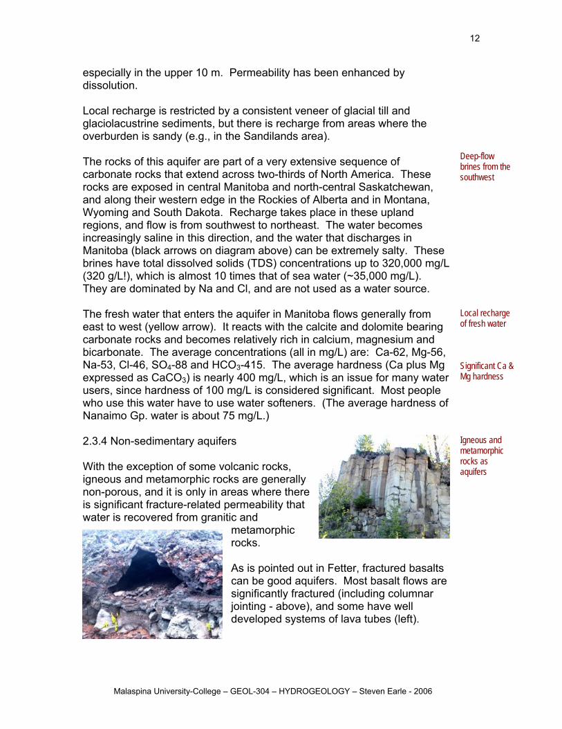
2.3.4 Non-sedimentary aquifers
ith the exception of some volcanic rocks,
metamorphic
tter, fractured basalts
mnar
Igneous and metamorphic ocks as
carbonate rocks that extend across two-thirds of North America. These rocks are exposed in central Manitoba and north-central Saskatchewanand along their western edge in the Rockies of Alberta and in Montana, Wyoming and South Dakota. Recharge takes place in these upland regions, and flow is from southwest to northeast. The water becomes increasingly saline in this direction, and the water that discharges in Manitoba (black
brines fromsouthwest
Wigneous and metamorphic rocks are generally non-porous, and it is only in areas where there is significant fracture-related permeability that water is recovered from granitic and
rocks. As is pointed out in Fecan be good aquifers. Most basalt flows are significantly fractured (including colujointing - above), and some have well developed systems of lava tubes (left).
raquifers
Malaspina University-College – GEOL-304 – HYDROGEOLOGY – Steven Earle - 2006
13
References (Go to the “Other material” link on the Study Guide page for links todocuments.) Allen, D and Suchy, M, Geochemical evolution of groundwater on Saturna Island, BColumbia, Can. Jour. Earth Sci, 38, pp.1059 1080, 2001.
most of these
ritish
gy,
e
p.
gional hydroquifer, southern Manitoba, Can. Jour. Earth Sci., V. 39, p. 1053-1063
thcona aquifer classification pro
water Resources of British Columbia,
Betcher, R, Grove, G and Pupp, C, 1995, Groundwater in Manitoba: hydrogeoloquality concerns, management, NHRI contribution CS-93017. Clague J, 1976, Quadra Sand and its relation to the late Wisconsin glaciation of southwest British Columbia, Can. Jour. Earth Sci., V. 13, p. 803-815. (available in thlibrary) Earle, S., The Nanaimo Group Earle, S and Krogh, E., 2004, Groundwater geochemistry of Gabriola, Shale, No. 7,37-44. Grasby, S and Betcher, R, 2002, Re geochemistry of the carbonate rock a Humphrey G, 2000, Regional District of Comox-Strareport Kohut, A, Foweraker, J and Hodge, W, Ground9.13 Gulf Islands,
ject
Malaspina University-College – GEOL-304 – HYDROGEOLOGY – Steven Earle - 2006