Embed Size (px)
Citation preview
October 6, 2014
1755-1850 MHz
NOTE: In March 2014, the Federal Communications Commission (FCC) in
collaboration with NTIA reallocated the 1755-1780 MHz portion of the 1755-1850 MHz
band to commercial wireless use. In November 2014, the FCC is scheduled to commence
competitive bidding for new licenses in the 1755-1780 MHz band for Advanced Wireless
Services (AWS-3). Most of the federal systems now operating in the 1755-1780 MHz
will relocate to another band or will compress operations into the 1780-1850 MHz
portion of the band. The FCC’s rules also provide for indefinite sharing between AWS-3
licenses and a limited number of federal systems. Once the relocation of federal systems
from the 1755-1780 MHz band is in progress, this 1755-1780 MHz spectrum inventory
report will be updated and reported separately as the 1755-1780 MHz band and 1780-
1850 MHz band. Further information about the planned transition of systems in support
of the AWS-3 auction can be found at http://www.ntia.doc.gov/category/aws-3-transition.
1. Band Introduction
Operations in the 1755-1850 MHz band consist of military tactical radio relay, air combat
training systems, tracking, telemetry, and control data communications for control of
spacecraft. Federal agencies and the military also use this band for law enforcement video
surveillance and robotics, terrestrial telemetering operations for aircraft, missile flight
testing, fixed point-to-point microwave relay communications and unmanned aerial
systems. This band is currently under review as a candidate for accommodating wireless
broadband.
1755 – 1850 MHz
Page 2 of 25
2. Allocations
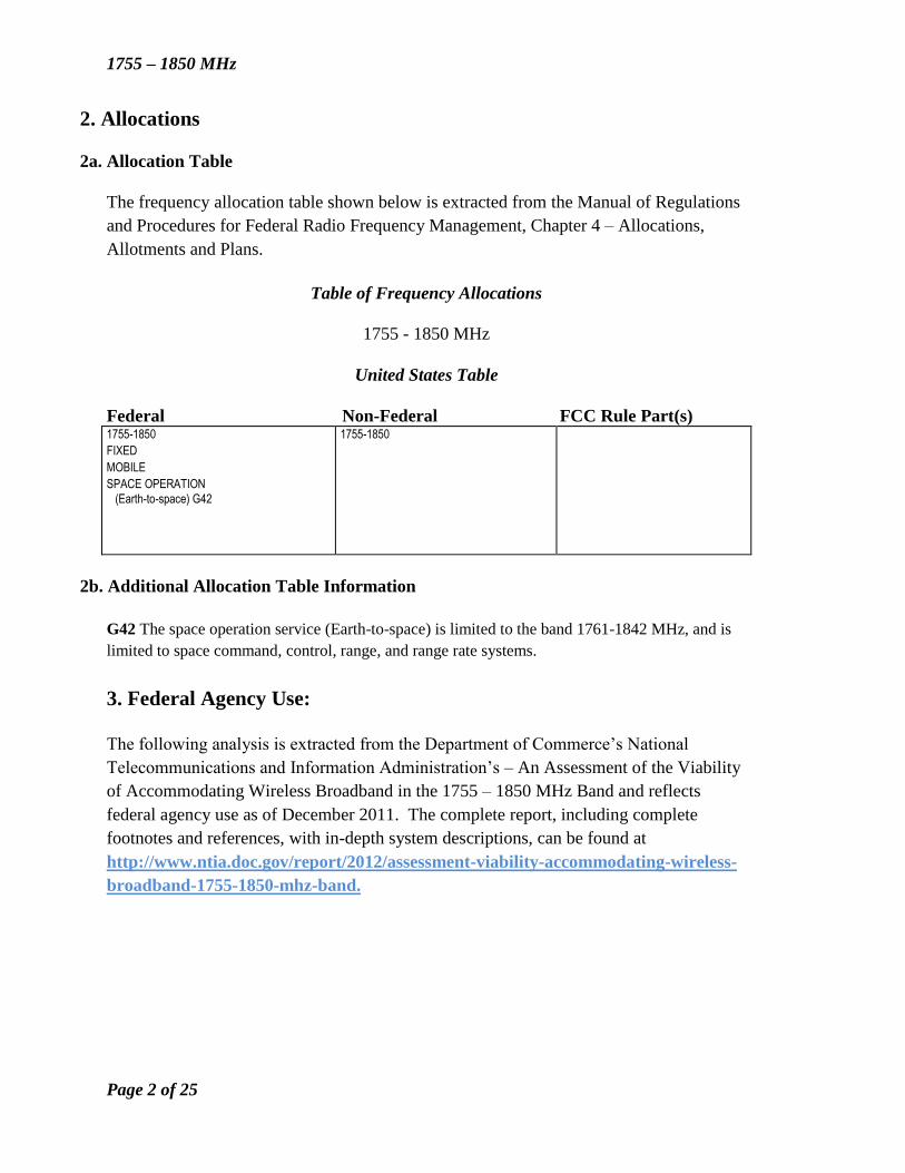
2a. Allocation Table
The frequency allocation table shown below is extracted from the Manual of Regulations
and Procedures for Federal Radio Frequency Management, Chapter 4 – Allocations,
Allotments and Plans.
Table of Frequency Allocations
1755 - 1850 MHz
United States Table
Federal Non-Federal FCC Rule Part(s) 1755-1850
FIXED
MOBILE
SPACE OPERATION
(Earth-to-space) G42
1755-1850
2b. Additional Allocation Table Information
G42 The space operation service (Earth-to-space) is limited to the band 1761-1842 MHz, and is
limited to space command, control, range, and range rate systems.
3. Federal Agency Use:
The following analysis is extracted from the Department of Commerce’s National
Telecommunications and Information Administration’s – An Assessment of the Viability
of Accommodating Wireless Broadband in the 1755 – 1850 MHz Band and reflects
federal agency use as of December 2011. The complete report, including complete
footnotes and references, with in-depth system descriptions, can be found at
http://www.ntia.doc.gov/report/2012/assessment-viability-accommodating-wireless-
broadband-1755-1850-mhz-band.
1755 – 1850 MHz
Page 3 of 25
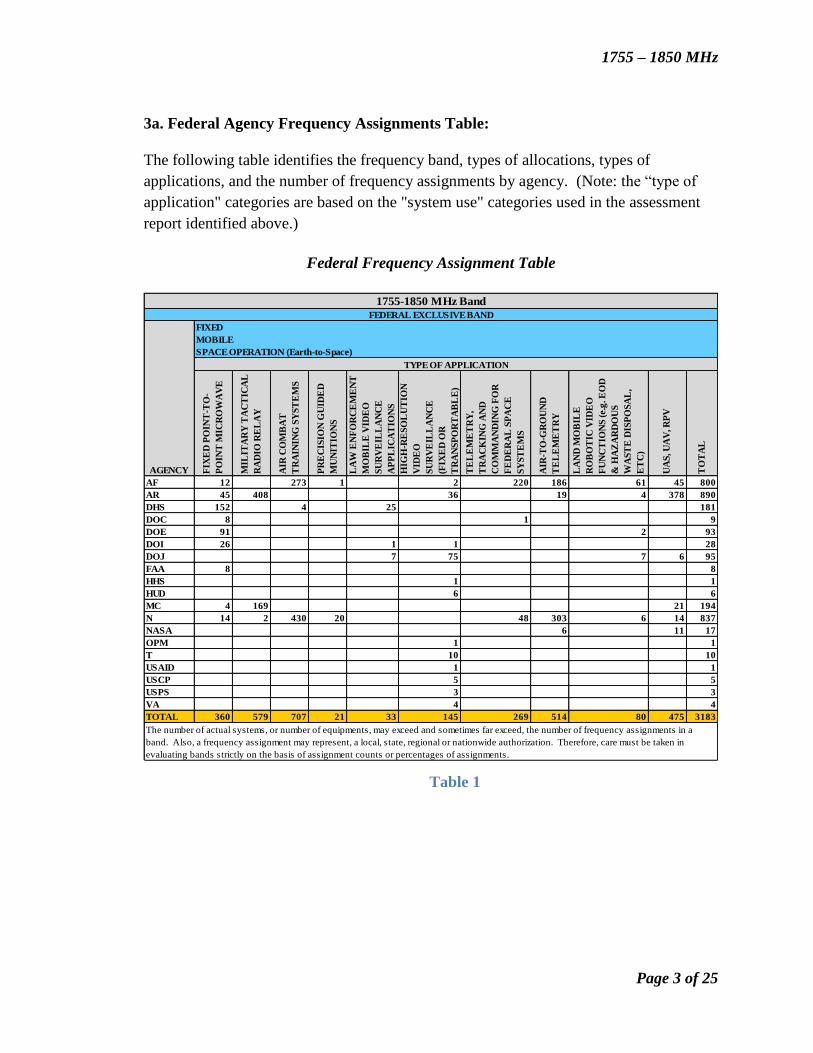
3a. Federal Agency Frequency Assignments Table:
The following table identifies the frequency band, types of allocations, types of
applications, and the number of frequency assignments by agency. (Note: the “type of
application" categories are based on the "system use" categories used in the assessment
report identified above.)
Federal Frequency Assignment Table
Table 1
FIX
ED
PO
INT
-TO
-
PO
INT
MIC
RO
WA
VE
MIL
ITA
RY
TA
CT
ICA
L
RA
DIO
RE
LA
Y
AIR
CO
MB
AT
TR
AIN
ING
SY
ST
EM
S
PR
EC
ISIO
N G
UID
ED
MU
NIT
ION
S
LA
W E
NF
OR
CE
ME
NT
MO
BIL
E V
IDE
O
SU
RV
EIL
LA
NC
E
AP
PL
ICA
TIO
NS
HIG
H-R
ES
OL
UT
ION
VID
EO
SU
RV
EIL
LA
NC
E
(FIX
ED
OR
TR
AN
SP
OR
TA
BL
E)
TE
LE
ME
TR
Y,
TR
AC
KIN
G A
ND
CO
MM
AN
DIN
G F
OR
FE
DE
RA
L S
PA
CE
SY
ST
EM
S
AIR
-TO
-GR
OU
ND
TE
LE
ME
TR
Y
LA
ND
MO
BIL
E
RO
BO
TIC
VID
EO
FU
NC
TIO
NS
(e.
g. E
OD
& H
AZ
AR
DO
US
WA
ST
E D
ISP
OS
AL
,
ET
C)
UA
S, U
AV
, RP
V
TO
TA
L
AF 12 273 1 2 220 186 61 45 800
AR 45 408 36 19 4 378 890
DHS 152 4 25 181
DOC 8 1 9
DOE 91 2 93
DOI 26 1 1 28
DOJ 7 75 7 6 95
FAA 8 8
HHS 1 1
HUD 6 6
MC 4 169 21 194
N 14 2 430 20 48 303 6 14 837
NASA 6 11 17
OPM 1 1
T 10 10
USAID 1 1
USCP 5 5
USPS 3 3
VA 4 4
TOTAL 360 579 707 21 33 145 269 514 80 475 3183
The number of actual systems, or number of equipments, may exceed and sometimes far exceed, the number of frequency assignments in a
band. Also, a frequency assignment may represent, a local, state, regional or nationwide authorization. Therefore, care must be taken in
evaluating bands strictly on the basis of assignment counts or percentages of assignments.
1755-1850 MHz Band
FEDERAL EXCLUSIVE BAND
AGENCY
FIXED
SPACE OPERATION (Earth-to-Space)
TYPE OF APPLICATION
MOBILE
1755 – 1850 MHz
Page 4 of 25
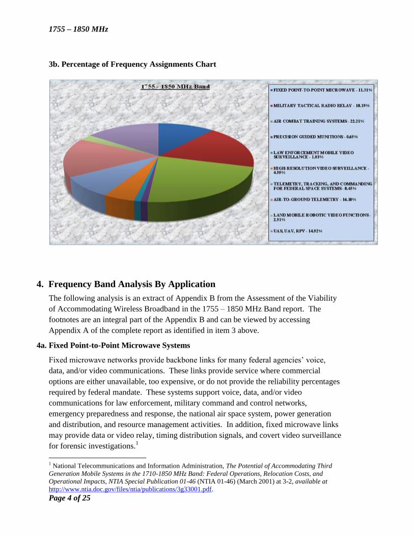
3b. Percentage of Frequency Assignments Chart
4. Frequency Band Analysis By Application
The following analysis is an extract of Appendix B from the Assessment of the Viability
of Accommodating Wireless Broadband in the 1755 – 1850 MHz Band report. The
footnotes are an integral part of the Appendix B and can be viewed by accessing
Appendix A of the complete report as identified in item 3 above.
4a. Fixed Point-to-Point Microwave Systems
Fixed microwave networks provide backbone links for many federal agencies’ voice,
data, and/or video communications. These links provide service where commercial
options are either unavailable, too expensive, or do not provide the reliability percentages
required by federal mandate. These systems support voice, data, and/or video
communications for law enforcement, military command and control networks,
emergency preparedness and response, the national air space system, power generation
and distribution, and resource management activities. In addition, fixed microwave links
may provide data or video relay, timing distribution signals, and covert video surveillance
for forensic investigations.1
1 National Telecommunications and Information Administration, The Potential of Accommodating Third
Generation Mobile Systems in the 1710-1850 MHz Band: Federal Operations, Relocation Costs, and
Operational Impacts, NTIA Special Publication 01-46 (NTIA 01-46) (March 2001) at 3-2, available at
http://www.ntia.doc.gov/files/ntia/publications/3g33001.pdf.
1755 – 1850 MHz
Page 5 of 25
The DOD uses fixed microwave relay systems in the band on military installations and
test and training ranges for a variety of functions. These functions include providing
general-purpose communications to remote areas; relaying radar data from remote ranges
to control centers; transmitting video data from bombing and gunnery ranges; supporting
command and control networks; and sending control data to tethered aerostat balloons,
radar data from the tethered aerostat balloons to the ground control stations, and power
grid and hydroelectric data.2
The Air Force uses the band for the ground infrastructure of the Air Combat Training
Systems. The non-ACTS frequency assignments for the Air Force fixed point-to-point
systems are associated either with local range instrumentation and data retrieval or with
installation security.
The Army operates long-haul communications links and air traffic control links at
airfields in the CONUS.
The Army Corps of Engineers uses this band for its fixed microwave radio systems
providing backbone communications for the engineering districts in the continental
United States. The Corps also uses this frequency band for various purposes such as
operating remotely-controlled hydro-electric generating stations, communications support
for emergency civilian relief, flood control and sensor telemetry, temporary
communications in each district, and maintenance and traffic control of approximately
48,000 kilometers of inland waterways, including harbors, locks, and dams. The fixed
microwave communications systems ensure the safety and integrity of the nation’s
waterways, help prevent catastrophes, and provide emergency civilian relief.3
The Navy operates fixed microwave radio systems in this frequency band at certain
facilities to provide infrastructure connectivity. These systems support both one-way and
two-way communications, depending on connectivity requirements. These fixed
microwave radio systems provide cost-effective and reliable solutions for isolated
facilities in remote areas.
The Department of Commerce’s National Weather Service relays valuable
meteorological data to a variety of users, including the public.
DHS uses this band to support security enforcement along the United States’
Texas/Mexican Border. Several point-to-point microwave systems provide a critical link
for the various communications and surveillance technologies used by DHS field
personnel. These wireless systems route communications media, voice from tactical
radios, video imagery from remote video surveillance systems, and data from ground
sensors to the key decision makers in central command and communications centers. The
2 DOD-2 at § 4.2.
3 DOD Strategic Spectrum Plan, supra note 30, at 3-2.
1755 – 1850 MHz
Page 6 of 25
systems operate on a continuous basis and provide itinerant video imaging and critical
border operations information to the border patrol and law enforcement.4
The Department of the Interior system supports relaying seismic monitoring data. The
seismic monitors collect and disseminate near real-time data used for emergency
response to significant earthquakes, tsunami warning, detection of volcanic unrest, and
public information.5
The FAA uses fixed links to interconnect the nation’s air traffic control facilities in
support of aviation safety. FAA radar and air–to-ground radio facilities are frequently
located in remote mountain areas to facilitate clear communications with commercial and
military aircraft. These locations usually lack commercial communications access and
require the FAA to use microwave radio systems.6
DOE uses this band for a wide-area network to supervise, control, and protect electric
power transmission systems.7 The system connects federal power marketing control
facilities in the western half of the United States. The system can interconnect with the
private sector for critical communications dealing with generating and distributing power.
This critical infrastructure operates 24 hours a day/seven days a week. The microwave
systems allow power system dispatchers to monitor the health and the amount of load on
the energy grid, to be able to add or drop load, and to monitor generation. These
microwave systems also allow protective relay and remedial action schemes to operate in
order to prevent phase or ground faults from taking down the power grid, as well as
preventing damage to power substation equipment and loss of life. This entire system
works to ensure the western United States does not lose power. In addition, the
microwave system also carries the very high frequency (VHF) land mobile radio system
channels. The VHF mobile systems allow maintenance personnel to perform
maintenance of the energy grid at Fort Chaffe and Pinnacle Peak in Arizona.8
4b. Military Tactical Radio Relay Systems
The DOD operates tactical communications systems in the band that provide mid/high
capacity digital information to the battlefield commanders. Tactical radio relay is a
transportable fixed microwave system often deployed to multiple locations to interoperate
4 DHS-1 at 8.
5 DOI-1 at 6.
6 FAA-1 at 1.
7 National Telecommunications and Information Administration, Federal Operations in the 1755-1780
MHz Band: The Potential for Accommodating Third Generation Mobile Systems Interim Report (NTIA
2000 Interim Report) (Nov. 15, 2000) at 23, available at
http://www.ntia.doc.gov/files/ntia/publications/imt2000.pdf. 8 DOE-2 at 14.
1755 – 1850 MHz
Page 7 of 25
with other systems for training exercises or operational missions.9 DOD uses TRRs for
the command and control of forces and high-capacity digital information to the
battlefield.10
There are two TRR systems within the DOD. One is the Army’s HCLOS and the second
is the Navy and Marine Corps’ DWTS. These tactical systems quickly establish
microwave links in support of combat operations and maneuver warfare. TRRs provide
the DOD with transportable base stations and the capability of backhaul high-capacity
voice and data communications.11
The HCLOS radio (AN/GRC-245) is a multi-band, multi-mode, software-defined radio
that allows the operating frequency and waveform to be selected in real-time to meet
operational requirements of the digital battlefield. The HCLOS radio is a primary
component of the Warfighter Information Network-Tactical (WIN-T) Increment-1.
WIN-T includes network management tools, radios, routers and small, vehicle-mounted
satellite dishes able to transmit signals via terrestrial and satellite from the company level
up to division echelons. It also supports communication connectivity to vehicles on the
move, to other command posts, and higher headquarters. The WIN-T Increment 2 will
support the purchasing and fielding of 20 brigade-sized maneuver units.12
The HCLOS provides the Army with wide area communications for Army tactical
deployments at the battalion, brigade, and division levels. The Army uses these systems
for high-throughput data communications from command and control traffic to
intelligence imagery, logistics, medical, and morale and welfare support. In addition, the
Army’s TRR systems deploy up to 30-50 km apart. These systems provide a digital
microwave backbone to link mid-level and lower-level battlefield commanders. The
TRR system operates like a high-capacity cellular telephone system with highly
transportable base stations. The ability to set up, establish a link to higher headquarters
and subordinate units, and then take down the link and move it to a new location is key to
the survivability of the headquarters’ units and supports the concept of maneuver warfare.
Soldiers require frequent field training to ensure that they can quickly establish a network
of tactical microwave links.13
Navy and Marine Corps Digital Wideband Transmission System
9 A “transportable station” is a station, which is transferred to various fixed locations, but is not intended to
be used while in motion. National Telecommunications and Information Administration, U.S. Department
of Commerce, Manual of Regulations and Procedures for Federal Radio Frequency Management (May
2010 Revision of the January 2008 Edition) (NTIA Manual) at § 6.1.1.
10
NTIA 2000 Interim Report, supra note 7, at 24. 11
DOD Strategic Spectrum Plan, supra note 30, at 38. 12
DOD-2 at § D.1. 13
Id. at § 4.3.1.
1755 – 1850 MHz
Page 8 of 25
The Navy and Marine Corps DWTS provides a backbone digital communications
capability supporting amphibious and ground combat operations. DWTS is used by the
U.S. Joint Forces Command to support the Joint Task Force-Civil Support (JTF-CS) in
the event of a weapon of mass destruction incident.14
The mission of the JTF-CS is to
provide support to a designated lead federal agency in the conduct of consequence
management operations in response to a chemical, biological, radiological, nuclear, and
high yield explosives incident or accident in the United States. Additionally, the Navy
and Marine Corps use DWTS for other contingency operations within the United States
to include disaster relief, national emergencies, and other DOD support requirements to
civil authorities, as directed from the National Command Authority.15
The DWTS
supports command, control, and data transfer from the Marine Expeditionary Force level
down to the regimental level. The Marine Corps DWTS provides digital backbone
services (voice, video, and data) for shore-to-shore and/or ship-to-shore communications
links. This is the Marine Corps’ radio system with sufficient bandwidth to carry large
quantities of critical data such as maps, overlays, intelligence pictures, and other data to
the battlefield commanders. The Navy has a ship-to-shore version of DWTS that is a
LOS radio system used for communications between Expeditionary Strike Group ships
and Marine Corps units ashore, where most of the critical information flow is from the
ship to the landing. The Navy’s shipboard DWTS tunes in the band 1350-1850 MHz
4c. Air Combat Training Systems
Current air combat training involves live air-to-air encounters and may include a network
of ground stations monitoring the training activity. ACTS incorporates fixed and
aeronautical mobile components. The aircraft relays flight parameter data to ground
stations and the ground stations send information to the aircraft. In some cases, training
and related ACTS data and communications involve only interaction between the aircraft,
without the ground links. Training staff, subsequently, retrieve the recorded data for use
in training debriefings. The Tactical Combat Training System/P5 Combat Training
System is a cooperative program between the Navy (TCTS) and Air Force (P5 CTS) to
procure a single instrumented tactical aircrew training capability. This system is
replacing the Air Force’s Aircrew Combat Maneuvering and Instrumentation system and
the Navy and Marine Corps Tactical Aircrew Combat Training System. The TCTS/P5
CTS supports training aircrews using realistic warfighting scenarios. It is the primary
tool at virtually all air combat training ranges and supports every level of training from
initial schools where pilots first learn to fly the aircraft they will take into battle to
advanced-tactics training schools that hone combat skills. The system provides real-time
monitoring, tracking, and recording of training activities, which includes post-mission
14
Department of Defense, Investigation of the Feasibility of Accommodating the International Mobile
Telecommunications (IMT) 2000 Within the 1755-1850 MHz Band (DOD IMT 2000 Assessment)(Feb. 9,
2001) at C-3, available at http://www.ntia.doc.gov/files/ntia/publications/dodassessment.pdf. 15
DOD Strategic Spectrum Plan, supra note 30, at 38.
1755 – 1850 MHz
Page 9 of 25
reconstruction capabilities for pilots to receive accurate debriefing and critiques.16
Allied
Forces ensure cooperative capabilities by conducting joint training sorties. This joint
training occurs inside and outside of the United States.17
The DOD uses the air combat training and tactical combat training systems for daily
proficiency training and as the final readiness training prior to deployment to combat
areas around the world. ACTS and TCTS provide, during exercises and training, real-
time monitoring of aircraft combat operations and maneuvering, such as gun-scoring, no-
drop bombing training, evasion and intercept tactics, and electronic warfare. Most
systems are composed of the ground-based tactical instrumentation subsystem (ground-
to-air) and the aircraft instrumentation subsystem (air-to-ground) mounted internally or
via a pod on the aircraft. The two-way data link between these two subsystems is the
only means by which they interact and allow the overall system to function.
The air-to-air frequencies must be separated by at least 11 megahertz and adjacent range
facilities must be separated by at least five megahertz. Operating altitudes may be as
high as 60,000 feet, with normal operations occurring up to 40,000 feet.
ACTS and TCTS support every level of training a pilot receives from first learning to fly
to advanced tactics. They operate at all test and training ranges, as well as at other bases,
including Reserve and National Guard locations that may include civilian airports.18
U.S.
Allied Forces use identical frequencies and the same equipment.
The P5 Combat Training System is the principal Air Force Air Combat Training System
in use today. Additional P5 CTS capabilities include real-time monitoring and control of
aircraft during large and joint force, and small unit training, while being able to record
events for post-mission debrief and analysis.
The P5 CTS also includes ground system integration, location specific architecture,
internal pod replacement subsystems, and integration of new operational flight programs.
Mission lengths and frequencies may vary from facility to facility depending on the using
unit and the training mission underway. Additional factors affecting mission length and
frequency include local quiet hour regulations, airspace agreements with the FAA, and
overall range operations. There are operational areas in the US&P that include Air Force,
Navy, and Marine Corps usage.19
The Air Force P5 CTS units operate on discrete
frequencies in the 1755-1850 MHz band at Air Force training facilities.
16
DOD Strategic Spectrum Plan, supra note 30, at 38. 17
DOD-2 at § 4.5. 18
NTIA 2000 Interim Report, supra note 7, at 25. 19
DOD-2 at § E.3.
1755 – 1850 MHz
Page 10 of 25
The Navy and Marine Corp’s TCTS consists of various types of Participant Subsystems
(PS). The PS includes Airborne Subsystem pods and Internal Subsystems carried
onboard or inside numerous Navy, Marine Corps, and Air Force fixed wing and rotary
platforms, as well as various Ground Subsystem components designed to receive this
information via RF communication and to interface with other training range system
infrastructure, such as the electronic warfare server system. TCTS merges all of this
information into one comprehensive real-time operating picture and includes post mission
reconstruction capabilities so that crews can receive accurate debriefing and critique of
their mission, thereby maximizing the benefit of the training activities.20
TCTS was designed to operate in two modes. In the live monitor mode, communication
is received by remote range units located throughout the range ground system
infrastructure and passed to a fixed ground system for recording and display. In the
rangeless or autonomous mode, the airborne participants transmit aircraft and weapons
information via communication amongst themselves and data collected is recorded to a
data recording device, and then downloaded post-flight. This rangeless capability makes
system operation and emission possible worldwide.21
The Navy TCTS operates on
discrete frequencies in the band.
4d. Precision Guided Munitions
PGMs operate in this band to communicate between a launched weapon and a controlling
platform, allowing for precise targeting. PGMs provide the capability to attack single
military targets with one aircraft or one standoff weapon with greater probability of
success than by flying waves of aircraft dropping conventional, unguided bombs. PGMs
increase aircrew survivability by allowing the launch of weapons outside of enemy’s anti-
air system threat envelope, thereby significantly decreasing aircrew vulnerability. The
Air Force and the Navy both use PGMs that carry television cameras or infrared sensors,
and GPS receivers, which provide operators the ability to attack targets in all weather
conditions, day or night. Weapon operators require access to a video and a command
link frequency throughout the mission; including ground, pre-launch, post take-off, and
post-launch weapon flight operations. Training operations require use of the frequencies
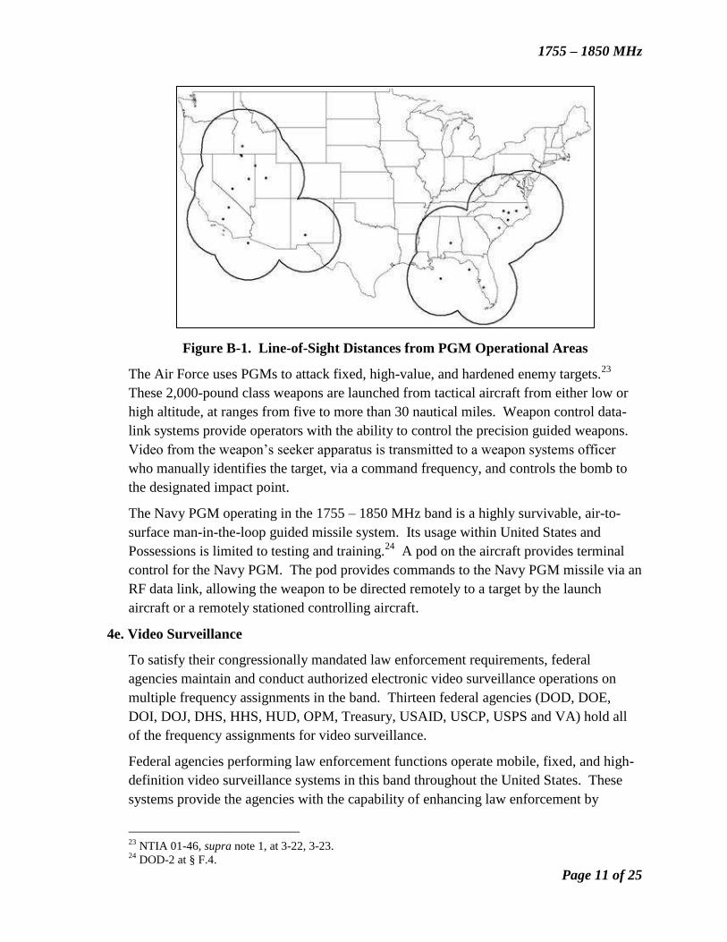
for two hours at a time.22
Figure B-1 provides a map of the contours of nominal radio
line-of-sight distances surrounding many of the operational training areas for PGMs
within the United States.
20
DOD-2 at § F.3. 21
Id. 22
Id. at § F.4.
1755 – 1850 MHz
Page 11 of 25
Figure B-1. Line-of-Sight Distances from PGM Operational Areas
The Air Force uses PGMs to attack fixed, high-value, and hardened enemy targets.23
These 2,000-pound class weapons are launched from tactical aircraft from either low or
high altitude, at ranges from five to more than 30 nautical miles. Weapon control data-
link systems provide operators with the ability to control the precision guided weapons.
Video from the weapon’s seeker apparatus is transmitted to a weapon systems officer
who manually identifies the target, via a command frequency, and controls the bomb to
the designated impact point.
The Navy PGM operating in the 1755 – 1850 MHz band is a highly survivable, air-to-
surface man-in-the-loop guided missile system. Its usage within United States and
Possessions is limited to testing and training.24
A pod on the aircraft provides terminal
control for the Navy PGM. The pod provides commands to the Navy PGM missile via an
RF data link, allowing the weapon to be directed remotely to a target by the launch
aircraft or a remotely stationed controlling aircraft.
4e. Video Surveillance
To satisfy their congressionally mandated law enforcement requirements, federal
agencies maintain and conduct authorized electronic video surveillance operations on
multiple frequency assignments in the band. Thirteen federal agencies (DOD, DOE,
DOI, DOJ, DHS, HHS, HUD, OPM, Treasury, USAID, USCP, USPS and VA) hold all
of the frequency assignments for video surveillance.
Federal agencies performing law enforcement functions operate mobile, fixed, and high-
definition video surveillance systems in this band throughout the United States. These
systems provide the agencies with the capability of enhancing law enforcement by
23
NTIA 01-46, supra note 1, at 3-22, 3-23. 24
DOD-2 at § F.4.
1755 – 1850 MHz
Page 12 of 25
providing measures for agent safety, protective service, criminal investigation, and crime
detection and prevention functions. Video surveillance operations are typically covert in
nature and occur both indoors and outdoors.
Agencies operate three types of video surveillance systems: law enforcement mobile,
high-resolution video surveillance (fixed and transportable), and land robotic systems.
Law Enforcement Mobile - Federal law enforcement agencies use the 1755-1850 MHz
band to employ undercover low-power video surveillance devices during criminal
investigations. These devices are authorized throughout the US&P for agent safety,
protective operations, and criminal investigations. The video footage obtained during
these investigations is critical for providing rapid response support to undercover officers
and agents and used as evidence during criminal trials and procedures. These systems
may operate in any part of the band, at any location, at any time.
DHS operates a nationwide system of portable and mobile video surveillance devices
used in the investigation of criminal activities and the protection of national leaders,
visiting heads of state and government, designated sites and National Special Security
Events. These systems incorporate multiple transmitters and receivers that collect,
transport, and store video and audio evidentiary and intelligence information. The nature
of the operations requires that the devices be highly concealable, portable, and capable of
short notice deployment.
DOJ operates a nationwide system of portable and mobile video surveillance devices
used in the investigation of terrorist and criminal activities in addition to supporting joint
protective operations during major national events. These systems incorporate multiple
transmitters and receivers that collect, transport, and store video and audio evidentiary
and intelligence information. The nature of the operations requires that the devices be
highly concealable, portable, and be capable of short notice deployment. They are
typically secured from both physical and electronic detection in order to ensure mission
integrity and officer/agent safety. The video surveillance activities include primary
evidence and intelligence collection, management and control of data and information
from various surveillance and data backhaul platforms, manned and unmanned aircraft,
and remotely controlled robotic devices.25
DOI operates a nationwide system of portable and mobile video surveillance devices
supporting U.S. Fish and Wildlife Service, Office of Law Enforcement Services,
operations throughout US&P. The video surveillance system is comprised of portable
and mobile video devices for the collection of evidence and information during law
enforcement operations in support of criminal investigations and Secretarial, Executive
staff and other Very Important Person(s) (VIP) protection details.26
25
See generally DOJ-1 at 12-14. 26
DOI-2 at § 5a.
1755 – 1850 MHz
Page 13 of 25
High-Resolution Video Data Links (fixed or transportable) - The DOD and other
federal agencies maintain and conduct authorized electronic video surveillance operations
on multiple frequency assignments in the band. Mission requirements, in most cases,
necessitate that surveillance equipment be highly mobile or transportable (although some
equipment operates from fixed sites) and therefore must be lightweight and easily
assembled; must be concealable because they are used for law-enforcement activities;
and must be secured from both physical and electronic detection in order to ensure
officer/agent safety.
The DOD, specifically the Air Force and Army, use the band for area surveillance using
HRV systems. HRV are point-to-point data communications systems designed to meet
Army and National Guard requirements for highly capable, multi-role helicopter missions
that range from homeland security and medical evacuation to drug interdiction, support,
and logistics operations. HRVs are typically used at active duty installations and
National Guard and Reserve locations throughout the United States; however, during
periods of national emergency and other significant events, HRV systems can be required
to support operations anywhere within the US&P. This type of service supports critical
missions and must be protected when considering comparable spectrum.27
The Army currently uses multiple HRV systems. These systems have both an airborne
and a ground component associated with its operation. The system creates the ability to
conduct a real-time aerial survey of bridges, roads, and structures immediately after a
natural disaster to assess damage and direct relief operations from a remote command
center. Army National Guard security and support battalions are able to support
Operation Jump Start by patrolling along the Texas border and to provide full motion
video to ground reaction elements for immediate intercept and streaming of full motion
video to distant command posts over the Internet. Military Intelligence C3 Analysis
Teams receive real-time full motion information and imagery from airborne forward-
looking infrared cameras.28
The Air Force also operates multiple HRV systems that include Advanced Targeting pod,
and the Remotely Operated Video Enhanced Receiver (ROVER) family of systems. Air
National Guard (ANG) RC-26B aircraft carry the ROVER system onboard to provide
aerial surveillance and reconnaissance for law enforcement agencies. The Advanced
Targeting Pod is an advanced electro-optical targeting system mounted in a single,
lightweight pod, which may be configured for multiple types of fighter aircraft. A video
downlink provides the capability to transmit pod-generated video with embedded
symbology to a ROVER ground station receiver. The ROVER family of systems
includes capabilities to transmit and receive data and full motion video. Systems within
this family were initially receive-only, but have been enhanced to include transmit
functions.
27
DOD-2 at § D.5. 28
Id.
1755 – 1850 MHz
Page 14 of 25
DOI uses aeronautical mobile video surveillance transmitters located on rotor blade
aircraft to provide real-time video surveillance downlinks to federal agencies’ Command
Posts for video surveillance, mission management, law enforcement, homeland security,
search and rescue, and medical evacuation operations within the National Capitol Region.
This aviation asset has also deployed to support National Emergency Response situations
(e.g., U.S. Park Police deployed the video surveillance equipment to Louisiana to provide
emergency response support during Hurricane Katrina relief operations).29
Treasury utilizes this band for covert/body-worn and “pole cam" audio and video
surveillance as a method of collecting evidence during administrative and/or criminal
investigations. These systems are primarily mounted on outdoor light posts and electrical
poles, installed covertly in offices and cubicles, or worn by undercover agents and/or
cooperating witnesses (body worn). Treasury may deploy video surveillance systems
“anytime, anywhere,” gathering evidence for investigations. Systems may be operational
for a specific event, typically a few hours, or may be employed to survey and record
activity at a business over several weeks or months. 30
High-capacity fixed point-to-point systems support most of DOJ’s surveillance
operations. They transmit video and voice data at locations across the United States. The
fixed systems also receive data from the transportable systems to backhaul and route the
data to a distant command location. DOJ also operates transportable surveillance
operations. The devices for these type operations are highly concealable, portable, and/or
rapidly deployable assets. Transportable operations involve a device with limited or pre-
tuned channel selection capability designed to support low profile, undercover, covert
operations. These devices transmit video information within the 1755-1850 MHz band
from a transportable device via a one-way communications link to an established fixed
collection point (if available), or associated transportable collection platform.
Transportable operations support the standard digitized video capture using an eight-
megahertz bandwidth; however, the 17-22 MHz bandwidth supports DOJ’s high
definition analog video capture and robotic-based platforms.31
DOJ supports missions under current “fixed” authorizations that are typically longer in
duration (days/weeks/months), and 24/7 in nature, but can routinely change based on
real-time dynamic operational requirements. As the core architecture changes within
each operating area, the specific application of 1755-1850 MHz dependent devices may
also change in accordance with the aggregate ability to apply other in-band and
associated out-of-band devices to support overall data capture, routing, backhaul, and
recording/storage capabilities. Although DOJ can operate all 1755-1850 MHz spectrum
dependent devices independently or in association with other peripheral devices within
29
DOI-1 at § 4a. 30
Treasury-1 at 1. 31
See generally DOJ-1 at 12-14.
1755 – 1850 MHz
Page 15 of 25
the overall network, the radio signature(s) produced from these devices is no different
from that already identified in the previous transportable and point-to-point discussions.
USAID, HHS, HUD, OPM, USCP, USPS, and VA conduct video surveillance during
administrative and criminal investigations. These systems are primarily mounted on
outdoor light posts and electrical poles; or worn by undercover agents and/or cooperating
witnesses. USAID, HHS, and HUD operate throughout the United States. OPM, USPS,
and the VA accomplish their operations in the US&P. The USCP operates video
surveillance specifically in Washington, District of Columbia.
4f. Land Robotic Systems
Normally, federal agencies employ these systems using communications links in the
1755-1850 MHz band to engage in law enforcement activities or to perform as “first
responders” in support of EOD and hazardous material (Hazmat) disposal (e.g., chemical,
biological, nuclear, etc.). The military services are typically the ones responsible for
EOD and Hazmat disposal and use land robotic video systems for both live operations
and training exercises. The EOD operation entails a video link from a remote-controlled
robot to the command site to enable the operator to provide command and control for the
robot and, at the same time, disable or disarm and/or monitor the ordnance or bomb
disposal operation. Land robotic video systems are part of the mobile service. The 1755-
1850 MHz band meets the high mobility and high path reliability requirements for these
systems.
Other federal agencies, such as the DOJ, use remotely controlled vehicles or robots with
onboard video links and sensors for hazardous materials identification, bomb
disarmament, neutralization, and/or disposal, explosives detection, and law enforcement
video. The video link operates in the 1755-1850 MHz band. The remotely controlled
vehicle’s return path uses other frequency bands and transmits the command and control,
voice, and/or telemetry. These missions occur with little to no notice of operational
location, duration, or time of operations. The criticality associated with these operations
requires nationwide access, availability, and authority to operate 24 hours a day/seven
days a week.
The DOJ operates more intricate surveillance and robotic-based transportable operations.
These devices require two-way communications for real-time device control and
management. Similar to the transportable surveillance operations discussed above, the
video component of the operation is one-way within the band, while the device receives
the command, control, voice, and/or telemetry signal using various out-of-band signaling
methods.32
DOE has two assignments within the 1755-1850 MHz band that support the deployment
of robots in response to emergency situations involving hazardous material that are too
32
DOJ-1 at 12.
1755 – 1850 MHz
Page 16 of 25
risky to compromise the safety of personnel. The land robotic video systems are
primarily used for live operations and training, but may serve other functions as required.
The robots provide a one-way LOS video link to observe and assess critical situations.
4g.Telemetry, Tracking, and Command
DOD operates satellites orbiting the Earth in a geostationary satellite orbit or a non-
geostationary satellite orbit (NGSO) to provide communications, navigation,
surveillance, missile early warning and attack characterization, weather monitoring, and
research and development. The critical nature of the Air Force and Navy Satellite
Control Network (SCN) supports these satellites to achieve proper orbit, initialize for
operations, maintain orbit and configuration, perform emergency recovery operations
following on-orbit failures, and for disposal operations at end-of-life. Satellites are
controlled to maintain proper orbit, and must be commanded to perform certain functions.
This is the control function. The satellite controller must know the location of the
satellite to determine its present orbit. This is called the tracking function. The operators
also need to know the “health” of the satellites, so a telemetry link sends back to the
ground station information relating to the status of all platform functions such as
electrical, stabilization, temperature, and propulsion systems onboard the satellite. This
is the telemetry function. The combination of these functions for satellite control is
termed TT&C. The uplink TT&C function operates in the 1761-1842 MHz band for
military satellites. The associated downlink for these satellites is in the 2200-2290 MHz
band.33
DOD and DOC have assignments in the 1755-1850 MHz band for space operations with
the DOD being the primary user. DOD uses the band for initial contact with newly
launched satellites, early orbit checkout of those satellites, emergency access to
spinning/tumbling satellites (anomaly resolution) and final disposition of satellites upon
mission completion. This band is also vital for command and control, mission data
retrieval, and on-orbit maneuvering of low and medium earth, highly elliptical, and
geostationary orbit satellites.34
The 1761-1842 MHz band segment supports the TT&C for the DOD satellites, in
addition to the North Atlantic Treaty Organization (NATO), United Kingdom (UK)
military satellites, and various space and ballistic missile test programs. TT&C supports
automatic space vehicle acquisition and tracking, ranging, reception and recording of
vehicle telemetry data, and transmissions of commands to the space vehicle. The TT&C
subsystem monitors and controls all of the other systems on the spacecraft, transmits the
status of those systems to the control segment on the ground, and receives and processes
instructions from the control segment. Telemetry is the data collected by sensors
throughout the satellite that determine the status of various system components, including
33
NTIA 01-46, supra note 1, at 3-11. 34
DOD Strategic Spectrum Plan, supra note 30, at 37.
1755 – 1850 MHz
Page 17 of 25
transmitters and antennas. This information is then transmitted to the ground segment.
Telemetry also includes data on the operation and status of the satellite’s payload. For
example, on a communications satellite, telemetry would include data on power output of
transponders, pointing direction of antennas, and antenna and transponder switch
configurations. Tracking involves determining a satellite’s position, altitude, and other
orbital parameters. Many satellites carry a beacon that transmits a signal to help ground-
tracking receivers locate the satellite. Onboard sensors, such as star trackers, horizon
scanners, and inertial navigation sensors provide other tracking data. Tracking
information is essential to determine a satellite's orbital parameters to predict accurately
the satellite’s future position. In this way, the satellite's orbital position can be adjusted
so that it will be in its proper position at the proper time.35
Commanding is the act of controlling a satellite. Commanding a satellite is accomplished
by sending signals to it that initiate an action or change the configuration in some way.
Commands may be executed by the satellite immediately upon receipt or stored for later
execution. Some commands are part of onboard software that allows the satellite to
execute certain functions autonomously when a predefined condition exists. Commands
may direct the thrusters to fire to change the orbit, or may reconfigure the payload to
meet the needs of users. The major system operating in this band segment that supports
the TT&C functions is the Space Ground Link Subsystem. The band plan for SGLS
comprises 20 discrete channels within the 1761-1842 MHz band segment beginning at
1763.721 MHz and ending with 1839.795 MHz. Each channel is 4.004 megahertz wide.
Although most TT&C operations are provided by fixed sites, the Air Force also uses
transportable SGLS-compatible earth stations to provide additional coverage during
launches, early orbit operations, anomaly resolution, and critical orbit insertion
maneuvers. These transportable stations are moved as necessary to accomplish the
mission. It is not possible to change the TT&C frequencies for satellites that have
already been launched. While it may be possible to change the frequencies of satellites
that are yet to be launched, this would be expensive, time consuming, and could impact
scheduled launch dates of critical national space assets, thus affecting the government’s
ability to meet satellite replacement requirements. In addition to supporting TT&C for
military satellites, the 1761-1842 MHz band segment supports TT&C for the cooperative
DOE/DOD Proliferation Detection Technology Program. This program will demonstrate
advanced system technologies for remotely monitoring nuclear facilities and for
identifying and characterizing undeclared and clandestine nuclear facilities. Although
this program is directed at nuclear proliferation monitoring, the technology could
potentially serve a variety of other national security and civilian needs. The civilian and
commercial communities also derive significant benefit from GPS, in which the 1761-
1842 MHz band controls and supports. The operation of U.S. satellite control facilities
internationally is authorized by specific host nation agreements in those countries in
35
NTIA 01-46, supra note 1, at 3-11, 3-12.
1755 – 1850 MHz
Page 18 of 25
which the SGLS-compatible stations are deployed. The lack of spectrum support for
continued satellite control operations in the 1761-1842 MHz band would have
implications for U.S. allies as well, since both NATO and the UK depend on satellite
control stations operating in the 1761-1842 MHz band to provide military spacecraft
TT&C support for the NATO SATCOM IV and the UK SKYNET satellites,
respectively.36
Air Force Satellite Control Network - The Air Force is the designated service
responsible for platform control of most DOD satellites. The AFSCN is operated and
maintained by the Air Force Space Command’s 50th
Space Wing at Schriever AFB,
Colorado.
The AFSCN provides support for the operation, control, and maintenance of a variety of
DOD and some non-DOD satellites. This involves continual execution of the tasks
involved in TT&C. In addition, the AFSCN provides pre-launch simulation, launch
support, disposal and critical orbit insertion/early orbit support while satellites are in
initial or transfer orbits and require maneuvering to their final orbit. The AFSCN
provides tracking data to help maintain the catalog of space objects and distributes
various data such as satellite ephemeris, almanacs, and other information.
The AFSCN consists of satellite control centers, tracking stations, and test facilities
located around the world. These centers are staffed around the clock and are responsible
for the command and control of their assigned satellite systems. The control centers are
linked to remote tracking stations (RTSs) around the world. The RTSs provide the link
between the satellite being controlled and the control center. A similar relationship exists
for dedicated networks. RTSs around the world are needed to maintain frequent
communications with the satellite. Without RTSs, the control centers would only be able
to contact a satellite when it came into the control center's view. Some satellites,
especially those in geostationary orbits, never come within view of their control center
(most control centers do not have antenna capabilities to communicate directly with
satellites in this band). Space vehicle checkout facilities are used to test launch vehicles
and satellite platforms to ensure that the onboard systems operate within specifications.37
Remote Tracking Stations (RTS) - Each RTS performs essential mission operations on
a 24/7 basis. The AFSCN performs approximately 550 satellite contacts per day. The
operations are driven by the requirements to support U.S. national security space
operations, as well as by NATO, and the UK. Each RTS has one to four antennas used
for transmitting in the 1761-1842 MHz band. During major maintenance or antenna
replacement, transportable assets are deployed to the RTS sites to ensure continuity of
operations. The antennas used are typically 60, 46, and 33 feet (18, 14, and 10 meters) in
diameter. Transmitters operating between 250 and 7,000 watts, depending on the
36
Id. at 3-12. 37
Id. at 3-12, 3-13.
1755 – 1850 MHz
Page 19 of 25
required mission operation, support them. Filters are employed to limit out-of-band
radiation. The antennas may be pointed low on the horizon to communicate with low-
altitude satellites, which have very short visibility times. Low-angle radiation will also
occur at Vandenberg AFB, California and Cape Canaveral AFS, Florida to conduct open
loop checkout of satellites on launch pads and to verify communications links prior to
launch. For other satellite contacts, the antennas are typically pointed at higher elevation
angles. The infrastructure at each RTS has evolved over the last 40 years and is
extensive and sophisticated with regard to facility power, emergency power, and
connectivity to commercial terrestrial communications. For the most part, the RTSs are
located on U.S. military or host nation military/government facilities.
Other Space Operations and Space Telecommand Systems - There are times where
NASA and the Air Force operate a joint satellite; either NASA earth stations or SGLS
earth stations, or both, could operate these space stations.
GPS provides navigation data to civilian and military users. There are dedicated
monitoring stations located around the world at Ascension Island, Diego Garcia,
Kwajalein, Cape Canaveral and Hawaii. These monitoring stations passively track the
satellites and accumulate navigation signals.38
There are a number of other facilities
authorized to transmit on SGLS frequencies, and the Air Force maintains transportable
TT&C antenna systems to support launch, early orbit, anomaly resolution, and
augmentation in the event of war and natural disasters.
4h. Aeronautical Mobile Telemetry
AMT supports weapons system testing and evaluation. These systems operate from
manned aircraft, unmanned aerial vehicles, aerostats, missiles or other ordnance devices
to provide real-time flight characteristics data and video from the airborne vehicles to the
ground, real-time video of cockpit or project information, real-time monitoring of flight
research/test parameters, and real-time command and control of the vehicle, including
flight termination.
Test and Training Range AMT - DOD test and training ranges operate a complex
system of telemetry tracking stations and control centers that use telemetry as a tool to
test and evaluate existing and proposed weapons systems (i.e., munitions, missiles,
rockets, space vehicles, and UAS). DOD telemetry serves multiple purposes in the
design and testing phases of weapons systems (i.e., safety, command and control,
specification compliance, system performance, and lethality). Flight test telemetry
provides critical data on platform performance, enabling the DOD to perform hazardous
complex testing events, using integrated scenarios. Airborne telemetry supports all
phases of a systems development from conceptual design, initial development, milestone
completion, and production testing of munitions, missiles, rockets, space vehicles, and
UAS. Major DOD Test and Training Range locations are located in the southwestern
38
NTIA 2000 Interim Report, supra note 7, at 20.
1755 – 1850 MHz
Page 20 of 25
part of the United States, including: Naval Air Weapons Center-Weapons Division,
China Lake and Point Mugu, California; the Air Force Flight Test Center, Edwards AFB,
California; the NTC, Fort Irwin, California; the YPG, Yuma, Arizona; the DOD Gulf
Range (which encompasses most Florida and large portions of Georgia, Alabama,
Mississippi, and southeastern Louisiana); the Atlantic Test Range, Naval Air Warfare
Center-Aircraft Division, Patuxent River, Maryland; and WSMR, White Sands, New
Mexico.
Missile Testing Operations - The 1755-1850 MHz frequency range is a part of the
spectrum that the Navy chose for AMT in support of various missiles/weapons tests and
evaluations to allow greater flexibility with multiple range users. However, use of
specific frequencies for the AMT operation is subject to the WAFC’s and Mid-Atlantic
Area Frequency Coordinator’s approval or local base frequency coordinators. A typical
test altitude is between 5,000 to 10,000 feet. However, 50,000 feet must be considered to
protect civil aviation. For this particular altitude, mandatory scheduling is required with
the Integrated Frequency De-confliction System. Major Navy areas of operation are in
California, Florida, and Maryland.
The Marine Corps has an AMT requirement for target acquisition. The system deployed
on Yuma, Arizona is for miss distance indicator (for missile distance tracking). The
system uses a narrower bandwidth of 1 megahertz and the same power of 1 watt as the
Navy’s system.
Balloon-Air-to-Ground Operation - NASA operates high altitude scientific balloons in
this band. NASA’s Balloon Program provides platforms for scientific and technological
investigations. These investigations include fundamental scientific discoveries that
contribute to understanding the Earth, the solar system, and the universe. Scientific
balloons also provide a platform for the demonstration of new instrument and spacecraft
technologies. The Wallops Flight Facility operates NASA’s balloon missions from
launch sites in Palestine, Texas and Fort Sumner, New Mexico. These balloons routinely
soar above 100,000 to 150,000 feet.39
They are supported by telemetry receive sites at
the launch site locations, as well as, by a telemetry receive site in Winslow, Arizona.
Balloon operations vary in their time and frequency of use. Shorter missions may last
between two hours to three days and may occur 15 to 20 times per year. Longer duration
missions, lasting up to several weeks, may occur several times (two to four) times per
year. Finally, extended duration missions, up to 100 days, may occur once or twice per
year.40
The Navy operates a tethered aerostat (balloon) to tests the integration of the VRC-99B
radio with the aerostat to extend radio communication range between a control node
ashore and an unmanned surface vehicle afloat in Elizabeth City, North Carolina.
39
NASA-1 at 2. 40
Id. at 2, 3.
1755 – 1850 MHz
Page 21 of 25
NASA Flight Test Research - NASA requires access to aeronautical telemetry
frequency allocations for links between in-flight experimental aerospace vehicles and
ground systems for real-time data information from test vehicles to the ground, video of
cockpit or project information, and command and control of the vehicle, including flight
termination. Telemetry is used for the real time monitoring of flight research/test
parameters that are necessary in order to minimize the risk to the pilot and aircraft during
the performance of maneuvers intended to push the flight envelope of test vehicles.41
The DRFC, LaRC, and WFF perform NASA’s flight test and research operations.
Operations vary in both scope and time. Aircraft, which include models, may fly at
altitudes from a few feet up to altitudes of approximately 5000 feet and ranges may
extend from an immediate location out to a range of several hundred miles. Missions
might last from minutes, to hours, and/or days. The frequency of missions is dependent
upon scheduling with competing missions at the test centers.42
4i. Unmanned Aerial Systems
The increased use of the UAS is due to its improved surveillance capabilities, ability to
carry payloads (cameras, weapons, sensors, and communications equipment), and
expanded functions of electronic attack, surveillance, communications relay, firefighting,
science observation, and search and rescue.43
These systems require the use of large
amounts of bandwidth and DOD forecasts a significant upsurge in spectrum requirements
for these systems in all bands currently supporting UAS including the 1755-1850 MHz
band.44
These systems can use up to 16 megahertz of spectrum for video applications.
DOD, DOI, DOJ and NASA operate UAS in the 1755-1850 MHz band at a number of
different locations throughout the United States.45
DOD uses a number of UAS that operate in this band. UAS transmit video and status
data to the Ground Control System using both analog video and data on subcarriers and
more advanced digital technology. Due to their increased use, several UAS platforms
have been designed to enhance the expanded ISR mission functions. UAS are
categorized as long-range, medium, or short-range and support multiple missions and
platform interfaces with other air, space, sea, and ground platforms. Additionally, in
March 2010, the Secretary of Defense directed the military services to expand UAS
training at U.S. training facilities. There is a continued requirement for UAS growth not
only overseas but also in the United States to support increased operations and training.
UAS support military operations as well as homeland security and other federal agency
missions. New small UAS (SUAS) in the design and development phase will help
41
NASA-1 at 2. 42
Id. 43
DOD-2 § 4.8. 44
DOD Strategic Spectrum Plan, supra note 30, at 89, 90. 45
NASA reports costs related to UAS under AMT, while DOJ reports theirs under Video Surveillance.
DOI is currently in the process of obtaining frequency assignments for their UAS.
1755 – 1850 MHz
Page 22 of 25
support increased operational requirements. DOD SUAS operations will occur at all
major testing, training, and IBCT locations.
DOI’s Dragon Eye is a SUAS that allows for backpack transport. It is used primarily for
their natural resource core mission areas. Those missions involve numerous scientific
and conservation applications to manage and protect the United States natural resources
as outlined below.
Environmental Mission:
o Ecosystem, pollution, wildlife, and glacier or ice cap monitoring
o Fishery control
o Water resource observation and forecasting
o Oil spill detection and control
o Aerial mineral exploitation
o Terrain mapping
o Natural disaster impact and relief
o Contamination measurements
o Volcanic observation
o Climate change research
Law Enforcement:
o Information gathering for investigative or evidence
o Aerial crime scene inspection
o Counter drug and anti-terrorism operations
o Persistent LE surveillance
o Traffic observation or law enforcement
o Critical infrastructure protection
o Search and rescue operations and monitoring
Fire Fighting:
o Fire monitoring
o Fire investigation
o Early warning systems
In addition, the rangelands are remote and DOI’s Bureau of Land Management is
required to monitor millions of acres of rangeland. The use of UAVs provides fast and
repeated deployment for managing rangeland health and ecosystem change assessment
and mapping vegetation or soils at very high resolution.46
SUAS are small, lightweight, man-portable, hand-launched remote monitoring and
surveillance systems. They transmit real-time images and their video links operate in the
1755-1850 MHz band. The SUAS provides “over the hill” view reconnaissance to the
operator. In addition, these systems can be flown autonomously or via remote control.
46
DOI-2 at 8-9.
1755 – 1850 MHz
Page 23 of 25
However, SUAS have very limited operating range (100 to 300 feet and less than ten-
kilometer radius) and flight duration (approximately 90 minutes).
The FBI has been operating Unmanned Aerial Systems (UAS) for several years – they
use these systems for all types of investigations and the demand for this technology is
increasing. The UAS provide a unique video surveillance platform that augments other
fixed wing and helicopter surveillance capabilities. For some aerial surveillance
operations, unmanned aerial assets are more appropriate than manned assets due to their
cost effectiveness, extended duration, and suitability for use over water and rural areas.
NASA operates UAS for conducting airborne remote sensing and scientific observations.
These operations may involve development and calibration of sensors, or collection of
data to support NASA Earth science programs concerned with the measurement of
environmental parameters.47
4j. Other RF Systems
The operations of a number of additional DOD systems rely on spectrum between 1755
and 1850 MHz. These systems include:
Electronic Warfare (EW) Testing, Training, and Exercises – EW is the struggle for
control of the electromagnetic spectrum, to assure that friendly forces can use the
spectrum to their full potential across the full range of military operations, while denying
that use to enemies. U.S. military success depends on unfettered access to the spectrum
to enable electronic equipment such as radars, communication links, computer networks,
and sensors to work. The value of electronic warfare operations and training can be seen
most clearly in current operations in Iraq and Afghanistan. U.S. forces have successfully
trained and applied electronic warfare to disable Remote Controlled Improvised
Explosive Device (RCIED) attacks. These successes continue today and the DOD
expects requirements into the foreseeable future.48
EW testing, training, and exercises in the 1755-1850 MHz band include operations that
exploit data transfer, including commercial communication systems and networks that are
employed to simulate operational threat environments. Global System for Mobile
Communications systems and networks are critical to training Army elements in the
development and evaluation of counter-IED and tactical communications exploitation
prior to deployment. This training system is essential for maintaining the operational
readiness of Brigade Combat Teams. The systems have historical precedence of
operating in nonfederal spectrum and are coordinated with the FCC and local commercial
service providers to ensure compatibility. These systems are limited to U.S. Army test
and training ranges.49
47
Costs related to the UAS belonging to NASA are reported under AMT in this report. 48
DOD-2 at § 4.10.1. 49
Id.
1755 – 1850 MHz
Page 24 of 25
The Department of the Navy employs hundreds of aircraft with dedicated electronic
attack suites used to protect aircraft strike groups and ship battle groups from a variety of
threats. This includes Navy and Marine units. Operations and training are conducted at
DOD EW/EA ranges across the United States. Additionally, the Navy and Marine Corps
have a continuing requirement to perform EW development testing and training on Naval
Expeditionary Warfare Counter RCIED EW open-air test ranges in the 1755-1850 MHz
band.50
The Air Force performs a limited amount of EA/EW training in the 1755-1850 MHz
band. Training operations take place and are generally associated with Weapons Officer
training school activities. Training operations in this frequency band are intermittent and
coordinated.51
Software Defined Radio Systems - SDR systems are capable of generating different
waveforms and RF modulations of varying complexity through modifiable software and
by the use of digital synthesis. Systems under various stages of development include the
Joint Tactical Radio System man-pack radio and the Multifunctional Information
Distribution Systems for JTRS.52
Joint Tactical Radio Systems - JTRS represents a family of multi-band/multi-mode
SDRs, designed to provide communications within the 2 MHz to 2 GHz frequency range.
JTRS operates with new advanced waveforms that have enhanced performance
capabilities in both military and civilian frequency bands. The Joint Enterprise Network
Manager software product enables control of the new networks. Many variants of JTRS
exist and will be used by all three services. DOD projects JTRS operations to occur at all
major testing, training, and IBCT locations. In addition, a critical aspect to consider
regarding SDR operations is that the airborne and terrestrial ISR and communications
relay capabilities must be available for training, testing and system development.53
JTRS Man-Pack Radio - The man-pack radio is a tactical radio system that operates
from 30 MHz to 2 GHz, and includes another networking waveform capability. It also
includes an option for ROVER IV and V L-band receive capability. In the current
configuration, access to spectrum above 2 GHz is not achievable without significant
engineering modifications.54
Multifunctional Information Distribution System (MIDS) for JTRS - MIDS for JTRS
radios, which are part of the JTRS family of radios, include the TTNT waveform. The
Air Force is also supporting TTNT waveform development, but has not made a final
decision on the Joint Aerial Layer-Tactical Edge waveform they will employ. The Navy
50
Id. 51
Id. 52
Id. at § 4.10.2. 53
Id. 54
Id.
1755 – 1850 MHz
Page 25 of 25
plans to use the MIDS-J radio in their combat aircraft as the host for the TTNT
waveform.55
Tactical Targeting Networking Technology - TTNT is the high throughput, low-
latency solution for addressing the sensor-to-shooter link and providing other real-time
information. TTNT is an Internet Protocol-based, high-speed, dynamic ad hoc network
designed to enable the U.S. military to quickly target moving and time-critical targets.
TTNT enables net-centric sensor technologies to correlate information among multiple
platforms, precisely locating time-critical targets. The changing nature of warfare, where
real time communication exchanges are paramount, makes TTNT an important element
in conducting future military operations.56
5. Planned Use:
Some systems will remain in the band indefinitely. To ensure maximum flexibility,
Department of Defense (DOD) seeks to maintain the 1755-1850 MHz band for satellite
telemetry, tracking, and command (TT&C) operations including, but not limited to,
vehicle anomalies and emergencies. Further, testing and training for electronic warfare
and some software defined radios will require continued operation within the band.57
55
Id. at § 4.10.3. 56
Id. at § F.9. 57
An Assessment of the Viability of Accommodating Wireless Broadband in the 1755 – 1850 MHz Band,
Executive Summary, Footnote 1.