Embed Size (px)
Citation preview
TOSCARESULTS
OVERVIEW
Almost 3 years after the project started, TOSCA has proved capable of improving oil spill tracking systems. TOSCA has brought updated knowledge on surface currents and noticeable progress in the monitoring of oil slick drift. The added precisions and data collection from this project could now help authorities choose the right strategy for the deployment of drifters to track oil spills. This data could facilitate operations at sea as well as practical and administrative decision-making in the defense of coastlines and public health.
The objective of this document is to:
› PRESENT...THE TOOLS AND APPROACHES DEVELOPED IN
THE FRAMEWORK OF TOSCA AND HOW THEY CAN BE USED BY ACTORS TO ENHANCE THE MONITORING
AND FORECASTING OF A DRIFTING OBJECT.
› PROPOSE...RECOMMENDATIONS TO IMPROVE TECHNIQUES IN THE FIELD OF POLLUTION RESPONSE USING NEW
TOSCA TOOLS.

› TOSCA IN A GLANCE
The TOSCA strategy
The fundamental feature of the TOSCA project is the use of real
observations to evaluate and correct numerical models that are currently
producing oil spill forecasts.
IMPROVING DECISION MAKING IN CASE OF MARITIME ACCIDENTThe TOSCA (Tracking Oil Spills & Coastal Awareness network) project is cofinanced by the European Regional Development Fund in the framework of the MED Programme. It intends to improve the quality and effectiveness of decision-making process in case of marine accidents concerning oil spill pollution and search and rescue (S&R) operations in the Mediterranean.
AN INNOVATIVE APPROACHModeling and forecasting of transport by ocean currents are very sensitive and contingent upon unknown initial conditions, and even small errors in the current results in significant errors in the forecast of a drifting object. For this reason the TOSCA project has framed an innovative approach using HF radars and drifter measurements to provide crucial and complementary information to predict oil spill dispersion and trajectory more accurately.
CREATION OF THE FIRST MEDITERRANEAN OBSERVATION NETWORKTo provide real-time observations and forecasts, an observational network, based on state of the art technology (HF radars, drifters, ocean modeling systems) was installed and assessed in five sites of the Mediterranean sea, on the coastal areas near the outlets of major existing or planned oil pipelines and on high traffic areas.
AN INTENSIVE OBSERVATION AND EXPERIMENTAL PERIODTo test the monitoring and forecasting capabilities of the system, intensive periods of experimentation have taken place in the five test sites from December 2011 until October 2012.
INTRODUCTION TO THE RESULT OF THE EXPERIMENTATIONS The major results of the analysis of the data set obtained during the experimental campaigns prove:
› The benefit of HF radars as a powerful tool to provide satisfactory estimation of transport and to improve our response to oil-spill and SAR emergencies.
› The benefit of an optimal drifter deployment strategy to be used to correct radar intrinsic errors or enhance models and to get direct information on oil spill transport and dispersion.
› The benefit of the TOSCA strategy to enhance numerical models and provide more accurate forecasts of the trajectory of oil spill, a wreckage or a lost person.
Each Sea campaign included:
› Gathering of a large data set (real observations data)› Testing of the numerical models by comparison with real observations› Test and validation of different equipment to measure surface currents and consequent drifting trajectory.
› TOSCA INNOVATIVE APPROACH
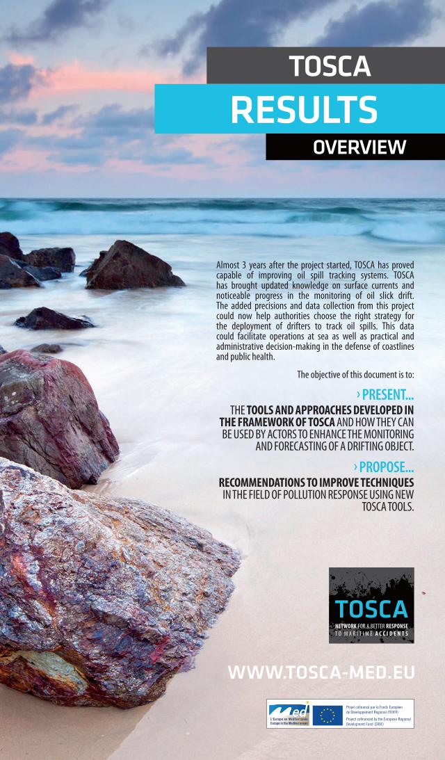
MONITORING OF AN OIL SPILLHF RADAR: A POWERFUL TOOL TO PROVIDE REAL-TIME VISIBILITY ON SURFACE CURRENTSThe TOSCA project observational network that was set up in five high-risk areas has showed that data from radars can provide real-time visibility of coastal surface currents. HF radars are the only way to obtain a relatively large coverage of surface currents (spatial and temporal resolution). The contribution of this data gives additional accuracy to the numerical forecasting models currently in use by improving the initial conditions. An important data set has been obtained during the in-situ campaigns, very diverse according to the configuration of the coast and the winds and currents of the area. This data set is accessible through the geographical Information system developed by the project: “TOSCA GIS”.
DRIFTERS PUT THROUGH THEIR PACESDuring the experiments, TOSCA partners attested that drifters could supply crucial data on currents and on the transport of oil-spills. The evaluation of different designs of drifters has emphasized the most suitable type to be used according to the operation (oil-spill or S&R). Moreover, an optimal deployment of groups of several floating buoys provides direct information on dispersion and how long it takes for a slick to double in size. In that sense, drifters could enable authorities to focus search or cleanup operations within a more clearly defined area in the case of a maritime accident.
Tracking the slick, day and night
While very common in the United States, the use of radars for observing surface currents is still quite new in Europe. A better knowledge of surface currents does significantly improve capacities for tracking drift pathways. Moreover, HF radars observations can improve the model initial conditions, can complement the daytime satellite and aerial monitoring, and can be used as ground truth for backtracking calculations.
Drifters, a convenient and inexpensive mean
of action
The drifters are a convenient and inexpensive mean of
action, complementary to radar. Drifters can be released
easily in the water, both by ship and by aircraft. Drifters provide information on the
current and direct information on transport and the relative
dispersion of an oil spill.
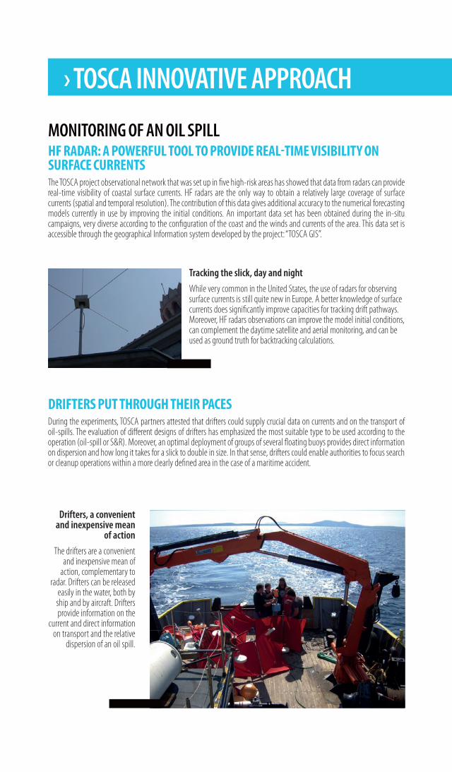
STRATEGIES TO IMPROVE EXISTING FORECASTING SYSTEMSDuring TOSCA, techniques aiming at improving existing forecasting systems through radars and drifters observations have been developed. One of the main results of this strategy is the LAVA software, described in the TOSCA tools section.
FORECASTING AN OIL SPILL TRAJECTORYIMPROVING OIL SPILL/TRAJECTORY FORECAST IN CASE OF A MARITIME ACCIDENTMonitoring and forecasting material transport in areas of high pollution risk is of major importance for controlling and mitigating damages caused by a maritime accident. Modeling systems (using atmospheric and oceanic predictions to provide the background for pollutants dispersion forecasts) are becoming a powerful tool in the hands of local authorities and public administrations involved in environmental and maritime safety issues.
Five such systems have been implemented and validated in 5 test sites around the Mediterranean Sea (Balearic Islands, Northwestern Mediterranean, Gulf of Napoli, Gulf of Trieste and North Aegean). At each test site, forecasting simulations have been performed, at the same time when HF radar and drifter track observations were available, to test the accuracy of the models and identify the source and type of errors.
CONSTRUCTION OF AN OBSERVATIONAL NETWORK BASED ON STATE OF THE ART TECHNOLOGYThrough the construction of an observational network, based on state of the art technology (HF radars and drifters), the project has provided, during the experimentation periods, real-time observations and forecasts of the marine environmental conditions in the Western and Eastern part of the Mediterranean Sea. If the use of radars and drifters were to be extended, the observational network could deliver real-time information to the relevant authorities.
› TOSCA TOOLS
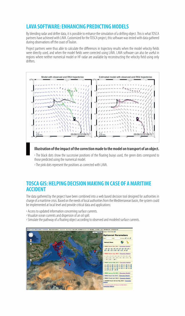
Example of a «Spill Track» drifter
Specially adapted for TOSCA, “Spill Track” is designed to monitor oil
spill position in the sea using fins made from lipophilic material. These
drifters are designed to better stick to the oil spill.
OPTIMIZATION OF DRIFTERS ACCORDING TO THE TYPE OF OPERATION (OIL-SPILL TRACKING OR SAR OPERATIONS) During the TOSCA experiments, different designs of drifters were made available by partners in view of assessing their water or oil-following capabilities and define the most suitable type to be used according to the operation (oil-spill or S&R). All drifters have been optimized with state-of-the-art communication technologies, allowing an easy set-up and regular communication on their successive positions.
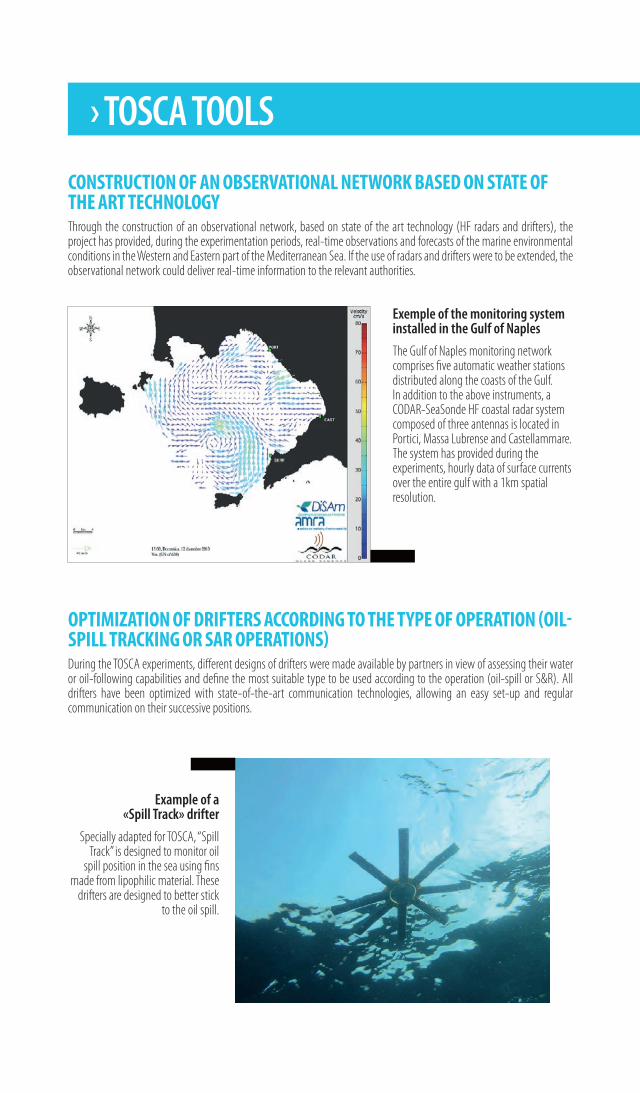
Exemple of the monitoring system installed in the Gulf of Naples
The Gulf of Naples monitoring network comprises five automatic weather stations distributed along the coasts of the Gulf. In addition to the above instruments, a CODAR-SeaSonde HF coastal radar system composed of three antennas is located in Portici, Massa Lubrense and Castellammare. The system has provided during the experiments, hourly data of surface currents over the entire gulf with a 1km spatial resolution.
TOSCA GIS: HELPING DECISION MAKING IN CASE OF A MARITIME ACCIDENT The data gathered by the project have been combined into a web based decision tool designed for authorities in charge of a maritime crisis. Based on the needs of local authorities from the Mediterranean basin, the system could be implemented at local level and provide critical data and applications:
› Access to updated information concerning surface currents.› Visualize ocean currents and dispersion of an oil spill.› Simulate the pathway of a floating object according to observed and modeled surface currents.
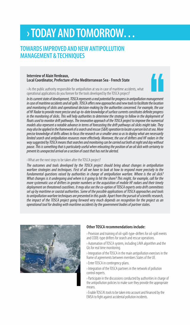
Illustration of the impact of the correction made to the model on transport of an object.
› The black dots show the successive positions of the floating buoys used, the green dots correspond to those predicted using the numerical model.› The pink dots represent the positions as corrected with LAVA.
LAVA SOFTWARE: ENHANCING PREDICTING MODELSBy blending radar and drifter data, it is possible to enhance the simulation of a drifting object. This is what TOSCA partners have achieved with LAVA. Customized for the TOSCA project, this software was tested with data gathered during observations off the coast of Toulon.
Project partners were thus able to calculate the differences in trajectory results when the model velocity fields were directly used, and when the model fields were corrected using LAVA. LAVA software can also be useful in regions where neither numerical model or HF radar are available by reconstructing the velocity field using only drifters.
Interview of Alain Verdeaux,Local Coordinator, Prefecture of the Mediterranean Sea - French State
› As the public authority responsible for antipollution at sea in case of maritime accidents, what operational applications do you foresee for the tools developed by the TOSCA project?In its current state of development, TOSCA represents a real potential for progress in antipollution management in case of maritime accidents and oil spills. TOSCA offers new approaches and new tools to facilitate the location and monitoring of slicks and operational decision-making by the authorities concerned. For example, the use of HF Radar to provide more precise and up-to-date knowledge of surface currents constitutes definite progress in the monitoring of slicks. This will help authorities to determine the strategy to follow in the deployment of floats used to monitor drift pathways. The innovative approach of the TOSCA project to improve the numerical models also represent a notable advance in terms of forecasting the drift pathways oil slicks might take. They may also be applied in the framework of a search and rescue (S&R) operation to locate a person lost at sea. More precise knowledge of drifts allows to focus the research on a smaller area so as to deploy what are necessarily limited search and antipollution resources more effectively. Moreover, the use of drifters and HF radars in the way suggested by TOSCA means that searches and monitoring can be carried out both at night and day without pause. This is something that is particularly useful when relocating the position of an oil slick with certainty to prevent its unexpected arrival on a section of coast that has not be alerted.
› What are the next steps to be taken after the TOSCA project?The outcomes and tools developed by the TOSCA project should bring about changes in antipollution warfare strategies and techniques. First of all we have to look at how to respond more precisely to the fundamental questions raised by authorities in charge of antipollution warfare. Where is the oil slick? What changes is it undergoing and where is it going to hit the shore? This might, for example, call for the more systematic use of drifters in greater numbers or the acquisition of mobile HF radars and their timely deployment on threatened coastlines. It may also see the co-option of TOSCA experts onto drift committees set up by maritime or coastal authorities. Some of the possible applications of TOSCA approaches and tools to antipollution warfare techniques are presented in this guide. Apart from the pursuit of scientific research, the impact of the TOSCA project going forward very much depends on recognition for the project as an operational tool for dealing with maritime accidents by the government bodies of partner states.
Other TOSCA recommendations include:
› Provision and training of oil-spill-type-drifters for oil-spill events and CODE-type drifters for search and rescue operations. › Automation of TOSCA system, including LAVA algorithm and the GIs for real time monitoring.› Integration of the TOSCA in the main antipollution exercises in the frame of agreements between members States of the UE.› Enter TOSCA in contingency plans.› Integration of the TOSCA partners in the network of pollution control experts.› Participate in the discussions conducted by authorities in charge of the antipollution policies to make sure they provide the appropriate means.› Enable TOSCA’s tools to be taken into account and financed by the EMSA to fight against accidental pollution incidents.
› TODAY AND TOMORROW…TOWARDS IMPROVED AND NEW ANTIPOLLUTION MANAGEMENT & TECHNIQUES
PROMOTING TOSCAFROM AN EXPERIMENTAL TO AN OPERATIONAL TOOLInterview of Anne Molcard, Scientific Coordinator, Mediterranean Institute of Oceanology (MIO) of the University of Sud Toulon-Var
› TOSCA is now in its 3rd & last year, what are the main conclusions concerning the projects outputs?We have shown that actual methods, based primarily on numerical models, have major limitations. This is particularly due to a lack of observational data. The use of HF radars can provide real-time mapping of surface currents, day and night and supplement current observational methods (aircraft or satellite observation). We have also shown that the use of specifically designed drifters (oil-spill or S&R) can provide low-cost and immediate information on surface currents and dispersal. The observations obtained using radars or drifters can also be used to provide data for numerical models to improve forecasting.
› What are the main perspectives?The TOSCA project has allowed to implement a prototype that could become operational and be integrated into existing crisis management systems. For this to happen, a Mediterranean network of radars needs to be created, with a particular focus on critical coastal areas (high risk regions: large harbours, oil-refineries, areas of marine traffic convergence, oil-pipeline end-points and environmentally sensitive areas). This network would then have to be constantly maintained and monitored. The methodologies implemented by TOSCA (data numerical models, LAVA) need to be automated and integrated into existing operational systems throughout the Mediterranean, in collaboration with projects such as MEDESS-4MS. We can also look to the industrial development, at a European level, of different types of drifters, designed for crisis situations and which could allow us to supply container ships, liners, oil platforms with a significant number of drifters to be used in case of a maritime accident.