Embed Size (px)
Citation preview
1 Jacksons Road & 634 Wellington Road, Mulgrave Economic report for rezoning from Commercial 2 Zone to Mixed Use Zone
Frondell Properties Pty Ltd 3 December 2018

Deep End Services Deep End Services is an economic research and property consulting firm based in Melbourne. It provides a range of services to local and international retailers, property owners and developers including due diligence and market scoping studies, store benchmarking and network planning, site analysis and sales forecasting, market assessments for a variety of land uses, and highest and best use studies.
Contact Deep End Services Pty Ltd Suite 304 9-11 Claremont Street South Yarra VIC 3141
T +61 3 8825 5888 F +61 3 9826 5331 deependservices.com.au
Enquiries about this report should be directed to:
Name Chris Abery [email protected]
Document Name Economic report Jacksons Rd & Wellington Rd sites Mulgrave - 3 Dec 2018 03.12.18
Disclaimer This report has been prepared by Deep End Services Pty Ltd solely for use by the party to whom it is addressed. Accordingly, any changes to this report will only be notified to that party. Deep End Services Pty Ltd, its employees and agents accept no responsibility or liability for any loss or damage which may arise from the use or reliance on this report or any information contained therein by any other party and gives no guarantees or warranties as to the accuracy or completeness of the information contained in this report.
This report contains forecasts of future events that are based on numerous sources of information as referenced in the text and supporting material. It is not always possible to verify that this information is accurate or complete. It should be noted that information inputs and the factors influencing the findings in this report may change hence Deep End Services Pty Ltd cannot accept responsibility for reliance upon such findings beyond six months from the date of this report. Beyond that date, a review of the findings contained in this report may be necessary.
This report should be read in its entirety, as reference to part only may be misleading.

1 Jacksons Road & 634 Wellington Road, Mulgrave
Deep End Services
1 Introduction 1 2 Location and planning context 3 2.1 Site description 3
Location 3 2.2 Existing buildings & uses 7
1 Jacksons Road 7 634 Wellington Road 8
2.3 Zoning 9 2.4 Local planning policy 10
Cl 21.04 Residential Development 12 Cl 21.05 Economic Development 13 Cl 21.07 Business Parks and Industry 13
2.5 Monash Industrial Land Use Strategy 14 2.6 Policy implications for the subject sites 15 3 Proposed rezoning & Design Development Overlay 16 4 Commercial and Industrial Land Supply 18 4.1 Regional supply & vacancy 18 4.2 Properties for lease 21 4.3 Conclusions 23 5 Economic benefits 24 5.1 Demographic shifts 24 5.2 Medical centre 27 5.3 Child care centre 27 5.4 Housing mix and affordability 28 5.5 Commercial accommodation 30 5.6 Other uses 31 5.7 Employment benefits 31 6 Conclusions 33
Contents
1 Jacksons Road & 634 Wellington Road, Mulgrave
Deep End Services
Table 1—Industrial land supply and occupancy 2006-2017 (ha) 19 Table 2—Industrial & office properties listed for lease by suburb 22 Table 3—Mulgrave – Wheelers Hill demographics (2016) 25 Figure 1—Regional location 2 Figure 2—Locality 4 Figure 3—Aerial image - 7 October 2018 5 Figure 4—Historic images of Mulgrave & Waverley Park 6 Figure 5—Site photos 8 Figure 6—Site photos 9 Figure 7—Zoning 10 Figure 8—City of Monash Strategic Framework Plan 12 Figure 9—Monash Industrial Land Use Strategy recommendation 14 Figure 10—Outer East Industrial-type zones 20 Figure 11—Office-warehouses for lease (>3,000 sqm) 22 Figure 12—Change in household structure 2016-2036 26 Figure 13—Medical Centres 27 Figure 14—Child care centres 28 Figure 15—Median house & unit prices 29 Figure 16—Retirement Villages & Aged Care 30 Figure 17—Commercial accommodation 31
Tables + Figures
1
1 Jacksons Road & 634 Wellington Road, Mulgrave
Deep End Services
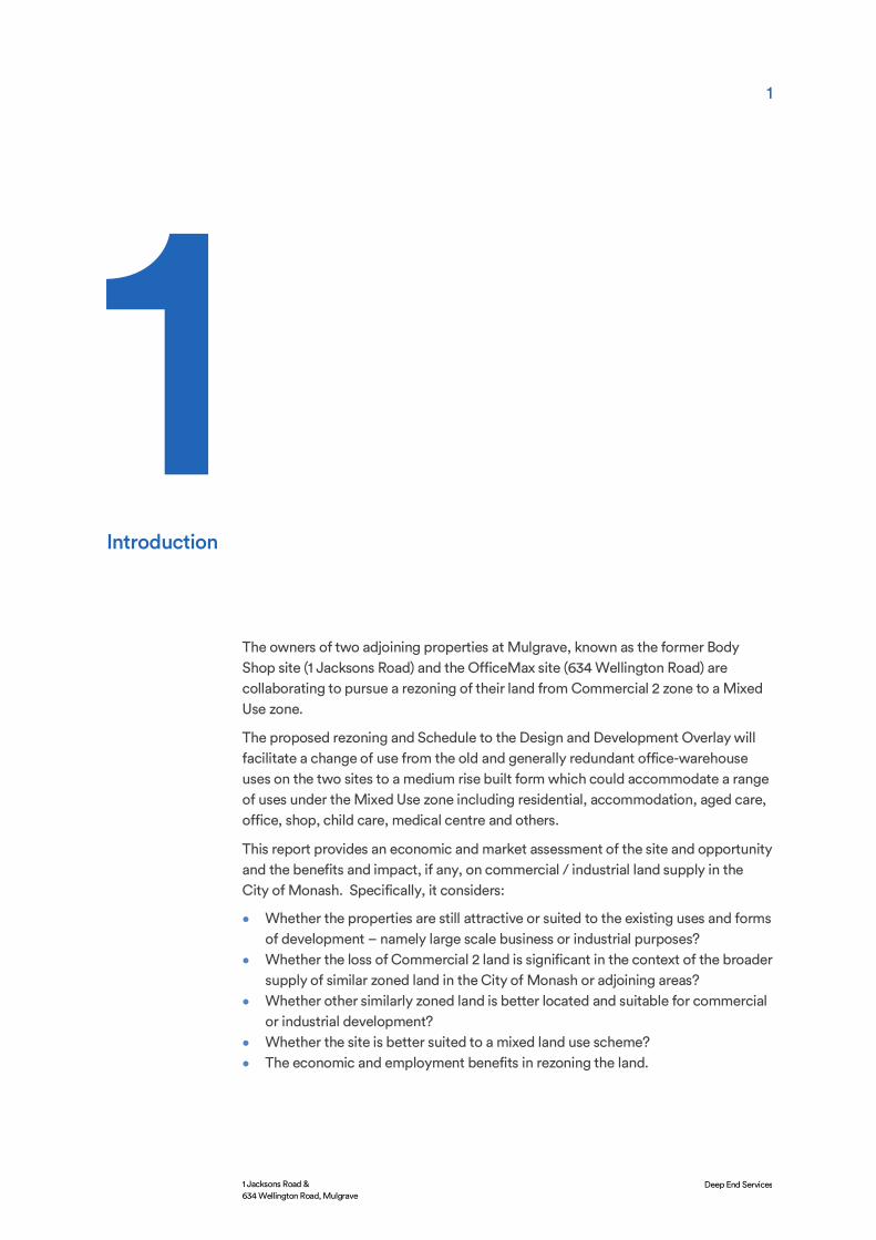
The owners of two adjoining properties at Mulgrave, known as the former Body Shop site (1 Jacksons Road) and the OfficeMax site (634 Wellington Road) are collaborating to pursue a rezoning of their land from Commercial 2 zone to a Mixed Use zone.
The proposed rezoning and Schedule to the Design and Development Overlay will facilitate a change of use from the old and generally redundant office-warehouse uses on the two sites to a medium rise built form which could accommodate a range of uses under the Mixed Use zone including residential, accommodation, aged care, office, shop, child care, medical centre and others.
This report provides an economic and market assessment of the site and opportunity and the benefits and impact, if any, on commercial / industrial land supply in the City of Monash. Specifically, it considers:
• Whether the properties are still attractive or suited to the existing uses and forms of development – namely large scale business or industrial purposes?
• Whether the loss of Commercial 2 land is significant in the context of the broader supply of similar zoned land in the City of Monash or adjoining areas?
• Whether other similarly zoned land is better located and suitable for commercial or industrial development?
• Whether the site is better suited to a mixed land use scheme? • The economic and employment benefits in rezoning the land.
Introduction

2
1 Jacksons Road & 634 Wellington Road, Mulgrave
Deep End Services
Figure 1—Regional location
Source: Ausway. Mapinfo,

3
1 Jacksons Road & 634 Wellington Road, Mulgrave
Deep End Services
Location
The subject sites (1 Jacksons Road and 634 Wellington Road) are located on the south-west corner of Jacksons Road and Wellington Road in the City of Monash (refer Figure 2).
The separate but adjoining properties have a combined site area of approximately 5.3 hectares and long-established office-warehouse uses. The land falls sharply from its west boundary to Jacksons Road with both sites cut into the natural levels. The existing uses are anomalous with the surrounding area which is characterised by established housing estates, a large retirement village and new housing on Mirvac’s Waverley Park site.
Wellington Road is a 6-lane divided arterial which crosses the metropolitan area between Brighton (North Road) and Lysterfield in the Dandenong Ranges. Where it passes the two sites it carries about 40,000 vehicles per day1. The Mulgrave section of Wellington Road is an important link between the Monash Freeway (1.4 km west of the site) and Eastlink (1.4 km east).
Jacksons Road extends south from Wellington Road as an important north-south link, passing under the Monash Freeway at Waverley Gardens Shopping Centre to the Princes Highway at Noble Park. At this point, it becomes Chandler Road and continues for another 4.3 km to Cheltenham Road and the Dandenong Bypass.
Wellington Road is the physical boundary between the suburbs of Wheelers Hill to the north and Mulgrave to the south. Wheelers Hill has had a stable population of over the last 10 years edging up from 20,600 in 2006 to almost 21,00 in 2016. Mulgrave to the south has grown by about 20% in the same period to almost 20,500
1 Source: Vic Roads Traffic Volume Data – February 2016.
Location and planning context
2.1 Site description

4
1 Jacksons Road & 634 Wellington Road, Mulgrave
Deep End Services
people – mainly through the redevelopment of the former Waverley Park football ground.
The area surrounding the site is characterised by:
• Established housing estates in Wheelers Hill and Mulgrave developed from the late 1960’s through to the late 1980’s.
• The 250-unit Cumberland Village Retirement Village and Aged Care facility on the north side of Wellington Road, opposite the site.
• New housing through the Waverley Park estate. Mirvac acquired the 86 hectares of land which housed the former Waverley Park football ground and its car parking areas in 2001. The land has been progressively developed with townhouses and two-storey homes with the last stage off Jacksons Road now selling. At full development, the area is expected to have 1,400 dwellings or over 3,000 people. The oval and former members stand has been retained and redeveloped as a training venue and administration facility for the Hawthorn Football Club and small community hub with a neighbourhood café, fish & chip shop, convenience store, Goodlife Health Club, dentist and physiotherapist.
• An industrial area of 31 hectares west of Waverley Park bounded by Wellington Road and the Monash Freeway. About two-thirds of this area is Woolworths’ Victorian distribution centre and state offices. The balance of the industrial land is occupied by Ensign Laboratories and Renold manufacturing.
Figure 2—Locality

5
1 Jacksons Road & 634 Wellington Road, Mulgrave
Deep End Services
Figure 3—Aerial image - 7 October 2018
Source: Nearmap, Deep End Services

6
1 Jacksons Road & 634 Wellington Road, Mulgrave
Deep End Services
The significant land use changes which have occurred from the early development of 1 Jacksons Road in 1972 can be seen in the following images.
In 1970 – two years before the office-warehouse at 1 Jacksons Road was built by Motorola – the Waverley Park football ground was completed and the Mulgrave Freeway (Monash Freeway) between Warrigal Road Chadstone and the Princes Highway at Eumemmering was under construction – later opened in 1972. The image shows rural land beyond Waverley Park and the first estates at Wheelers Hill (then known as Mulgrave) north of Wellington Road.
The second image from 1975 shows the extent of the football ground and parking up to the site (where the Motorola complex was complete) and the first stages of residential subdivision in Mulgrave, east of Jacksons Road.
Figure 3 shows the site today is effectively a small but isolated pocket of industrial land surrounded by residential uses.
Figure 4—Historic images of Mulgrave & Waverley Park

7
1 Jacksons Road & 634 Wellington Road, Mulgrave
Deep End Services
1 Jacksons Road
The 3.6 hectare site is developed with a 45-year old office-warehouse that predates most of the housing and other uses along Wellington Road. Existing improvements are:
• A 2-level office building of 2,500 sqm (including common areas). Approximately 500 sqm of the building is currently used by Link Health and Community for administration purposes. About 35 office staff are employed on site.
• A child care centre occupying approximately 650 sqm plus outdoor areas. It employs approximately 35 staff.
• A 4,000 sqm warehouse of which only 100 sqm is used employing three staff.
The site has large under-utilised parking areas terraced across the falling levels and extensive landscaping to Wellington Road and Jacksons Road. The landscaping, extensive set-backs and elevated position of the office building above Jacksons Road affords limited exposure and sight lines to the current uses.
The site has an all-movement exit and entry point on Jacksons Road and an exit only to Wellington Road for small vehicles.
The previous long-term tenant (The Body Shop) at 1 Jacksons Road vacated the building after the business was sold and the new owners (L’Oreal) relocated staff to offices at Chadstone. The warehouse function moved to an external third-party-logistics supplier with better warehouse capabilities. Staff of the former owners of the Body Shop (Adidem) moved to new premises in South Melbourne, more suited to the new organisational size and structure.
The weekly Mulgrave Farmers Market has operated from the site under the management of the Wise Foundation for many years. The popular local fixture operates every Sunday (8am – 1pm) with up to 70 primary producers, food and craft stalls. Funds raised from the market help fund charitable projects supported by the Wise Foundation.
The Jacksons Road site was developed when it sat on Melbourne’s outer eastern fringe. In the early 1970’s it would have presented as an attractive opportunity due to:
• Its corner location on two major roads. • The new Safeway (Woolworths) distribution centre on Wellington Road. • New housing subdivisions through Mulgrave and particularly high quality
housing to the north (Wheelers Hill). • Recent construction of VFL Park Waverley and either vacant land or uses of low
sensitivity on the property’s direct boundaries. • Mulgrave Freeway construction that would significantly reduce commuter travel
times to and from the outer east.
Forty five years on, the owners advise there are significant issues around re-letting the existing warehouse and office building including:
• Major repairs to the warehouse slab and loading docks due to the age of the building.
2.2 Existing buildings & uses
8
1 Jacksons Road & 634 Wellington Road, Mulgrave
Deep End Services
• The current racking system was designed specifically for The Body Shop and is unsuitable for many potential tenants.
• The racking and sprinkler systems need upgrading to comply with new safety regulations.
• The warehouse is not large enough for a modern third-party-logistics operation. • The Office - warehouse layout and staff amenities are inadequate for modern
standards and operations. • Site and operational costs of the warehouse are not competitive with other
nearby, larger warehouses. • Other new industrial estates with good connections to Eastlink have reduced the
competitive advantage of a warehouse location on Wellington Road.
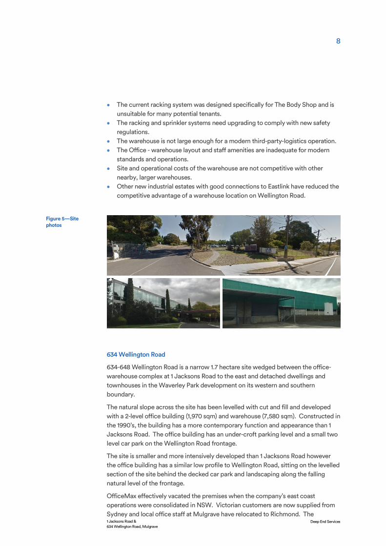
634 Wellington Road
634-648 Wellington Road is a narrow 1.7 hectare site wedged between the office-warehouse complex at 1 Jacksons Road to the east and detached dwellings and townhouses in the Waverley Park development on its western and southern boundary.
The natural slope across the site has been levelled with cut and fill and developed with a 2-level office building (1,970 sqm) and warehouse (7,580 sqm). Constructed in the 1990’s, the building has a more contemporary function and appearance than 1 Jacksons Road. The office building has an under-croft parking level and a small two level car park on the Wellington Road frontage.
The site is smaller and more intensively developed than 1 Jacksons Road however the office building has a similar low profile to Wellington Road, sitting on the levelled section of the site behind the decked car park and landscaping along the falling natural level of the frontage.
OfficeMax effectively vacated the premises when the company’s east coast operations were consolidated in NSW. Victorian customers are now supplied from Sydney and local office staff at Mulgrave have relocated to Richmond. The
Figure 5—Site photos

9
1 Jacksons Road & 634 Wellington Road, Mulgrave
Deep End Services
Wellington Road office is vacant and the warehouse only used on an occasional and temporary basis.
The land and buildings offer better re-letting prospects than 1 Jacksons Road however the site has its limitations in respect to:
• The relatively poor exposure and visibility to Wellington Road. • Left in and out vehicle movement to Wellington Road only. • 20 residential properties directly abutting or overlooking the site. • For a warehouse of this size, limited outdoor and hardstand areas for circulation
or external materials storage and vehicle parking.
Both sites now face site-specific limitations in terms of their re-letting potential, some of which have been listed. The broader issues for the two isolated industrial buildings are:
• The perceived advantages of these sites in the 1970’s (or even 1990’s) are not evident today as the residential interface has closed in, the industrial market has shifted and consolidated and new infrastructure has created more attractive locations.
• Competition from new or better located industrial estates and business parks in Monash or Knox with on-site amenities, better main road / freeway access, co-location benefits with other tenants and competitive rents.
• The steep natural fall across the site and 7 metre difference in building levels restricts any potential consolidation of the sites for uses other than residential.
Both sites are zoned Commercial 2 under the Monash Planning Scheme. Except for the two major roads, the combined sites form a small, isolated industrial node surrounded by the Neighbourhood Residential zone and General Residential zone on four sides.
In contrast, further west, the 30 hectares of Industrial 1 zone abutting Wellington Road and the Monash Freeway is a large and viable industrial precinct with larger
Figure 6—Site photos
2.3 Zoning
10
1 Jacksons Road & 634 Wellington Road, Mulgrave
Deep End Services
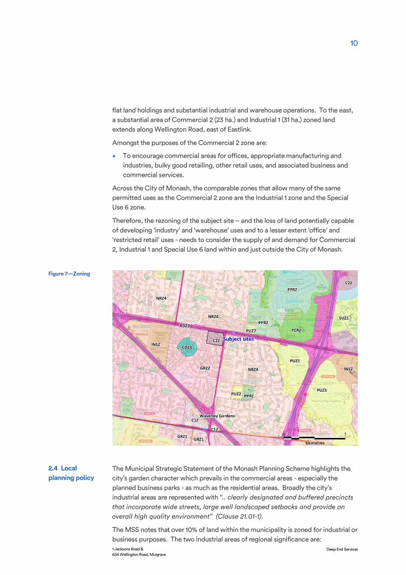
flat land holdings and substantial industrial and warehouse operations. To the east, a substantial area of Commercial 2 (23 ha.) and Industrial 1 (31 ha.) zoned land extends along Wellington Road, east of Eastlink.
Amongst the purposes of the Commercial 2 zone are:
• To encourage commercial areas for offices, appropriate manufacturing and industries, bulky good retailing, other retail uses, and associated business and commercial services.
Across the City of Monash, the comparable zones that allow many of the same permitted uses as the Commercial 2 zone are the Industrial 1 zone and the Special Use 6 zone.
Therefore, the rezoning of the subject site – and the loss of land potentially capable of developing ‘industry’ and ‘warehouse’ uses and to a lesser extent ‘office’ and ‘restricted retail’ uses - needs to consider the supply of and demand for Commercial 2, Industrial 1 and Special Use 6 land within and just outside the City of Monash.
The Municipal Strategic Statement of the Monash Planning Scheme highlights the city’s garden character which prevails in the commercial areas - especially the planned business parks - as much as the residential areas. Broadly the city’s industrial areas are represented with “.. clearly designated and buffered precincts that incorporate wide streets, large well landscaped setbacks and provide an overall high quality environment” (Clause 21.01-1).
The MSS notes that over 10% of land within the municipality is zoned for industrial or business purposes. The two industrial areas of regional significance are:
Figure 7—Zoning
2.4 Local planning policy

11
1 Jacksons Road & 634 Wellington Road, Mulgrave
Deep End Services
• The Monash Technology Precinct centred around Monash University which has become one of the most important precincts of its type in Australia. The locational advantages for industry are its central location, good access for its workforce and good access to the CBD. It has a strong educational base, existing physical infrastructure and available land and buildings within a landscaped environment.
• Larger areas of industrial land concentrated along the Oakleigh - Clayton rail corridor.
Outside these precincts, various small industrial areas are dispersed throughout the municipality.
The key influences which guide the City of Monash planning scheme and the critical land use issues that Council faces are detailed in Clause 21.01-2. These include:
• Moving towards sustainability where economic growth is achieved with social advancement and conservation of the natural environment, both resulting in a better quality of life.
• Maintaining Monash’s garden city character. • Changing lifestyle choices and demands of an aging population. The changing
age structure of Monash with declining household sizes and changes in household structures together with the desire for broader housing choice are regarded as key drivers of Monash’s future development. Council intends to ensure that construction of a diverse range of housing including aged accommodation is sufficient to cater for the desires of the population in the future.
• Activity and neighbourhood centre growth including directing more intensive, higher scale development to centres well serviced by public transport and commercial and community services.
• Growth in high technology and service industries employment with multiplier effects through the local economy. Manufacturing is also recognised as a key sector in the Monash economy.
• Neighbourhood character and heritage. Monash is essentially fully developed and is now experiencing a resurgence of housing development through dual occupancy and multi-unit developments. Redevelopment of Waverley Park, former school sites, other government land and poorly positioned industrial sites into other urban uses is occurring. The significant residential, commercial and industrial opportunities need to be facilitated while seeking to protect and enhance Monash’s physical, economic and social environments.
• Changing nature of industry and retail. The strong industrial base of Monash is gradually moving from blue collar to white collar industry, with a consequent change in the nature of industrial employment. Monash is facing the issue of balancing the needs of existing industry and the growth of demand for more office, warehouse and high technology uses in traditional industrial areas.
The strategic directions for future land use planning and development in the City of Monash are illustrated by the Strategic Framework Plan in Clause 21.01-3 (refer Figure 8).

12
1 Jacksons Road & 634 Wellington Road, Mulgrave
Deep End Services
The relevant strategic directions for business and industry and the potential redevelopment of the subject sites for mixed uses are:
• Identifying activity centres and promoting development and expansion of retail, entertainment, community and related facilities appropriate to the centre’s role.
• Directing residential growth to neighbourhood and activity centres, the Monash National Employment and Innovation Cluster and the Springvale Road and Princes Highway boulevards.
• Developing sustainable employment opportunities to maintain Monash as a predominant business location in Melbourne’s eastern region.
• Identifying the Monash Technology Precinct and promoting appropriate “high tech” development around Monash University and Monash Medical Centre.
• Identifying areas for revitalisation of older industrial premises.
The Planning Scheme outlines Key Strategic Statements for ten land use and development issues. The relevant land issues for the subject site are Residential development, Economic development and Business parks and industry.
Cl 21.04 Residential Development
Local policy recognises the ageing profile of the municipality which will have different housing and other needs to the existing population. Changes in lifestyle choices and family structures are also shifting preferences towards lower maintenance homes.
The objectives include providing housing for a diverse population that caters for different family and lifestyle preferences and a variety of residential environments
Figure 8—City of Monash Strategic Framework Plan
Source: Monash Planning Scheme Cl21.03-4
13
1 Jacksons Road & 634 Wellington Road, Mulgrave
Deep End Services
and urban experiences. The housing needs of an ageing population and students are specifically recognised.
The Strategies include maintaining a predominantly detached dwelling style in urban areas by promoting low rise development and directing high rise developments to the major centres of Glen Waverley and Oakleigh and medium rise developments to the Brandon Park, Clayton and Mount Waverley centres. The policy notes that, “The exceptions will be where there is an approved Structure Plan, or other planning mechanism in place or where individual circumstances support an alternative height”.
Cl 21.05 Economic Development
Monash is recognised as a major generator of jobs and wealth in Melbourne’s south east due to its natural location advantages and the presence of various education, health, research and business activities in the Monash Technology Precinct.
The policy notes investment in Monash continues to grow with further expansion of business parks and growth in its activity centres. Industry, business and activity centres need to continue to positively attract and retain local business to provide employment opportunities and investment.
Relevant issues under economic development which touch on the changes and transition of uses at the subject sites include:
• Rising energy prices, a desire for world’s best practice and more sustainable and efficient operations will impact economic development.
• A notable preference for clustering of businesses and industry in accessible and well-serviced locations.
• A notable loss of industrial premises in exchange for office-type or commercial industries.
The Objectives support business development and growth but also “… appropriate mixed use development while ensuring that the amenity of neighbourhoods is not affected”.
Cl 21.07 Business Parks and Industry
The policy states that Monash contains extensive land for traditional industry in Oakleigh, Huntingdale and Clayton and other smaller areas in Burwood, Mulgrave and Glen Waverley. It notes that clean industry with office-warehouse functions has experienced significant growth and is replacing the older industrial uses that have been in decline.
Council is concerned that further erosion of the traditional industrial base will diminish blue-collar employment opportunities with consequent socio-economic consequences and rising costs for existing businesses. It states that “Monash is committed to maintaining the amount of land set aside of industry, as these areas are proposed to retain their focus as areas that support large scale industrial activities”.
14
1 Jacksons Road & 634 Wellington Road, Mulgrave
Deep End Services
The Strategies include promoting the Monash Technology Precinct as Australia’s leading technology hub and encouraging redevelopment and revitalisation of older industrial areas.
The Monash Industrial Land Use Strategy (Draft) was prepared for the City of Monash in February 2014 by Charter Keck Kramer. It is not an incorporated or referenced document in the Municipal Strategic Statement or Local Planning Policies of the Monash Planning Scheme but has some weight as a planning document commissioned by Council.
Its stated purpose is to provide strategic direction to support the future planning and development of industrial land within the City of Monash including the rezoning of land for non-industrial purposes. It relates to (then) all Industrial 1 and Business 3 within the City of Monash excluding the Monash Technology Precinct.
The report details national and Melbourne-wide industry trends including the restructuring of old industries, increased specialisation, inner city demand and industrial construction activity and property market drivers.
The report evaluates 28 small and large industrial precincts in Monash and assesses their future potential on a range of criteria including demand levels generally in Monash, accessibility and infrastructure, redevelopment potential, alternative land uses, economic development, urban renewal and amenity impacts.
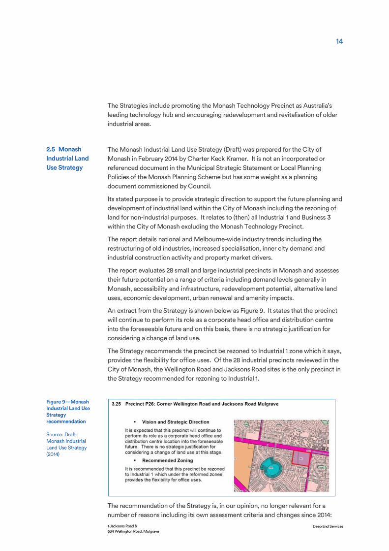
An extract from the Strategy is shown below as Figure 9. It states that the precinct will continue to perform its role as a corporate head office and distribution centre into the foreseeable future and on this basis, there is no strategic justification for considering a change of land use.
The Strategy recommends the precinct be rezoned to Industrial 1 zone which it says, provides the flexibility for office uses. Of the 28 industrial precincts reviewed in the City of Monash, the Wellington Road and Jacksons Road sites is the only precinct in the Strategy recommended for rezoning to Industrial 1.
The recommendation of the Strategy is, in our opinion, no longer relevant for a number of reasons including its own assessment criteria and changes since 2014:
2.5 Monash Industrial Land Use Strategy
Figure 9—Monash Industrial Land Use Strategy recommendation
Source: Draft Monash Industrial Land Use Strategy (2014)

15
1 Jacksons Road & 634 Wellington Road, Mulgrave
Deep End Services
• The buildings on both sites have been either vacant or underutilised for several years and on longer perform corporate head office and distribution centre functions.
• The buildings are dated and require significant capital to bring them to modern standards. These costs are prohibitive given the site constraints and low market interest in the location and superior office-warehouse buildings and amenities elsewhere.
• The Strategy has failed to give weight to the significant land use changes in the last 10years including the encroachment of residential uses from Waverley Park.
• It fails to consider the site’s redevelopment potential including its residential setting, elevated position and easterly outlook to the Dandenong Ranges.
• Rezoning of the land to Industrial 1 would only reinforce the isolated, anomalous land use with no connection to a broader and viable industrial area.
• The Jacksons Road and Wellington Road sites have similar or better attributes for rezoning to Mixed Use as five of the other precincts recommended for a Mixed Use zone under the Strategy.
Past and recent tenants at 1 Jacksons Road and 634 Wellington Road have not operated as traditional process-based industrial uses – activities that Council is concerned about losing. The buildings on the subject site have not displaced traditional industrial uses but were purpose-built for the warehousing and distribution of retail or consumer products with an associated regional or head office administration function.
These office-warehouse buildings and similar tenants are found extensively throughout the Industrial 1 and Special Use 6 zones of the City of Monash.
The subject sites are not identified as part of the two principal industrial – business precincts of the City of Monash. While the policy notes a smaller industrial area in Mulgrave, the reference more than likely refers to the 31 hectares of Industrial 1 zone abutting Wellington Road and the Monash Freeway.
The subject sites are a small, inconsequential part of the City’s industrial and business fabric. Council’s policy concerns about the loss of industrial land to other office-warehouse activities is not, in our view, relevant to the potential loss of two office-warehouse uses well outside the established industrial and business precincts.
From an employment perspective, a new mixed-use development will replace and indeed potentially increase the employment levels on site over the existing levels.
Other policy implications which are relevant to the proposed change of use are:
• The need for greater choice and diversity of housing to cater to changing lifestyles and preferences.
• The needs of the ageing population for health care and alternative forms of housing to the detached housing character of the outer suburbs.
• The needs of the growing population on the Waverley Park site which have limited on-site facilities.
2.6 Policy implications for the subject sites
16
1 Jacksons Road & 634 Wellington Road, Mulgrave
Deep End Services
The proposed amendments to the Monash Planning Scheme will rezone 1 Jacksons Road and 634 Wellington Road from Commercial 2 zone to Mixed Use zone with a new Design and Development Overlay (DDO) applying to the land which is referred to as an Urban Renewal Precinct.
The Mixed Use zone provides for a range of residential and commercial uses. It is an appropriate zone for the land given its two main road frontages, surrounding residential interface and elevated position with easterly views. The Mixed Use zone provides for housing at higher densities which would provide a natural transition from the master planned Waverley Park development.
The site’s high visibility and arterial road frontages with a signalised intersection provide opportunities for a range of commercial and other uses permitted under the zone including:
• Retail premises • Food & drink premises • Medical centre • Child care centre • Offices • Residential aged care facility • Commercial accommodation • Community uses
The DDO includes the following Design objectives:
• To support a staged transition from commercial / industrial to high quality mixed use development.
Proposed rezoning & Design Development Overlay
17
1 Jacksons Road & 634 Wellington Road, Mulgrave
Deep End Services
• To support the development of a medium rise built form character with appropriate transitions in building height from the precinct’s edges to its central areas having regard to the variable topography across the precinct.
• To ensure landscape design enhances the new character of the precinct and integrates the development with its context including the retention and ongoing health of the precinct’s high value trees.
• To ensure site planning, built form, scale and architectural qualities that deliver high quality interfaces with the private, communal and public realms and avoid unreasonable off site amenity impacts and reasonably protect views through the site.
• To ensure development provides a high standard of internal and external amenity for those living and working in, or visiting the precinct including the provision of adequate open space.
A staged site plan must be provided as part of any planning permit application for any residential development and must cover the entire lot. The site plan must show the stages of development, site layout, land use and yields and tree retention and open space provision.
The DDO divides the precinct into four sub-precincts each with specified development outcomes, building heights and setbacks to boundaries. Generally, buildings around the edge of the precinct can rise to 4 levels and in the central section up to 6 levels.
The Mixed Use zone and proposed DDO controls provide sufficient flexibility for a range of uses in a mid-rise development which can take advantage of the site’s location and natural advantages. A significant residential component would be expected in any future site plan.

18
1 Jacksons Road & 634 Wellington Road, Mulgrave
Deep End Services
The Jacksons Road and Wellington Road sites are developed with office and warehouse uses under the Commercial 2 zone. The most common land use categories permitted under the Commercial 2 zone that would be eventually replaced on the subject sites by rezoning the land to Mixed Use are industry, office, restricted retail premises and warehouse.
Any new Industry or Warehouse uses on either site would now require a permit under the Commercial 2 zone as both sites directly abut the residential zone which has encroached on the land with the development of Waverley Park. In other locations, where the Commercial 2 zone is more than 30 metres from a residential zone, most Industry and Warehouse uses do not require a permit.
The comparable zones where offices, warehouses, industry and restricted retail premises are Section 1 or Section 2 uses under the Monash Planning Scheme are the Industrial 1 zone and the Special Use 6 zone.
The developed and vacant land area under these zones is assessed across a study area which includes:
• The City of Monash. • Areas of Scoresby and Knoxfield in the City of Knox that fall within 6km of the
sites. • Areas of Springvale in the City of Greater Dandenong that fall within 6km of the
sites.
To address the questions of whether the rezoning of the subject land and the loss of the Commercial 2 zoning is significant in supply terms, the study area was interrogated using the State Government’s Urban Development Program (UDP) spatial data set.
Commercial and Industrial Land Supply
4.1 Regional supply & vacancy
19
1 Jacksons Road & 634 Wellington Road, Mulgrave
Deep End Services
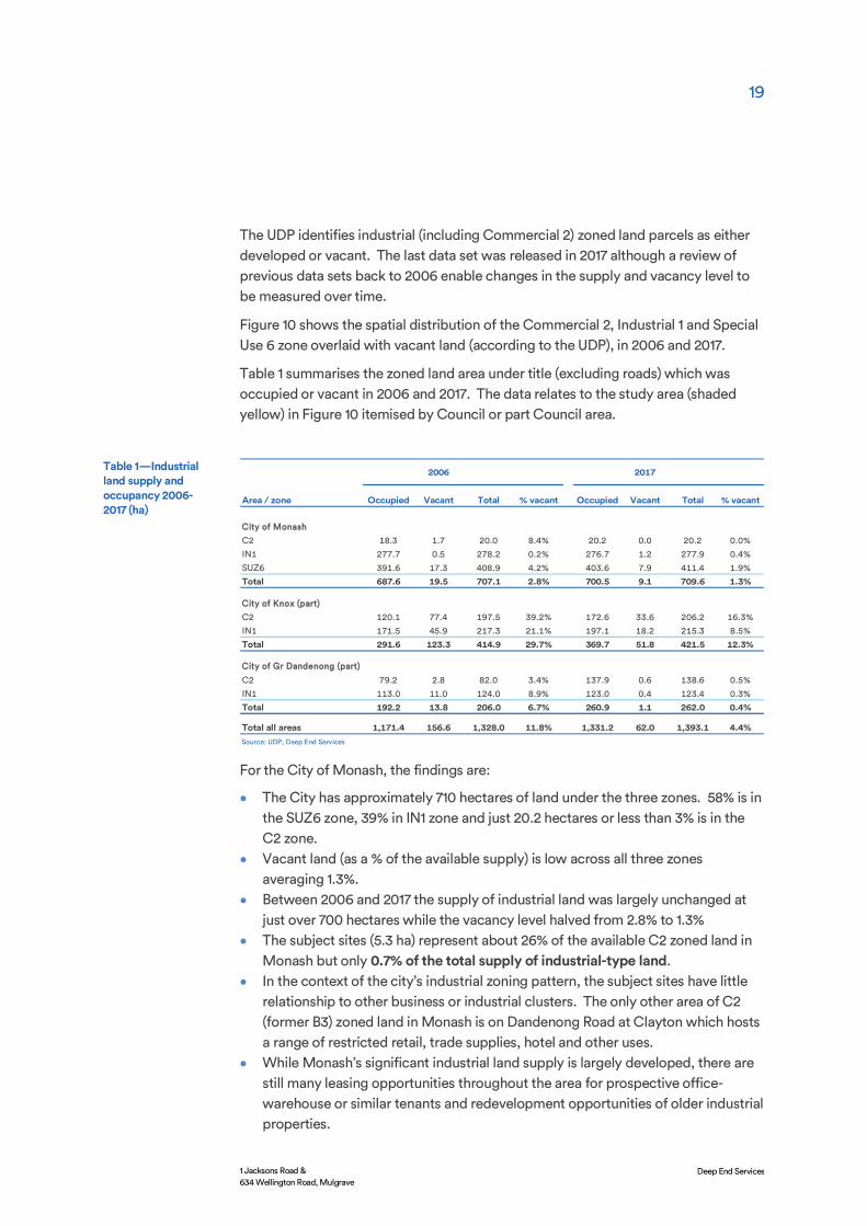
The UDP identifies industrial (including Commercial 2) zoned land parcels as either developed or vacant. The last data set was released in 2017 although a review of previous data sets back to 2006 enable changes in the supply and vacancy level to be measured over time.
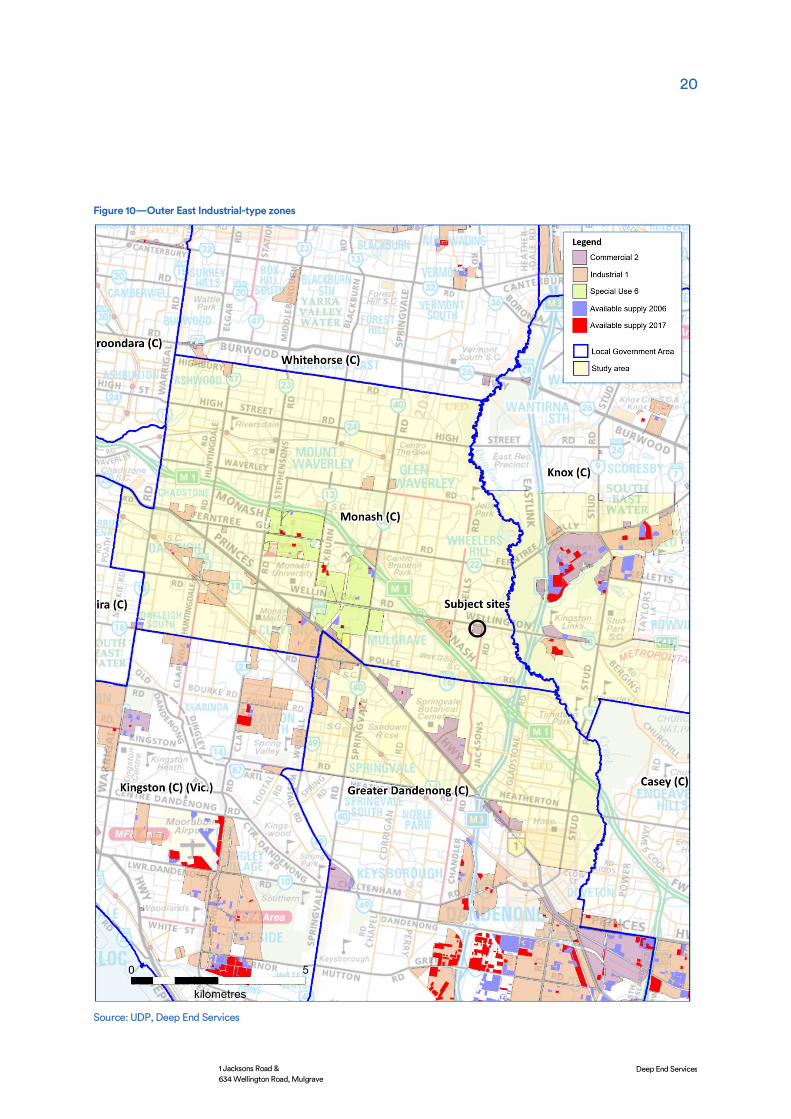
Figure 10 shows the spatial distribution of the Commercial 2, Industrial 1 and Special Use 6 zone overlaid with vacant land (according to the UDP), in 2006 and 2017.
Table 1 summarises the zoned land area under title (excluding roads) which was occupied or vacant in 2006 and 2017. The data relates to the study area (shaded yellow) in Figure 10 itemised by Council or part Council area.
For the City of Monash, the findings are:
• The City has approximately 710 hectares of land under the three zones. 58% is in the SUZ6 zone, 39% in IN1 zone and just 20.2 hectares or less than 3% is in the C2 zone.
• Vacant land (as a % of the available supply) is low across all three zones averaging 1.3%.
• Between 2006 and 2017 the supply of industrial land was largely unchanged at just over 700 hectares while the vacancy level halved from 2.8% to 1.3%
• The subject sites (5.3 ha) represent about 26% of the available C2 zoned land in Monash but only 0.7% of the total supply of industrial-type land.
• In the context of the city’s industrial zoning pattern, the subject sites have little relationship to other business or industrial clusters. The only other area of C2 (former B3) zoned land in Monash is on Dandenong Road at Clayton which hosts a range of restricted retail, trade supplies, hotel and other uses.
• While Monash’s significant industrial land supply is largely developed, there are still many leasing opportunities throughout the area for prospective office-warehouse or similar tenants and redevelopment opportunities of older industrial properties.
2006 2017
Area / zone Occupied Vacant Total % vacant Occupied Vacant Total % vacant
City of Monash
C2 18.3 1.7 20.0 8.4% 20.2 0.0 20.2 0.0%
IN1 277.7 0.5 278.2 0.2% 276.7 1.2 277.9 0.4%
SUZ6 391.6 17.3 408.9 4.2% 403.6 7.9 411.4 1.9%
Total 687.6 19.5 707.1 2.8% 700.5 9.1 709.6 1.3%
City of Knox (part)
C2 120.1 77.4 197.5 39.2% 172.6 33.6 206.2 16.3%
IN1 171.5 45.9 217.3 21.1% 197.1 18.2 215.3 8.5%
Total 291.6 123.3 414.9 29.7% 369.7 51.8 421.5 12.3%
City of Gr Dandenong (part)
C2 79.2 2.8 82.0 3.4% 137.9 0.6 138.6 0.5%
IN1 113.0 11.0 124.0 8.9% 123.0 0.4 123.4 0.3%
Total 192.2 13.8 206.0 6.7% 260.9 1.1 262.0 0.4%
Total all areas 1,171.4 156.6 1,328.0 11.8% 1,331.2 62.0 1,393.1 4.4%Source: UDP, Deep End Services
Table 1—Industrial land supply and occupancy 2006-2017 (ha)
20
1 Jacksons Road & 634 Wellington Road, Mulgrave
Deep End Services
Figure 10—Outer East Industrial-type zones
Source: UDP, Deep End Services

21
1 Jacksons Road & 634 Wellington Road, Mulgrave
Deep End Services
The City of Knox has a significant area of industrial land bordering Ferntree Gully Road and Eastlink only a short distance north-east of the subject sites. The area has 206 hectares of C2 zoned land and 215 ha of IN1 zone. The UDP indicates that 52 ha was still available for development in 2017, representing 16% of the C2 land and 9% of the IN1 land.
In the last 10 years, the market has developed about 65 hectares of industrial land with the proportion of vacant land falling from 30% to 12%. On current absorption rates the area has another 10-12 years of industrial land supply.
The Caribbean Business Park is a feature of the area with about 40 tenants occupying a range of high quality industrial / warehouse buildings. The master planned estate has wide roads, generous setbacks, attractive landscaping and the lakeside features of the Caribbean Market area. Four 6-level office buildings have been constructed since 2015 with another two now under construction. The southern section of the Business Park, where the new offices are located and other industrial buildings are planned, has direct south-bound access and egress lanes to Eastlink. Child care, outdoor leisure, restaurants and other amenities will be developed shortly.
Caribbean Business Park has a flexible Commercial 2 zoning and is the model for new industrial estates attracting office and industrial tenants from the inner and middle suburbs.
The northern areas of the City of Greater Dandenong – within 6km of the subject sites - also have extensive areas zoned IN1 (123 ha) and C2 (139 ha). The latter occurs in sections along Dandenong Road through Springvale down to Noble Park. These older established areas are fully developed with little or no vacant land. Like other areas of Monash however there are numerous redevelopment opportunities which can bring new supply to the market.
Overall, the outer south-east has a significant supply of industrial and related commercial-zoned land clustered in legible precincts. While the vacant land supply is low in established areas, land at Knox is attracting a steady rate of development.
The shortage of greenfield land for industrial development could, on one view, present an apparent shortage of leasing opportunities, however the existing supply of buildings throughout the region provides a wide choice of options at any given time for prospective companies looking to establish or move within the area.
Table 2 is a snap shot of the current industrial-warehouse properties over 3,000 sqm available for lease in the industrial areas of Monash and adjoining areas of Knox and Dandenong – sourced through the main on-line property websites. It shows the results of web site searches for the same areas in July 2017 and October 2018.
In the defined study area, there are 21 vacant properties which meet the minimum floorspace criteria. About half of these are in the City of Monash. The available premises was slightly less than the number recorded in 2017 (25). The spatial distribution of these properties is shown in Figure 11.
4.2 Properties for lease

22
1 Jacksons Road & 634 Wellington Road, Mulgrave
Deep End Services
The availability of properties – comparable to the office-warehouses on the subject sites – is generally strong throughout the region, noting availability is at the current time. Marketing information shows there is a range of new and high quality warehouses available now through Mulgrave, Clayton, Rowville and Scoresby.
Local Gov't Area / suburb
July 2017 October 2018
City of MonashClayton 4 5Oakleigh 4 3Mt Waverley 2 2Mulgrave 4 0Notting Hill - 1Huntingdale 1 1Oakleigh South 1 0Total Monash 16 12Knox (part)Scoresby 4 3Knoxfield 1 0Rowville 4 1Total Knox (part) 9 4Dandenong (part)Springvale - 1Noble Park North - 4Total Dandenong (part) - 5Total all areas 25 21Source: On-line commercial agency listings
Industrial -Warehouses for lease (>3,000 sqm)Table 2—Industrial & office properties listed for lease by suburb
Figure 11—Office-warehouses for lease (>3,000 sqm)
Commercial agency web sites
23
1 Jacksons Road & 634 Wellington Road, Mulgrave
Deep End Services
The two Commercial 2 zoned sites on Jacksons Road and Wellington Road have little or no strategic value to the supply of industrial land in the City of Monash or the wider region.
With the encroachment of the Waverley Park housing estate, the steep level changes across the sites and their isolated context, they would not be appropriate or viable as greenfield industrial sites today. 1 Jacksons Road has dated infrastructure and buildings and limited prospects of securing a long-term tenant when other modern properties on flat land and better access and road connections are available.
There is a significant supply and choice of office and industrial-warehouse properties across the City of Monash and the adjoining areas of Knox and Rowville. The proposed rezoning of the land and the loss of 5.3 hectares of Commercial 2 zoned land with two office-warehouses in this location is of no material significance to the economic base of the local area or the integrity of the city’s industrial land supply.
4.3 Conclusions

24
1 Jacksons Road & 634 Wellington Road, Mulgrave
Deep End Services
The population profile of the outer eastern suburbs of Monash has shifted significantly since the area was subdivided from the late 1960’s. These changes are driving a need for additional services and other forms of housing which directly relate to the proposed rezoning on the subject sites.
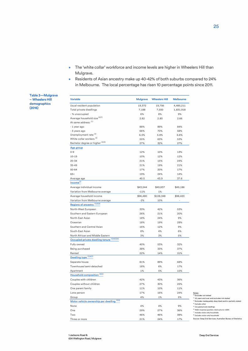
Table 3 presents 2016 Census data for the suburbs of Mulgrave and Wheelers Hill compared to the Melbourne average. The main characteristics are a family-based area of middle income levels which is ageing in detached dwellings and with a rising proportion of residents of Asian ancestry. The features are:
• Detached dwellings make up 93-94% of the dwelling stock in Mulgrave and Wheelers Hill compared to 72% across Melbourne. Apartments are just 1% and 5% of housing in Mulgrave and Wheelers Hill (Melbourne 15%).
• Housing stock heavily influences household characteristics. 42-43% of households are ‘couples with children’ and 27-30% ‘couples without children’ – both proportions are above Melbourne averages.
• The suburban character has families living in their homes for longer than average, many ageing in place since the suburbs were developed. This is reflected in the high proportion of families (53% in Wheelers Hill) that own their home. Home ownership is lower in Mulgrave (40%) but still higher than the Melbourne average (34%).
• In 2016, Wheelers Hill was an older area with 24% aged 50-64 years (Melb. 17%) and 24% aged 65+ (Melb. 14%). The elderly population reflects the presence of large retirement villages in the area however a significant population is, or has moved, into the older ‘retirement’ age groups since 2011. Mulgrave has a higher changeover of housing and new residents and its profile is younger and close to the Melbourne average.
Economic benefits
5.1 Demographic shifts
25
1 Jacksons Road & 634 Wellington Road, Mulgrave
Deep End Services
• The ‘white collar’ workforce and income levels are higher in Wheelers Hill than Mulgrave.
• Residents of Asian ancestry make up 40-42% of both suburbs compared to 24% in Melbourne. The local percentage has risen 10 percentage points since 2011.
Variable Mulgrave Wheelers Hill Melbourne
Usual resident population 19,372 19,756 4,485,211
Total private dwellings 7,188 7,500 1,831,918
- % unoccupied 6% 8% 9%
Average household size (5)(7) 2.82 2.80 2.66
At same address: (1)
- 1 year ago 88% 89% 84%
- 5 years ago 66% 70% 58%
Unemployment rate (2) 6.5% 5.8% 6.8%
White collar workers (2) 55% 63% 53%
Bachelor degree or higher (2)(3) 27% 32% 27%
Age group
0-9 12% 10% 13%
10-19 10% 12% 12%
20-34 21% 15% 24%
35-49 21% 19% 21%
50-64 17% 20% 17%
65+ 19% 24% 14%
Average age 40.0 43.9 37.6
Income(2)
Average individual income $43,544 $49,837 $49,186
Variation from Melbourne average -11% 1% -
Average household income $96,480 $108,348 $98,420
Variation from Melbourne average -2% 10% -
Regions of ancestry (1)(4)(8)
North-West European 33% 42% 53%
Southern and Eastern European 26% 21% 20%
North-East Asian 18% 24% 9%
Oceanian 18% 19% 28%
Southern and Central Asian 16% 12% 9%
South-East Asian 8% 4% 6%
North African and Middle Eastern 3% 3% 5%
Occupied private dwelling tenure (1)(4)(5)(6)
Fully owned 40% 53% 32%
Being purchased 38% 33% 37%
Rented 22% 14% 31%
Dwelling type (1)(4)(7)
Separate house 81% 89% 68%
Townhouse/semi-detached 18% 6% 17%
Apartment 1% 5% 15%
Household composition (4)(5)
Couples with children 42% 43% 36%
Couples without children 27% 30% 25%
One parent family 11% 10% 11%
Lone person 17% 16% 24%
Group 4% 1% 5%
Motor vehicle ownership per dwelling (1)(5)
None 4% 4% 9%
One 29% 27% 36%
Two 46% 46% 38%
Three or more 21% 24% 17%
Table 3—Mulgrave – Wheelers Hill demographics (2016)
Notes:(1) Excludes not stated(2) 15 years and over and excludes not stated(3) Excludes inadequately described and/or partially stated(4) Excludes other(5) Occupied private dwellings(6) Multi-response question; total sums to >100%(7) Includes visitor only households(8) Excludes visitor only households
Source: Deep End Services; Australian Bureau of Statistics

26
1 Jacksons Road & 634 Wellington Road, Mulgrave
Deep End Services
Population and household projections have been prepared by specialist demographers .id for the City of Monash. The results indicate:
• The population of Mulgrave will continue to grow slowly over the next 20 years – from 19,339 in 2016 to 20,569 in 2036.
• The population of Wheelers Hill will grow at a faster rate. Coming off a similar population base (to Mulgrave) of 20,989 people in 2016, it will add 2,643 people over the next 20 years to 23,632.
• Both areas will continue to age. While the population of both suburbs will increase by about 10% in the next 20 years, empty nesters (aged 60-69), seniors (70-84) and the elderly (85+ years) will all grow at faster rates.
• Household structures will also change. Figure 12 shows the projected growth or decline in household-types in Wheelers Hill and Mulgrave between 2016 and 2036. Traditional families will continue to grow throughout the area as older residents move from detached dwellings to other forms of housing. ‘Lone person households’ and ‘couples without dependents’ – reflecting the older age structure – will increase at a rapid rate, particularly in Wheelers Hill.
Source: .id
The implications of the demographic forecasts are:
• Traditional family structures will continue to dominate the outer areas as the underlying housing stock of single detached dwellings is only suited to larger families. The increase in families will bring demands for retail, medical and child care facilities close to where they live.
• The growing older population is increasingly unsuited to their long-held family homes and will be seeking aged living and ultimately aged-care options. Many of these residents will prefer to live in their local areas although relocating to other areas may be inevitable if appropriate housing is not available.
• The older age cohorts will have much higher demands on health services. • The large and growing population of Asian ethnicity will be strongly inclined to
apartment living in young and older age groups, if supply is available.
-50 0 50 100 150 200 250 300 350 400 450
Couple families with dependents
Couples without dependents
Group households
Lone person households
One parent family
Other families
Change in households 2016-2036Wheelers Hill Mulgrave
Figure 12—Change in household structure 2016-2036

27
1 Jacksons Road & 634 Wellington Road, Mulgrave
Deep End Services
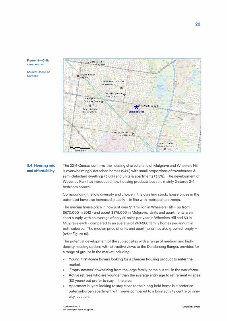
A potential medical (wellness) centre at 1 Jacksons Road with a full range of allied health services would respond well to the increasing and ageing population in the area. Figure 13 shows the distribution of medical centres through Wheelers Hill and Mulgrave.
The pattern reveals a cluster of clinics at Brandon Park and along Ferntree Gully Road in the northern part of Wheelers Hill and two clinics adjoining the Wheelers Hill Shopping Centre on Jells Road. The latter are well-placed in the community hub and are close to the large Weary Dunlop retirement village.
Further south, there is a second grouping along Police Road and near the Waverley Gardens Shopping Centre.
There are no medical centres along Wellington Road or near the subject sites. There is an apparent opportunity here to service the large retirement village opposite the sites, established areas through Wheelers Hill and Mulgrave and new residents in the Waverley Park development. A Wellness Centre would also operate from a potentially broader catchment where the site has a high profile and is accessible via the two major roads.
A new and larger child care centre, replacing the existing facility at 1 Jacksons Road, would serve a growing need in the area, mostly from the growing number of young families in the Waverley Park area.
Age-specific population projections by .id show the number of pre-school children in Mulgrave and Wheelers Hill will remain at stable levels for the next 20 years – fluctuating around 2,100 children aged 0-4 years. This underpins the existing distribution of child care centres.
5.2 Medical centre
Figure 13—Medical Centres
Source: Deep End Services
5.3 Child care centre
28
1 Jacksons Road & 634 Wellington Road, Mulgrave
Deep End Services
The 2016 Census confirms the housing characteristic of Mulgrave and Wheelers Hill is overwhelmingly detached homes (94%) with small proportions of townhouses & semi-detached dwellings (3.0%) and units & apartments (3.5%). The development of Waverley Park has introduced new housing products but still, mainly 2-storey 3-4 bedroom homes.
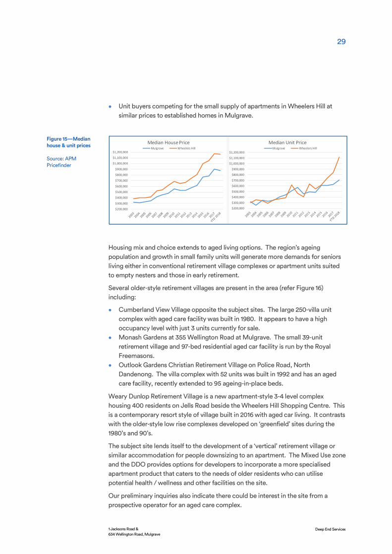
Compounding the low diversity and choice in the dwelling stock, house prices in the outer east have also increased steadily – in line with metropolitan trends.
The median house price in now just over $1.1 million in Wheelers Hill – up from $670,000 in 2012 - and about $875,000 in Mulgrave. Units and apartments are in short supply with an average of only 20 sales per year in Wheelers Hill and 50 in Mulgrave each - compared to an average of 240-260 family homes per annum in both suburbs. The median price of units and apartments has also grown strongly – (refer Figure 15).
The potential development of the subject sites with a range of medium and high-density housing options with attractive views to the Dandenong Ranges provides for a range of groups in the market including:
• Young, first-home buyers looking for a cheaper housing product to enter the market.
• ‘Empty nesters’ downsizing from the large family home but still in the workforce. • Active retirees who are younger than the average entry age to retirement villages
(80 years) but prefer to stay in the area. • Apartment buyers looking to stay close to their long-held home but prefer an
outer suburban apartment with views compared to a busy activity centre or inner city location.
Figure 14—Child care centres
Source: Deep End Services
5.4 Housing mix and affordability
29
1 Jacksons Road & 634 Wellington Road, Mulgrave
Deep End Services
• Unit buyers competing for the small supply of apartments in Wheelers Hill at similar prices to established homes in Mulgrave.
Housing mix and choice extends to aged living options. The region’s ageing population and growth in small family units will generate more demands for seniors living either in conventional retirement village complexes or apartment units suited to empty nesters and those in early retirement.
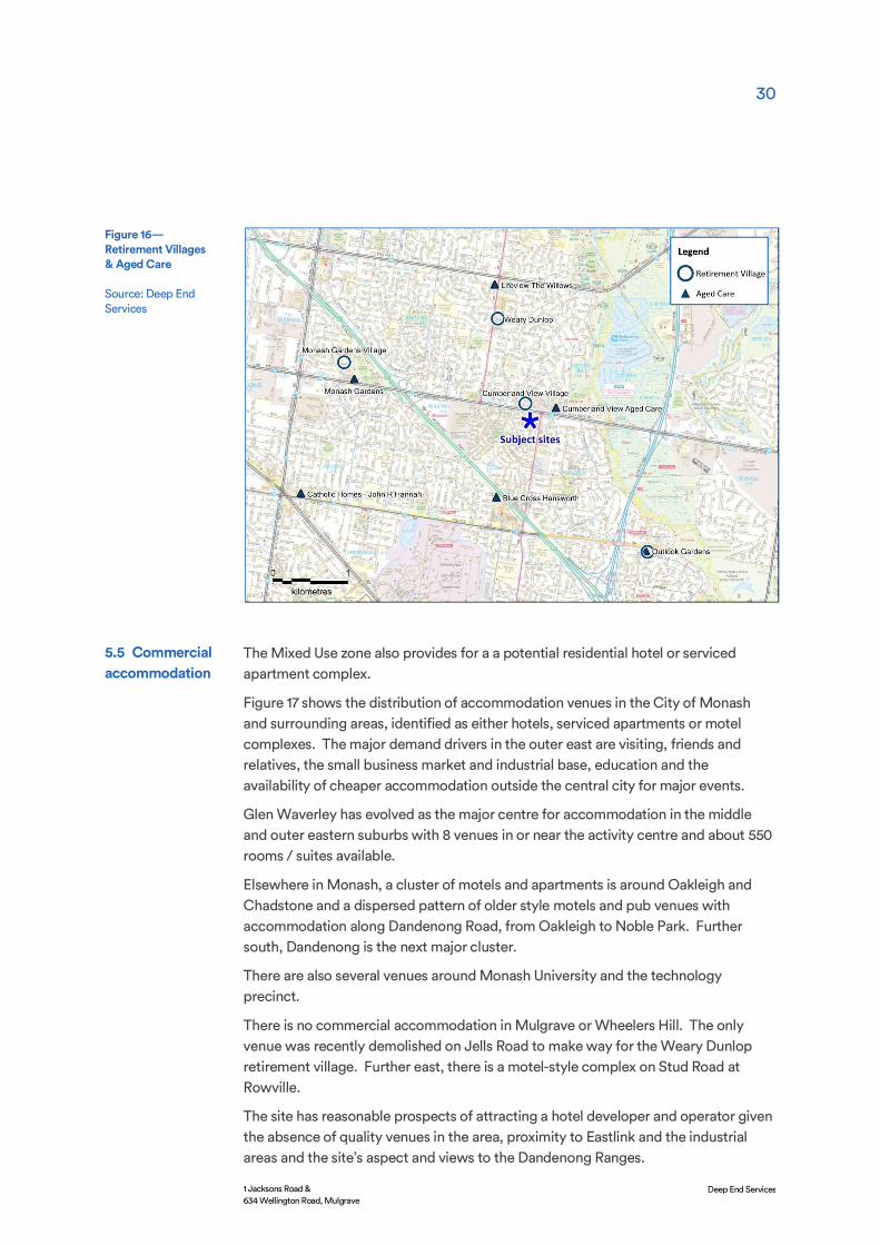
Several older-style retirement villages are present in the area (refer Figure 16) including:
• Cumberland View Village opposite the subject sites. The large 250-villa unit complex with aged care facility was built in 1980. It appears to have a high occupancy level with just 3 units currently for sale.
• Monash Gardens at 355 Wellington Road at Mulgrave. The small 39-unit retirement village and 97-bed residential aged car facility is run by the Royal Freemasons.
• Outlook Gardens Christian Retirement Village on Police Road, North Dandenong. The villa complex with 52 units was built in 1992 and has an aged care facility, recently extended to 95 ageing-in-place beds.
Weary Dunlop Retirement Village is a new apartment-style 3-4 level complex housing 400 residents on Jells Road beside the Wheelers Hill Shopping Centre. This is a contemporary resort style of village built in 2016 with aged car living. It contrasts with the older-style low rise complexes developed on ‘greenfield’ sites during the 1980’s and 90’s.
The subject site lends itself to the development of a ‘vertical’ retirement village or similar accommodation for people downsizing to an apartment. The Mixed Use zone and the DDO provides options for developers to incorporate a more specialised apartment product that caters to the needs of older residents who can utilise potential health / wellness and other facilities on the site.
Our preliminary inquiries also indicate there could be interest in the site from a prospective operator for an aged care complex.
$200,000
$300,000
$400,000
$500,000
$600,000
$700,000
$800,000
$900,000
$1,000,000
$1,100,000
$1,200,000
Median Unit PriceMulgrave Wheelers Hill
$200,000
$300,000
$400,000
$500,000
$600,000
$700,000
$800,000
$900,000
$1,000,000
$1,100,000
$1,200,000
Median House PriceMulgrave Wheelers Hill
Figure 15—Median house & unit prices
Source: APM Pricefinder
30
1 Jacksons Road & 634 Wellington Road, Mulgrave
Deep End Services
The Mixed Use zone also provides for a a potential residential hotel or serviced apartment complex.
Figure 17 shows the distribution of accommodation venues in the City of Monash and surrounding areas, identified as either hotels, serviced apartments or motel complexes. The major demand drivers in the outer east are visiting, friends and relatives, the small business market and industrial base, education and the availability of cheaper accommodation outside the central city for major events.
Glen Waverley has evolved as the major centre for accommodation in the middle and outer eastern suburbs with 8 venues in or near the activity centre and about 550 rooms / suites available.
Elsewhere in Monash, a cluster of motels and apartments is around Oakleigh and Chadstone and a dispersed pattern of older style motels and pub venues with accommodation along Dandenong Road, from Oakleigh to Noble Park. Further south, Dandenong is the next major cluster.
There are also several venues around Monash University and the technology precinct.
There is no commercial accommodation in Mulgrave or Wheelers Hill. The only venue was recently demolished on Jells Road to make way for the Weary Dunlop retirement village. Further east, there is a motel-style complex on Stud Road at Rowville.
The site has reasonable prospects of attracting a hotel developer and operator given the absence of quality venues in the area, proximity to Eastlink and the industrial areas and the site’s aspect and views to the Dandenong Ranges.
Figure 16—Retirement Villages & Aged Care
Source: Deep End Services
5.5 Commercial accommodation

31
1 Jacksons Road & 634 Wellington Road, Mulgrave
Deep End Services
The Quest serviced apartment model would be well-suited to the site with 60-70 rooms and a modest range of on-site amenities.
Other potential uses that could be incorporated into a future site plan include:
• Local level retailing such as a café, convenience store and hairdresser. • Community uses including a library, maternal child and health facility, flexible
space for community use or health-aligned activities associated with a medical centre.
Most of the 15,780 sqm of office and warehouse space at 1 Jacksons Road and 634 Wellington Road is currently vacant. At their peak, both sites probably generated about 300 employment positions however this has now been reduced to about 75 positions.
Under the existing zoning, the prospect of the former employment levels returning is very low given the age of the buildings and infrastructure at 1 Jacksons Road and the expense needed to bring the buildings up to modern standards.
Future employment levels on the site are difficult to predict in the absence of a site plan with land uses, indicative floor areas and possible tenants.
Figure 17—Commercial accommodation
Source: Deep End Services
5.6 Other uses
5.7 Employment benefits

32
1 Jacksons Road & 634 Wellington Road, Mulgrave
Deep End Services
Employment levels are unlikely to return to the peak operating years of the site as a head office and warehouse precinct however there is every likelihood that a combination of residential and some commercial use will increase on-site employment to much higher levels than currently generated by the site.

33
1 Jacksons Road & 634 Wellington Road, Mulgrave
Deep End Services
Local planning policy of the City of Monash supports the retention of industrial and commercial land for employment generating purposes. The two sites at Mulgrave are however of very low strategic value in the context of the industrial land supply in Monash and the land use and economic changes which have occurred since the initial use was conceived.
The larger of the two sites (1 Jacksons Road) was developed 45 years ago when housing estates in Mulgrave and Wheelers Hill were being developed, the Waverley Park football ground was just two years old and the Monash Freeway link from Chadstone to Eumemmering was under construction.
The two sites are now surrounded by housing, forming an isolated industrial node which is removed from other industrial land and out of context with the surrounding residential and retirement village uses.
The early edge-of-city advantages of the site have been eroded as the buildings and facilities have aged and new, more efficient buildings in planned estates with on-site amenities are available elsewhere with equal or better freeway connections. The industrial market in Monash has expanded and consolidated to the technology node around Monash University and the more traditional areas through Oakleigh, Clayton and Springvale.
The loss of 5.3 hectares of Industrial 1 zone is of little significance given the relatively low rate of industrial land development in Monash and the large existing supply of land and buildings.
Conclusions

34
1 Jacksons Road & 634 Wellington Road, Mulgrave
Deep End Services
For new businesses entering or relocating in Monash, there are new industrial buildings available for lease, others readily turning over for re-lease and significant redevelopment opportunities in the older areas where traditional activities have declined and will be displaced by modern buildings more suited to the market. The slow but steady take up of the Monash technology precinct and Caribbean Gardens at Scoresby are better examples of where the market is shifting.
The elevation and eastern aspect of both sites and the new residential interface with Waverley Park, makes the land far more suited to a mixed-use scheme with residential and commercial use.
An ageing population and low diversity of housing choice support higher density housing, aged care and medical uses. These and other on-site uses under the Mixed Use zone can meet the needs of the structural demographic changes occurring in the area and allow residents to move close to their existing networks.
On our analysis, there is a case to support a range of higher density uses permitted under the Mixed Use zone.
In conclusion, there are positive economic and employment benefits in rezoning the site to Mixed Use zone and no material impacts on the effective supply of high quality industrial land in Monash. The change will allow the land to revert to a range of higher and better uses which should deliver a net gain in jobs and economic activity.