Embed Size (px)
Citation preview
C162 | VPA submission to Planning Panels Victoria | 07 September 2016
PART A| Summary of submission 1

C162 | VPA submission to Planning Panels Victoria | 07 September 2016
PART A| Summary of submission 2

C162 | VPA submission to Planning Panels Victoria | 07 September 2016
PART A...............................................................................................................................61. INTRODUCTION..............................................................................................................72. PRELIMINARY MATTERS – PANEL DIRECTIONS................................................................8
2.1. Formal response to all submissions..........................................................................................8
2.2. Proposed changes to documents table.....................................................................................93. WHOLE OF GOVERNMENT POSITION............................................................................104. LOCAL CONTEXT...........................................................................................................10
4.1. Surrounding land use and development.................................................................................11
4.2. Existing zoning.......................................................................................................................14
4.3. Rail services and bus network................................................................................................14
4.4. Open space............................................................................................................................15
4.5. Existing easement & broiler farm buffers...............................................................................165. FRAMEWORK FOR GROWTH AREA DEVELOPMENT.......................................................17
5.1. Background............................................................................................................................17
5.2. Growth Corridor Plans: Managing Melbourne’s Growth.........................................................18
5.2.1. Proposed Industrial Precinct.................................................................................................................19
5.3. Melbourne Strategic Assessment and Biodiversity Conservation Strategy..............................19
5.3.1. Melbourne Strategic Assessment (MSA)...............................................................................................19
5.3.2. Biodiversity Conservation Strategy.......................................................................................................20
5.3.3. Time Stamping Native Vegetation.........................................................................................................21
5.3.4. Habitat Compensation..........................................................................................................................21
5.3.5. Commonwealth Approval for Urban Development under the Melbourne Strategic Assessment.........22
5.3.6. Biodiversity Conservation Strategy Matters Specific to the Mt Atkinson and Tarneit Plains Precinct...22
5.3.7. Local Flora and Fauna Conservation......................................................................................................23
5.4. Plan Melbourne.....................................................................................................................27
5.5. Ministerial Directions.............................................................................................................27
5.5.1. Ministerial Direction 11, Strategic Assessment of Amendments...........................................................27
5.5.2. Ministerial Direction 12, Urban Growth Areas......................................................................................27
5.6. Precinct Structure Planning Guidelines and the Urban Growth Zone......................................27
5.7. State Planning Policy Framework...........................................................................................296. BACKGROUND DOCUMENTS.........................................................................................307. MT ATKINSON AND TARNEIT PLAINS VISION AND PLAN...............................................31
PART A| Summary of submission 3
C162 | VPA submission to Planning Panels Victoria | 07 September 2016
7.1. Vision....................................................................................................................................31
7.2. Description of the Plan...........................................................................................................34
7.2.1 Land Use.................................................................................................................................................34
7.2.2. Town Centres........................................................................................................................................34
7.2.3. Housing.................................................................................................................................................36
7.2.4. Employment..........................................................................................................................................36
7.2.5. Transport Network................................................................................................................................37
Existing local roads..................................................................................................................38
7.2.6. Community Infrastructure.....................................................................................................................38
7.2.7. Open Space...........................................................................................................................................39
7.2.8. Integrated Water Management............................................................................................................40
Sewerage.................................................................................................................................42
Water supply – Potable Water.................................................................................................42
Water supply – Recycled Water...............................................................................................42
7.2.9. Heritage.................................................................................................................................................43
Dry Stone Walls.......................................................................................................................43
Mt Atkinson Homestead..........................................................................................................44
Cobblestone Road....................................................................................................................44
7.2.10. Aboriginal Cultural Heritage................................................................................................................448. INFRASTRUCTURE CONTRIBUTIONS PLAN.....................................................................459. THE AMENDMENT........................................................................................................47
9.1. Changes to planning ordinance in response to submissions....................................................48
Applied Residential Zones........................................................................................................48
10. CONSULTATION..........................................................................................................55
10.1. Consultation and Exhibition.................................................................................................55
PART A| Summary of submission 4
C162 | VPA submission to Planning Panels Victoria | 07 September 2016
APPENDICES:
APPENDIX 1 Unresolved Submission – Mt Atkinson and Tarneit Plains PSP Exhibition Issues Register - September 2016
APPENDIX 2 Changes Matrix with reference to relevant submissions - September 2016
APPENDIX 3 Planning Scheme Ordinance (Track Changed)
APPENDIX 4 Commonwealth Notice of Decision to Endorse the Program to Revise Melbourne UGB-February 2010
APPENDIX 5 Commonwealth Approval for Urban Development – 2013
PART A| Summary of submission 5
C162 | VPA submission to Planning Panels Victoria | 07 September 2016
PART AIntroduction & Amendment overview
PART A| Summary of submission 6

C162 | VPA submission to Planning Panels Victoria | 07 September 2016
1. IntroductionThis submission is made on behalf of the Victorian Planning Authority (VPA).
The VPA is the Planning Authority for Amendment C162 to the Melton Planning Scheme (the Amendment).
The Amendment has been prepared by the VPA in collaboration with the Melton City Council, with the support of the relevant stakeholders, landowners and government agencies.
Formal exhibition of the Amendment commenced on 28 April 2016, and concluded on 30 May 2016. A total of 35 submissions have been received. The VPA has worked extensively with Council, developers, landowners and other stakeholders including State agencies to resolve as many of the submissions as possible. An unresolved submissions table has been provided in Appendix 1.
Note that during preparation of the PSP the ‘VPA’, formally known as the ‘MPA’. However the organisation will be referred to as the ‘VPA’ throughout this Part A submission.
PART A| Summary of submission 7

C162 | VPA submission to Planning Panels Victoria | 07 September 2016
2. Preliminary matters – Panel directions2.1. Formal response to all submissions
A summary of unresolved submissions accompanies this submission, which details the matters which the VPA and submitters consider to be outstanding and require referral to the Panel. A list of changes is also provided which sets out the VPA’s position in response to the matters raised by the submitters and what changes are intended to be made to the documents to address these issues.
Since the exhibition of the proposed amendment, the VPA has meet with submitters to discuss the range of issues. Where possible, officers from the Melton City Council and relevant State Agencies have been present and contributed to the discussions that have led to the resolution of issues. These discussions have resulted in proposed changes to the PSP and associated documents. A comprehensive list of all changes agreed to thus far is provided in Appendix 2.
In its Directions issued on 15 July 2016 the panel requested specific details in relation to the following matters:
Background to the Amendment, in particular how the residential component of the proposed PSP came about. This is provided in Section of this submission.
Strategic assessment. This is provided in Section of this submission.
Identification of the unresolved issues raised in submissions and the VPA’s response. This is provided in Appendix 1 of this submission.
A record of all changes agreed to the Amendment documentation as a result of the issues raised in submissions. This is provided in Section of this submission.
In its Directions issued on 12 August 2016 the Panel specifically sought clarification of the following issues:
Discrepancies between the boundaries of the current ESO2 and ESO5 and the proposed ESO6. This is provided in Section 10 of this submission.
Reference to SUZ3 in the Explanatory Report. This is provided in Section 4.2 of this submission.
Provide an understanding of what is proposed with respect to progressing the Development Contributions Plan/ Infrastructure Contributions Plan. This is provided in Section of this submission.
Provide an understanding of the rationale for using the RGZ as the applied zone for ‘all other land’ in the UGZ. The RGZ is now proposed to be applied together with the GRZ in appropriate locations in response to Council’s submission. This approach is explained in Section of this submission.
Provide a response to the suggestion raised in submissions that an Environmental Significance Overlay (or other overlay) be considered as the mechanism to implement buffers to quarrying and landfill. This is provided in Section 4.2 of this submission.
PART A| Summary of submission 8

C162 | VPA submission to Planning Panels Victoria | 07 September 2016
Advise if a Design and Development Overlay was considered to implement building noise controls near the rail corridor. This is provided in Section of this submission.
Explain how the buffer locations and depths shown in Plan 2 of the PSP have been arrived at, including any relevant legislation, regulations or technical guidelines. This is provided in Section of this submission.
Explain how the boundary of the ‘railway noise amenity area’ shown in Plan 10 of the PSP has been arrived at. This is provided in Section of this submission.
Clarify what is mean at Clause 4.2 of UGZ9 by “transferred at no cost”. This is provided in Section 8 of this submission.
Explain why the GAA (VPA) is proposed as a referral authority in Clause 2.9 of UGZ9. This is provided in Section of this submission.
Confirm that the references in the exhibited Schedule to Clause 66.04 to Clauses 2.10 and 2.11 should be corrected to 2.9 and 2.10 respectively. (please note this is an error in the exhibited ordinance and will be updated).
In its Directions issued on 12 August 2016 the Panel also sought clarification on the following points arising from the package of background documents circulated by the VPA:
Clarification of which version of the PSP the ‘Community Infrastructure and Open Space Needs Assessment’ and the ‘Commercial and Industrial Land Review’ were based, and whether these reports need updating. This is provided in Section and Section of this submission, respectively.
The operational status of the broiler farm in the south west corner of the PSP, and whether it is intended to continue to operate in future. This is provided in Section of this submission.
A brief summary of the flora and fauna conservation issues (including how the Amendment responds to the Melbourne Strategic Assessment and Biodiversity Conservation Strategy requirements) and Aboriginal and post-contact heritage issues identified in background reports. This is provided in Section , Section , Section , and Section of this submission.
A response to the recommendations of the Land Capability Assessment commissioned by the VPA. This is provided in Section 4.1 of this submission.
2.2. Proposed changes to documents table
All changes will be recorded in Appendix 2 – Will update as VPA resolves submissions. If required, any further changes to the documents from what was circulated on the 07 of September 2016 will be tabled on Day 1 of the Panel Hearing.
PART A| Summary of submission 9
C162 | VPA submission to Planning Panels Victoria | 07 September 2016
3. Whole of Government Position
The position presented by the VPA in this submission where possible represents a whole of government submission. The VPA received submissions from a number of State government agencies and departments, and the following submission represents the agreed position of the following:
Department of Environment, Land, Water and Planning (Environment and Heritage areas)
Melbourne Water
Public Transport Victoria
The Department of Economic Development, Jobs, Transport and Resources (Earth and Energy Resources area)
VicTrack
Country Fire Authority.
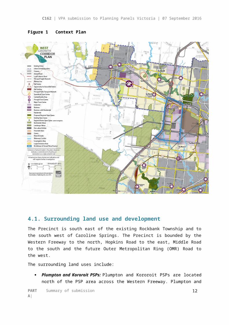
4. Local ContextThe Mt Atkinson and Tarneit Plains Precincts (The Precinct) is located within the Melton growth corridor in the municipality of Melton City Council. Mt Atkinson (PSP 1082) and Tarneit Plains (PSP 1085) have been identified as two distinct Precincts, however in the VPA PSP program, they have been prepared simultaneously as one PSP. A single PSP is appropriate as there is no obvious boundary between the two Precincts. Industrial land use designations will be applied across both Precincts and undertaking a single PSP will allow for a more efficient approach to be undertaken.
The Precinct is located approximately 25 kilometres west of Melbourne’s CBD and covers an area of approximately 1532 hectares of land as illustrated in Figure 1.
PART A| Summary of submission 10
C162 | VPA submission to Planning Panels Victoria | 07 September 2016
Figure 1 Context Plan
4.1. Surrounding land use and development
The Precinct is south east of the existing Rockbank Township and to the south west of Caroline Springs. The Precinct is bounded by the Western Freeway to the north, Hopkins Road to the east, Middle Road to the south and the future Outer Metropolitan Ring (OMR) Road to the west.
The surrounding land uses include:
Plumpton and Kororoit PSPs: Plumpton and Kororoit PSPs are located north of the PSP area across the Western Freeway. Plumpton and Kororoit Precincts will include a Major Town Centre, indoor recreational facilities and the proposed Kororoit Regional Park all of which will be highly accessible for residents and workers within the Precinct.
PART A| Summary of submission 11
C162 | VPA submission to Planning Panels Victoria | 07 September 2016
Rockbank PSP: Rockbank PSP is located west of the Precinct, across the proposed OMR. Rockbank PSP will include a transit-orientated town centre (centred on Rockbank Railway Station) and a range of social infrastructure facilities accessible to residents of the Precinct.
State Significant Quarry: The Deer Park Quarry is an existing hard rock aggregate quarry located across Hopkins Road. It is expected that the quarry has a life span of over 60 years.
To protect the operations of this quarry, the following buffers have been established. The PSP and planning controls set out in the ordinance respond to each of these buffer.
Quarry Sensitive Use Buffer:
The existing Boral Deer Park Quarry is subject to the requirements of EPA publication 1518 Recommended Separation Distances for Industrial Residual Air Emissions (March 2013). This document stipulates that quarrying with blasting activities requires a 500 m buffer from the edge of the extraction limit to the nearest sensitive receptor (this also takes into account potential dust issues). The current extraction limit for the Boral activities extends to 100m from the property boundary. Assuming Hopkins Road is around 20m wide, the buffer encroaches on the eastern edge of the PSP areas by around 380 m. Table 2 in Schedule 9 to the Urban Growth Zone prohibits certain uses within the quarry sensitive use buffer and contains a specific provision to refer applications to the Secretary of the Department administering the Mineral Resources (Sustainable Development) Act 1990.
Quarry Blast Buffer
The Department of Economic Development, Jobs, Transport and Resources (DEDJTR) provided advice in relation to the Boral Quarry as part of a basic assessment to inform the West Growth Corridor Plans which recommended a 200 m buffer in which any buildings would be subject to a risk assessment. A risk assessment was undertaken and DEDJTR recommended that all buildings be excluded from the quarry blast buffer. A Specific Provision has been included in the Schedule 9 to the Urban Growth Zone prohibiting buildings within the quarry blast buffer: The construction of a building, other than those types listed at Clause 62.02-1, on land shown within the Quarry Blast Buffer on Plan 2 in the Mt Atkinson & Tarneit Plains Precinct Structure Plan is prohibited.
Both of these buffers are displayed on Plan 2 of the PSP.
The VPA view is that the approach taken (i.e. the quarry sensitive use buffer and blast buffer to be identified in the PSP Plan set, establishment of prohibited sensitive uses and a referral provision within the Schedule 9 to the Urban Growth Zone for development within the quarry sensitive use buffer and a provision prohibiting all buildings within the quarry blast buffer) are the appropriate mechanisms to prohibit sensitive uses within the quarry sensitive use buffer and to prohibit all buildings within the quarry blast buffer. This approach utilises the land use planning of the PSP and clearly identifies the land impacted by the controls. The use of an overlay in this case would add an additional planning tool not associated with the PSP, and would create confusion when developing and accessing planning permit applications within the quarry buffers. An ESO is also inappropriate as it introduces conflicts
PART A| Summary of submission 12
C162 | VPA submission to Planning Panels Victoria | 07 September 2016
regarding the removal of vegetation, i.e. the PSP in conjunction with 52.17 provides mechanism for the removal/retention of native vegetation.
The Land Capability Assessment Background report by Jacobs makes a series of recommendations for further action. The Panel has requested an update/response to the recommendations set out in the report:
An EAO is proposed to be applied to the two service station sites located in the northern extent of the PSP area
The report recommends additional assessment and ground water/soil sampling on these sites ‘in the near future’. This is impractical because there is no trigger point to require testing where no permit application is being sought.
The report recommends testing of the Nevas Chicken farm prior to redevelopment. This property has been included within the ESA requirement at 3.4 of the UGZ9.
The report recommends testing of 2-50 Meskos Road. This property has been included within the ESA requirement at 3.4 of the UGZ9.
The report recommends testing for low-medium ranked properties. An application requirement has been included for all residential subdivision permit applications (10 lots or more) to provide a hydrogeological assessment and preliminary site assessment. This requirement will address recommendations 5-10 in the report.
Regarding the recommendations relating to noise impact, a requirement relating to rail noise has been included in the UGZ9. Advice from AusNet suggests no buffer is required for the proposed terminal station, furthermore, the surrounding zoning is industrial (i.e. no sensitive uses).
Waste and Resource Recovery Hub of State Importance: This is located to the east, across Hopkins Road, and a landfill operates in the south east of the site.
Chartwell East Precinct: Chartwell East Precinct is directly to the south of the Tarneit Plains Precinct and is identified in the West Growth Corridor Plan as having a future industrial use
Derrimut Fields Precinct: Derrimut Fields Precinct is to the south east of the Tarneit Plains Precinct and is identified in the West Growth Corridor Plan as having a future industrial use and is the proposed location for the future Western Interstate Freight Terminal (WIFT).
Green Wedge Zone and Western Grasslands Reserve: Land zoned Green Wedge abuts the OMR Public Acquisition Overlay to the west of the Precinct. Beyond the Green Wedge Zone are the Western Grasslands Reserve designated to protect the largest remaining concentration of volcanic plains grasslands in Australia and retain other habitat types, including ephemeral wetlands, waterways, Red Gum swamps, rocky knolls and open grassy woodlands. These reserves also provide habitat for a large number of State and Commonwealth listed threatened and rare species, in particular the Golden Sun Moth and Spiny Rice-flower, the Striped Legless Lizard and the Plains Wanderer
PART A| Summary of submission 13

C162 | VPA submission to Planning Panels Victoria | 07 September 2016
4.2. Existing zoning
The following are the existing zones within the Mt Atkinson and Tarneit Plains Precinct:
Urban Growth Zone
Rural Conservation Zone
Farming Zone
Special Use Zone (Schedule 3 Terminal Stations)
Urban Floodway Zone (refer Section )
Public Use Zone
4.3. Rail services and bus network
Currently, there is one bus route that runs limited services along the Western Freeway between Melton and Melbourne. The provision of a future bus capable road network including along the future proposed Principal Public Transport Network (PPTN) is proposed by the PSP.
Fixed rail public transport is available via V/Line services along the Ballarat-Southern Cross Line. It traverses the northern part of the Precinct and serves the existing Rockbank train station, which is located 4.5 kilometres west of the PSP area. The future Caroline Springs station is located 8.5 kilometres east of the Precinct and will provide access to V/Line services on the Ballarat Line from Southern Cross. A potential future station at Mt Atkinson has been identified for inclusion following future upgrades to the Melbourne-Ballarat railway line.
Provision 3.5 of Schedule 9 to the Urban Growth Zone- Railway Noise Attenuation requires an application for use or development within the ‘railway noise amenity area’ on Plan 10 of the PSP to be accompanied by an acoustic assessment report.
VPA commissioned a Potential Acoustic Impact Assessment to:
Assess potential acoustic impacts of the Melton Line Upgrade Project to future residential developments
Determine the land area expected to exceed the investigation thresholds, so that a planning control could be created for this area.
From the assessment, the PSP identifies a railway noise amenity area adjacent to the Melton rail corridor. Any application for development within the railway noise amenity area must carry out an acoustic assessment in accordance with the requirements of Schedule 9 to the UGZ.
The Potential Acoustic Impact Assessment identified investigation thresholds in relation to internal bedroom noise and the acoustic assessment report must include recommendation for noise attenuation measures designed to ensure internal bedroom noise levels will not exceed these thresholds as well as recommendations to limit the impact of railway noise and a design response. Noise attenuation measures are designed to ensure internal bedroom noise levels will not exceed 65dBLAmax and 40dBLAeq, 8h for the night period from 10pm to 6am. This is consistent with the levels required for Section 2 of the Regional Rail Link project.
PART A| Summary of submission 14

C162 | VPA submission to Planning Panels Victoria | 07 September 2016
A Design and Development Overlay approach was adopted for Section 2 of the Regional Rail Link project to ensure noise attenuation measures were implemented. However, the Mt Atkinson and Tarneit Plains PSP proposes to use the same approach supported by Panel in Rockbank PSP (with some rewording as applicable to the Mt Atkinson PSP). In the PSP context it is clearer to have the amenity area shown in the PSP document than located in a separate overlay.
4.4. Open space
State / Commonwealth Conservation Area
The development of the precinct will establish a conservation area network comprising an area of approximately 144.14 hectares under the State/Commonwealth agreed Biodiversity Conservation Strategy (BCS). This area comprises conservation area for Nature Conservation and Open Space and is located near the Western Grasslands. In accordance with the requirements of the BCS, this area will provide opportunities for only limited recreational activities.
The Meskos Road Reserve
The Meskos Road environmental reserve is an unused road reserve, currently managed by Melton City Council. The reserve currently contains two orchid species including the Common Onion Orchid and the Forest Sun Orchid. Although these orchid species are not listed at the State or Commonwealth level, there are very few large natural orchid populations that remain in the Plains Grassland west of Melbourne. Therefore, the Meskos Road grassland should be considered to be of local significance.
Sports reserves
The proposed sporting reserves are to be provided adjacent to waterways and co-located with education and community facilities where possible. The sports reserves will be configured to Council’s general sporting reserve requirements and cater for high participation sports, potentially including Australian Rules football or soccer, cricket and tennis, as well as hard courts for netball and basketball. They will be located within convenient walking distance (1km) of 95% of all dwellings.
Local parks
Local parks will be equitably distributed across the PSP area, maximising access by the local community and generating high amenity. Local parks should be delivered in sizes ranging from 0.2 hectares to 2 hectares, cater for a diverse range of functions (i.e. gathering spaces, walking pets, linear connections, community focal points), and be located within convenient walking distance (400 metres) of 95% of all dwellings.
The PSP will have permeable access to open space via a network of linear paths that follow waterway corridors, road reserves and linear open space, and connect to regional open space including the Western Grasslands Reserve, the proposed Kororoit Regional Park, and a path network along the future OMR, Western Freeway and the Melton Rail Corridor.
PART A| Summary of submission 15
C162 | VPA submission to Planning Panels Victoria | 07 September 2016
Mt Atkinson Volcanic Cone
The Mt Atkinson volcanic cone is the central feature of the PSP area. Mt Atkinson is one of a number of volcanic cones which define the region, and the PSP will ensure it becomes a popular destination to enjoy views to the Macedon Ranges, the Melbourne CBD and Port Phillip Bay. Mt Atkinson volcanic cone and the associated rural conservation zone land will be retained as open space. The upper slopes of Mt Atkinson will feature restored grassland and retained rocky outcrops and will provide an understanding of its Aboriginal cultural significance, while playing fields and casual play areas will be located on its lower levels.
The land that is currently zoned Rural Conservation Zone relating to the Mt Atkinson Volcanic Cone Reserve and associated environmental significance overlay and significant landscape overlay has been altered slightly to allow the delivery of a coherent road network abutting the Mt Atkinson Volcanic Cone. PSP Figure 1 identifies the area to be removed and the area to be added. The slight reductions and additions do not result in any net change to the rural conservation zone and associated overlays or impact on the values to be protected by the zoning and overlays. This slight alteration explains the difference between the deleted overlays and the amended overlays to be introduced by the Planning Scheme Amendment.
4.5. Existing easement & broiler farm buffers
High pressure gas transmission 'pipeline measurement length’:
APA owns the licence for the high pressure gas transmission pipelines and associated easements which run through the PSP area. The Deer Park to Sunbury pipeline (150mm diameter) and the Truganina to Plumpton pipeline (500mm diameter) run parallel to Hopkins Road along the eastern boundary of the PSP area. The Brooklyn to Lara pipeline (500mm diameter) and the Brooklyn to Ballan pipeline (200mm diameter) run parallel to Middle Road in the south of the PSP area. The greater of the measurement lengths of each pipeline pair (ie along Hopkins Rd and along Middle Rd) is 571m and is shown on Plan 12 in the PSP. The measurement length of the Deer Park to Sunbury pipeline along Hopkins Rd is 140m.
The pipeline owner is required to undertake a ‘Safety Management Study’ (SMS) at regular intervals and when there is a change of land use along a pipeline, to assess the risk to the pipeline during and after future development of the area. The SMS workshop identified threats of only ‘low risk’. More information is provided in the Mt Atkinson and Tarneit Plains PSP background report if required.
Electricity easement
Powercor is the supply authority for the PSP area. As Powercor’s existing zone substations begin to approach maximum capacity, a new ‘Rockbank East’ zone substation will be located in proximity to the Kororoit Precinct to service the PSP. Upgrades specific for development that is not considered a network upgrade will need to be developer funded. Developers will need to fund internal works and relocate existing overhead lines underground where required in the PSP.
PART A| Summary of submission 16
C162 | VPA submission to Planning Panels Victoria | 07 September 2016
There is an existing SP Ausnet-owned 154m wide high voltage transmission easement located within the PSP area, containing two 500 kV transmission lines. PSP Figure 6 and associated Table 6 have been developed to identify the potential use and development of the easement.
The easement was a constraint on the design of the PSP as the Department of Education and Training states that government schools cannot be located within 400m of the easement.
Proposed electrical terminal station
SP-Ausnet is the electricity transmission authority and has planned new terminal stations at Deer Park (DPTS) and Truganina (TTS). The Truganina terminal station lies with the Tarneit Plains Precinct at the intersection of Mt Atkinson Road and Riding Boundary Road. It will provide both 500kV to 220kV and 220kV to 66kV. Easements and indicative circuits are shown in Plan 12 in the PSP. The land required for this terminal station is currently zoned Schedule 3 to Clause 37.01 Special Use Zone (SUZ) and this zoning will be retained. The Amendment inserts Schedule 11 to Clause 37.01 Special Use Zone (SUZ) into the Melton Planning Scheme and rezones part of the Precinct to SUZ11 to encourage a greater range of industrial uses and the development of land in the easement generally in accordance with the Mt Atkinson & Tarneit Plains PSP.
Broiler Farm
The existing broiler farm on PSP Property 58 (the Nevas Chicken Farm) recently sought an expansion of its use on the site. The expansion of the use sought to increase bird numbers at the existing farm from 160,000 to 240,000 chickens. Council is currently considering the application. The existing buffers of the broiler farm are illustrated in PSP Plan 2 and are not considered to cause significant impacts on the PSP due to the surrounding conservation and industrial uses proposed.
5. Framework for Growth Area DevelopmentGrowth area planning is guided by a hierarchy of plans prepared by state and local governments at a municipal or precinct level. The hierarchy of plans provide the framework for growth area planning and development and seek to achieve the objectives of the State Planning Policy Framework.
5.1. Background
The Urban Growth Boundary (UGB) designates the long-term limits of urban development and where non-urban values and land uses should prevail in metropolitan Melbourne.
The UGB first came into effect in 2002 in conjunction with the release of Melbourne 2030. This plan established the long term plan for land within the UGB, including the intention to review the boundary at an appropriate time in the future.
Melbourne at 5 Million in 2008 and the subsequent Delivering Melbourne’s Newest Sustainable Communities Program Report 2009 facilitated the expansion of the UGB in 2010. It was at this time that the land which forms the Mt Atkinson & Tarneit Plains Precinct was brought into the UGB.
Work on Melbourne’s Growth Corridor Plans began in 2011, with consultation at the end of the same year. These plans were formally approved by the Minister of Planning in mid-2012. These are discussed in more detail below.
PART A| Summary of submission 17
C162 | VPA submission to Planning Panels Victoria | 07 September 2016
5.2. Growth Corridor Plans: Managing Melbourne’s Growth
The Growth Corridor Plans: Managing Melbourne’s Growth (GCP) are high level integrated land use and transport plans that provide a strategy for the development of Melbourne’s growth corridors over the next thirty to forty years.
These plans will guide the delivery of key housing, employment and transport infrastructure and open space in Melbourne’s newest metropolitan suburbs.
The GCP identifies:
The long term pattern of land use and development;
Committed transport networks as well as network options for investigation;
Committed regional open space networks as well as investigation sites; and
Opportunities for creating green corridors.
The GCP informs the development and review of local planning schemes and the preparation of future strategies, structure plans and other planning tools. They also provide a strategic basis for infrastructure and service planning as well as sequencing of land release.
The preparation of PSPs is the primary vehicle for the implementation of the GCP.
The West Growth Corridor Plan covers Melbourne’s western corridor and includes large areas of the Melton City Council and Wyndham City Council. The Mt Atkinson and Tarneit Plains Precinct lies within the West GCP.
The West GCP outlines key existing and future infrastructure items in direct proximity to the precinct that will provide direct or flow-on benefits to future residents in the area, including:
Roads and public transport;
Planning for connected high capacity public transport corridor with the potential for rail;
Bus capable roads within the precinct for local bus routes;
E6 transport corridor / Outer Metropolitan Ring road;
Employment;
Community, health and education facilities;
New major and specialised town centres are identified at Mt Atkinson, Plumpton, Rockbank North, Rockbank South, Tarneit, Sayers Road and Wydham Vale.
Future Western Industrial Precinct.
Open space and biodiversity;
Protection of the Kororoit Creek via the Biodiversity Conservation Strategy;
Metropolitan Trail Network.
The West Growth Corridor Plan (2012) identifies the precincts as industrial, business and business with residential. The PSP has refined the uses as shown in the Corridor Plan, as follows:
PART A| Summary of submission 18

C162 | VPA submission to Planning Panels Victoria | 07 September 2016
The Hopkins Road Specialised Town Centre has moved to the west of the location proposed in the West Growth Corridor Plan in response to potential impacts from the high pressure gas pipeline measurement length and to allow for the development of a potential future rail station close to the Specialised Town Centre.
In response to the potential for the development of a train station, the land use north of the rail corridor has partially changed to commercial and mixed use (from industrial) to capitalise on the potential station development.
The designation of ‘business with residential’ has been refined to propose mixed use and commercial 1 and 2 zoning south of the rail line, and predominantly residential uses around the Mt Atkinson volcanic cone.
The southern section of the Mt Atkinson Precinct is identified in the Corridor Plan as industrial. The PSP establishes a section of this land as residential to allow for the development of a critical residential mass to support two community hubs providing council community facilities, open space and government primary schools within the precinct (one either side of the volcanic cone open space). This reconfiguration of land uses also establishes the high transmission electricity easement as a logical interface with the industrial land in Tarneit Plains along with the application of the industrial 3 zone. The Department of Economic Development, Jobs, Transport and Resources (DEDJTR) did not object to this change of land use at agency consultation nor at public exhibition.
The PSP retains commercial and industrial land use designations abutting Hopkins Road consistent with the West Growth Corridor Plan.
5.2.1. Proposed Industrial Precinct
Plan Melbourne 2014 and the Growth Corridor Plan identifies 1,510 (gross) hectares of land for the future State significant industrial precinct. It will be an extension to the Western Industrial Node, which would be accessible by a new freeway link between the Western Ring road and the OMR. The industrial precinct will have ready access to rail freight, and could accommodate a major new freight terminal to enable the transfer of interstate freight between road and rail from the Ports of Melbourne and Geelong to other parts of Australia.
5.3. Melbourne Strategic Assessment and Biodiversity Conservation Strategy
5.3.1. Melbourne Strategic Assessment (MSA)
In June 2009, the Victorian and Commonwealth governments agreed to undertake a strategic assessment of the Victorian Government's urban development program Delivering Melbourne’s Newest Sustainable Communities.
The program involves urban development in four growth corridors and in 28 existing urban precincts, as well as the development of a Regional Rail Link Corridor between Werribee and Deer Park and the Outer Metropolitan Ring/E6 Transport Corridor.
The areas included in the program and covered by the MSA are:
PART A| Summary of submission 19

C162 | VPA submission to Planning Panels Victoria | 07 September 2016
Areas added to the Urban Growth Boundary by planning scheme amendment VC68 (the 2010 Urban Growth Boundary) – this includes the Mt Atkinson and Tarneit Plains Precinct.
Areas in the Outer Metropolitan Ring/E6 Transport Corridor and the Regional Rail Link corridor
Areas in the existing 28 urban precincts within the 2005 Urban Growth Boundary.
The Melbourne Strategic Assessment (MSA) evaluates the impacts of the Victorian Government’s urban development program for Melbourne on matters of national environmental significance (MNES) protected under the Commonwealth Environment Protection and Biodiversity Conservation Act 1999 (EPBC Act). It also establishes conservation measures to mitigate these impacts. The MSA required the Victorian Government to make commitments to the Commonwealth Government in relation to conservation outcomes and measures to protect these MNES, which are outlined in Delivering Melbourne’s Newest Sustainable Communities Program Report 1 (the Program Report).
The MSA delivers a single environmental approval for both Victorian and Commonwealth environmental regulation for the first time. The program represents a significant cost saving in the order of $500 million over the expected 30- year period of development, primarily arising from the reduction in holding costs, avoiding opportunity cost associated with land take in the growth corridors and a reduction in information costs and administrative burden.
The MSA commitments included the preparation of the Biodiversity Conservation Strategy (BCS) which describes the overarching strategy for the protection of biodiversity within Melbourne’s growth corridors. The BCS sets out the detailed conservation measures required for Victoria to satisfy the commitments made to the Commonwealth Government under the MSA and meet State requirements for biodiversity under the Victoria planning schemes. These conservation measures will be funded using a cost recovery model. The program will generate incomes of close to $1 billion over the next 40 years towards the delivery of the program.
A copy of the Commonwealth notice to endorse the program to revise the Melbourne Urban Growth Boundary as signed in February 2010 can be found at Appendix 4.
5.3.2. Biodiversity Conservation Strategy
The approved Biodiversity Conservation Strategy (BCS) is the overarching strategy for the protection of biodiversity in the growth corridors and finalises the planning for biodiversity under the Melbourne Strategic Assessment.
The BCS sets out all the conservation measures required to satisfy the commitments to the Commonwealth Government and to meet state biodiversity requirements.
The purpose of the BCS is to:
Inform and guide the preparation of the Growth Corridor Plans
Outline how the conservation outcomes for MNES in the Program Report will be achieved spatially within the growth corridors and how impact on the matters of national significance will be mitigated
Identify land within the growth corridors that is required to be protected due to the sub-regional species strategies and the prescriptions for matters of national environmental significance
PART A| Summary of submission 20

C162 | VPA submission to Planning Panels Victoria | 07 September 2016
Identify how areas set aside for conservation purposes will be managed; and
Identify how mitigation measures will be implemented.
Essentially, the BCS identifies those MNES that must be protected and conserved and those areas that can be removed to enable the urban expansion of Melbourne.
5.3.3. Time Stamping Native Vegetation
The time-stamping project captured and “time-stamped” native vegetation information to establish a native vegetation dataset and maps showing the type, extent and condition of all native vegetation in the growth corridors. This information has been used, along with information on threatened species habitat from the conservation strategies, to calculate habitat compensation obligations and native vegetation offsets for urban development.
The time-stamping data applies to the four growth corridors in the expanded 2010 Urban Growth Boundary and 16 of the existing 28 urban precincts in the 2005 Urban Growth Boundary covered by the BCS.
The Victorian Government undertook extensive consultation as part of the time-stamping project; providing opportunities for landowners to review the Department of Environment Land Water and Planning’s (DELWP) understanding of the native vegetation on their property and submit changes for consideration.
The report Time-stamping native vegetation data – Public Consultation 2010 – 12 Final Report (May 2013) outlines the growth corridor native vegetation survey, the public consultation process and explains how the data set was finalised.
5.3.4. Habitat Compensation
The habitat compensation scheme enables collection of offsets for the removal of native vegetation and loss of habitat for threatened species protected under the EPBC Act on land developed for urban uses within Melbourne’s growth corridors.
The introduction of a flat fee for native vegetation removal and loss of habitat for threatened species affected by urban development in Melbourne’s growth corridors provides a streamlined and consistent offset framework for landowners to make informed decisions about the costs of development. It also means that landowners can meet their offset obligations with an in-lieu payment and will not be required to undertake assessments or enter into negotiations. The availability of staged fee payments acknowledges the scale and sequencing of development in the growth corridors and responds to the request from industry for this flexible payment option to be made available.
The document named Habitat Compensation under the Biodiversity Conservation Strategy August 2011 provides further details of the cost recovery model, the required fees and the obligations and means by which the habitat compensation system operates.
PART A| Summary of submission 21

C162 | VPA submission to Planning Panels Victoria | 07 September 2016
5.3.5. Commonwealth Approval for Urban Development under the Melbourne Strategic Assessment
On 5 September 2013 the Commonwealth Minister for the Environment approved all actions associated with urban development in the west growth corridor as described in the BCS. Importantly this approval was issued subject to conditions. Condition 4 of the approval is pertinent to Conservation Areas 7 and 8, and states that persons must not take any actions that would cause or otherwise facilitate a change in the boundaries of these conservation areas unless agreed by the Commonwealth Minister for the Environment.
The Approval for urban development can be found at Appendix 5.
5.3.6. Biodiversity Conservation Strategy Matters Specific to the Mt Atkinson and Tarneit Plains Precinct
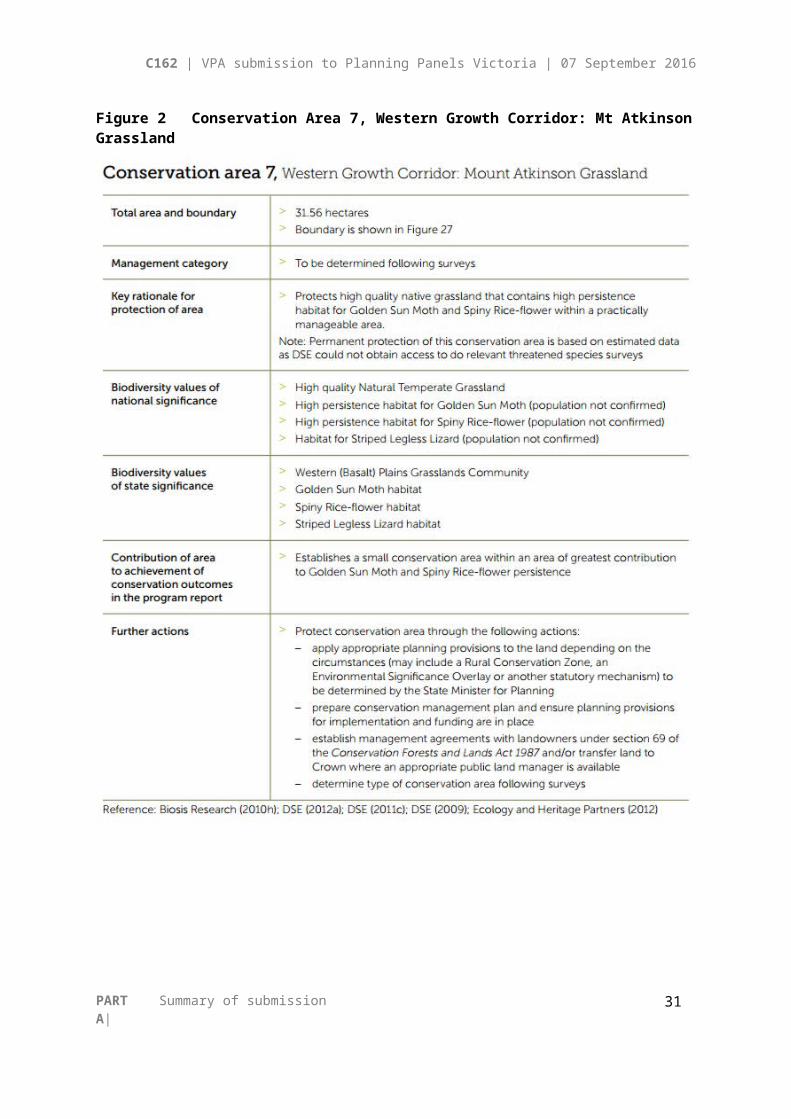
The Biodiversity Conservation Strategy (BCS) for Melbourne’s Growth Corridors (DEPI, June 2013) identified two conservation reserves with the Mt Atkinson and Tarneit Plains Precinct – Conservation Area 7 and Conservation Area 8.
In the BCS, the table on page 64 and located in Figure 2 below, describes Conservation Area 7. It is approximately 31.56 hectares. The key rationale is to protect high quality native grassland that contains high persistence habitat for Golden Sun Moth and Spiny Rice-flower within a practically manageable area.
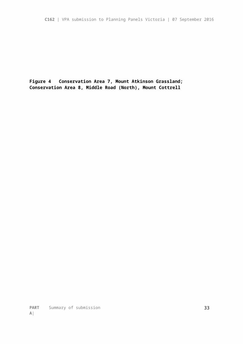
Conservation Area 8 is approximately 112.58 hectares in size and its key rationale is to protect high quality native grassland that contains high persistence habitat for Golden Sun Moth within a practically manageable area. The table within the BCS (DEPI, June 2013, on page 65 and located in Figure 4 below), describes Conservation Area 8 and provides further details.
The BCS listed further actions as per the tables in Figure 2 and Figure 3, in summary as follows:
Determine appropriate zoning and overlays
PSP response: retention of the existing Rural Conservation Zone and the Environmental Significance Overlay (simplified to retain a single ESO 6 across the PSP to replace/ refine ESO2 and ESO5 within the PSP)
Clarify the management category of both Conservation Area 7 (CA7) and Conservation Area 8 (CA8)
PSP response:
VPA commissioned surveys to be undertaken for the affected parcels (CA7 comprises a single parcel and CA8 comprises four parcels of land).
CA7: no access could be gained to the site so surveys could not be undertaken and the management category could not be clarified. DELWP will seek to complete this work in future.
CA8: access was gained to three of the four land parcels, and surveys were undertaken. Surveys determined that high quality native grassland and large areas of the EPBC Act listed
PART A| Summary of submission 22

C162 | VPA submission to Planning Panels Victoria | 07 September 2016
ecological community NTGVVP were present, providing potential habitat for Golden Sun Moth, Striped Legless Lizard and other State and regionally significant flora and fauna species. Therefore the area is recommended to be managed primarily for nature conservation.
Prepare Conservation Concept Plans
PSP response:
Conservation Concept Plans for CA7 and CA8 were prepared in accordance with the Guidance Note: Implementing the Biodiversity Conservation Strategy for Melbourne’s Growth Corridors (February 2015).
DELWP will establish management agreements with landowners in the future.
5.3.7. Local Flora and Fauna Conservation
The report Targeted Flora Searches: Ferris Road Melton South and Meskos Road Rockbank prepared for the Melton City Council identified two orchid species including the Common Onion Orchid and the Forest Sun Orchid, within the Meskos Road reserve. The road is an unused road reserve in crown land, managed by council. The PSP seeks to retain the sections of the reserve containing clusters of orchids in a local conservation reserve, with an appropriate interface between the reserve and the uses proposed within the town centre.
Further, the Mt Atkinson volcanic cone is one of a number of volcanic cones which define the landscape of the region. Mt Atkinson volcanic cone and the associated Rural Conservation Zone land will be retained as open space. The upper slopes of Mt Atkinson will feature restored grassland and retained rocky outcrops and will provide an understanding of its Aboriginal cultural significance, while playing fields and casual play areas will be located on its lower levels.
In addition to the BCS Conservation Areas, the Meskos Road conservation reserve and Mt Atkinson volcanic cone reserve, there are also opportunities to enhance ecological values through the regeneration of remnant native vegetation in local parks and the provision of stormwater treatment wetlands which will provide additional habitat for a range of fauna species.
PART A| Summary of submission 23

C162 | VPA submission to Planning Panels Victoria | 07 September 2016
Figure 2 Conservation Area 7, Western Growth Corridor: Mt Atkinson Grassland
PART A| Summary of submission 24

C162 | VPA submission to Planning Panels Victoria | 07 September 2016
Figure 3 Conservation Area 8, Western Growth Corridor: Middle Road (North), Mt Cottrell
PART A| Summary of submission 25
C162 | VPA submission to Planning Panels Victoria | 07 September 2016
Figure 4 Conservation Area 7, Mount Atkinson Grassland; Conservation Area 8, Middle Road (North), Mount Cottrell
PART A| Summary of submission 26
C162 | VPA submission to Planning Panels Victoria | 07 September 2016
PART A| Summary of submission 27
C162 | VPA submission to Planning Panels Victoria | 07 September 2016
5.4. Plan Melbourne
Plan Melbourne: Metropolitan Planning Strategy, an adopted government policy document released by the Victorian Government in May 2014, outlines the provision of necessary infrastructure and support for development proposed by the West Growth Corridor Plan as part of its discussion regarding Melbourne’s Western Sub-region. The Plan Melbourne Refresh Discussion Paper released in October 2015, addresses key issues of housing supply, diversity and affordability, employment, climate change and will reflect current transport network priorities.
5.5. Ministerial Directions
The amendment complies with the Ministerial Directions applicable to the amendment as detailed in the explanatory report. More broadly, the amendment complies with the following Ministerial Directions relating to the preparation of an amendment within the urban growth areas including:
5.5.1. Ministerial Direction 11, Strategic Assessment of Amendments
The Amendment has been strategically assessed in accordance with the assessment criteria set out in Ministerial Direction 11.
The amendment will implement the objectives of planning in Victoria by providing for the fair, orderly, economic and sustainable use of land identified for urban purposes.
The amendment has addressed environmental effects, as the pattern of land use and development was guided by studies of the area relating to flora and fauna, flooding and drainage.
The amendment has addressed social and economic effects. It is expected to have a positive social and economic effect through the provision of additional housing and community facilities, as well as the creation of local employment opportunities.
5.5.2. Ministerial Direction 12, Urban Growth Areas
This Direction applies to the preparation of any planning scheme amendment that provides for the incorporation of a PSP in the scheme or the introduction of, or changes to, provisions in a schedule to the Urban Growth Zone (UGZ). Therefore, the Direction applies to the Amendment.
The Direction provides that the Amendment must implement the Growth Area Corridor Plan relevant to the land and must be in accordance with applicable Precinct Structure Plan Guidelines.
5.6. Precinct Structure Planning Guidelines and the Urban Growth Zone
On 7 October 2009 the Minister for Planning launched the Precinct Structure Planning Guidelines. These Guidelines replace the draft 2006 version and provide a tool for designing and delivering better quality communities in growth areas. They set out the key objectives of growth area planning and include a step by step guide on how to achieve the identified objectives.
The overarching objectives for PSPs are set out in the guidelines.
They are to:
Establish a sense of place and community;
Create greater housing choice, diversity and affordable places to live;
PART A| Summary of submission 28

C162 | VPA submission to Planning Panels Victoria | 07 September 2016
Create highly accessible and vibrant activity centres;
Provide local employment and business activity;
Provide better transport choices;
Respond to climate change and increase environmental sustainability;
Deliver accessible, integrated and adaptable community infrastructure.
The explanatory report details how the amendment meets each objective of the Precinct Structure Planning Guidelines.
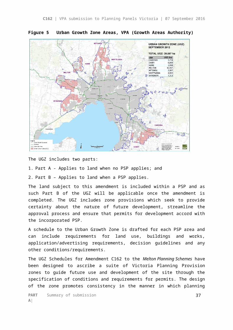
The UGZ applies to land that has been identified for future urban development within the UGB (Figure 5). The UGZ sits within the suite of zones within the Victorian Planning Provisions. It has been specifically designed to implement an incorporated PSP and ensure that future development accords with the approved PSP.
Figure 5 Urban Growth Zone Areas, VPA (Growth Areas Authority)
The UGZ includes two parts:
1. Part A - Applies to land when no PSP applies; and
2. Part B – Applies to land when a PSP applies.
The land subject to this amendment is included within a PSP and as such Part B of the UGZ will be applicable once the amendment is completed. The UGZ includes zone provisions which seek to provide certainty about the nature of future development, streamline the approval process and ensure that permits for development accord with the incorporated PSP.
PART A| Summary of submission 29

C162 | VPA submission to Planning Panels Victoria | 07 September 2016
A schedule to the Urban Growth Zone is drafted for each PSP area and can include requirements for land use, buildings and works, application/advertising requirements, decision guidelines and any other conditions/requirements.
The UGZ Schedules for Amendment C162 to the Melton Planning Schemes have been designed to ascribe a suite of Victoria Planning Provision zones to guide future use and development of the site through the specification of conditions and requirements for permits. The design of the zone promotes consistency in the manner in which planning authorities deal with land use issues and ensures that the zone implements the State Planning Policy Framework.
The amendment will introduce the Urban Growth Zone Schedule 9 to the Melton Planning Scheme and apply it to the amendment area. The amendment will also introduce the Development Contributions Plan Overlay Schedule 16 (DCPO9) to the Melton Planning Scheme. The Planning Scheme ordinance has been structured in such a way that the ultimate translation to conventional Victorian Planning Provision zones can occur in a timely and efficient manner once the land has been developed.
Should the PSP’s be gazetted prior to the new format infrastructure contributions levy system (ICP) framework being finalised, the DCPO has been included as a trigger to require permit applicants to enter into an agreement with the Council to deliver related infrastructure identified through the Precinct Infrastructure Plan (PIP). This issue is dealt with in Section .
A copy of the latest version of the Schedule 9 to the Urban Growth Zone can be found at Appendix 3.
5.7. State Planning Policy Framework
The State Planning Policy Framework (SPPF) ensures that the objectives of section 4 of the Planning and Environment Act 1987 are implemented through appropriate land use development by addressing environmental, social and economic factors to achieve sustainable development.
The relevant clauses and provisions of the SPPF are:
Clause 11 – Settlement;
Clause 12 – Environment and Landscape Values;
Clause 16 – Housing;
Clause 17 – Commercial;
Clause 18 – Transport;
Clause 19 – Infrastructure.
The amendment achieves the objectives of the above clauses by:
Providing a plan for the zoned land suitable for housing, commercial, recreation, open space and council infrastructure opportunities.
Planning for accessibility via a range of transport nodes to key destinations in the surrounding neighbourhoods.
PART A| Summary of submission 30
C162 | VPA submission to Planning Panels Victoria | 07 September 2016
Facilitating development of a range of housing densities that will cater to a range of household types and income levels.
Responding to the environmental qualities of the district through the retention and enhancement of the Mount Atkinson Volcanic Reserve with surrounding pedestrian and bike path linkages.
6. Background DocumentsThe amendment is supported by a number of background and environmental reports.
The following reports were commissioned throughout the stages of the PSP:
Mt Atkinson and Tarneit Plains – Community Infrastructure and Open Space Needs Assessment – July 2016 – prepared by VPA
Mt Atkinson (PSP1082) and Tarneit Plains (PSP1085) – Tree Assessment – Meskos Rd – Ecology & Heritage Partners – November 2014
Mt Atkinson (PSP1082) Post Contact Heritage Report – Ecology and Heritage Partners – March 2015
Mt Atkinson (PSP1082) and Tarneit Plains Conservation Area 8 and Supporting Information -Ecology and Heritage Partners - April 2015
Mt Atkinson (PSP1082) and Tarneit Plains Conservation Area 7 and Supporting Information -Ecology and Heritage Partners - April 2015
Mt Atkinson (PSP1082) and Tarneit Plains (PSP1085) PSP – Commercial and Industrial Land Review – 22 April 2015
Melton Rail Corridor- Potential Acoustic Impact Assessment- Arup-March 2016
Mt Atkinson (PSP1082) and Tarneit Plains (PSP1085) PSP – Land Capability Report – Jacobs – 2 July 2015
Mt Atkinson (PSP1082) and Tarneit Plains~085) PSP Utility Servicing and Infrastructure Assessment Report- September 2014
Mt Atkinson (PSP1082) – Aboriginal Heritage Impact Assessment – Ecology and Heritage (redacted copy) – October 2015
Tarneit Plains (PSP1085) – Aboriginal Heritage Impact Assessment – Ecology and Heritage (redacted copy) – October 2015
Mt Atkinson (PS1082) and Tarneit Plains (PSP1085) Transport Modelling Assessment Jacobs- July 2016
These background studies informed the pre-planning of the PSP.
Copies of these reports have been previously provided to Planning Panels Victoria on 4/8/16 and have been available to all parties and the public on the VPA website as they have become available, prior to the formal exhibition process.
PART A| Summary of submission 31

C162 | VPA submission to Planning Panels Victoria | 07 September 2016
7. Mt Atkinson and Tarneit Plains Vision and Plan7.1. Vision
The PSP outlines and manages the transition of the Mt Atkinson and Tarneit Plains area from an historic agricultural settlement, to a thriving part of Metropolitan Melbourne. The PSP recognises and enhances the local heritage, landscape and environmental values of the area while delivering a variety of housing and employment opportunities, and community facilities in the heart of the West Growth Corridor.
The Mt Atkinson volcanic cone is the central feature of the PSP area. Mt Atkinson is one of a number of volcanic cones which define the region, and the PSP will ensure it becomes a popular destination to enjoy views to the Macedon Ranges, the Melbourne CBD and Port Phillip Bay. The upper slopes of Mt Atkinson will feature restored grassland and retained rocky outcrops and will provide an understanding of its Aboriginal cultural significance, while playing fields and casual play areas will also be located within the reserve.
With its excellent transport connections Mt Atkinson and Tarneit Plains will draw workers from a wide catchment from the west, north and south, and the convenience of a pedestrian and cyclist bridge to the Kororoit PSP area north of the Western Freeway will make local employment options particularly appealing. This workforce catchment will provide a significant opportunity for co-locating industry within the Precinct which will have a wide regional economic benefit for business and the community.
The Mt Atkinson Precinct will contribute to an employment hub for the west, conveniently served by a potential future train station and feeder bus routes, as well as major arterial roads and freeways. Higher order services, research and development, and local service businesses will thrive in this well connected network, and will offer specialised services to industry located in Mt Atkinson and Tarneit Plains as well as to the state significant Western Industrial Node to the south east of the PSP area.
Mt Atkinson Specialised Town Centre will form the heart of the Hopkins Road Business Precinct while being of an appropriate scale, design and location to service the future residential community within the Mt Atkinson and Kororoit Precincts.
The Hopkins Road Business Precinct is strategically located to contribute to the achievement of a greater diversity of employment opportunities in the West Growth Corridor. The Mt Atkinson Specialised Town Centre will play a key role in ensuring the success of this higher order employment location.
Jobs will be located close to where the new communities in Melton live, and an attractive interface between residential and employment areas will be provided. Tree-lined streets, fine-grained mixed use areas, well designed office buildings with an address to residential areas, and landscaped easements will enable a positive interaction between employment and residential uses.
Community hubs featuring schools, playing facilities and community services will be developed on three sides of the Mt Atkinson volcanic cone, reinforcing its role in the structure of the area, and providing a focus for the emerging residential areas. These will be linked via a strong open space network which converges at the open space of the volcanic cone. Three grassland conservation
PART A| Summary of submission 32
C162 | VPA submission to Planning Panels Victoria | 07 September 2016
areas, sporting reserves, the Mt Atkinson homestead, linear green links, landscaped easements and local parks will all form part of an open space network which in turn connects regionally to the proposed Kororoit Regional Park and Kororoit Creek north of the Western Freeway, and to the Western Grasslands Reserve to the west of the Precinct.
The location of the Tarneit Plains Precinct within the state significant Western Industrial Node and adjacent to the future Western Interstate Freight Terminal makes it a vital employment hub within the West Growth Corridor. The location and capacity of the industrial land is anticipated to be attractive to a variety of businesses, manufacturing and advanced manufacturing, wholesale trade, transport, postal and warehouse activities.
The Future Urban Structure will ensure connectivity between the industrial land within the PSP area to the future Outer Metropolitan Ring (OMR) Road, Western Intermodal Freight Terminal and Western Freeway. The Precinct’s frontage to Hopkins Road will provide immediate exposure allowing early development supported by the provision of reticulated services.
A range of environmental, economic and social benefits will be realised from achieving greater efficiencies in transport and access through the co-location of industries with the future residential community, transport infrastructure, retail, open space and educational opportunities.
PART A| Summary of submission 33

C162 | VPA submission to Planning Panels Victoria | 07 September 2016
The Future Urban Structure is shown below.
Figure 6 Mt Atkinson and Tarneit Plains Future Urban Structure Plan
PART A| Summary of submission 34
C162 | VPA submission to Planning Panels Victoria | 07 September 2016
7.2. Description of the Plan
7.2.1 Land Use
The precinct covers an area of approximately 1,050 hectares of land in the Mt Atkinson precinct and 485 hectares of land in the Tarneit Plains precinct.
It is expected that the PSP will accommodate over 6,700 dwellings based upon an average density of 16.5 lots per hectare. If higher densities of up to 25 dwellings per hectare are developed in locations outlined in the PSP, this could deliver around 3,300 additional dwellings.
The PSP also anticipates approximately 30,500 square metres of retail floorspace, 40,000 square metres of large format retail floorspace, 35,000 square metres of office and mixed use floorspace and over 406 ha of industrial land, with further commercial areas identified to provide flexibility for future employment uses.
The Mt Atkinson volcanic cone will be a central element of the Mt Atkinson precinct and will feature restored grassland and retained rocky outcrops within an open space reserve. In addition to this reserve, three active open space reserves will be created: two to be collocated with state primary schools and council community facilities, and one collocated with a non-government secondary school. A non-government secondary school will also be provided collocated with a Council indoor sports facility.
In addition to the Mt Atkinson volcanic cone reserve, the Biodiversity Conservation Strategy for Melbourne’s Growth Corridors identified two conservation reserves within the precinct. Plan 3 in the PSP will also retain sections of the Council-managed Meskos Road Reserve that contains heritage and biodiversity values.
7.2.2. Town Centres
The Mt Atkinson Specialised Town Centre will form the heart of the Hopkins Road Business Precinct while being of an appropriate scale, design and location to service the future residential community within the Mt Atkinson Precinct, and to complement centres proposed in the future Kororoit and Rockbank precincts.
The Hopkins Road Business Precinct is strategically located to contribute to the achievement of a greater diversity of employment opportunities in the West Growth Corridor. The Mt Atkinson Specialised Town Centre will play a key role in ensuring the success of this higher order employment location.
The urban form is delineated by the existing Western Freeway and Hopkins Road to the north and east and is framed to the south by the Mt Atkinson volcanic cone. The relationship between the town centre and the Mt Atkinson volcanic cone will play an important place-making role for the Precinct along with the integration of the Mt Atkinson Homestead into the town centre design.
The town centre will provide opportunities to integrate a mix of higher density residential and employment with mixed use, retail and restricted retail uses with supporting community, open space and recreational facilities. The town centre will have a main street focus and will provide a core retail area appropriately located to support major supermarket anchors and discount
PART A| Summary of submission 35

C162 | VPA submission to Planning Panels Victoria | 07 September 2016
department stores, along with opportunities to provide fine grained small local enterprises and a mix of commercial uses.
The town centre will be transit oriented through the provision of a potential future train station and park and ride facilities and an integrated bus, pedestrian and cycle network providing services to local and regional destinations. The town centre and surrounding employment and mixed use areas have been designed to maximise connectivity between transport modes, create public plazas in the vicinity of the potential future train station and to provide a higher density mixed use catchment for the potential future train station.
Shop floorspace
The purpose of the ‘soft cap’ on shop uses within the Mt Atkinson Specialised Town Centre is to ensure the West Growth Corridor’s Activity Centre hierarchy is retained and that the core retail offering is delivered south of the rail corridor. Any planning application for a shop use above the leasable floor area specified in the PSP and in Schedule 9 to the UGZ within the Mt Atkinson Specialised Town Centre that does not adversely impact on the Melton City Council Activity Centre hierarchy and the ability of the town centre to deliver a core retail offering south of the rail corridor may be considered.
The core retail offering will be delivered to the south of the rail corridor to ensure that the primary residential catchment located within the Mt Atkinson Precinct has convenient access, by walking, cycling and car, to this core retail offering without crossing the rail corridor. This is reflected in the ‘soft cap’ for shop floor space within the Mt Atkinson Specialised Town Centre identified in the PSP and in Schedule 9 to the UGZ.
The town centre to the north of the rail corridor will, following the delivery of the potential future train station, provide a park and ride facility, along with a small scale retail offering. This is reflected in the ‘soft cap’ for shop floor space within the Mt Atkinson Specialised Town Centre identified in the PSP and in Schedule 9 to the UGZ.
VPA Referral in Specialised Town Centre
Clause 2.9 of Schedule 9 to the UGZ proposes referral to the VPA for buildings and works valued in excess of $500,000. The VPA also proposes to amend Clause 2.8 of Schedule 9 to the UGZ to require preparation of the specialised town centre UDF to the satisfaction of the VPA as well as the responsible authority. The exhibited version of Clause 2.8 required preparation of the UDF to the satisfaction of the responsible authority only, which was an error in preparation of the schedule by the VPA. Due to the significant role of town centres (local, specialised and major) the VPA seeks to retain a facilitative role in ensuring they are prepared to a high standard and with deliverable outcomes consistent with the vision and objectives of the PSP.
Local Convenience Centres
Four Local Convenience Centres (LCCs) are proposed in Plan 3 of the PSP. Two of these serve the surrounding residential areas ans two (including an additional LCC proposed after public exhibition in response to a submission received) in the industrial area. These are on the larger side of LCCs to provide for a small supermarket, to ensure the local walking catchment demand can be met.
PART A| Summary of submission 36
C162 | VPA submission to Planning Panels Victoria | 07 September 2016
7.2.3. Housing
The PSP will deliver over 6,700 dwellings across the Mt Atkinson Precinct at a density that promotes housing choice through the delivery of a range of lot sizes capable of accommodating a range of dwelling types.
Medium and higher density housing is strongly encouraged around the specialised town centre and the potential future Mt Atkinson train station; close to the Principal Public Transport Network; and close to with specific requirements in the PSP that call for medium-higher densities within 400m of public transport routes, and on land identified as suitable for medium density housing as illustrated by Plan 5 (Image Character and Housing) and defined by Table 3 of the Precinct Structure Plan.
The VPA sought to apply the residential growth zone across ‘all other land’ identified in Table 1 of Schedule 9 to the Urban Growth Zone at exhibition. However in response to Council’s submission the VPA now proposes to apply the General Residential Zone (GRZ) to parts of the PSP. Refer to Section for further strategic justification and explanation of the proposed revised approach.
7.2.4. Employment
The VPA commissioned JLL to undertake a Commercial and Industrial Land Review (CILR), to provide a review of the demand for commercial and industrial land uses in the PSP area. The review considered the potential demand for various land uses, including commercial offices, retail, bulky goods, land uses within industrial zoned land, and other commercial uses. The CILR was prepared when VPA had prepared an indicative early concept plan for the PSP, with an estimate of 20,000 residents.
Further design of the Future Urban Structure was then undertaken to respond to the removal of the Public Acquisition Overlay for the freight rail spur line; appropriate locations for commercial/ industrial land along arterial routes and focussed on the extension to the Western Industrial Node; catchments for community hubs/ schools and topography. The PSP now estimates approximately 19,000 residents which is not considered significantly different to the 20,000 population adopted by the CILR, and therefore does not require an update to the CILR.
It is anticipated that that the PSP will create in the order of 18,000 jobs in the following sectors:
• Commercial and industrial (over 8,500 jobs)
• Industry (over 6,000 jobs)
• Community and education (over 2,300 jobs)
• Retail (over 1300 jobs)
• Home based industries (over 300 jobs)
The employment land within the Precinct will be located close to where the new communities in Melton live, and an attractive interface between residential and employment areas will be provided. Tree-lined streets, fine- grained mixed use areas, well designed office buildings with an address to residential areas, and landscaped easements will enable a positive interaction between employment and residential uses.
The Hopkins Road Business Precinct is strategically located to contribute to the achievement of a greater diversity of employment opportunities in the West Growth Corridor. Higher order services,
PART A| Summary of submission 37

C162 | VPA submission to Planning Panels Victoria | 07 September 2016
research and development, and local service businesses will thrive in this well connected network, and will offer specialised services to industry located in Mt Atkinson and Tarneit Plains as well as to the state significant Western Industrial Node which stretches south east from the PSP area.
The location of the Tarneit Plains precinct within the state significant Western Industrial Node and adjacent to the future Western Interstate Freight Terminal makes it a vital employment hub within the West Growth Corridor. The location and capacity of the industrial land is anticipated to be attractive to a variety of businesses, manufacturing and advanced manufacturing, wholesale trade, transport, postal and warehouse activities.
Future Terminal Station
The delivery of the AusNet Services Terminal Station will allow development of large-scale refrigerated logistic industry, food processing plants and data facilities. The PSP has allowed flexibility for the development of the Terminal Station and for the balance of land currently within the Special Use Zone to revert to industrial land if not required to deliver the Terminal Station.
The Future Urban Structure will ensure connectivity between the industrial land within the PSP area to the future Outer Metropolitan Ring Road, Western Intermodal Freight Terminal and Western Freeway. The industrial area’s frontage to Hopkins Road will provide immediate exposure allowing early development supported by reticulated services.
7.2.5. Transport Network
The proposed local road network provides a robust structure for traffic and transport movement within and throughout the precinct that will ultimately meet expected traffic demand. The PSP will provide improvements to the arterial road network by substantially augmenting the existing road infrastructure and proposing new infrastructure.
The proposed OMR road forms the majority of western boundary of the precinct. Access to the OMR from the PSP will be via Riding Boundary Road and Middle Road. The Western Freeway bounds the PSP to the north. Access to the Western Freeway will be via Hopkins Road. The proposed OMR is a long-term proposition, with construction unlikely to commence within the next 20 years. The road network has been designed with this in mind, allowing for localised connections to the surrounding road network occur in the interim period.
Hopkins Road
Hopkins Road (known as Derrimut Road to the south) borders the PSP area to the east and will provide the major north-south connections to the PSP. It crosses both the Western Freeway and Melbourne-Ballarat rail corridor, ultimately with grade-separated bridges. The VicRoads Derrimut Road Corridor Planning Study (2013) identifies Hopkins Road to be upgraded to a declared 6 lane primary arterial with a speed limit of 80km/h in the future. The road will be widened to the east as per the VicRoads Derrimut Road Corridor Planning Study in the long term. This is likely to take place after quarrying in the Boral Quarry is complete, and in consultation with the quarry operator.
Riding Boundary Road, Greigs Road and Mount Atkinson Road
PART A| Summary of submission 38

C162 | VPA submission to Planning Panels Victoria | 07 September 2016
Riding Boundary Road, Greigs Road and Mount Atkinson Road will be part of the arterial road network for the precinct and provide connection to the Rockbank Precinct to the west, Chartwell East to the south. Mount Atkinson Road/ Greigs Road are proposed in the West GCP to carry the future Principal Public Transport Network. Based on the Transport Modelling Assessment prepared by Jacobs, it is recommended that Riding Boundary Road, Greigs Road and Mt Atkinson Road should be upgraded to a 4-lane arterial road, with a speed limit of 60 km/hr. The majority of Greigs Road will be realigned as indicated in the Future Urban Structure to better serve the Town centre and residential areas to the south.
Local Connector Roads
Local connector roads are assumed to be two lanes and have a speed limit of 50 km/h. In town centre areas and adjacent to schools, connector streets will be reduced to a speed limit of 40 km/h. A network of connector streets based on a grid layout will support the sub-arterial network and provide connectivity for all forms of transport including buses, pedestrians and bicycles.
Other connector streets are located throughout the future urban structure to provide an important local connection function between various land uses. The connector street and boulevard connector street cross sections are designed to provide an attractive and uniform street treatment with the option of a boulevard treatment with a central tree median.
Existing local roads
The existing local road network is very limited, other than the existing network outlined above. Meskos Road is an existing road reserve that will be retained to provide access for properties north of the rail corridor until the ultimate road network is provided.
Bus Services
The area will have a bus capable connector and arterial road network offering local bus services to future residents. The PSP ensures that the majority of residents are within 400 metres of a bus route. These routes were derived at a high level from the 2046 Western Growth Corridor mode. Special provision has been made to ensure that the road network will support future bus connections to the potential future station.
Rail Services
Future rail network upgrades for the Melbourne-Ballarat rail corridor will include duplication and electrification of the line to the Melton Railway Station (Network Development Plan, PTV 2012). Land has been identified in the Mt Atkinson PSP for a proposed station forecourt, bus access and car parking for a potential future station, and the town centre will be designed accordingly.
7.2.6. Community Infrastructure
A Community Infrastructure and Open Space Needs Assessment (CIOSNA) was prepared to ensure an appropriate provision of community infrastructure and open space in the residential part of the PSP. The CIOSNA was prepared based on an estimated population of 19,700. The PSP now estimates a yield of approximately 6,700 dwellings to accommodate around 19,000, which is very close to the
PART A| Summary of submission 39
C162 | VPA submission to Planning Panels Victoria | 07 September 2016
figure used in the CIOSNA and therefore considered sufficiently accurate for use in estimate community infrastructure and open space requirements.
The PSP has planned for a range of community facilities to be located throughout the precinct to support the future residential population. The types of facilities that are to be accommodated will include:
Kindergarten rooms and associated outdoor spaces
Maternal and Child Health Centres
Meeting rooms
Hall and kitchen
Consulting suites including space for government and non-government community based organisations.
The community facilities are located throughout the precinct co-located with future Government and non-government schools, sports reserves and generally within the network of local town centres and local convenience centres.
The co-location of community infrastructure with the sporting reserve allows an opportunity to share facilities within the broader community hub. Other co-benefits of locating the community facilities with schools and centres is that it helps to establish a basis for non-retail based activity within the local town centres and supports walking and cycling by increasing accessibility and convenience for residents of the precinct. These facilities will be introduced progressively as the precinct develops.
7.2.7. Open Space
The precinct proposes an extensive network of local parks, sports reserves, lineal waterways and Conservation Areas to meet the passive and active open space requirements of future residents.
The exhibited PSP provides approximately 21 hectares of local park, 23 hectares of sports reserves, 75.5 hectares of encumbered waterway and drainage reserve and 7.hectares of utilities easement creating opportunities for passive recreation and trail network. In addition, 50.6 hectares of the Mt Atkinson volcanic cone reserve will be retained as a dominant landscape feature, associated with significant cultural values.
The network of local parks are distributed throughout the precinct, with the aim of all residents being within a 400m walkable catchment of open space. While the proposed sporting reserves are to be provided adjacent to the waterway and co-located with education and community facilities where possible. They will be located within convenient walking distance (1km) of 95% of all dwellings.
The sports reserves provide for a wide variety of organised sports activities to meet the needs of future residents including netball, Australian football, soccer, cricket, tennis, hockey, baseball and softball. Tennis facilities are collocated with sports reserves, as well as indoor recreation centres to allow shared use of facilities.
PART A| Summary of submission 40

C162 | VPA submission to Planning Panels Victoria | 07 September 2016
In addition to the above land reserves, the conservation areas associated with the State/Commonwealth agreed Biodiversity Conservation Strategy (BCS) total 144.18 hectares. While the primary purpose of this area is not to serve as recreation, the retention of this area will add significantly to the amenity values of the area by conserving significant areas of habitat for Natural Temperate Grasslands, Golden Sun Moth, Spiny Rice Flower and Striped Legless Lizard.
7.2.8. Integrated Water Management
The precinct encompasses multiple catchments and Melbourne Water have prepared a number of Development Services Schemes (DSS) to manage drainage and flood risk and provide water quality treatment throughout the precinct.
The exhibited PSP outlines the following requirements for integrated water management:
PART A| Summary of submission 41

C162 | VPA submission to Planning Panels Victoria | 07 September 2016
PART A| Summary of submission 42

C162 | VPA submission to Planning Panels Victoria | 07 September 2016
We note that Melbourne Water have responded to a number of submissions and propose minor changes to the location, size and type of assets required for the precinct. These will be discussed in the VPA Part B submission.
The development of precinct will be required to demonstrate compliance with the approved Development Services Schemes prepared by Melbourne Water.
Sewerage
Provision of sewerage services to the PSP is currently the responsibility of Western Water (WW). However the service district boundary with City West Water (CWW) is in close proximity to the PSP, so a coordinated approach to the provision of services was required.
There is currently no sewer infrastructure within the PSP. The closest existing sewer networks are within Tarneit to the south, Ravenhall to the east and Caroline Springs to the north east. The existing sewer to the south discharges into the Western Trunk sewer main. The existing sewer to the north and the east both ultimately discharge into the Derrimut Interceptor Sewer.
Ultimately the provision of sewerage services will be via localised gravity sewer networks, however it is likely that there will be a requirement for temporary localised rising mains and sewer pumping infrastructure, particularly in the Mt Atkinson Precinct. Mt Atkinson Precinct has two distinct sewer catchments to the north and south of Mt Atkinson. The northern catchment will connect to the proposed sewer networks within the developments on the western edge of Caroline Springs and eventually to the Derrimut Interceptor Sewer. The section of the PSP to the south of Mt Atkinson Precinct will discharge towards the south via a future sewer to the Western Trunk Sewer.
Water supply – Potable Water
Provision of potable water services to the PSP area is currently the responsibility of Western Water. However, the service district boundary with City West Water is in close proximity to the PSP, so a coordinated approach to the provision of services was required.
Melbourne Water is the authority responsible for trunk water infrastructure in the Tarneit and Truganina areas which transports water to elevated tanks via their Melbourne to Geelong supply network. Ultimately the proposed Holden elevated water tank is required to the north of the Melton Highway to service future development spanning to the south. The potable water supply to this future network will be via a proposed 1150mm diameter trunk to the Melbourne Water potable water main along the Melton Highway.
In the interim the M483 main currently under construction by Melbourne Water will extend to Mt Atkinson. A temporary tank and booster pumps will be required to distribute water to the Precinct.
As development occurs, CWW and/or WW will upsize and augment water supply to the area as required.
Water supply – Recycled Water
A Whole of Water Cycle Assessment was undertaken for the PSP area which assessed the base case and two alternative options for each water management aspect. Subject to soil testing and its ability to support infrastructure, a reticulated third pipe system will be provided to all households, commercial, industrial and educational users for non-potable uses, which may be sourced from the
PART A| Summary of submission 43

C162 | VPA submission to Planning Panels Victoria | 07 September 2016
Ravenhall Recycled Water Facility or elsewhere. The options to provide assets distributed throughout individual catchments and co-located adjacent to or within active open space areas to increase stormwater harvesting potential and create greener parks/ reserves through the design of the FUS. Any excess supply from stormwater harvesting could be conveyed to the recycled water supply, although supply of recycled water is greater than demand due to the limited uses for recycled water at present.
7.2.9. Heritage
Ecology and Heritage Pty. Ltd. was commissioned by the Victorian Planning Authority between June 2014 and at the end of October 2014 to conduct a cultural heritage and post contact heritage assessment for the Mt Atkinson and Tarneit Plains PSP. The purpose of the assessment was to identify Aboriginal cultural heritage and post contact cultural heritage within the Precinct, so that this information can be used to determine the land uses within the Precinct.
The assessment carried out by Ecology and Heritage identified a number of areas of likely Aboriginal heritage sensitivity, Aboriginal heritage sensitivity, and post0contact heritage places throughout the precinct, including buildings, cobbled roadways and a number of dry stone walls. The PSP identifies the location of these sites and seeks to provide a degree of protection through the application of the Heritage Overlay. The local park network also recognises known heritage places and seeks to retain these features as part of future public open space such as the Mt Atkinson survey beacon and ground mark in the Mt Atkinson volcanic cone reserve and the heritage avenue within the Specialised Town Centre.
Dry Stone Walls
The Ecology and Heritage Partners assessments identified the location of dry stone walls.
The Mount Atkinson Dry Stone Wall Precinct is historically significant at the local level. The precinct demonstrates the early pastoral and farming settlement patterns of Melbourne’s western plains. The walls express 19th century small farming practices, and the particular difficulties of water supply and transport that hindered farming in this region.
In relation to treatment of dry stone walls, the PSP identifies those dry stone walls to be retained unless agreed by the Responsible Authority. The dry stone walls to be retained are consistent with the Local Provisions in the Melton Planning Scheme HO203 and HO204.
From the desktop assessment done by Ecology and Heritage Partners, a total of 17 dry stone walls within the PSP are recorded to date. Melton City Council has developed controls under Clause 52.37 of the Planning Scheme to protect these dry stone walls across the municipality. It identifies dry stone walls for protection within the Mt Atkinson and Tarneit Plains area along part of Greigs Road (west); Mt Atkinson Road; and in the south east corner of the PSP near Middle Road and Hopkins Road.
Wherever possible, the PSP has designed to provide compatible land uses around the walls, such as unstructured open space, conservation reserves, wide adjoining road verges, or allow retention of walls on frontage property boundaries by providing service lanes.
PART A| Summary of submission 44

C162 | VPA submission to Planning Panels Victoria | 07 September 2016
Mt Atkinson Homestead
The most notable historic building in the PSP is the Mt Atkinson Homestead, located on Greigs Road. The building dates to the late 19th century. The building and associated drive will be retained within the proposed town centre as per PSP Figures 2 and 3.
Cobblestone Road
The PSP contains a site included on the Victorian Heritage Inventory. The Inventory is a listing of all known historical archaeological sites in the State. Under the terms of the Heritage Act 1995, it is necessary to obtain approval from the Executive Director to authorize any disturbance of an Inventory site. The H7822-2334 Cobbled Roadway, Greigs Road is on the Heritage Inventory site within the Mt Atkinson and Tarneit Plains Precinct.
Greigs Road Cobbled Roadway consists of a representative sample of the most intact section of a former alignment of Greigs Road. This section of road is 120m long and 4m wide. The track includes a slightly raised embankment, approximately 0.2m above the surrounding floodplain, cobbled road surface and road edging.
7.2.10. Aboriginal Cultural Heritage
The Precinct lies within the traditional lands of the Wurundjeri, Boon Wurrung and Bunurong people that inhabited areas across what is now metropolitan Melbourne. Ecology and Heritage Partners Pty Ltd was commissioned by the VPA to prepare an Aboriginal Heritage Impact Assessment (AHIA) for the PSP area to inform precinct planning. Further investigation of sites within the PSP area as part of activity-specific Cultural Heritage Management Plans will provide detailed management recommendations for these sites. The assessments undertaken as part of this AHIA included a background review and a field survey.
The background review consisted of an analysis of relevant heritage registers and databases, previous archaeological publications and unpublished reports, and a review of the environmental context of the study area to determine the likelihood of Aboriginal cultural heritage occurring in the PSP area. The field survey was undertaken on the 17 and 20 June 2014 by Ecology and Heritage Partners Pty Ltd and a representative of the Boon Wurrung people and a representative the Bunurong people. The Wurundjeri were invited to participate in the assessment but withdrew from the project as they felt it would be inappropriate due to recent rejection of their application for Registered Aboriginal Party status. The field survey and consisted of a ground surface survey of the study area by qualified archaeologists to determine any Aboriginal cultural heritage visible on the ground surface and to identify any areas of Aboriginal cultural heritage likelihood (areas that are considered likely to contain subsurface Aboriginal archaeological deposits).
Previous studies have suggested the volcanic (basalt) plains between Kororoit Creek and ToolernCreek/Werribee River have a consistent but dispersed pattern of artefact distribution with minor concentrations occurring on elevated landforms and stony rises.
The desktop assessment and field survey identified six areas of moderate Aboriginal likelihood in the Mt Atkinson area, and six areas of moderate Aboriginal likelihood in the Tarneit Plains area. These
PART A| Summary of submission 45
C162 | VPA submission to Planning Panels Victoria | 07 September 2016
consisted of the peak, upper and middle slopes of Mt Atkinson; stony rises; and a relatively undeveloped area in the north west of Mt Atkinson area. The field survey identified two new Aboriginal archaeological sites and the reinspection of 19 previously recorded Aboriginal sites within the study area.A number of sites of low and moderate significance were identified. Mt Atkinson was the only site of high significance, with a recommendation to use the site location as part of public open space. This is proposed in the PSP (refer PSP Figure 1: Mt Atkinson volcanic cone reserve concept), together with an area of interpretation of Aboriginal heritage within the public open space. More broadly, PSP G6 provides guidance on recognising local culture and heritage in new developments.
8. Infrastructure Contributions PlanThe Mt Atkinson and Tarneit Plains ICP will set out the requirements for infrastructure funding across the Precinct. The ICP will be a separate document incorporated into the Melton Planning Scheme and will be implemented through an Infrastructure Contributions Plan Overlay (ICPO). The ICP is the subject of recent legislation and final ministerial direction is expected to be released shortly. Therefore the Mt Atkinson and Tarneit Plains ICP is still under preparation and will be developed following the finalisation of the ministerial direction.
The infrastructure projects that are expected to be included in the ICP are listed in Table 9- Precinct Infrastructure of the PSP and shown on Plan 13 – Precinct Infrastructure Plan.
The ICP may be ready for gazettal at the same time as the PSP, but this is not in the VPA’s full control. Therefore, an interim approach has been proposed until the ICP is gazetted in order to enable development of the PSP area in the meantime. Amendment C162 proposes to Insert Schedule 9 to the Development Contributions Plan Overlay (DCPO9) and apply the overlay to all land within the Precinct. The DCPO9 will allow a permit to be granted to subdivide land, construct a building or construct or carry out works before a precinct-wide contributions plan has been prepared to the satisfaction of the responsible authority if any of the following apply:
An agreement under section 173 of the Planning and Environment Act 1987 has been entered into with the responsible authority that makes provision for the delivery or items listed in the Precinct Infrastructure Plan within the Mt Atkinson & Tarneit Plains Precinct Structure Plan, incorporated document.
The permit contains a condition requiring an agreement under section 173 of the Planning and Environment Act 1987 that makes provision for contributions to items listed in the Precinct Infrastructure Plan within the Mt Atkinson & Tarneit Plains Precinct Structure Plan, incorporated document to be entered into before the commencement of development.
The responsible authority considers that the permit does not compromise the orderly planning of the precinct for the construction of a building or construction or carrying out works associated with:
o Additions or alterations to a single dwelling or development ancillary to use of land for a single dwelling.
PART A| Summary of submission 46

C162 | VPA submission to Planning Panels Victoria | 07 September 2016
o An existing use of land provided the gross floor of the existing use is not increased by more than 1000 square metres.
o A sign.
The permit only allows the consolidation of land or a boundary realignment.
Schedule 9 to the DCPO will act as an interim means for the responsible authority to enter into an agreement with an applicant if the situation arises that an ICP is not approved prior to a landowner wishing to apply for a permit.
For example, the Section 173 agreement could contain a requirement for a cash contribution per hectare, with a condition that if the eventual ICP amount is greater than this, the difference must be paid to Council; and if the eventual ICP amount is less than this, the difference will be refunded (or credited to a future stage of the subdivision).
All land will be “Transferred at no cost” which refers to the administration costs associated with the transfer of the land, in the same way that the drafting of a S173 requirement is regularly drafted to avoid Council incurring costs associated with the preparation of an agreement.
PART A| Summary of submission 47
C162 | VPA submission to Planning Panels Victoria | 07 September 2016
9. The AmendmentAmendment C162 to the Melton Planning Scheme proposes to make a number of changes, which would facilitate the development and use of land within the Mt Atkinson and Tarneit Plains Precinct Structure Plan area. The amendment inserts the Urban Growth Zone Schedule 9 (UGZ9) into the Scheme and rezones the majority of land within the PSP boundary to UGZ9. The UGZ9 will enable the implementation of the Mt Atkinson and Tarneit Plains PSP.
Melton Planning Scheme
The following list is reflective of the exhibited documentation and the amendment proposes to make the following changes to the Melton Planning Scheme:
Insert Schedule 9 to Clause 37.07 Urban Growth Zone (UGZ) into the Melton Planning Scheme and rezone the majority of the precinct to UGZ9. The Schedule sets out the land use and development controls for the Precinct. The Schedule requires land use and development to be generally in accordance with the Mt Atkinson and Tarneit Plains PSP;
Insert Schedule 11 to Clause 37.01 Special Use Zone (SUZ) into the Melton Planning Scheme and rezone part of the Precinct to SUZ11 to provide for a range of uses and the development of land generally in accordance with the Mt Atkinson & Tarneit Plains PSP;
Apply Clause 35.06 Rural Conservation Zone (RCZ) to parts of land within the Precinct that are identified as having conservation values;
Insert Schedule 5 to the Incorporated Plan Overlay (IPO5) into the Melton Planning Scheme and apply it to land in the Precinct zoned RCZ to give effect to the Mt Atkinson & Tarneit Plains PSP;
Delete the Environmental Significance Overlay Schedule 2 and Schedule 5 (ESO2, ESO5) from land within the Precinct (it should be noted that ESO 2 has been deleted as the objectives and requirements (including the retention and removal of vegetation) for these waterways has been captured within the PSP. The ESO5 has been deleted from the section of the Skeleton Creek near Hopkins Road because the land has been rezoned to UGZ10 for urban development and the ESO5 is no longer relevant to the land (see Statement of Environmental Significance for the ESO5) The ESO5 has been deleted and replaced with the ESO6 for land zoned RCZ, as this land is not suitable for urban development. The ESO6 is an exact copy of the ESO5, with the exception of the removal of one permit exemption at section 3.0 – “A permit is not required to: Remove, destroy or lop any vegetation, including dead vegetation: Where the vegetation is non native.” DELWP Biodiversity requested this approach to avoid the removal of non-native habitat without a permit;
Delete the Public Acquisition Overlay Schedule 6 (PAO6) from land within the Precinct; • Insert a new Schedule 6 to Clause 42.01 Environmental Significant Overlay (ESO6) and apply it to all land zoned RCZ, to remove the exemption from requiring a planning permit for the removal of non-native vegetation from land within the Precinct;
PART A| Summary of submission 48

C162 | VPA submission to Planning Panels Victoria | 07 September 2016
Apply Clause 45.03 Environmental Audit Overlay (EAO) to two properties that currently operate as service stations to identify the potential for further investigative and land remediation requirements;
Insert Schedule 9 to the Development Contributions Plan Overlay (DCPO9) and apply the overlay to all land within the Precinct;
Amend the schedule to Clause 52.01 to include a public open space contribution for subdivision of land within the precinct;
Amend the Schedule to Clause 52.17 to include the Precinct as a scheduled area; • Amend the schedule to Clause 66.04 to require
A referral to the Growth Areas Authority (now known as the Metropolitan Planning Authority) for an application for subdivision; and construction of a building or carrying out works in the town centre and commercial areas where the value of the building or works is in excess of $500,000. It is an ongoing policy for the GAA (VPA) to be a referral authority for town centres where sub./buildings/works exceed $500,000. The design of town centres is critical to the early success of PSPs and the GAA/VPA has an important role in ensuring the objectives and vision of the PSP is reflected in town centre development.
A referral to the Secretary to the Department administering the Mineral Resources for an application for a building within the ‘Quarry Sensitive Use Buffer’ shown in the PSP;
Amend the schedule to Clause 66.06 to require notice to the gas transmission pipeline owner and operator for an application to use land for sensitive uses (listed in the UGZ9) within the ‘gas pipeline measurement length’ shown in the PSP; and
Amend the Schedule to Clause 81.01 to include one new incorporated document titled Mt Atkinson and Tarneit Plains Precinct Structure Plan, April 2016.
9.1. Changes to planning ordinance in response to submissions
Since exhibition, numerous changes to the ordinance have occurred in response to submissions. Appendix 3 provides marked up copies of all exhibited planning scheme ordinance, with tracked changes showing all changes in response to submissions and some matters that have been revisited by the VPA.
A major issue which VPA believes is close to resolution but not fully resolved is the appropriate applied residential zone. An outline of the updated proposed approach is provided below and is under discussion with Council. Further detail on this is provided in the Part B Submission, including proposed changes to the UGZ, the PSP and associated plans.
Applied Residential Zones
The VPA proposes to reduce the proposed extent of the applied Residential Growth Zone (RGZ), in response to Council’s submission, and apply the General Residential Zone for other residential areas.
The VPA remains committed to using the applied RGZ across significant areas of the Mt Atkinson PSP area for the following reasons:
PART A| Summary of submission 49

C162 | VPA submission to Planning Panels Victoria | 07 September 2016
Enabling Increased Choice and Diversity
New Suburbs must provide the settings to facilitate increased housing diversity choice; provide the flexibility for future urban change and renewal; provide the settings to facilitate increased employment choice and increase opportunities for a richer, more vibrant and resilient urban fabric.
Facilitating the Permanent Urban Growth Boundary
The policy of a permanent urban growth boundary must be realised in an enduring way, and not just in the short to medium term.
One of the key tenets of Plan Melbourne 2014 and the emerging Plan Melbourne Refresh (2016) is the concept of a permanent Urban Growth Boundary for metropolitan Melbourne. To achieve this, while also supporting Melbourne’s growth to 2050 and beyond, will require a variety of initiatives from across government.
Plan Melbourne (2014) states:
“A permanent boundary will provide a clear policy signal about long-term development options and protect the values of non-urban land, opportunities for productive agricultural land and significant landscapes”.1
The Plan Melbourne Refresh Discussion Paper states under ‘Growth Challenges, Fundamental Principles and Key Concepts’:
“The existing urban growth boundary will be locked down and the values of the green wedge and peri-urban areas should be better articulated”.2
Plan Melbourne (2014) reinforces this concept of housing diversity for growth areas by stating:
“To accommodate a changing population and to assist affordability, a range of housing types need to be provided in Melbourne’s newest suburbs. There needs to be a move away from uniform-sized housing lots towards provision of both higher and lower densities within each new precinct. This can be achieved through both larger suburban lots (to provide a sizeable backyard for those families that desire it), as well as options for low-rise apartments close to shopping centres and community facilities”3.
Delivering the 20 Minute City:
The concept of a 20 minute city (made up of compact 20 minute neighbourhoods) should include the entire metropolitan area.
1 Plan Melbourne 2014, page 1612 Plan Melbourne Refresh Discussion Paper, page vi, key points3 Plan Melbourne 2014, initiative 2.1.4
PART A| Summary of submission 50

C162 | VPA submission to Planning Panels Victoria | 07 September 2016
Full achievement of the 20 minute city concept will rely on a whole range of interrelated factors and cannot be achieved to its maximum effect in a single development phase.
Plan Melbourne (2014) introduced the concept of a city of 20 minute neighbourhoods as follows:
“Plan Melbourne aims to create a city of 20-minute neighbourhoods where people have safe and convenient access to the goods and services they need for daily life within 20 minutes of where they live, travelling by foot, bicycle or public transport. This includes a variety of housing choices, shops and commercial services, schools, parks and recreation opportunities and good walking and bicycle infrastructure.
Delivering the structure for Compact and Liveable Communities:
The setting for the integrated urban structures and infrastructure now being provided in contemporary greenfield planning in places such as the Mt Atkinson and Tarneit Plains PSP should be capable of being leveraged and taken advantage of into the future (beyond the initial development phase). Since the introduction of the Precinct Structure Planning Guidelines in 2009, planning for new communities in greenfield areas has been providing increasingly strong foundations for delivering compact, vibrant and integrated communities – in essence 20-minute neighbourhoods.
In summary, the VPA contends that the RGZ is the most appropriate zone to use for the reasons outlined above, as it provides the opportunity for greater housing diversity and employment opportunities. The RGZ allows a range of useful/desirable, small floor area, non-residential uses on land within 100 metres of town centres/commercial areas (where the land and the town centre/ commercial area share the same street frontage). The RGZ provides the right signals to the community from the outset that urban communities are dynamic and will evolve over time.
In response to Council’s submission, the VPA proposes to update the PSP by using the applied RGZ only in locations which meet strategically-justified criteria for identifying areas of higher accessibility, with good access to services, transport and infrastructure, and using the GRZ in other locations. The criteria for applying the RGZ are proposed as follows:
800m of potential future train stations (from boundary of station)
800m of the Specialised Town Centre (from outer boundary of centre as shown in PSP)
600m of the Principal Public Transport Network (from centre-line)
100-200m from co-located, community hubs, sports reserves and LCCs (apply discretion).
Further explanation of these distances, and their strategic justification, is outlined in the table below. Discretion may be applied with some of these criteria, and the VPA will work through the extent of the application of the RGZ with Council.
Walkable Catchment
From Feature
How Policy References / Justification
PART A| Summary of submission 51
C162 | VPA submission to Planning Panels Victoria | 07 September 2016
800m PPTN - Railway stations
From centroid or perimeter of station platform footprint if known
Policy References
- Cl18.01-2 – “Encourage higher land use densities and mixed use developments near railway stations, major bus terminals, transport interchanges, tramways and principal bus routes.”
- Cl18.02-3 – “Achieve greater use of public transport by increasing densities, maximising the use of existing infrastructure and improving the viability of the public transport operation.”
- Cl56.04-1– “provide for 95% of dwellings to be located no more than…. 800m street walking distance from the nearest existing or proposed railway station.”
Comment
- Stations provide access to high capacity and high frequency transport services, are generally collocated with town centres and form destinations that people are more likely to walk longer distances to access. Therefore a 10 minute walking distances considered reasonable.
800m Major and Specialised Town Centres (MTCs / STCs)
From boundary of STC/ MTC as defined by the PSP
Policy References
- Cl16.01-2 – “Encourage higher density housing development on sites that are well located in relation to activity centres, employment corridors and public transport.”
- Cl16.01-4 – “Ensure planning for growth areas provides for a mix of housing types and higher housing densities in and around activity centres.”
- Cl 56.04-1 – “To achieve higher housing densities within walking distance of activity centres”
- Growth Corridor Plans (GCPs) 3.1.2 “Major Town Centres…will contain a diverse range of housing options, including medium to higher density housing in and around the centre location and a diverse range of businesses and jobs.”
Comment
- Generally located on the PPTN major activity and employment generators containing many activities and destinations that people are more likely to walk longer distances to access. Therefore a 10 minute walking distances
PART A| Summary of submission 52
C162 | VPA submission to Planning Panels Victoria | 07 September 2016
considered reasonable.
600m PPTN - Bus Routes
From road reserve centreline
Policy References
- Cl16.01-2 – “Encourage higher density housing development on sites that are well located in relation to activity centres, employment corridors and public transport.”
- Cl18.01-2 – “Encourage higher land use densities and mixed use developments near railway stations, major bus terminals, transport interchanges, tramways and principal bus routes.”
- Cl18.02-3 – “Achieve greater use of public transport by increasing densities, maximising the use of existing infrastructure and improving the viability of the public transport operation.”
- Cl56.04-1 – “To achieve housing densities that support compact and walkable neighbourhoods and the efficient provision of public transport services”.
- GCPs generally outline prioritising of activity and density around the PPTN, e.g., 3.2.1 states. “Throughout the Growth Corridors, land uses along suitable parts of the PPTN will generally be managed to support development of higher density housing and other uses that are likely to benefit from public transport access”
Comment
- While Cl 56.04 states that 95% of dwellings should be within “400m street walking distance of a bus stop”, the VPA contends that the future PPTN, being a high frequency and high capacity services, would have more in common with the tram network standard of 600m.
- Given the above, and the need for zoning to signal and support future investment in high quality public transport, a 600m (7 minute walk) distance is considered appropriate, with room for some discretion for above or below this distance to address local conditions.
- VPA has received correspondence from PTV supporting the 600m catchment from the PPTN with reference to the Mt Atkinson and Tarneit Plains PSP.
PART A| Summary of submission 53
C162 | VPA submission to Planning Panels Victoria | 07 September 2016
400m Local Town (Activity) Centres (LTCS)
From boundary of LTC as defined by the PSP
Policy References
- Cl16.01-4 – “Ensure planning for growth areas provides for a mix of housing types and higher housing densities in and around activity centres.”
- Cl 56.03 – “To create compact neighbourhoods that are oriented around easy walking distances to activity centres, schools and community facilities, public open space and public transport”.
- Cl 56.04-1 – “To achieve higher housing densities within walking distance of activity centres”
- PSP Guidelines element 3 standard S1 – “Activity centres and land within the walkable catchment of activity centres incorporate mixed use development”.
- Safer Design Guidelines for Victoria 1.2.1 – “Ensure all parts of a neighbourhood are within a five minute walk (400 metres) of the neighbourhood centre.”
- Safer Design Guidelines for Victoria 1.4.1 – “Increase residential density and mix near activity centres and parks to increase the presence of people on the street”
Comment
- Local town centres are planned to service local neighbourhoods for most everyday needs and typically deliver around 8,000-10,000m2 of retail floor-space inclusive of a full line supermarket and supporting shops. They are generally of a higher order nature compared to established area LTCs due to a minimum provision of full-line shopping for food, liquor and grocery. They also provide for other uses such as gyms, health, small office and other service businesses.
- Given the above, prioritising the applied RGZ within 400m or a 5 minute walk is considered a reasonable response.
100m-200m From community hubs and Local Convenience Centres (LCCs)
From boundary of community hub as defined by the PSP – inclusive
Policy References
- Cl 56.03 – “Locate community facilities on sites that are in or near activity centres and public transport.”
and;
“School sites should…..be located on walking and
PART A| Summary of submission 54

C162 | VPA submission to Planning Panels Victoria | 07 September 2016
of schools, community facilities and sports-fields
cycling networks, have a bus stop located along the school site boundary…..be accessible by the PPTN…”
- Cl 56.04-1 “To achieve housing densities that support compact and walkable neighbourhoods and the efficient provision of public transport services”.
- Safer Design Guidelines for Victoria 1.2.1 – “Ensure all parts of a neighbourhood are within a five minute walk (400 metres) of the neighbourhood centre.”
- Safer Design Guidelines for Victoria 1.4.1 – “Increase residential density and mix near activity centres and parks to increase the presence of people on the street”
Comment
- Community hubs in newly planned communities will generally contain multiple collocated facilities for use by local communities.
- They are generally located on connector roads that provide for local bus services, high standard pedestrian paths and dedicated off road cycle paths that link to nearby town centres and future higher frequency bus routes.
- Larger community hubs may also include indoor sports and cultural elements, attracting greater use and visitation. Sometimes this may also include indoor recreational facilities and libraries.
- Given the above and the lower key nature of activities within and servicing to such hubs (compared to other planned features) a smaller 100-200m (around 2.5 minute walk) RGZ buffering is considered reasonable.
- Discretion should particularly apply to buffer distances from NCCs as they may vary significantly in size and function and, so there value as a destination will also vary.
PART A| Summary of submission 55

C162 | VPA submission to Planning Panels Victoria | 07 September 2016
10. Consultation The VPA has consulted appropriately with Council, relevant stakeholders, the landowners during the preparation of the Mt Atkinson/Tarneit Plains PSP.
10.1. Consultation and Exhibition
Consultation has been ongoing during the preparation of the PSP, consultation and exhibition periods.
Engagement with state government agencies, Melton City Council, service providers, state businesses, land owners and adjoining properties has been ongoing during the preparation of the PSP.
Consultation and exhibition periods enabled Council, the landowners, developers, government agencies, prescribed Ministers, and other stakeholders to provide comment on the PSP and amendment documentation.
Table 1 provides a timeline of consultation events undertaken over the development of the Mt Atkinson and Tarneit Plains PSP.
PART A| Summary of submission 56

C162 | VPA submission to Planning Panels Victoria | 07 September 2016
Table 1 Mt Atkinson and Tarneit Plains PSP consultation details
Date Event
December 2013 Letters sent to landowners within the PSP area and relevant state agencies and Council advising re commencement of PSP preparation.
October 2014 Newsletter sent to landowners within the PSP area, including a draft concept plan identifying key features proposed for the PSP.
VPA hosted an information session for landowners in association with Melton City Council.
April 2015 Newsletter sent to landowners within the PSP area, including a Draft Future Urban Structure plan.
VPA hosted an information session for landowners in association with Melton City Council.
5 October 2015- 2 November 2015 Pre-exhibition agency consultation
25 April 2016 Exhibition Notice in the Melton Leader and the Melton Moorabool Star
28 April 2016 Notice appears in Government Gazette. Formal exhibition commences.
11 May 2016 In conjunction with the Melton City Council, VPA hosted an information session.
30 May 2016 Formal exhibition period closes- 35 submissions received (including late submissions)
June 2016-Present Ongoing discussions with stakeholders and agencies to resolve submissions.
PART A| Summary of submission 57
C162 | VPA submission to Planning Panels Victoria | 07 September 2016
APPENDIX 1 Unresolved Submission – Mt Atkinson and Tarneit Plains PSP Exhibition Issues Register - September 2016
Submission 5 - Giuseppe (Joe) Nesci
Address of property: 94-118 Greigs Road Rockbank
Issue 1:
Mr Nesci submits that the value of the property will be reduced due to the proposed Industrial Zoning of the land. The submitter requests a review of the planning scheme and as a minimum, the rezoning of their property to either residential or mixed use.
Issue 2:
Mr Nesci objects to the location of Melbourne Water drainage assets on his property and neighbouring properties.
Submission 6 – MSA
Address of Property: 2-50 Meskos Road Rockbank
Issue 1:
The detail of the site access to Meskos Road is still being finalised. Expert evidence has been provided by MSA, the VPA and Melton City Council. Further detail is required to establish the scale of development to be serviced, the scale of development to be funded through the ICP and the to establish proof the conceptual plans developed to date can be delivered.
Issue 2:
Although not raised in the submission made the exhibited documents, the issue around the ‘soft cape’ to be applied to shop uses in the applied commercial 1 zone (i.e. Mt Atkinson Specialised Town Centre) has been raised by the expert evidence provided by MSA. The expert evidence is ‘concerned that the application of retail floorspace caps to both sides of the railway corridor within the same town centre fails to acknowledge the PSP’s own stated intentions for the respective and different catchments served by both sides of the town centre.’ (Statement of Evidence by Andrew Clarke on Planning Issues prepared for MSA Properties).
Issue 3:
Council do not support the wording of Section 3.2.1:
The location of the northern portion of the Mt Atkinson Specialised Town Centre relative to the potential future train station, Hopkins Road and the Western Freeway provides potential for the delivery of a large format speciality retail offering with a regional catchment that predominantly sells fresh and packaged food. A planning application that meets the requirements established in Schedule 9 to the UGZ would be required if the leasable shop floor space exceeds the ‘soft cap’ for the town centre north of the rail corridor.
Melton City Council are in the process of developing alternative wording.
PART A| Summary of submission 58
C162 | VPA submission to Planning Panels Victoria | 07 September 2016
Submission 7 - Lilian and Mario Murga
Address of property: 603-669 Troups Road South. Mount Cottrell
Issue 1:
Mr and Mrs Murga object to the Rural Conservation Zone and BCS conservation area on their land. They consider that environmental surveys were carried out on the land, with results indicating that their land did not have anything of significant value - therefore, it doesn't make sense for their land to be identified to be a conservation zone.
Submission 8 - Attila Kelemen
Address of property: 289 Greigs Road, Mt Cottrell 311-319 Mt Cottrell
Issue 1:
The government primary school and reserves are placed on these properties, causing a reduction in the net developable land compared to adjacent neighbours.
1) It is suggested that the school and sports reserve (or at least the school itself) should be placed East (towards Hopkins Road) of the connector road, thereby ensuring close proximity to the mixed-use area and the town centre.
2) An alternative is to place the school adjacent to the Mt Atkinson reserve allowing better flow of traffic around the school.
3) Mt Atkinson PSP should be consistent with the Rockbank PSP, whereby primary school is to be situated adjacent and as close to the town centre and high density areas as possible.
Issue 2:
The primary school and reserve is placed across the middle of the property, thereby inhibiting efficient utilisation of services that need to be delivered to support the development of the rear of the properties.
Issue 3:
It was previously indicated that the state government would be dealing with 1 owner of the indicated property, however due to a landowner division, the land holdings are now held by two different individuals now. Furthermore, there is an intention to sell these properties, so it will most likely result to the government dealing with 3 different owners.
Issue 4:
The VPA have recommended that It-05 be realigned which may impact on this land. This has been discussed with the landholder.
Submission 10 - APA GasNet
Issue 1:
APA recommends a permit requirement be included in the UGZ9 for the following sensitive uses: Accommodation (other than single dwelling), dependent persons unit, residential aged care facility, child care centre, education centre, place of assembly, retail premises, cinema based entertainment facility, service station, corrective institution or hospital.
Issue 2:
PART A| Summary of submission 59

C162 | VPA submission to Planning Panels Victoria | 07 September 2016
APA requests 66.04 be amended to include a referral similar to the Quarry Sensitive Use Buffer (i.e. Pipeline Sensitive Use Buffer): A referral to Energy Safe Victoria or the Secretary or Minister to the Department administering the Victorian Pipeline Act, 2005 (determining authority) for an application for subdivision and construction of a building to be used for sensitive purposes as defined in AS2885 within the Measurement Length of the high pressure gas transmission pipeline shown in the PSP. Sensitive land uses include: Accommodation (other than single dwelling), dependent persons unit, residential aged care facility, child care centre, education centre, place of assembly, retail premises, cinema based entertainment facility, service station, corrective institution or hospital. The purpose of this provision is to ensure that prior to the commencement of any of the said uses, consideration is given to the safety of locating the use nearby to the gas transmission pipeline.
Submission 11 – Niche Planning Studio (on behalf of Ray Cauchi)
Address of property: 1789 Western Highway, rockbank
Issue 1:
The subject site is currently subject to two PAOs related to the OMR. On-ramps to the north and access roads to the south. Request greater certainty be given to the timing of the OMR reserve along clients southern boundary and recommend funding via ICP. The reserve provides road access for properties in the northern portion of the PSP which previously had their legal road frontage removed.
Issue 2:
The location of credited open space on the subject site is not viable. Its location at termination of a Connector Road restricts access to properties to the west. Park should be located within activity centre to east rather than an industrial area. The park has a reduced walkable catchment because of the OMR to north and railway to south. Park abuts a retarding basin, we contend that with landscaping and paths the retarding basin would provide suitable amenity and remove the need for the park. Recommend the park be relocated to the east at boundary of industrial area and town centre.
Issue 3:
The PSP identifies a retarding basin on northern portion of subject site in proximity to OMR PAO.
The submitter has two concerns:
1) Basin location is offset from the boundary rather than directly abutting.
2) Basin is larger on subject site with only a small portion on the adjoining neighbour's property. Contend that the basin should be located closer to OMR to allow more efficient use of land and shared more evenly with the adjoining neighbour. Cardno has reviewed the design of the basin and supports the view that the basin can be relocated to. Property to the east doesn't reflect natural ground level due to imported fill - this has negatively impacted the subject site. A more equitable outcome is sought.
PART A| Summary of submission 60

C162 | VPA submission to Planning Panels Victoria | 07 September 2016
Submission 12 - Niche Planning Studio on behalf of Bestsize Pty Ltd
Address of property: 1813-1839 Western Highway, Rockbank
Issue 1:
The subject site is currently subject to two PAOs related to the OMR. On-ramps to the north and access roads to the south. Request greater certainty be given to the timing of the OMR reserve along clients southern boundary and recommend funding via ICP. The reserve provides road access for properties in the northern portion of the PSP which previously had their legal road frontage removed.
Issue 2:
Consider access to the subject site (currently land locked) and give greater certainty to the construction of the OMR reserve along the southern boundary of the subject site. Consider funding of the OMR reserve along southern boundary through the ICP.
Issue 3:
The location of credited open space on the site immediately to east is not viable. Its location at termination of a Connector Road restricts access to properties to the subject site. Park should be located in an area with a higher walkable catchment. The park has a reduced walkable catchment because of the OMR to north and railway to south.
Submission 13 – Beacon Town Planning
Address of property: 248-316 Troups Road, Mount Cottrell
Issue 1:
Conservation Area 7 – The Conservation Management Plan has implications to developable land on the property to the north
The development costs in regard to: clarification of location of road along southern boundary (this is a one-sided road so adds to client's development costs).
Clarification of boundary road construction and apportionment attributed to Conservation Management Plan cost and site development cost considering the role of the road in fire risk management for the conservation area.
Clarification of fire management proposed for Conservation Area 7 and implications re: BAL rating for construction of dwellings.
Clarification that fencing of the Conservation Area 7 must consider interface to abutting residential areas, be compatible material and not detract from aesthetics of the residential area.
Clarification that works on Conservation Area 7 are at the cost of the landowner and not a cost associated with the development of the subject land.
Conservation Area 7 - our concerns in regard to the future management of the conservation area relate to its ongoing management, fire risk, fencing appearance and cost, road construction costs and drainage relocation.
Issue 2:
Request review of Cross Section 11 "Connector Street - Residential" pg.103 and specifically request redesign to remove requirement for 2 pedestrian paths, i.e. abutting Conservation Area 7 and abutting residential area. Replace with only one path abutting the conservation area. Further note
PART A| Summary of submission 61
C162 | VPA submission to Planning Panels Victoria | 07 September 2016
that the cross section is misleading as the abutting roads to the residential area are Key Local Access Street rather than Connector Streets - therefore suggest this section be removed from the PSP.
Issue 3:
Request removal of note at Section 11 "All necessary fire breaks must be located outside the conservation area" and all other related requirements in the PSP be removed to clarify that fire management of the conservation areas occur within the conservation areas.
Issue 4:
Drainage Basin WI-09: request relocation of the basin further south. Alternative locations are available subject to further detailed design and these locations may be available at less cost to Melbourne Water.
Alternative 1 - relocate to Property 51 powerline easement (sketch at page 4 of submission).
Alternative 2 - relocate outside of precinct to west of Property 46 (within GWZ) - this land is landlocked and undevelopable.
Submission 14 - Marantali Pty Ltd
Address of property: 343-357 Greigs Road Mt Cottrell
Issue 1:
The issue of the location of the government primary school and reserves as proposed in the PSP was not raised formally with the VPA, and the formal submission to the amendment simply supported the PSDP.
Marantali Pty Ltd now wish to move the school and sports reserves from their land and neighbouring land, as detailed in the submissions of the Kelemen’s, which seek to increase their net developable area. Similarly to the Kelemens, and as contained in the evidence of Mr Panozzo:
1) It is suggested that the school and sports reserve (or at least the school itself) should be placed East (towards Hopkins Road) of the connector road, thereby ensuring close proximity to the mixed-use area and the town centre.
2) An alternative is to place the school adjacent to the Mt Atkinson reserve allowing better flow of traffic around the school.
3) Mt Atkinson PSP should be consistent with the Rockbank PSP, whereby primary school is to be situated adjacent and as close to the town centre and high density areas as possible.
Issue 2:
The primary school and reserve is placed across the middle of the property, thereby inhibiting efficient utilisation of services that need to be delivered to support the development of the rear of the properties.
Issue 3:
It was previously indicated that the state government would be dealing with 1 owner of the indicated property, however due to a landowner division, the land holdings are now held by two different individuals now. Furthermore, there is an intention to sell these properties, so it will most likely result to the government dealing with 3 different owners.
PART A| Summary of submission 62
C162 | VPA submission to Planning Panels Victoria | 07 September 2016
Submission 17- VicRoads
Issue 1:
VicRoads are still considering the detail of the site access to Meskos Road. They will further consider expert evidence has been provided by MSA, the VPA and Melton City Council.
Submission 18- Boral
Issue 1:
Request the following to accompany a permit application in the buffer area: A reverse amenity impact and buffer report from a suitably qualified person to the satisfaction of the responsible authority, in consultation with the Environmental Protection Authority, to demonstrate that the use will not be affected by any emissions from the nearby quarry, and in particular dust, air blast, vibration and noise.
Issue 2:
Request new requirements at 3.2.3 and edit R36 to require greater consideration of the quarry. New requirement - 'Allocation of land uses, building design and interface treatments must minimise potential impacts from the operation of the nearby quarry.'
Issue 3:
Request additional requirement: The operator of the quarry and the Secretary to the Department administering the Mineral Resources (Sustainable Development) Act 1990 must be consulted during the preparation of the Hopkins Rd UDF.
Issue 4:
Request Hopkins Road be widened on the west side of the road.
Issue 5:
Request Table 2 of UGZ9 be amended to add uses to the prohibited uses on land within the 'sensitive use buffer'. List of prohibited uses should be expanded to include Residential hotel; Caretakers house and Place of assembly. These uses are at least section 1 or 2 uses in at least 1 of the 3 applied zones in the buffer area (IN1,IN3 and C2Z). Should these applied zones change then additional items may be added to the list that are currently prohibited in the applied zones (e.g. Hospital). This list is not comprehensive and we reserve the right to make further additions.
The MPA have established a list of permit required uses.
Issue 6:
Request a new specific provision be added to the UGZ9 to trigger a planning permit for use of land within the sensitive use buffer with an application requirement for a reverse amenity and buffer assessment. There is nothing in the PSP that prevents potentially incompatible uses, i.e. industrial uses such as food processing, panel beating, paint workshops, computer or electronic uses or other activities sensitive to dust and vibration may be unsuitable in proximity to the quarry. Offices, Food and drink premises, retail and shops, where employees and customers can spend long hours, and depending on the nature of the use can have high amenity expectations. A Food and drink premises does not require a permit in the applied C2Z within the buffer. The benefit of including a permit trigger is that the use can be assessed on a case by case basis for its compatibility with the quarry and mitigation measures implemented from the outset through design.
PART A| Summary of submission 63

C162 | VPA submission to Planning Panels Victoria | 07 September 2016
Issue 7:
Request to retain clause 2.10 of the UGZ9 Specific Provision - Referral of applications - Ravenhall Quarry - but add the 'use of land' to the application types. 'An application to use or subdivide land, construct a building or construct or carry out works... must be referred.... to the Secretary of the department administering the Mineral Resources (Sustainable Development) Act 1990.
Issue 8:
Request a specific provision in UGZ9 at 6.2 notice and review rights be reinstated proximate to the quarry so that the owner and operator of the quarry is made aware of applications and has appeal rights.
Issue 9:
Include the sensitive use buffer and blast buffer lines on Map 1 UGZ9.
Submission 20 - Andreas Antoniou
Address of property: 343-357 Greigs Road Mount Cottrell
Issue 1:
The location of local park 'OS14' with regard to the centrality to its catchment. The PSP identifies a 1ha park on Property 31 - the park is not centrally located to a catchment defined by a 400m radius. The western catchment of the park has significant overlap. The radius excludes an area to the south as being more than 400m from centre of the catchment. OS14 doesn't optimise accessibility to open space and heavily burdens Property 31. Propose relocation to Property 32, this would provide a better distribution of open space and Property 32 forms part of a larger development site, ameliorating the impacts on NDA.
Issue 2:
Plans 4 & 9 indicate a signalised intersection at the western, north-south connector road and Greigs Road. The configuration proposed presents potential difficulties in providing access to lots dependent on the connector road due to; Access from the current alignment of Greigs Rd will not be possible with a signalised intersection at the location specified; interim access cannot provide a controlled intersection and may be constrained due to traffic volumes; the construction of a signalised intersection will only be possible when realigned Greigs Rd is provided. Ultimately the extension of the new Greigs Rd from east to west could stall prior to connecting to the current alignment making road access difficult in the west of the precinct.
Submission 22 - Mount Atkinson Holdings
Address of property: 237-261 Greigs Road, 181-235 Greigs Road, 121-179 Griegs Road, 61-119 Griegs Road, 1-59 Griegs Road, 65A-159 Hopkins Road, 65-159 Hopkins Road, 161A-257 Hopkins Road, 161-257 Hopkins Road, 269A-355 Hopkins Road, 259-355 Hopkins Road, 357-453 Hopkins Road, 455-543 Hopkins Road, 544-580 Mt Atkinson Road, 582-618 Mt Atkinson Road, 670-680 Middle Road, 658-668 Middle Road, 646-656 Middle Road, 634-644 Middle Road, 545-567 Hopkins Road, 569-591 Hopkins Road, 593-617 Hopkins Road
Issue 1:
Objective 11 can be deleted as the background report, Jacobs report and PSP confirms that the PSP will not impact on future possible expansion of the Ravenhall landfill. Issue 2:
PART A| Summary of submission 64
C162 | VPA submission to Planning Panels Victoria | 07 September 2016
Issue 2:
Specific Provisions - Referral of planning, subdivision and building and works applications - Ravenhall Quarry. Modify this clause to refer to the 'quarry blast buffer 'only and remove reference to the quarry sensitive use buffer.
Submission 31 - EPA (see landfill related issues below for further submission summary)
Issue 1:
EPA highlighted that the 200m quarry blast buffer distance reflected in the Mt Atkinson and Tarneit Plains PSP is inconsistent with EPA’s Publication 1518 Recommended Separation Distances for Industrial Residual Air Emissions. The justification for a smaller buffer has not been shared with the EPA by the VPA (or Earth Resources Regulation. DEDJTR). We respectfully request to be informed of this justification. In addition, EPA highlighted that despite Section 2.2 of the PSP report indicating that “Schedule 9 of the UGZ identifies restrictions on use and development” in the quarry blast buffer, no such provisions seem to be included in the Schedule. EPA seeks clarification on this matter.
Submission 33 – Melton City Council
Issue 1:
Council has concerns about the proposed Mixed Use Zone to be located within the Pipeline Measurement Length (located east of the Specialised Activity Centre). It is Council’s understanding that this Zone allows uses as of right, which may conflict with uses permitted within the relevant Australian Standard. MPA are also proposing development with increased densities in this location which is understood to be in conflict with the relevant Australian Standard. As Council is not the technical expert in this field, Council seeks the Pipeline Operator’s advice in relation to this matter.
Issue 2:
Council does not support ‘all other land’ being nominated for Residential Growth Zone.
Having the RGZ as the applied zone limits the likelihood of diversity and is not consistent with proper planning. Without moderation with a basic tool such as the underlying zone, the whole residential area will in effect become medium – high density living.
Issue 3:
Without functional layout plans for intersections the land budget for arterial roads cannot be checked. In particular why does IT12 have smaller allowances for the leg into the connector roads, compared to IT-9.
Issue 4:G13 – Reword ‘Development of land close to 65-543 Greigs Road....’ to ‘Development of land within 200 metres of 65-543 Greigs Road...’ as a planning trigger is needed. Recommended Change: Reword G13’ to ‘Development of land within 200 metres of 65-543 Greigs Road....’
Issue 5:
4. G22 – It is Council’s understanding that aged care facilities and the like should not be located within the Pipeline Measurement Length. Include additional dot point ‘Must not be located within the Pipeline Measurement Length’. This should also be moved to requirements.
PART A| Summary of submission 65
C162 | VPA submission to Planning Panels Victoria | 07 September 2016
Issue 6:
Council does not support the last paragraph which states the Mount Atkinson Specialised Town Centre ‘provides potential for the delivery of a large format speciality retail offering with a regional catchment that predominantly sells fresh and packaged food’. This is not appropriate wording for a high level strategic planning document. Any approval for retail offering above the cap will be dealt with based on assessment of impact on the surrounding retail hierarchy.
Issue 7:
MPA has not provided any traffic modelling/assessments to demonstrate that the proposed road network can accommodate the forecast traffic.
An example of our concerns is described below:
The proposed Intersection IT01 serves the west bound on and off ramps to the Western Freeway, this intersection will have a key role in the pm peak providing access to residential areas both north and south of the freeway. The proposed Intersection IT02 is proposed to serve the Mount Atkinson Specialised Town Centre area (north), including proposed rail station and the Warrawee PSP.
The land wedged between the freeway, OMR, rail line and Hopkins Road, which includes the Mount Atkinson Specialised Town Centre area (north), is reliant on IT01 & IT02 for primary access and egress.
Council is concerned that intersections IT01 & IT02 will not provide reliable connections to allow north-south movement and propose that a connector road (and road bridge over the Melton rail corridor) be provided from IT05 to north of the rail corridor.
Issue 8:
Plan 9 – Hopkins Road, 3.8.3 Precinct Infrastructure, Section 7 page 99 and Section APA Gas Pipe page 119
1. Hopkins Road is noted in Plan 9 as an ‘arterial road (6 lanes)’ and Section 7 – Hopkins Road (page 99) proposes the road reserve is to be 41m. The existing road reserve of Hopkins Road is approximately 20m wide. VicRoads have advised by email 23 Feb 2016 that an option to provide a total of 4 lanes within the existing 20m road reserve has been adopted and that if the Boral Quarry Works Approvals is varied in the future VicRoads may reassess a 6 lane option.
2. Whilst Hopkins Road is a declared state arterial road, infrastructure located outside of the carriageways is not the responsibility of VicRoads to deliver, which includes pathways, off road bicycle paths, nature strips etc. (as defined by Road Management Act 2004 Code of Practice). Therefore the urbanisation of Hopkins Road, to provide paths, off road bicycles paths and nature strips should be included in a Supplementary ICP.
Recommended Changes:
• Provide interim cross sections for Hopkins Road that shows how the proposed 4 traffic lanes and pedestrian/cyclist facilities are provided in the existing 20m road reserve. Two cross sections should be provided for Hopkins Roads, one which considers the gas easement and one at the northern end where there is no gas easement.
• The construction of paths, off road bicycles paths and nature strips within Hopkins Road is to be included in a Supplementary ICP.
Issue 9:
Plan 9 (& Plan 13)
PART A| Summary of submission 66

C162 | VPA submission to Planning Panels Victoria | 07 September 2016
1. Move IT05 towards the north-west to maintain road segment RD01 within the existing 60m Greigs Rd road reserve (minimising land purchase requirements for this road segment).2. The Greigs Road cross section adopted in the Rockbank PSP (between OMR and Rockbank Rd) should be the adopted cross section for road segment RD01.
Issue 10:
Conservation Area 7 and 8 Concept Plans:
a) Both Plans are still described as ‘unconfirmed plains grassland’. Are the MPA and DELWP still seeking to retain this conservation area?
b) Do DELWP and the Federal Government agree with plans, in particular showing embellishments to reserves?
c) As per previous comments regarding Conservation Area plans in PSPs, it is Council’s opinion that these plans are going into too much detail and are being too specific about the items being delivered in them.
Plans should be more conceptual to enable the future public land manager to decide the makeup of land uses. The plans should instead show interface areas and key intrusions such as infrastructure running through these areas.
Council does not support things such as connections and paths through the reserves as there is no certainty they will be delivered and this proposed information might conflict with State and Federal Agreements.
All unnecessary infrastructure such as sewer lines (proposed in Plan 12) should be removed from these conservation areas. If infrastructure cannot be removed it should be shown in these plans.
Any infrastructure identified within these reserve areas should be approved by DEWLP and the Federal Government and then should be shown on the Plans with reference to the relevant authority. i.e. Melbourne Water. This is in line with what has been shown in Kororoit PSP.
Add a note to protect and retain dry stone walls
Conservation Area 8 specific:
a. remove reference to page being blank
b. CA8 map is confusing. Is it proposed to retain the chicken broiler complex (or similar) in the SW? Is that the highest and best use? corner? MPA to confirm.
Remove proposed footpath and entry points along reserve as per previous comments
Include reference regarding proposed connector road dissecting reserve – indicate the importance of the delivery and location of the road and should be to the satisfaction of the responsible authority.
Issue 11:
Cross Sections 1,2,3,4,5 & 6 – Secondary Arterials
On road bike lanes are not supported on Secondary Arterial Roads. Cross sections for Secondary Arterial Roads are to be amended to provide ‘two way off road bicycle paths’ on each side of the road reserve, in accordance with the recommended cross section for Secondary Arterials in the VicRoads Growth Area Network Planning Guidance & Policy Principles document.
Recommended changes: Cross sections for Secondary Arterial Roads are to be amended to provide ‘two way off road bicycle paths’ on each side of the road reserve.
PART A| Summary of submission 67

C162 | VPA submission to Planning Panels Victoria | 07 September 2016
Issue 12:
Council does not support central road drainage options for local access streets.
Under these proposed cross sections drainage pits would be in the road and more likely to be damaged, also accessing pits would require a greater traffic management cost and have OHS impacts.
(This type of arrangement is only supported for use in laneways)
Recommended changes: Delete cross sections with Central Drainage (pages 115 & 117).
Issue 13:
Appendix H-Service Placement Guidelines - Service placement table
Council does not support the placement of services under road pavements.
General principles for service placement include exclusions for waterways.
Recommended changes: Delete the table shown on page 121 and replace with the Service Placement Table from the Payne's Road PSP page 59.
Should also include exclusions for conservation reserves.
Issue 14:
As identified earlier in this submission, Council is concerned that this PSP proposes an ICP without knowing the details of the legislative requirements, per hectare rate and allowable infrastructure items. Given this, Council is concerned that the current PSP may be incompatible with the final approved ICP framework. Council also has concerns about the lack of background documentation which supports the draft PSP. In this regard, please provide traffic modelling to demonstrate the effectiveness and workability of the proposed traffic network, particularly the land to the north of the railway line.
Furthermore, provide functional layout plans for intersections.
Following the above, should the network be an appropriate outcome, costings for the proposed infrastructure should be provided.
Recommended changes:
MPA to provide the following:
• Traffic Modelling;
• Functional Layout Plans;
• Confirmation of proposed traffic network (and associated land uses); and
• Costings demonstrating the proposed ICP items.
Issue 15:
Council has identified additional supplementary inclusions in the ICP. These need to be included in the Plan:
Hopkins Road
The construction of paths, off road bicycles paths and nature strips within Hopkins Road are to be included in a Supplementary ICP to allow the urbanisation of this arterial road.
Road Bridge
PART A| Summary of submission 68
C162 | VPA submission to Planning Panels Victoria | 07 September 2016
Include a road bridge (over the Melton rail corridor-north of IT05) and land as a Supplementary ICP (and Table 9 – Precinct Infrastructure).
Pedestrian Bridge
Please include land and construction of pedestrian bridge over the railway line within the ICP.
APA high pressure gas pipeline
Additional cost of constructing road segments over the gas transmission pipe line are to be included as a Supplementary ICP.
Upgrade of Hopkins Road level crossing
Include upgrade of Hopkins Rd level crossing in the PIP and in turn as a supplementary ICP
Recommended Change: Include supplementary items as requested.
across the rail will be required. It is also difficult to justify the nexus to the rest of the PSP for this infrastructure.
• The VPA view this as developer works. The developer should be aware of the encumbrance at time of purchase. As all of the roads to be constructed over high pressure gas transmission pipelines are within 1 land ownership, this strengthens the argument for this being developer works.
• Agreed to fund urbanisation of Hopkins Road level crossing
Landfill related issues
Landfill gas migration buffer
Submission 15 - Metropolitan Waste & Resource Recovery Group (MWRRG)
Issue 1:
Melbourne Regional Landfill (MRL) Ravenhall site is a strategically significant landfill site for Melbourne. MWRRG seeks to have the buffer area for the landfill (which extends into the eastern portion of the PSP) acknowledged and protected.
Issue 2:
The Landfill BPEM requires a minimum 500m landfill gas migration buffer from operating and closed landfills and that the buffer for closed landfills must be maintained for 30 years during the rehabilitation period.
Issue 3:
MWRRG recommends that Map 1 of Schedule 9 to the Urban Growth Zone (UGZ) be amended to show: a line representing 1000m odour and amenity buffer proposed between the landfill cells and residentially zoned land within the PSP area. A line representing the 500m landfill gas migration buffer.
Issue 4:
MWRRG considers it crucial that the PSP acknowledge and protect the MRL buffer area. Failure to do so will jeopardise the operation of the landfill and may impact on the community.
Issue 5:
PART A| Summary of submission 69

C162 | VPA submission to Planning Panels Victoria | 07 September 2016
The proposed UGZ9 includes provisions that control land use within the buffer area and referral provisions, but does not include a statement or provisions in relation to: the potential impact on amenity from the MRL landfill; any other provisions to implement the intentions and requirements of 3.7.5 and 5.7 (sic) of the West Growth Corridor Plan in relation to the 500m landfill buffer and impacts including gas migration. This is particularly important for the southeast boundary of the PSP which is adjacent to the boundary of the MRL site south of Riding Boundary Rd where it is proposed that the landfill be developed up to the boundary of the MRL site.
Issue 6:
Landfill Operations Pty Ltd (Cleanaway) has lodged concurrent applications for planning permit and works approval to extend the MRL. MWRRG supports a precautionary approach that while the assessment of the landfill expansion is considered, the PSP clearly articulates the nature of buffers that extend into the PSP.
Issue 7:
Request specific provision be inserted into UGZ9 to ensure risk of landfill gas migration is mitigated.
Issue 8:
Request specific provision be inserted into UGZ9 to require applications within 500m buffer are referred to EPA under Section 55 of P&E Act. The referral requirement should include a local provision within the UGZ9 as well as inclusion within 66.04.
Submission 21 - Landfill Operations
Issue 1:
Request that the last paragraph of Section 2.2 referring to landfills gas is removed and replaced with specific provision in the UGZ9 addressing potential landfill gas migration in accordance with BPEM 'Siting, Design, Operation and Rehabilitation of Landfills (EPA,2015) modelled on the Woollert PSP.
Submission 31 - EPA
Issue 1:
Section 2.2- Recommended that Section 2.2 be revised to highlight the potential for associated landfill buffers to extend on the Mt Atkinson and Tarneit Plains precinct.
Issue 2:
• Plan 2- recommended that the following is added to Plan 2:
• A line representing a 1 km landfill odour and amenity sensitive use buffer.
• A line representing the 500m landfill gas migration buffer.
Submission 29 - Sustainability Victoria
Issue 1:
The submitter requests an amendment to Plan 2 of the PSP to illustrate a 1,000m landfill amenity and 500m landfill gas buffers, external to the hub.
Issue 2:
PART A| Summary of submission 70
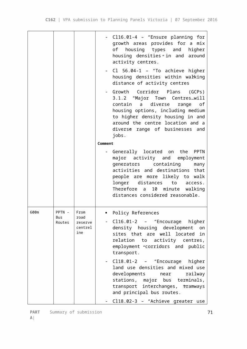
C162 | VPA submission to Planning Panels Victoria | 07 September 2016
The submitter requests deletion of any reference in the PSP to landfill gas migration buffers being internalised.
Issue 3:
The submitter requests that the PSP recognise that landfill gas migration buffers may encroach into the PSP and articulate the action required of developers in order to develop within the buffer
Submitter 33 – City of Melton
Issue 1:
Whilst it is considered that the proposed landfill expansion should seek to ensure all buffers are incorporated within the landfill site, given the current application results in a 500m landfill gas migration buffer affecting the Precinct, this should be identified on the Plan and considered as part of the UGZ schedule.
Issue 2:
What is the basis for MPA to make assumptions that landfill gas migration will not extend beyond the landfill site boundaries and that any buffers required to mitigate landfill gas migration can be provided within the landfill site.
Additional Landfill Issues
Submission 22 - Mount Atkinson Holdings
Issue 1:
Plan 2: The reference "Potential Melbourne Regional Landfill (Waste and Resource Recovery Hub of State Importance)"- reference should be removed all together or qualified by adding "Subject to Council / State Government Approval".
Issue 2:
Objective 3: remove reference to "future potential landfill" on Plans 2 & 3 as this is speculative given the current zoning of the Boral quarry land, which remains unquarried. Nominate on Plans 2 & 3 that the existing landfill permit is some 1.5kms away, consistent with the Jacobs Report.
Submission 21 - Landfill Operations
Issue 1:
Request that R36 be edited so that the operator of the landfill and the EPA must be consulted during the preparation of the Hopkins Road UDF
Issue 2:
Add new requirement at section 3.2.3 to require greater consideration of landfill "Allocation of land uses, building design and interface treatments must have regard to potential amenity impacts of the landfill on the proposed use or development and the potential for the proposed use or development to impact on the operation of the landfill"
Issue 3:
Request that Table 2 of the UGZ9 be amended to add missing sensitive uses to the list of prohibited uses for land within the sensitive use buffer.
Issue 4:
PART A| Summary of submission 71

C162 | VPA submission to Planning Panels Victoria | 07 September 2016
Request that a new Specific Provision is added to UGZ9 to trigger a planning permit for use of land (food preparation, manufacturing or warehousing, office, food & drink premises, office, retail, shop) within the sensitive use buffer with an application requirement for a reverse amenity and buffer assessment
Issue 5:
Add the EPA and the Department administering the Environmental Protection Act 1970 (Department) to clause 2.10 of the UGZ9 Specific Provision - referral of applications- Ravenhall Quarry- and add the use of land to the application types.
Issue 6:
Proposes that clause 37-07-13 of the UGZ be removed so that normal notice and review rights are reversed proximate to the landfill in order that the operator of the landfill is notified of applications, and has access to appeal rights.
Issue 7:
It is recommended that any application for subdivision, use and/or development of land within the PSP must demonstrate compliance with the Best Practice Environmental Management: Siting, Design, Operation and Rehabilitation of Landfills (Environmental Protection Authority,2014- Publication 788.2) to the satisfaction of the responsible authority, in consultation with the Environmental Protection Authority.
PART A| Summary of submission 72

C162 | VPA submission to Planning Panels Victoria | 07 September 2016
APPENDIX 2 Changes Matrix with reference to relevant submissions - September 2016
PART A| Summary of submission 73
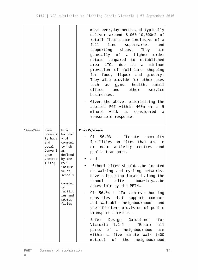
C162 | VPA submission to Planning Panels Victoria | 07 September 2016
APPENDIX 3 Planning Scheme Ordinance (Track Changed)
PART A| Summary of submission 74

C162 | VPA submission to Planning Panels Victoria | 07 September 2016
APPENDIX 4 Commonwealth Notice of Decision to Endorse the Program to Revise Melbourne UGB-February 2010
PART A| Summary of submission 75

C162 | VPA submission to Planning Panels Victoria | 07 September 2016
APPENDIX 5 Commonwealth Approval for Urban Development – 2013
PART A| Summary of submission 76
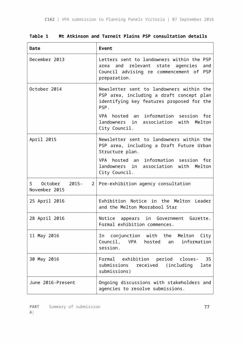
C162 | VPA submission to Planning Panels Victoria | 07 September 2016
PART A| Summary of submission 77