Embed Size (px)
Citation preview
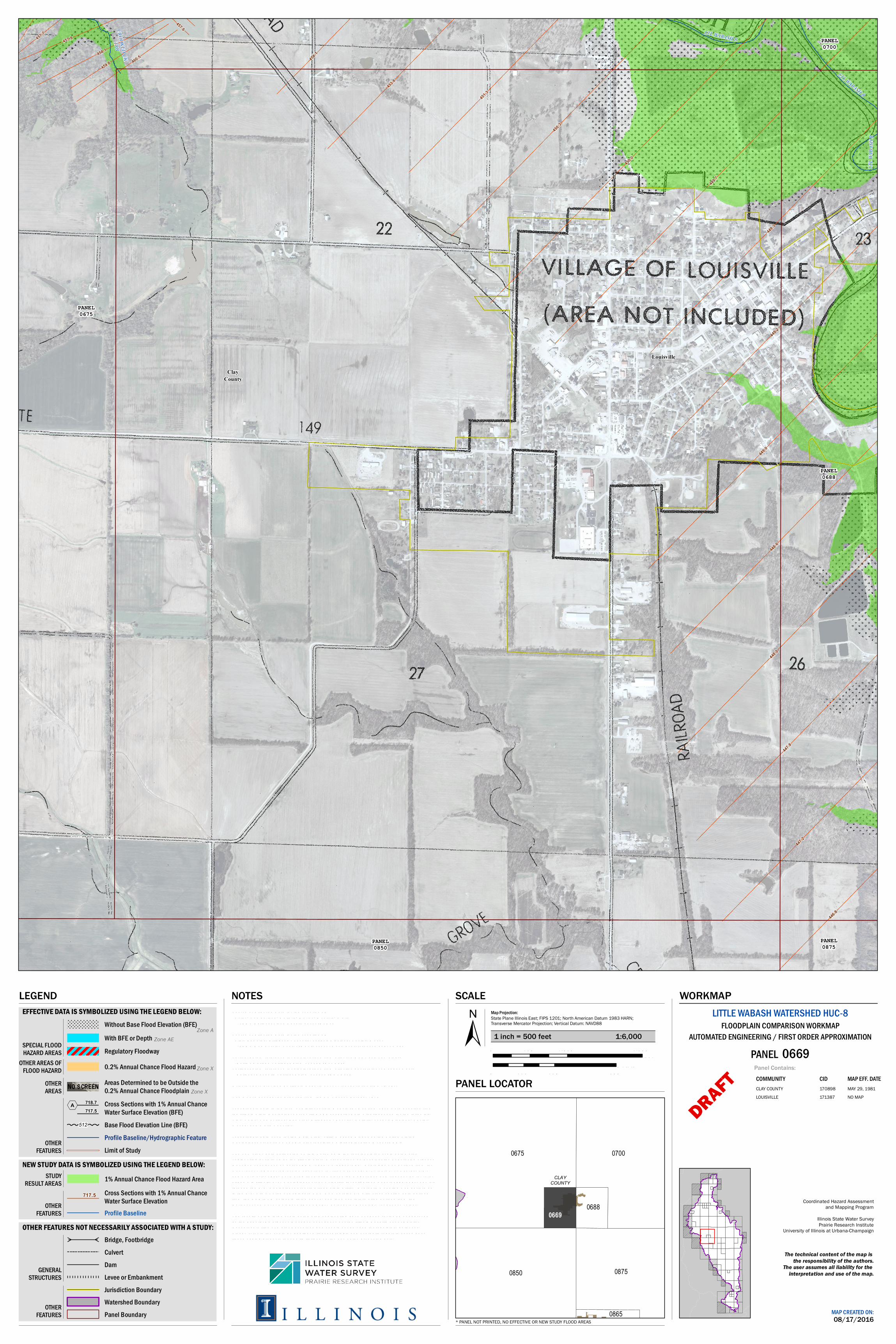
Louisville
ClayCounty
PANEL0675
PANEL0700
PANEL0850
PANEL0875
PANEL0688
457.6
457.7
454.1
457.8
459.8 460.5
446.8
458.1
453.6
451.3
447.2
447.8
448.2
449.2
448.6
450.3
449.3
449.0
450.0
449.7
LTL W
ABAS
H R
CROOKED CKTRB
LTL WABASH R
LTL WABASH R
NOTES
SCALE
0675 0700
0850 0875
0865
06880669
CLAYCOUNTY
±Map Projection:State Plane Illinois East; FIPS 1201; North American Datum 1983 HARN;Transverse Mercator Projection; Vertical Datum: NAVD88
fe e t0 1,000 2,000500
m e te rs0 250 500125
PANEL LOCATOR
LEGEND
MAP CREATED ON:08/17/2016
The technical content of the map is the responsibility of the authors.
The user assumes all liability for the interpretation and use of the map.
LITTLE WABASH WATERSHED HUC-8FLOODPLAIN COMPARISON WORKMAP
PANEL 0669Panel Contains:COMMUNITY CIDCLAY COUNTY 170898LOUISVILLE 171387
Source of Effe ctive Da ta for th e countie s of: Cole s, Cum b e rla nd, Ga lla tin, Ma rion, Moultrie , Wh ite -FEMA Na tiona l Flood Haza rd Laye r (NFHL)Source of Effe ctive Da ta for th e countie s of: Cla y, Edwa rds, Effing h a m , Faye tte , Ja spe r, Rich la nd, Sh e lby, Wayne -FEMA Ma p Se rvice Ce nte r (MSC), sca nne d a nd g e ore fe re nce d pa pe r m a psVe rtica l da tum re fe re nce for a ll e le va tions from e ffe ctive NFHL a nd ne w study: -North Am e rica n Ve rtica l Da tum of 1988 (NAVD88)Ve rtica l da tum re fe re nce for a ll e le va tions from e ffe ctive g e ore fe re nce d pa pe r m a ps: -Na tiona l Ge ode tic Ve rtica l Da tum of 1929 (NGVD29)O rth oim a g e ry provide d b y Illinois De pa rtm e nt of Tra nsporta tion (IDO T), 2011Com m unity b ounda rie s a cquire d from th e US Ce nsus Bure au, 2015Topog ra ph ic da ta in th e form of Dig ita l Te rra in Mode ls (DTMs) from 2011 we re a cquire d from th e Illinois Sta te Ge olog ica l Surve y (ISGS) Ge ospa tia l Da ta Cle a ring h ouse for th e following :Cla y, Cole s, Cum b e rla nd, Edwa rds, Effing h a m , Faye tte , Ga lla tin, Ja spe r, Rich la nd, Sh e lb y, Wayne , a nd Wh ite Countie s.Topog ra ph ic da ta use d for th e Ma in Ste m Little Wa b a sh Rive r wa s th e Unite d Sta te s Ge olog ica l Surve y (USGS) 10-m e te r re solution Dig ita l Ele va iton Mode l (DEM).Th e ne w study da ta de line a te d on th is workm a p is th e re sult of la rg e sca le a utom a te d e ng ine e ring pe rform e d b y th e Illinois Sta te Wa te r Surve y on b e h a lf of th e Fe de ra l Em e rg e ncy Ma na g e m e nt Ag e ncy a s pa rt of EMW-2015-CA-00063-S01. Hydrolog y wa s de rive d from th e m ost re ce nt re g iona l re g re ssion e qua tions for Illinois (Soong , D.T., Ish ii, A.L., Sh a rpe , J.B., a nd Ave ry, C.F., 2004, Estim a ting flood-pe a k disch a rg e m a g nitude s a nd fre que ncie s for rura l stre a m s in Illinois: U.S. Ge olog ica l Surve y Scie ntific Inve stig a tions Re port 2004-5103, 147 p.) th roug h th e U.S. Ge olog ica l Surve y’s Stre a m sta ts Utility. Hydraulic m ode ling wa s pe rform e d in th e U.S. Arm y Corps of Eng ine e rs HEC-RAS Ve rsion 4.1 with cross se ction da ta de rive d from th e DEM/DTM da ta se ts liste d a b ove , a nd la nd use inform a tion de rive d from th e Na tiona l La nd Cove r Da ta b a se (NLCD) 2011 da ta se t for Ma nning ’s roug h ne ss va lue s. Th e re sults of th is la rg e sca le autom a te d e ng ine e ring h a ve not b e e n re vie we d or a pprove d by th e Fe de ra l Em e rg e ncy Ma na g e m e nt Ag e ncy nor th e Illinois De pa rtm e nt of Na tura l Re source s-O ffice of Wa te r Re source s a nd sh ould not b e use d for re g ula tory purpose s. Ple a se re fe r to th e ye t to b e pub lish e d fina l h ydrolog ic a nd h ydraulic re port to accom pa ny fina l m a pping products for a ny lim ita tions on th e use of th e pre se nte d da ta.
1 inch = 500 feet 1:6,000
WORKMAP
OTHERAREAS
OTHER AREAS OFFLOOD HAZARD
SPECIAL FLOODHAZARD AREAS
* PANEL NOT PRINTED, NO EFFECTIVE OR NEW STUDY FLOOD AREAS
OTHERFEATURES
EFFECTIVE DATA IS SYMBOLIZED USING THE LEGEND BELOW:
NEW STUDY DATA IS SYMBOLIZED USING THE LEGEND BELOW:
OTHER FEATURES NOT NECESSARILY ASSOCIATED WITH A STUDY:
GENERALSTRUCTURES
OTHERFEATURES
OTHERFEATURES
STUDYRESULT AREAS
DRAFT MAP EFF. DATEMAY 29, 1981NO MAP
Coordinated Hazard Assessmentand Mapping Program
Illinois State Water SurveyPrairie Research Institute
University of Illinois at Urbana-Champaign
AUTOMATED ENGINEERING / FIRST ORDER APPROXIMATION
DamLevee or EmbankmentJurisdiction BoundaryWatershed BoundaryPanel Boundary
Profile Baseline
Cross Sections with 1% Annual ChanceWater Surface Elevation
717.5
1% Annual Chance Flood Hazard Area
Limit of StudyProfile Baseline/Hydrographic FeatureBase Flood Elevation Line (BFE)512
Cross Sections with 1% Annual ChanceWater Surface Elevation (BFE)
718.7,A 717.5
Areas Determined to be Outside the0.2% Annual Chance Floodplain Zone X
0.2% Annual Chance Flood Hazard Zone X
Without Base Flood Elevation (BFE)Zone A! ! ! ! ! ! ! ! ! ! ! !
! ! ! ! ! ! ! ! ! ! ! !
! ! ! ! ! ! ! ! ! ! ! !
! ! ! ! ! ! ! ! ! ! ! !
! ! ! ! ! ! ! ! ! ! !
! ! ! ! ! ! ! ! ! ! !
! ! ! ! ! ! ! ! ! ! !
CulvertBridge, Footbridge?
?
Regulatory FloodwayWith BFE or Depth Zone AE